
1959 Atlantic hurricane season
Encyclopedia
The 1959 Atlantic hurricane season officially began on June 15, 1959, and lasted until November 15, 1959. These dates conventionally delimit the period of each year when most tropical cyclone
s form in the Atlantic basin
. The season
began on May 28, before the official bounds, and had an unusual number of early-forming storms.
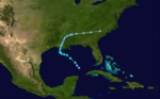
The most notable storm of 1959 was Hurricane Gracie
, which caused ten deaths when it made landfall near Beaufort, South Carolina
as well as millions in damage; another eleven were killed by a tornado
generated as Gracie weakened. Another notable storm was the Escuminac Hurricane, or Hurricane #3, which hit Escuminac, New Brunswick
on June 19 as a hurricane, sinking 22 boats and killing 35 men.
(ACE) rating of 77. ACE is, broadly speaking, a measure of the power of the hurricane multiplied by the length of time it existed, so storms that last a long time, as well as particularly strong hurricanes, have high ACEs. ACE is only calculated for full advisories on tropical systems at or exceeding 34 knots (39 mph, 63 km/h) or tropical storm strength. Subtropical storms are not included in the ACE value.
and the Gulf of Mexico
developed into a tropical depression on May 28. Conditions were generally favorable, despite being outside of the official season, and it strengthened into a tropical storm the next day. Arlene reached its peak of 60 mph (95 km/h) before unfavorable conditions weakened it to a minimal tropical storm at its Louisiana
landfall on May 30. It moved northeastward and dissipated on June 2 after causing $500,000 in damage (1959 USD) and one death.
, bringing heavy rain and severe weather across the state. Later that day, it became a tropical storm, and it became a hurricane the next day as it raced into the north Atlantic. It became extratropical late on the June 19, and hit near Escuminac, New Brunswick
, on the night of June 19 and June 20, where it caused massive damage to the fishing community.
The hurricane caused 33 deaths and considerable damage as an extratropical cyclone. It also caused $1,656,000 (1959 USD) in damage in Florida, most of which came from a single tornado in Miami.
on July 9 as a minimal hurricane. It turned northeast, and weakened to a tropical depression. As it sped by the mouth of the Chesapeake Bay
, the instability of the atmosphere allowed Cindy to restrengthen to a tropical storm. It continued northeastward, and became extratropical on July 11, after causing one death.
. It developed thunderstorm activity over the Bahamas, and as it drifted westward, it steadily organized into a tropical depression on July 23. It continued slowly westward, and became a tropical storm later that day. Debra turned northward due to the subtropical ridge, and hit between Freeport, Texas
and Galveston, Texas
on July 25 as a minimal hurricane. It weakened over Texas
, and dissipated over western Oklahoma
. Debra caused a total of $7 million (1959 dollars) in damage, but no fatalities.
. It became a tropical storm the next day, and reached a peak of 60 mph (95 km/h) winds as it moved through the islands. Its rapid movement contributed to its demise, however, and upper level winds weakened it until dissipation on the August 19 while south of the Dominican Republic
.
. It hit the state as a 120 mph (200 km/h) major hurricane on September 29, and caused tornadoes across the Southeast United States. Gracie caused a total of 22 casualties and $14 million (1959 USD) in damage, much of which came from tornadoes.
.
on October 8 as a 60 mph tropical storm. Irene dissipated that day over Georgia
, causing minor damage.
through the Caribbean Sea, producing squally weather. A low formed south of Jamaica on October 15. Soon after merging with another low moving eastward from the southern Gulf of Mexico, the combined system developed into a tropical storm in the southeast Gulf of Mexico on October 17. Judith moved over Florida the next day after reaching hurricane strength, and moved rapidly out to sea, reaching a peak of 80 mph (130 km/h), but steadily weakened until dissipating on the October 21 east of Bermuda
.
when Dennis
formed on July 5 and Emily
formed on July 11.
Tropical cyclone
A tropical cyclone is a storm system characterized by a large low-pressure center and numerous thunderstorms that produce strong winds and heavy rain. Tropical cyclones strengthen when water evaporated from the ocean is released as the saturated air rises, resulting in condensation of water vapor...
s form in the Atlantic basin
Atlantic Basin
The Atlantic Basin is the Atlantic Ocean.Atlantic Basin may also refer to:* Atlantic Basin Iron Works, an ironworks that operated in Brooklyn, New York, in the early to mid-20th century...
. The season
Atlantic hurricane season
The Atlantic hurricane season is the period in a year when hurricanes usually form in the Atlantic Ocean. Tropical cyclones in the North Atlantic are called hurricanes, tropical storms, or tropical depressions. In addition, there have been several storms over the years that have not been fully...
began on May 28, before the official bounds, and had an unusual number of early-forming storms.
The most notable storm of 1959 was Hurricane Gracie
Hurricane Gracie
Hurricane Gracie was a major hurricane that formed in September 1959, the strongest during the 1959 Atlantic hurricane season and the most intense to strike the United States since Hurricane Hazel in 1954...
, which caused ten deaths when it made landfall near Beaufort, South Carolina
Beaufort, South Carolina
Beaufort is a city in and the county seat of Beaufort County, South Carolina, United States. Chartered in 1711, it is the second-oldest city in South Carolina, behind Charleston. The city's population was 12,361 in the 2010 census. It is located in the Hilton Head Island-Beaufort Micropolitan...
as well as millions in damage; another eleven were killed by a tornado
Tornado
A tornado is a violent, dangerous, rotating column of air that is in contact with both the surface of the earth and a cumulonimbus cloud or, in rare cases, the base of a cumulus cloud. They are often referred to as a twister or a cyclone, although the word cyclone is used in meteorology in a wider...
generated as Gracie weakened. Another notable storm was the Escuminac Hurricane, or Hurricane #3, which hit Escuminac, New Brunswick
New Brunswick
New Brunswick is one of Canada's three Maritime provinces and is the only province in the federation that is constitutionally bilingual . The provincial capital is Fredericton and Saint John is the most populous city. Greater Moncton is the largest Census Metropolitan Area...
on June 19 as a hurricane, sinking 22 boats and killing 35 men.
Season summary
The season's activity was reflected with a cumulative accumulated cyclone energyAccumulated cyclone energy
Accumulated cyclone energy is a measure used by the National Oceanic and Atmospheric Administration to express the activity of individual tropical cyclones and entire tropical cyclone seasons, particularly the North Atlantic hurricane season. It uses an approximation of the energy used by a...
(ACE) rating of 77. ACE is, broadly speaking, a measure of the power of the hurricane multiplied by the length of time it existed, so storms that last a long time, as well as particularly strong hurricanes, have high ACEs. ACE is only calculated for full advisories on tropical systems at or exceeding 34 knots (39 mph, 63 km/h) or tropical storm strength. Subtropical storms are not included in the ACE value.
Tropical Storm Arlene
A tropical wave moving through the Caribbean SeaCaribbean Sea
The Caribbean Sea is a sea of the Atlantic Ocean located in the tropics of the Western hemisphere. It is bounded by Mexico and Central America to the west and southwest, to the north by the Greater Antilles, and to the east by the Lesser Antilles....
and the Gulf of Mexico
Gulf of Mexico
The Gulf of Mexico is a partially landlocked ocean basin largely surrounded by the North American continent and the island of Cuba. It is bounded on the northeast, north and northwest by the Gulf Coast of the United States, on the southwest and south by Mexico, and on the southeast by Cuba. In...
developed into a tropical depression on May 28. Conditions were generally favorable, despite being outside of the official season, and it strengthened into a tropical storm the next day. Arlene reached its peak of 60 mph (95 km/h) before unfavorable conditions weakened it to a minimal tropical storm at its Louisiana
Louisiana
Louisiana is a state located in the southern region of the United States of America. Its capital is Baton Rouge and largest city is New Orleans. Louisiana is the only state in the U.S. with political subdivisions termed parishes, which are local governments equivalent to counties...
landfall on May 30. It moved northeastward and dissipated on June 2 after causing $500,000 in damage (1959 USD) and one death.
Tropical Storm Beulah
The precursor to Tropical Storm Beulah was a cold front that stalled in the Bay of Campeche on June 15. It drifted northwestward, becoming a tropical storm the next day. As it neared the Mexican coastline, a building ridge of high pressure to its north pushed Beulah southward, where upper level winds caused it to dissipate on June 18.Hurricane Three
On June 18, a rapidly northeastward moving tropical wave near a cold front developed into a tropical depression. It crossed FloridaFlorida
Florida is a state in the southeastern United States, located on the nation's Atlantic and Gulf coasts. It is bordered to the west by the Gulf of Mexico, to the north by Alabama and Georgia and to the east by the Atlantic Ocean. With a population of 18,801,310 as measured by the 2010 census, it...
, bringing heavy rain and severe weather across the state. Later that day, it became a tropical storm, and it became a hurricane the next day as it raced into the north Atlantic. It became extratropical late on the June 19, and hit near Escuminac, New Brunswick
Escuminac, New Brunswick
Escuminac is a Canadian rural community in Northumberland County, New Brunswick.Located on the south shore of Miramichi Bay, the community is several kilometres west of Point Escuminac, the southeastern limit of the bay. Canada's largest inshore fishing vessel harbour is home to the local fishing...
, on the night of June 19 and June 20, where it caused massive damage to the fishing community.
The hurricane caused 33 deaths and considerable damage as an extratropical cyclone. It also caused $1,656,000 (1959 USD) in damage in Florida, most of which came from a single tornado in Miami.
Hurricane Cindy
A trough of low pressure from a frontal boundary developed into a tropical depression on July 5 off the coast of Florida. It moved northeastward, where it became a tropical storm on the July 7 A small hurricane, Cindy drifted to the west, and hit north of Charleston, South CarolinaCharleston, South Carolina
Charleston is the second largest city in the U.S. state of South Carolina. It was made the county seat of Charleston County in 1901 when Charleston County was founded. The city's original name was Charles Towne in 1670, and it moved to its present location from a location on the west bank of the...
on July 9 as a minimal hurricane. It turned northeast, and weakened to a tropical depression. As it sped by the mouth of the Chesapeake Bay
Chesapeake Bay
The Chesapeake Bay is the largest estuary in the United States. It lies off the Atlantic Ocean, surrounded by Maryland and Virginia. The Chesapeake Bay's drainage basin covers in the District of Columbia and parts of six states: New York, Pennsylvania, Delaware, Maryland, Virginia, and West...
, the instability of the atmosphere allowed Cindy to restrengthen to a tropical storm. It continued northeastward, and became extratropical on July 11, after causing one death.
Hurricane Debra
The development of Hurricane Debra can be attributed to a cold core upper level lowCold-core low
A cold-core low, also known as a cold low or cold-core cyclone, is a cyclone aloft which has an associated cold pool of air residing at high altitude within the Earth's troposphere. It is a low pressure system which strengthens with height in accordance with the thermal wind relationship. These...
. It developed thunderstorm activity over the Bahamas, and as it drifted westward, it steadily organized into a tropical depression on July 23. It continued slowly westward, and became a tropical storm later that day. Debra turned northward due to the subtropical ridge, and hit between Freeport, Texas
Freeport, Texas
Freeport is a city in Brazoria County, Texas within the Houston–Sugar Land–Baytown metropolitan area and is situated in Southeast Texas. As of the 2000 U.S...
and Galveston, Texas
Galveston, Texas
Galveston is a coastal city located on Galveston Island in the U.S. state of Texas. , the city had a total population of 47,743 within an area of...
on July 25 as a minimal hurricane. It weakened over Texas
Texas
Texas is the second largest U.S. state by both area and population, and the largest state by area in the contiguous United States.The name, based on the Caddo word "Tejas" meaning "friends" or "allies", was applied by the Spanish to the Caddo themselves and to the region of their settlement in...
, and dissipated over western Oklahoma
Oklahoma
Oklahoma is a state located in the South Central region of the United States of America. With an estimated 3,751,351 residents as of the 2010 census and a land area of 68,667 square miles , Oklahoma is the 28th most populous and 20th-largest state...
. Debra caused a total of $7 million (1959 dollars) in damage, but no fatalities.
Tropical Storm Edith
Tropical Storm Edith developed from a tropical wave on August 17, east of the Lesser AntillesLesser Antilles
The Lesser Antilles are a long, partly volcanic island arc in the Western Hemisphere. Most of its islands form the eastern boundary of the Caribbean Sea with the Atlantic Ocean, with the remainder located in the southern Caribbean just north of South America...
. It became a tropical storm the next day, and reached a peak of 60 mph (95 km/h) winds as it moved through the islands. Its rapid movement contributed to its demise, however, and upper level winds weakened it until dissipation on the August 19 while south of the Dominican Republic
Dominican Republic
The Dominican Republic is a nation on the island of La Hispaniola, part of the Greater Antilles archipelago in the Caribbean region. The western third of the island is occupied by the nation of Haiti, making Hispaniola one of two Caribbean islands that are shared by two countries...
.
Hurricane Flora
The combination of a trough of low pressure and a tropical wave developed into a tropical depression on September 9 in the tropical Atlantic. It turned northeastward and became a tropical storm on the September 10 and a hurricane on September 11. As Flora accelerated over the northern Atlantic, it lost its tropical characteristics on the September 12, remaining a powerful extratropical cyclone over the next two days.Hurricane Gracie
Hurricane Gracie had an unusual track, constantly switching directions as it headed towards South CarolinaSouth Carolina
South Carolina is a state in the Deep South of the United States that borders Georgia to the south, North Carolina to the north, and the Atlantic Ocean to the east. Originally part of the Province of Carolina, the Province of South Carolina was one of the 13 colonies that declared independence...
. It hit the state as a 120 mph (200 km/h) major hurricane on September 29, and caused tornadoes across the Southeast United States. Gracie caused a total of 22 casualties and $14 million (1959 USD) in damage, much of which came from tornadoes.
Hurricane Hannah
An upper level trough over the central Atlantic caused the development of a tropical depression on September 27. It rapidly strengthened the next day, reaching hurricane strength on the night of September 28. It reached a peak of 125 mph on October 1, but was only a threat to shipping. After turning to the east, it remained a hurricane until October 8, where it became extratropical south of IcelandIceland
Iceland , described as the Republic of Iceland, is a Nordic and European island country in the North Atlantic Ocean, on the Mid-Atlantic Ridge. Iceland also refers to the main island of the country, which contains almost all the population and almost all the land area. The country has a population...
.
Tropical Storm Irene
A dissipating cold front that left behind a trough of low pressure in the northern Gulf of Mexico formed into a tropical depression on October 6. It became a tropical storm the next day, and hit near Pensacola, FloridaPensacola, Florida
Pensacola is the westernmost city in the Florida Panhandle and the county seat of Escambia County, Florida, United States of America. As of the 2000 census, the city had a total population of 56,255 and as of 2009, the estimated population was 53,752...
on October 8 as a 60 mph tropical storm. Irene dissipated that day over Georgia
Georgia (U.S. state)
Georgia is a state located in the southeastern United States. It was established in 1732, the last of the original Thirteen Colonies. The state is named after King George II of Great Britain. Georgia was the fourth state to ratify the United States Constitution, on January 2, 1788...
, causing minor damage.
Hurricane Judith
A disturbance moved along the Intertropical Convergence ZoneIntertropical Convergence Zone
The Intertropical Convergence Zone , known by sailors as The Doldrums, is the area encircling the earth near the equator where winds originating in the northern and southern hemispheres come together....
through the Caribbean Sea, producing squally weather. A low formed south of Jamaica on October 15. Soon after merging with another low moving eastward from the southern Gulf of Mexico, the combined system developed into a tropical storm in the southeast Gulf of Mexico on October 17. Judith moved over Florida the next day after reaching hurricane strength, and moved rapidly out to sea, reaching a peak of 80 mph (130 km/h), but steadily weakened until dissipating on the October 21 east of Bermuda
Bermuda
Bermuda is a British overseas territory in the North Atlantic Ocean. Located off the east coast of the United States, its nearest landmass is Cape Hatteras, North Carolina, about to the west-northwest. It is about south of Halifax, Nova Scotia, Canada, and northeast of Miami, Florida...
.
Records
The season set records for the earliest formation of its fourth and fifth storms. Hurricane Cindy was named on July 7, and Hurricane Debra first reached tropical storm strength on July 23, following the development of Tropical Storm Arlene, Tropical Storm Beulah and Hurricane #3. Both of these records were broken in the 2005 season2005 Atlantic hurricane season
The 2005 Atlantic hurricane season was the most active Atlantic hurricane season in recorded history, repeatedly shattering numerous records. The impact of the season was widespread and ruinous with an estimated 3,913 deaths and record damage of about $159.2 billion...
when Dennis
Hurricane Dennis
Hurricane Dennis was an early-forming major hurricane in the Caribbean and Gulf of Mexico during the very active 2005 Atlantic hurricane season. Dennis was the fourth named storm, second hurricane, and first major hurricane of the season...
formed on July 5 and Emily
Hurricane Emily (2005)
Hurricane Emily was a powerful, early season tropical cyclone that caused significant damage across the Caribbean Sea to Mexico. A Cape Verde-type hurricane, the storm formed on July 10, 2005, in the central Atlantic Ocean before passing through the Windward Islands on July 14...
formed on July 11.
Storm names
The following names were used for named storms (tropical storms and hurricanes) that formed in the North Atlantic in 1959. All names in this list were first time in 1959.
|
|
Retirement
Gracie would later be retired, though it is unclear if the name was retired or not.See also
- List of Atlantic hurricanes
- List of Atlantic hurricane seasons