
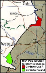
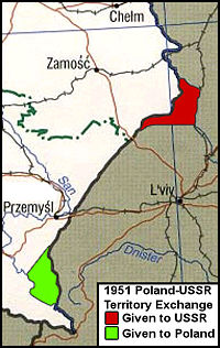
1951 Polish-Soviet territorial exchange
Encyclopedia
Border
Borders define geographic boundaries of political entities or legal jurisdictions, such as governments, sovereign states, federated states and other subnational entities. Some borders—such as a state's internal administrative borders, or inter-state borders within the Schengen Area—are open and...
adjustments signed in Moscow between the People's Republic of Poland
People's Republic of Poland
The People's Republic of Poland was the official name of Poland from 1952 to 1990. Although the Soviet Union took control of the country immediately after the liberation from Nazi Germany in 1944, the name of the state was not changed until eight years later...
and the Soviet Union
Soviet Union
The Soviet Union , officially the Union of Soviet Socialist Republics , was a constitutionally socialist state that existed in Eurasia between 1922 and 1991....
regarding roughly 480 km² (185 sq mi) of land, along their mutual border. The exchange was made to the decisive economic benefit of the Soviet Union due to rich deposits of coal given up by Poland; discovered already well before World War II. Within eight years following the agreement, the Russians buit four large coal mines there with the total mining capacity of 15 million ton annually.
In exchange, the Soviet Union ceded part of the Ukrainian SSR's Drohobych Oblast
Drohobych Oblast
Drohobych Oblast , was an oblast in the Ukrainian SSR. It had a territory of 9.6 thousands of km³, and population of 853 thousand .-History:...
(1939–1959): the city of Ustrzyki Dolne
Ustrzyki Dolne
Ustrzyki Dolne is a town in south-eastern Poland, close to the border with Ukraine, with 9,383 inhabitants .Situated in the Subcarpathian Voivodeship , it is the capital of Bieszczady County....
and the villages of Czarna
Czarna, Bieszczady County
Czarna is a village in Bieszczady County, Subcarpathian Voivodeship, in south-eastern Poland, close to the border with Ukraine. It is the seat of the gmina called Gmina Czarna...
(Ukrainian: Chorna), Shevchenko (whose name was restored back to prewar Polish name Lutowiska
Lutowiska
Lutowiska is a village in Bieszczady County, in the Subcarpathian Voivodeship of south-eastern Poland, close to the border with Ukraine.It is the seat of the gmina called Gmina Lutowiska...
in 1957), Krościenko
Kroscienko, Bieszczady County
Krościenko is a village in the administrative district of Gmina Ustrzyki Dolne, within Bieszczady County, Subcarpathian Voivodeship, in south-eastern Poland, near the border with the Ukraine. It lies approximately north-east of Ustrzyki Dolne and south-east of the regional capital Rzeszów.The...
, Bandrów Narodowy
Bandrów Narodowy
Bandrów Narodowy is a village in the administrative district of Gmina Ustrzyki Dolne, within Bieszczady County, Subcarpathian Voivodeship, in south-eastern Poland, near the border with the Ukraine. It lies approximately south-east of Ustrzyki Dolne and south-east of the regional capital...
, Bystre
Bystre, Bieszczady County
Bystre is a village in the administrative district of Gmina Czarna, within Bieszczady County, Subcarpathian Voivodeship, in south-eastern Poland, close to the border with Ukraine. It lies approximately east of Czarna, south-east of Ustrzyki Dolne, and south-east of the regional capital...
and Liskowate
Liskowate
Liskowate is a village in the administrative district of Gmina Ustrzyki Dolne, within Bieszczady County, in the Subcarpathian Voivodeship of south-eastern Poland, near the border with the Ukraine. It lies approximately north of Ustrzyki Dolne and south-east of the regional capital...
. All of this territory became part of the Krosno Voivodeship
Krosno Voivodeship
Krosno Voivodeship was a unit of administrative division and local government in Poland in years 1975–1998, superseded by Subcarpathian Voivodeship . Its capital city was Krosno....
in 1975, and of the Subcarpathian Voivodeship
Subcarpathian Voivodeship
Podkarpackie Voivodeship , or Subcarpathian Voivodeship, is a voivodeship, or province, in extreme-southeastern Poland. Its administrative capital and largest city is Rzeszów...
on 1 January 1999. It was a stretch of barren land with low quality soil and without any natural resources.
Poland gave up part of the Lublin Voivodship, with the cities of Bełz (Ukrainian: Belz
Belz
Belz , a small city in the Lviv Oblast of Western Ukraine, near the border with Poland, is located between the Solokiya river and the Rzeczyca stream....
), Uhnów ( Uhniv
Uhniv
Uhniv is a city in the Lviv Oblast of western Ukraine. Population is 1,021 .Uhniv is the smallest city of Ukraine aside couple of cities in the Zone of alienation in the northern Ukraine. It is part of Sokal Raion and is located 22 km from Belz and 21 km from Rava Ruska. The capital of...
), Krystynopol ( Chervonohrad
Chervonohrad
Chervonohrad is a city located in the Lviv Oblast of western Ukraine. The city is designated as a separate raion within the oblast. It about 62 km north of Lviv and 7 km from Sokal. The population numbers 68,300 inhabitants....
) and Waręż . Currently all of this territory is part of the Sokalskyi Raion , Ukraine
Ukraine
Ukraine is a country in Eastern Europe. It has an area of 603,628 km², making it the second largest contiguous country on the European continent, after Russia...
.
After World War II
World War II
World War II, or the Second World War , was a global conflict lasting from 1939 to 1945, involving most of the world's nations—including all of the great powers—eventually forming two opposing military alliances: the Allies and the Axis...
, the territory of Poland
Poland
Poland , officially the Republic of Poland , is a country in Central Europe bordered by Germany to the west; the Czech Republic and Slovakia to the south; Ukraine, Belarus and Lithuania to the east; and the Baltic Sea and Kaliningrad Oblast, a Russian exclave, to the north...
changed dramatically, moving westwards. Poland gained the former German provinces of Silesia
Silesia
Silesia is a historical region of Central Europe located mostly in Poland, with smaller parts also in the Czech Republic, and Germany.Silesia is rich in mineral and natural resources, and includes several important industrial areas. Silesia's largest city and historical capital is Wrocław...
and Pomerania
Pomerania
Pomerania is a historical region on the south shore of the Baltic Sea. Divided between Germany and Poland, it stretches roughly from the Recknitz River near Stralsund in the West, via the Oder River delta near Szczecin, to the mouth of the Vistula River near Gdańsk in the East...
, with the eastern part of Brandenburg
Brandenburg
Brandenburg is one of the sixteen federal-states of Germany. It lies in the east of the country and is one of the new federal states that were re-created in 1990 upon the reunification of the former West Germany and East Germany. The capital is Potsdam...
and the southern part of East Prussia
East Prussia
East Prussia is the main part of the region of Prussia along the southeastern Baltic Coast from the 13th century to the end of World War II in May 1945. From 1772–1829 and 1878–1945, the Province of East Prussia was part of the German state of Prussia. The capital city was Königsberg.East Prussia...
. The eastern border of the country was established roughly along the so-called Curzon line
Curzon Line
The Curzon Line was put forward by the Allied Supreme Council after World War I as a demarcation line between the Second Polish Republic and Bolshevik Russia and was supposed to serve as the basis for a future border. In the wake of World War I, which catalysed the Russian Revolution of 1917, the...
, leaving Białystok in Poland and Lviv
Lviv
Lviv is a city in western Ukraine. The city is regarded as one of the main cultural centres of today's Ukraine and historically has also been a major Polish and Jewish cultural center, as Poles and Jews were the two main ethnicities of the city until the outbreak of World War II and the following...
in the Soviet Ukraine.
The border of Poland and the Soviet Union, delimited on the 1945 agreement
Border Agreement between Poland and the USSR of 16 August 1945
The Border Agreement between Poland and the USSR of 16 August 1945 refers to the ratification of borders between the Union of Soviet Socialist Republics and the Republic of Poland signed by the Provisional Government of National Unity formed by the Polish communists...
remained almost unchanged until the early 1950s (with a minor correction in 1948, when the village of Medyka
Medyka
Medyka is a village in Przemyśl County, Subcarpathian Voivodeship, in south-eastern Poland, close to the border with Ukraine. It is the seat of the gmina called Gmina Medyka...
near Przemyśl
Przemysl
Przemyśl is a city in south-eastern Poland with 66,756 inhabitants, as of June 2009. In 1999, it became part of the Podkarpackie Voivodeship; it was previously the capital of Przemyśl Voivodeship....
was transferred to Poland). Then, rich deposits of coal were confirmed in the so-called Bug River
Bug River
The Bug River is a left tributary of the Narew river flows from central Ukraine to the west, passing along the Ukraine-Polish and Polish-Belarusian border and into Poland, where it empties into the Narew river near Serock. The part between the lake and the Vistula River is sometimes referred to as...
knee – Polish postwar territory between the upper Bug and the Sołokija river. The Soviet government decided to gain control over this land, which possessed not only coal, but also fertile black soil
Chernozem
Chernozem , also known as "black land" or "black earth", is a black-coloured soil containing a high percentage of humus 7% to 15%, and high percentages of phosphoric acids, phosphorus and ammonia...
.
Agreement concerning the exchange
On February 15, 1951 the governments of People's Republic of PolandPeople's Republic of Poland
The People's Republic of Poland was the official name of Poland from 1952 to 1990. Although the Soviet Union took control of the country immediately after the liberation from Nazi Germany in 1944, the name of the state was not changed until eight years later...
and Union of Soviet Socialist Republics signed a bill which ratified the change of the eastern border of Poland. According to the agreement, Poland transferred to the Ukrainian Soviet Socialist Republic 480 km² (185 sq mi) of territory located west of the town of Sokal
Sokal
Sokal is a town located on the banks of the Bug River in the Lviv Oblast of western Ukraine. Serving as the administrative center of the Sokal Raion , the city itself also ranks as a separate raion within the oblast.- History :...
, which had been located in the Hrubieszów
Hrubieszów
Hrubieszów is a town in southeastern Poland, with a population of 18,661 . It is the capital of Hrubieszów County. Since 1999 Hrubieszów has been part of Lublin Voivodeship . Earlier, 1975–98, it had been part of Zamość Province...
county of the Lublin Voivodeship
Lublin Voivodeship
- Administrative division :Lublin Voivodeship is divided into 24 counties : 4 city counties and 20 land counties. These are further divided into 213 gminas....
(together with the towns of Bełz, Sokal, Krystynopol and Uhnów as well as the rail line Rawa Ruska - Krystynopol). Currently, these towns are located in the Sokal Raion of the Lviv Oblast
Lviv Oblast
Lviv Oblast is an oblast in western Ukraine. The administrative center of the oblast is the city of Lviv.-History:The oblast was created as part of the Ukrainian Soviet Socialist Republic on December 4, 1939...
. Several coal mines have been constructed there, and the former town of Krystynopol is now known as Chervonohrad
Chervonohrad
Chervonohrad is a city located in the Lviv Oblast of western Ukraine. The city is designated as a separate raion within the oblast. It about 62 km north of Lviv and 7 km from Sokal. The population numbers 68,300 inhabitants....
.
Even though the territory ceded to Poland was roughly as large as the territory transferred to the Soviet Union, the land around Ustrzyki Dolne was attractive only for tourism
Bieszczady Mountains
Bieszczady is the Polish name for a mountain range in the extreme south-east of Poland, extending into Ukraine and Slovakia...
. It lacked industry, natural resources, and its soil was not so fertile. Also, in the early 1950s it was almost deserted. Currently, the territory is part of Bieszczady County
Bieszczady County
Bieszczady County is a unit of territorial administration and local government in Subcarpathian Voivodeship, in the extreme south-east of Poland, on the border with Ukraine. It takes its name from the Bieszczady mountain range. The county was created on January 1, 1999, as a result of the Polish...
(Subcarpathian Voivodeship
Subcarpathian Voivodeship
Podkarpackie Voivodeship , or Subcarpathian Voivodeship, is a voivodeship, or province, in extreme-southeastern Poland. Its administrative capital and largest city is Rzeszów...
). In 1968 the Polish government constructed a 664 m (2,178 ft) long, 81 m (266 ft) high Solina Dam
Solina Dam
The Solina Dam is the largest dam and hydroelectric plant in Poland. It is located in Lesko County in the Bieszczady Mountains area of south-eastern Poland.-History:...
there on the San river, which created Lake Solina.
According to the mutual agreement, all real estate present on the exchanged territories (buildings, infrastructure, farms, rail lines) was automatically transferred to the new owner and both sides relinquished all future claims. However, moveable goods were allowed to be kept under the condition that the owners had to take them when they left. The Polish population of the Sokal area was moved in May 1951, mainly to the Recovered Territories
Recovered Territories
Recovered or Regained Territories was an official term used by the People's Republic of Poland to describe those parts of pre-war Germany that became part of Poland after World War II...
. The inhabitants of the town of Belz settled in Ustrzyki Dolne.
Officially, the Polish side claimed that the exchange took place on Warsaw’s initiative. However, in the early 1950s, Poland was de facto ruled by Moscow
Moscow
Moscow is the capital, the most populous city, and the most populous federal subject of Russia. The city is a major political, economic, cultural, scientific, religious, financial, educational, and transportation centre of Russia and the continent...
and all decisions were taken there. The Soviets claimed that the area of Ustrzyki possessed deposits of oil, but it turned out that all sources had been exploited.
See also
- Territorial changes of Poland after World War IITerritorial changes of Poland after World War IIThe territorial changes of Poland after World War II were very extensive. In 1945, following the Second World War, Poland's borders were redrawn following the decisions made at the Potsdam Conference of 1945 at the insistence of the Soviet Union...
- Polish areas annexed by the Soviet UnionPolish areas annexed by the Soviet UnionImmediately after the German invasion of Poland in 1939, which marked the beginning of World War II, the Soviet Union invaded the eastern regions of the Second Polish Republic, which Poles referred to as the "Kresy," and annexed territories totaling 201,015 km² with a population of 13,299,000...
- Curzon LineCurzon LineThe Curzon Line was put forward by the Allied Supreme Council after World War I as a demarcation line between the Second Polish Republic and Bolshevik Russia and was supposed to serve as the basis for a future border. In the wake of World War I, which catalysed the Russian Revolution of 1917, the...
- KresyKresyThe Polish term Kresy refers to a land considered by Poles as historical eastern provinces of their country. Today, it makes western Ukraine, western Belarus, as well as eastern Lithuania, with such major cities, as Lviv, Vilnius, and Hrodna. This territory belonged to the Polish-Lithuanian...
- List of national border changes since World War I
- History of the Ukrainian minority in Poland
- Repatriation of Ukrainians from Poland to USSR (1944-1946)Repatriation of Ukrainians from Poland to USSR (1944-1946)The repatriation of Ukrainians from Poland to the Soviet Union in 1944-1946 was part of the World War II evacuation and expulsion that sought the ethnic consolidation of the territory of Poland and Ukraine...
- Operation Vistula
- Repatriation of Ukrainians from Poland to USSR (1944-1946)
- Polish minority in UkrainePolish minority in UkraineThe Polish minority in Ukraine officially numbers about 144,130 , of whom 21,094 speak Polish as their first language. The history of Polish settlement in current territory of Ukraine dates back to 1030–31...
- Repatriation of Poles (1944–1946)#From Ukraine
- Repatriation of Poles (1955–1959)Repatriation of Poles (1955–1959)Repatriation of Polish population in the years of 1955–1959 was the second wave of forced repatriation of the Poles living in the territories annexed by the Soviet Union. It was the aftermath of the death of Stalin and start of destalinization...