
1924 Atlantic hurricane season
Encyclopedia
The 1924 Atlantic hurricane season ran through the summer and the first half of fall in 1924. The season was average with 11 storms; three became hurricanes and two others became major hurricanes. An early season tropical storm hit Belize
on June 18 and Mexico
on June 21. Two hurricanes formed in August and followed a similar path, forming in the tropical Atlantic, hitting the Lesser Antilles
, passing west of Bermuda
, becoming extratropical, and eventually hitting Nova Scotia
.
A hurricane also struck Florida in early September. A second tropical storm would also hit Florida later in the month. The most intense tropical cyclone of the season
struck western Cuba as a Category 5 hurricane and eventually moved ashore near Marco Island, Florida
with weaker winds in October. A November tropical storm hit Jamaica
and Cuba
, becoming a hurricane over the western Atlantic Ocean.
on June 18. It made landfall
on northern Belize
with estimated winds near 45 mph (75 km/h). Pressures were progressively decreasing over the preceding days in the northwestern Caribbean Sea
. The tropical system crossed the Yucatán Peninsula
, emerging over the Bay of Campeche
on June 19 with 40 mph (65 km/h) winds. It re-strengthened over water, and it re-attained winds of 45 mph (75 km/h). Early on June 21, it made landfall 115 miles (185 km) south of Tampico, Tamaulipas. It dissipated over land. The cyclone was classified as a weak disturbance, and strong winds were not recorded throughout the life span of the storm. Squall
s affected the Texas coast, prompting advisories for small watercraft. Heavy rain
fall was reported in Mexico.
off the east coast of Florida resulted in the formation of a tropical storm, which possessed some hybrid cyclone
characteristics. The storm tracked northeastward, steadily intensifying to reach peak winds of 65 mph (100 km/h) as it passed near the Outer Banks
of North Carolina. Later it weakened over cooler waters, and on July 30 it was absorbed by a cold front to the south of Nova Scotia.
on August 18. On August 19, it passed east of San Juan, Puerto Rico
and re-entered the Atlantic Ocean. On August 20, it quickly strengthened to the equivalent of a Category 1 hurricane on the Saffir-Simpson Hurricane Scale
. The cyclone slowed and turned west on August 21, and it continued to strengthen east of the northern Bahamas
. The cyclone strengthened to a peak intensity of 135 mph (215 km/h) north of Grand Bahama
on August 24. At the time, the storm was nearly stationary. Several ships reported winds of hurricane force, rough seas, and atmospheric pressure
readings to 970 mbar (28.67 inHg) from August 23 through August 25. The cyclone turned sharply north, remaining east of the East Coast
. On August 25, it quickly weakened, and it passed close to Cape Hatteras
on August 26. It transitioned to an extratropical cyclone
, and it passed over Nova Scotia
on August 27. The approach of the storm led to the issuance of storm warnings from Cape Hatteras to Miami, Florida
on August 22. Hurricane warnings extended from Beaufort, North Carolina
to Cape Henry. In advance of the storm, radio broadcasts also advised shipping interests to remain cautious north of Puerto Rico
. No damages occurred along the coast because of the recurving storm. Peak wind gusts reached 74 mph (120 km/h) at Hatteras, North Carolina
, and two people drowned along the coast. Damage was minimal, though Ocracoke Island was flooded during the storm. The White Star
passenger liner was battered by the storm on August 26 while the ship was off the Nantucket Shoals. The ship arrived in New York the following day with 75 injured after having what was reported as a "100-foot wave" crash over the liner.
, Guadeloupe
on August 25. Initially, it moved west on August 26. On August 27, it turned west-northwest and intensified as it approached the Lesser Antilles
. It strengthened to a hurricane on August 28, and it crossed Cudjoe Head on the island of Montserrat
. A minimum pressure of 965 mbar (28.50 inHg) was recorded. The cyclone turned northwest, crossing the northeastern Caribbean near Anguilla
on August 29. The hurricane continued to intensify over the western Atlantic Ocean, and it reached peak winds of 105 mph (170 km/h) when it was located 755 miles (1,215 km) south-southeast of Bermuda
on August 30. The cyclone recurved northward on September 2, and it weakened to the equivalent of a Category 1 hurricane on September 3. On September 4, it lost tropical characteristics, though it retained hurricane force winds when it struck Nova Scotia on September 5. In the Virgin Islands, the cyclone destroyed hundreds of homes and severely damaged crops. Several deaths were reported. Heavy precipitation caused flooding on several islands in the path of the storm. On Saint Thomas
, small boats were wrecked and trees were uprooted by the winds. More than 6,000 people were homeless on Montserrat, while 30 were dead and 200 received wounds. Damages were estimated near £100,000 on the island. The Red Cross donated $3,000 and fed victims after the storm. In total, damages reached £86,000 and at least 59 people were killed in the Leeward Islands
.
. It moved northwest, quickly strengthening to a hurricane on September 13. Later, the storm attained maximum sustained wind
s of 80 mph (130 km/h). Late on September 14, the cyclone turned northeast, and it struck the Florida Panhandle
near Port St. Joe, Florida
on September 15. The minimum pressure measured in northwest Florida was 985 mbar (29.10 inHg) at Carrabelle
. The hurricane quickly weakened to a tropical storm as it moved inland, crossing southern Georgia
on September 16. It entered the Atlantic Ocean near Savannah, Georgia
with winds near 45 mph (75 km/h). It accelerated east-northeast, becoming extratropical off Cape Hatteras on September 17. The system was last detected on September 19 south of Newfoundland. In Florida, the hurricane caused minor damage to properties, and peak gusts reached 75–80 mph (120–130 km/h) in Port St. Joe. In the vicinity of Port St. Joe, two fishing vessels were blown ashore during the storm, while a schooner was wrecked near Carrabelle. Advance warnings reduced the potential damages in northwest Florida. In Georgia, heavy precipitation caused two deaths and significant crop damage. Most of Brownton, Georgia was destroyed by floods. Gale force winds also occurred along the Eastern Seaboard
, though warnings were released in advance of the winds. Operationally, the cyclone was not believed to have attained hurricane intensity.
islands. It tracked slowly northwestward through the archipelago. Ship observations were sparse in tracking the storm, and the storm was last observed on September 22.
, Honduras
. Operationally, ships did not detect a low-level circulation. On September 28, the cyclone moved northward and slowly intensified, passing east of Cozumel
. On September 29, it entered the southern Gulf of Mexico
, attaining its maximum sustained winds of 50 mph (85 km/h) as a tropical system. It quickly accelerated northeast and transitioned to an extratropical system with 60 mph (95 km/h) winds. Later, it entered the Big Bend
of Florida near Cedar Key
. On September 30, it rapidly moved northeast across the coastal Southeastern United States. It was last detected near Norfolk, Virginia
. On September 29, storm warnings were released for the eastern Gulf Coast
, advising residents to prepare for gale force winds. Warnings were also issued from Jacksonville, Florida
to Fort Monroe, Virginia. Eventually, warnings also encompassed the Mid-Atlantic and Northeastern United States
, and gale force winds affected the Eastern Seaboard.
280 miles (450 km) southwest of Saint Petersburg, Florida. At the time, the storm was estimated to have attained its maximum intensity of 60 mph (95 km/h). It moved quickly southwest, and it weakened to a minimal tropical storm on October 13. On October 14, the system weakened to a tropical depression and dissipated over the southwestern Gulf of Mexico. Operationally, the system was classified as a moderate disturbance.
of northern Honduras. At the time, it was first detected when atmospheric pressures decreased over the Swan Islands
on October 14. It moved slowly west-northwest, and it gradually turned north on October 15. Late on October 15, it steadily intensified, and it attained hurricane intensity on October 17. On October 19, it strengthened to the equivalent of a major hurricane, and it struck the Pinar del Río Province
of Cuba
with sustained winds of at least 120 mph (195 km/h). A ship reported a minimum central pressure of 922 mbar (27.23 inHg) near Cayo Jutías, suggesting that the cyclone may have been stronger. On October 20, the hurricane turned east-northeast in response to the southward movement of a ridge
, and it quickly weakened. Early on October 21, it struck Southwest Florida
near Naples
, Florida
as a Category 1 hurricane, and it entered the Atlantic Ocean
north of Miami
with 70 mph (110 km/h) winds. The cyclone steadily weakened as it moved across the western Atlantic Ocean, and it dissipated west-southwest of Bermuda
on October 23. Following reanalysis released in March 2009, the storm was re-classified as a Category 5 with winds of 165 mph (270 km/h) and a minimum pressure of 910 mbar (hPa). This makes Hurricane Ten the earliest Category 5 recorded in the Atlantic Basin and ties it with Hurricane Ivan
for the 10th most intense storm ever recorded in the Atlantic.
In Cuba, at least 90 people were killed. The hurricane produced severe damage to crops and buildings across western Cuba, injuring 50–100 people in Arroyos de Mantua
. In Key West
, peak gusts reached 66 mph (105 km/h) and damage was minimal to vegetation. In advance, watercraft were secured and trees were trimmed, reducing damages during the storm. The hurricane produced heavy precipitation across southern Florida, peaking at 23.22 inches (590 mm) on Marco Island. The rains caused flooding in Palm Beach County
, disrupting traffic on highways and railroads. The measured totals of 11.21 inches (112 mm) were believed to have been the highest rainfall in the county over the past 15 years. Peak gusts reached 68 mph (110 km/h) across the mainland of southern Florida, while sailing trips from southeastern Florida were cancelled. Telegraph wires were disabled in Fort Myers
and Punta Gorda
, though damages were minimal.
275 miles (445 km) north-northwest of Panama City
, Panama
. Operationally, the cyclone was not detected until November 8, when observations indicated the presence of a circulation near Jamaica
. The system moved northward with winds of minimal intensity, and it struck Clarendon Parish, Jamaica
on November 7 with 40 mph (65 km/h) sustained winds. Early on November 8, it left the northern coast of the island, and it strengthened prior to making landfall west of Santiago de Cuba
on November 9. Later, the cyclone strengthened to a hurricane as it entered the Atlantic Ocean, and it turned northeast over the Turks and Caicos Islands
on November 10. A ship reported hurricane force winds and a pressure of 996 mbar (29.40 inHg) near the center. On November 11, the hurricane accelerated as it left the Turks and Caicos Islands, and it attained a peak intensity of 100 mph (155 km/h). It maintained Category 2 status until November 13. The system weakened and passed east of Bermuda
, and it diminished to a tropical storm on November 14. It quickly became extratropical, and it was last reported on November 15.
Belize
Belize is a constitutional monarchy and the northernmost country in Central America. Belize has a diverse society, comprising many cultures and languages. Even though Kriol and Spanish are spoken among the population, Belize is the only country in Central America where English is the official...
on June 18 and Mexico
Mexico
The United Mexican States , commonly known as Mexico , is a federal constitutional republic in North America. It is bordered on the north by the United States; on the south and west by the Pacific Ocean; on the southeast by Guatemala, Belize, and the Caribbean Sea; and on the east by the Gulf of...
on June 21. Two hurricanes formed in August and followed a similar path, forming in the tropical Atlantic, hitting the Lesser Antilles
Lesser Antilles
The Lesser Antilles are a long, partly volcanic island arc in the Western Hemisphere. Most of its islands form the eastern boundary of the Caribbean Sea with the Atlantic Ocean, with the remainder located in the southern Caribbean just north of South America...
, passing west of Bermuda
Bermuda
Bermuda is a British overseas territory in the North Atlantic Ocean. Located off the east coast of the United States, its nearest landmass is Cape Hatteras, North Carolina, about to the west-northwest. It is about south of Halifax, Nova Scotia, Canada, and northeast of Miami, Florida...
, becoming extratropical, and eventually hitting Nova Scotia
Nova Scotia
Nova Scotia is one of Canada's three Maritime provinces and is the most populous province in Atlantic Canada. The name of the province is Latin for "New Scotland," but "Nova Scotia" is the recognized, English-language name of the province. The provincial capital is Halifax. Nova Scotia is the...
.
A hurricane also struck Florida in early September. A second tropical storm would also hit Florida later in the month. The most intense tropical cyclone of the season
1924 Cuba hurricane
The 1924 Cuba hurricane is the earliest officially classified Category 5 Atlantic hurricane on the Saffir–Simpson scale. It formed on October 14 in the western Caribbean Sea, slowly organizing as it tracked northwestward. By October 16, it attained hurricane status to the east of the...
struck western Cuba as a Category 5 hurricane and eventually moved ashore near Marco Island, Florida
Marco Island, Florida
Marco Island is a city in Collier County, Florida, United States, located on an island by the same name in the Gulf of Mexico off the coast of Southwest Florida. It is a principal city of the Naples–Marco Island Metropolitan Statistical Area...
with weaker winds in October. A November tropical storm hit Jamaica
Jamaica
Jamaica is an island nation of the Greater Antilles, in length, up to in width and 10,990 square kilometres in area. It is situated in the Caribbean Sea, about south of Cuba, and west of Hispaniola, the island harbouring the nation-states Haiti and the Dominican Republic...
and Cuba
Cuba
The Republic of Cuba is an island nation in the Caribbean. The nation of Cuba consists of the main island of Cuba, the Isla de la Juventud, and several archipelagos. Havana is the largest city in Cuba and the country's capital. Santiago de Cuba is the second largest city...
, becoming a hurricane over the western Atlantic Ocean.
Tropical Storm One
A tropical storm was detected 75 miles (120 km) southeast of ChetumalChetumal
Chetumal is a city on the east coast of the Yucatán Peninsula in Mexico. It is the capital of the state of Quintana Roo and the municipal seat of the Municipality of Othón P. Blanco...
on June 18. It made landfall
Landfall (meteorology)
Landfall is the event of a tropical cyclone or a waterspout coming onto land after being over water. When a waterspout makes landfall it is reclassified as a tornado, which can then cause damage inland...
on northern Belize
Belize
Belize is a constitutional monarchy and the northernmost country in Central America. Belize has a diverse society, comprising many cultures and languages. Even though Kriol and Spanish are spoken among the population, Belize is the only country in Central America where English is the official...
with estimated winds near 45 mph (75 km/h). Pressures were progressively decreasing over the preceding days in the northwestern Caribbean Sea
Caribbean Sea
The Caribbean Sea is a sea of the Atlantic Ocean located in the tropics of the Western hemisphere. It is bounded by Mexico and Central America to the west and southwest, to the north by the Greater Antilles, and to the east by the Lesser Antilles....
. The tropical system crossed the Yucatán Peninsula
Yucatán Peninsula
The Yucatán Peninsula, in southeastern Mexico, separates the Caribbean Sea from the Gulf of Mexico, with the northern coastline on the Yucatán Channel...
, emerging over the Bay of Campeche
Bay of Campeche
The Bay of Campeche is the southern bight of the Gulf of Mexico. It is surrounded on three sides by the Mexican states of Campeche, Tabasco and Veracruz. It was named by Francisco Hernández de Córdoba and Antonio de Alaminos during their expedition in 1517...
on June 19 with 40 mph (65 km/h) winds. It re-strengthened over water, and it re-attained winds of 45 mph (75 km/h). Early on June 21, it made landfall 115 miles (185 km) south of Tampico, Tamaulipas. It dissipated over land. The cyclone was classified as a weak disturbance, and strong winds were not recorded throughout the life span of the storm. Squall
Squall
A squall is a sudden, sharp increase in wind speed which is usually associated with active weather, such as rain showers, thunderstorms, or heavy snow. Squalls refer to an increase in the sustained winds over a short time interval, as there may be higher gusts during a squall event...
s affected the Texas coast, prompting advisories for small watercraft. Heavy rain
Rain
Rain is liquid precipitation, as opposed to non-liquid kinds of precipitation such as snow, hail and sleet. Rain requires the presence of a thick layer of the atmosphere to have temperatures above the melting point of water near and above the Earth's surface...
fall was reported in Mexico.
Tropical Storm Two
Toward the end of July, a decaying cold frontCold front
A cold front is defined as the leading edge of a cooler mass of air, replacing a warmer mass of air.-Development of cold front:The cooler and denser air wedges under the less-dense warmer air, lifting it...
off the east coast of Florida resulted in the formation of a tropical storm, which possessed some hybrid cyclone
Subtropical cyclone
A subtropical cyclone is a weather system that has some characteristics of a tropical and an extratropical cyclone. As early as the 1950s, meteorologists were unclear whether they should be characterized as tropical or extratropical cyclones. They were officially recognized by the National...
characteristics. The storm tracked northeastward, steadily intensifying to reach peak winds of 65 mph (100 km/h) as it passed near the Outer Banks
Outer Banks
The Outer Banks is a 200-mile long string of narrow barrier islands off the coast of North Carolina, beginning in the southeastern corner of Virginia Beach on the east coast of the United States....
of North Carolina. Later it weakened over cooler waters, and on July 30 it was absorbed by a cold front to the south of Nova Scotia.
Hurricane Three
The third tropical cyclone of the season formed 420 miles (675 km) southeast of Bridgetown, Barbados on August 16. It moved northwest and crossed the eastern Caribbean as a minimal tropical stormTropical cyclone scales
Tropical systems are officially ranked on one of several tropical cyclone scales according to their maximum sustained winds and in what oceanic basin they are located...
on August 18. On August 19, it passed east of San Juan, Puerto Rico
San Juan, Puerto Rico
San Juan , officially Municipio de la Ciudad Capital San Juan Bautista , is the capital and most populous municipality in Puerto Rico, an unincorporated territory of the United States. As of the 2010 census, it had a population of 395,326 making it the 46th-largest city under the jurisdiction of...
and re-entered the Atlantic Ocean. On August 20, it quickly strengthened to the equivalent of a Category 1 hurricane on the Saffir-Simpson Hurricane Scale
Saffir-Simpson Hurricane Scale
The Saffir–Simpson Hurricane Scale , or the Saffir–Simpson Hurricane Wind Scale , classifies hurricanes — Western Hemisphere tropical cyclones that exceed the intensities of tropical depressions and tropical storms — into five categories distinguished by the intensities of their sustained winds...
. The cyclone slowed and turned west on August 21, and it continued to strengthen east of the northern Bahamas
The Bahamas
The Bahamas , officially the Commonwealth of the Bahamas, is a nation consisting of 29 islands, 661 cays, and 2,387 islets . It is located in the Atlantic Ocean north of Cuba and Hispaniola , northwest of the Turks and Caicos Islands, and southeast of the United States...
. The cyclone strengthened to a peak intensity of 135 mph (215 km/h) north of Grand Bahama
Grand Bahama
Grand Bahama is one of the northernmost of the islands of the Bahamas, and the closest major island to the United States, lying off the state of Florida. Grand Bahama is the fifth largest island in the Bahamas island chain of approximately 700 islands and 2,400 cays...
on August 24. At the time, the storm was nearly stationary. Several ships reported winds of hurricane force, rough seas, and atmospheric pressure
Atmospheric pressure
Atmospheric pressure is the force per unit area exerted into a surface by the weight of air above that surface in the atmosphere of Earth . In most circumstances atmospheric pressure is closely approximated by the hydrostatic pressure caused by the weight of air above the measurement point...
readings to 970 mbar (28.67 inHg) from August 23 through August 25. The cyclone turned sharply north, remaining east of the East Coast
East Coast of the United States
The East Coast of the United States, also known as the Eastern Seaboard, refers to the easternmost coastal states in the United States, which touch the Atlantic Ocean and stretch up to Canada. The term includes the U.S...
. On August 25, it quickly weakened, and it passed close to Cape Hatteras
Cape Hatteras
Cape Hatteras is a cape on the coast of North Carolina. It is the point that protrudes the farthest to the southeast along the northeast-to-southwest line of the Atlantic coast of North America...
on August 26. It transitioned to an extratropical cyclone
Extratropical cyclone
Extratropical cyclones, sometimes called mid-latitude cyclones or wave cyclones, are a group of cyclones defined as synoptic scale low pressure weather systems that occur in the middle latitudes of the Earth having neither tropical nor polar characteristics, and are connected with fronts and...
, and it passed over Nova Scotia
Nova Scotia
Nova Scotia is one of Canada's three Maritime provinces and is the most populous province in Atlantic Canada. The name of the province is Latin for "New Scotland," but "Nova Scotia" is the recognized, English-language name of the province. The provincial capital is Halifax. Nova Scotia is the...
on August 27. The approach of the storm led to the issuance of storm warnings from Cape Hatteras to Miami, Florida
Miami, Florida
Miami is a city located on the Atlantic coast in southeastern Florida and the county seat of Miami-Dade County, the most populous county in Florida and the eighth-most populous county in the United States with a population of 2,500,625...
on August 22. Hurricane warnings extended from Beaufort, North Carolina
Beaufort, North Carolina
Beaufort is a town in Carteret County, North Carolina, United States. Established in 1709, it is the third-oldest town in North Carolina.The population was 4,189 at the 2008 census and it is the county seat of Carteret County...
to Cape Henry. In advance of the storm, radio broadcasts also advised shipping interests to remain cautious north of Puerto Rico
Puerto Rico
Puerto Rico , officially the Commonwealth of Puerto Rico , is an unincorporated territory of the United States, located in the northeastern Caribbean, east of the Dominican Republic and west of both the United States Virgin Islands and the British Virgin Islands.Puerto Rico comprises an...
. No damages occurred along the coast because of the recurving storm. Peak wind gusts reached 74 mph (120 km/h) at Hatteras, North Carolina
Hatteras, North Carolina
Hatteras is an unincorporated community in Dare County, North Carolina, United States, on the Outer Banks island of Hatteras. North Carolina Highway 12 passes through the community linking it to Frisco and Ocracoke . It is south of the famous Cape Hatteras and the Cape Hatteras Lighthouse in Buxton...
, and two people drowned along the coast. Damage was minimal, though Ocracoke Island was flooded during the storm. The White Star
White Star Line
The Oceanic Steam Navigation Company or White Star Line of Boston Packets, more commonly known as the White Star Line, was a prominent British shipping company, today most famous for its ill-fated vessel, the RMS Titanic, and the World War I loss of Titanics sister ship Britannic...
passenger liner was battered by the storm on August 26 while the ship was off the Nantucket Shoals. The ship arrived in New York the following day with 75 injured after having what was reported as a "100-foot wave" crash over the liner.
Hurricane Four
The fourth tropical storm of the season developed 800 miles (1,285 km) southeast of Basse-TerreBasse-Terre
Basse-Terre is the prefecture of Guadeloupe, an overseas region and department of France located in the Lesser Antilles...
, Guadeloupe
Guadeloupe
Guadeloupe is an archipelago located in the Leeward Islands, in the Lesser Antilles, with a land area of 1,628 square kilometres and a population of 400,000. It is the first overseas region of France, consisting of a single overseas department. As with the other overseas departments, Guadeloupe...
on August 25. Initially, it moved west on August 26. On August 27, it turned west-northwest and intensified as it approached the Lesser Antilles
Lesser Antilles
The Lesser Antilles are a long, partly volcanic island arc in the Western Hemisphere. Most of its islands form the eastern boundary of the Caribbean Sea with the Atlantic Ocean, with the remainder located in the southern Caribbean just north of South America...
. It strengthened to a hurricane on August 28, and it crossed Cudjoe Head on the island of Montserrat
Montserrat
Montserrat is a British overseas territory located in the Leeward Islands, part of the chain of islands called the Lesser Antilles in the West Indies. This island measures approximately long and wide, giving of coastline...
. A minimum pressure of 965 mbar (28.50 inHg) was recorded. The cyclone turned northwest, crossing the northeastern Caribbean near Anguilla
Anguilla
Anguilla is a British overseas territory and overseas territory of the European Union in the Caribbean. It is one of the most northerly of the Leeward Islands in the Lesser Antilles, lying east of Puerto Rico and the Virgin Islands and directly north of Saint Martin...
on August 29. The hurricane continued to intensify over the western Atlantic Ocean, and it reached peak winds of 105 mph (170 km/h) when it was located 755 miles (1,215 km) south-southeast of Bermuda
Bermuda
Bermuda is a British overseas territory in the North Atlantic Ocean. Located off the east coast of the United States, its nearest landmass is Cape Hatteras, North Carolina, about to the west-northwest. It is about south of Halifax, Nova Scotia, Canada, and northeast of Miami, Florida...
on August 30. The cyclone recurved northward on September 2, and it weakened to the equivalent of a Category 1 hurricane on September 3. On September 4, it lost tropical characteristics, though it retained hurricane force winds when it struck Nova Scotia on September 5. In the Virgin Islands, the cyclone destroyed hundreds of homes and severely damaged crops. Several deaths were reported. Heavy precipitation caused flooding on several islands in the path of the storm. On Saint Thomas
Saint Thomas, U.S. Virgin Islands
Saint Thomas is an island in the Caribbean Sea and with the islands of Saint John, Saint Croix, and Water Island a county and constituent district of the United States Virgin Islands , an unincorporated territory of the United States. Located on the island is the territorial capital and port of...
, small boats were wrecked and trees were uprooted by the winds. More than 6,000 people were homeless on Montserrat, while 30 were dead and 200 received wounds. Damages were estimated near £100,000 on the island. The Red Cross donated $3,000 and fed victims after the storm. In total, damages reached £86,000 and at least 59 people were killed in the Leeward Islands
Leeward Islands
The Leeward Islands are a group of islands in the West Indies. They are the northern islands of the Lesser Antilles chain. As a group they start east of Puerto Rico and reach southward to Dominica. They are situated where the northeastern Caribbean Sea meets the western Atlantic Ocean...
.
Hurricane Five
On September 12, a strong tropical storm developed 85 miles (135 km) southwest of Key West, FloridaKey West, Florida
Key West is a city in Monroe County, Florida, United States. The city encompasses the island of Key West, the part of Stock Island north of U.S. 1 , Sigsbee Park , Fleming Key , and Sunset Key...
. It moved northwest, quickly strengthening to a hurricane on September 13. Later, the storm attained maximum sustained wind
Maximum sustained wind
The maximum sustained winds associated with a tropical cyclone are a common indicator of the intensity of the storm. Within a mature tropical cyclone, they are found within the eyewall at a distance defined as the radius of maximum wind, or RMW. Unlike gusts, the value of these winds are...
s of 80 mph (130 km/h). Late on September 14, the cyclone turned northeast, and it struck the Florida Panhandle
Florida Panhandle
The Florida Panhandle, an informal, unofficial term for the northwestern part of Florida, is a strip of land roughly 200 miles long and 50 to 100 miles wide , lying between Alabama on the north and the west, Georgia also on the north, and the Gulf of Mexico to the south. Its eastern boundary is...
near Port St. Joe, Florida
Port St. Joe, Florida
Port St. Joe is a city located at the intersection of U.S. Highway 98 and State Road 71 in Gulf County, Florida, United States. As of 2007, the population estimated by the U.S. Census Bureau is 3,579. The population was 3,644 as of the 2000 census. Port St. Joe became the county seat of Gulf County...
on September 15. The minimum pressure measured in northwest Florida was 985 mbar (29.10 inHg) at Carrabelle
Carrabelle, Florida
Carrabelle is a city in Franklin County, Florida, United States. The population was 1,303 at the 2000 census. According to the U.S Census estimates of 2009, the city had a population of 1,231.-Location:...
. The hurricane quickly weakened to a tropical storm as it moved inland, crossing southern Georgia
Georgia (U.S. state)
Georgia is a state located in the southeastern United States. It was established in 1732, the last of the original Thirteen Colonies. The state is named after King George II of Great Britain. Georgia was the fourth state to ratify the United States Constitution, on January 2, 1788...
on September 16. It entered the Atlantic Ocean near Savannah, Georgia
Savannah, Georgia
Savannah is the largest city and the county seat of Chatham County, in the U.S. state of Georgia. Established in 1733, the city of Savannah was the colonial capital of the Province of Georgia and later the first state capital of Georgia. Today Savannah is an industrial center and an important...
with winds near 45 mph (75 km/h). It accelerated east-northeast, becoming extratropical off Cape Hatteras on September 17. The system was last detected on September 19 south of Newfoundland. In Florida, the hurricane caused minor damage to properties, and peak gusts reached 75–80 mph (120–130 km/h) in Port St. Joe. In the vicinity of Port St. Joe, two fishing vessels were blown ashore during the storm, while a schooner was wrecked near Carrabelle. Advance warnings reduced the potential damages in northwest Florida. In Georgia, heavy precipitation caused two deaths and significant crop damage. Most of Brownton, Georgia was destroyed by floods. Gale force winds also occurred along the Eastern Seaboard
East Coast of the United States
The East Coast of the United States, also known as the Eastern Seaboard, refers to the easternmost coastal states in the United States, which touch the Atlantic Ocean and stretch up to Canada. The term includes the U.S...
, though warnings were released in advance of the winds. Operationally, the cyclone was not believed to have attained hurricane intensity.
Tropical Storm Six
On September 20, a weak tropical storm was observed over the Cape VerdeCape Verde
The Republic of Cape Verde is an island country, spanning an archipelago of 10 islands located in the central Atlantic Ocean, 570 kilometres off the coast of Western Africa...
islands. It tracked slowly northwestward through the archipelago. Ship observations were sparse in tracking the storm, and the storm was last observed on September 22.
Tropical Storm Seven
It is estimated a tropical depression formed south of the Cape Verde islands on September 24. It moved generally west-northwestward and slowly intensified. By September 28 it began recurving northward as winds increased to about 50 mph (85 km/h). The storm weakened and later re-intensified to the same peak intensity on October 2. On October 3 it became extratropical as it turned northeastward, and on October 5 it was absorbed by a larger extratropical storm.Tropical Storm Eight
Low pressures were reported in the northwestern Caribbean Sea from September 23 through September 27. On the latter day, a minimal tropical storm formed over the southwestern Caribbean Sea east of RoatánRoatán
Roatán, located between the islands of Útila and Guanaja, is the largest of Honduras' Bay Islands. The island was formerly known as Ruatan and Rattan...
, Honduras
Honduras
Honduras is a republic in Central America. It was previously known as Spanish Honduras to differentiate it from British Honduras, which became the modern-day state of Belize...
. Operationally, ships did not detect a low-level circulation. On September 28, the cyclone moved northward and slowly intensified, passing east of Cozumel
Cozumel
Cozumel is an island in the Caribbean Sea off the eastern coast of Mexico's Yucatan Peninsula, opposite Playa del Carmen, and close to the Yucatan Channel. Cozumel is one of the ten municipalities of the state of Quintana Roo...
. On September 29, it entered the southern Gulf of Mexico
Gulf of Mexico
The Gulf of Mexico is a partially landlocked ocean basin largely surrounded by the North American continent and the island of Cuba. It is bounded on the northeast, north and northwest by the Gulf Coast of the United States, on the southwest and south by Mexico, and on the southeast by Cuba. In...
, attaining its maximum sustained winds of 50 mph (85 km/h) as a tropical system. It quickly accelerated northeast and transitioned to an extratropical system with 60 mph (95 km/h) winds. Later, it entered the Big Bend
Big Bend (Florida)
The Big Bend of Florida, U.S.A., is an informal region of the state with no official surveyed boundary. It includes part of the counties of the Florida Panhandle. Geologists prefer to characterize Florida’s Big Bend as the drowned karst section of the coast that occurs between the mouth of the...
of Florida near Cedar Key
Cedar Key, Florida
Cedar Key is a city in Levy County, Florida, United States. The population was 790 at the 2000 census. According to the U.S Census estimates of 2005, the city had a population of 958. The Cedar Keys are a cluster of islands close to the mainland. Most of the developed area of the city has been on...
. On September 30, it rapidly moved northeast across the coastal Southeastern United States. It was last detected near Norfolk, Virginia
Norfolk, Virginia
Norfolk is an independent city in the Commonwealth of Virginia in the United States. With a population of 242,803 as of the 2010 Census, it is Virginia's second-largest city behind neighboring Virginia Beach....
. On September 29, storm warnings were released for the eastern Gulf Coast
Gulf Coast of the United States
The Gulf Coast of the United States, sometimes referred to as the Gulf South, South Coast, or 3rd Coast, comprises the coasts of American states that are on the Gulf of Mexico, which includes Texas, Louisiana, Mississippi, Alabama, and Florida and are known as the Gulf States...
, advising residents to prepare for gale force winds. Warnings were also issued from Jacksonville, Florida
Jacksonville, Florida
Jacksonville is the largest city in the U.S. state of Florida in terms of both population and land area, and the largest city by area in the contiguous United States. It is the county seat of Duval County, with which the city government consolidated in 1968...
to Fort Monroe, Virginia. Eventually, warnings also encompassed the Mid-Atlantic and Northeastern United States
Northeastern United States
The Northeastern United States is a region of the United States as defined by the United States Census Bureau.-Composition:The region comprises nine states: the New England states of Connecticut, Maine, Massachusetts, New Hampshire, Rhode Island and Vermont; and the Mid-Atlantic states of New...
, and gale force winds affected the Eastern Seaboard.
Tropical Storm Nine
Early on October 12, the sixth tropical cyclone of the season developed in the eastern Gulf of MexicoGulf of Mexico
The Gulf of Mexico is a partially landlocked ocean basin largely surrounded by the North American continent and the island of Cuba. It is bounded on the northeast, north and northwest by the Gulf Coast of the United States, on the southwest and south by Mexico, and on the southeast by Cuba. In...
280 miles (450 km) southwest of Saint Petersburg, Florida. At the time, the storm was estimated to have attained its maximum intensity of 60 mph (95 km/h). It moved quickly southwest, and it weakened to a minimal tropical storm on October 13. On October 14, the system weakened to a tropical depression and dissipated over the southwestern Gulf of Mexico. Operationally, the system was classified as a moderate disturbance.
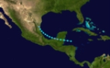
Hurricane Ten
Late on October 13, a minimal tropical storm formed in the western Caribbean Sea east-northeastBoxing the compass
Boxing the compass is the action of naming all thirty-two points of the compass in clockwise order. Such names are formed by the initials of the cardinal directions and their intermediate ordinal directions, and are very handy to refer to a heading in a general or colloquial fashion, without...
of northern Honduras. At the time, it was first detected when atmospheric pressures decreased over the Swan Islands
Swan Islands, Honduras
The Swan Islands, or Islas Santanilla, are a chain of three islands located in the northwestern Caribbean Sea, approximately ninety miles off the coastline of Honduras, with a land area of .-Detailed location and features:...
on October 14. It moved slowly west-northwest, and it gradually turned north on October 15. Late on October 15, it steadily intensified, and it attained hurricane intensity on October 17. On October 19, it strengthened to the equivalent of a major hurricane, and it struck the Pinar del Río Province
Pinar del Río Province
Pinar del Río is one of the provinces of Cuba. It is at the western end of the island of Cuba.-Geography:The Pinar del Río province is Cuba's westernmost province and contains one of Cuba's three main mountain ranges, the Cordillera de Guaniguanico, divided into the easterly Sierra del Rosario and...
of Cuba
Cuba
The Republic of Cuba is an island nation in the Caribbean. The nation of Cuba consists of the main island of Cuba, the Isla de la Juventud, and several archipelagos. Havana is the largest city in Cuba and the country's capital. Santiago de Cuba is the second largest city...
with sustained winds of at least 120 mph (195 km/h). A ship reported a minimum central pressure of 922 mbar (27.23 inHg) near Cayo Jutías, suggesting that the cyclone may have been stronger. On October 20, the hurricane turned east-northeast in response to the southward movement of a ridge
Ridge (meteorology)
A ridge is an elongated region of relatively high atmospheric pressure, the opposite of a trough....
, and it quickly weakened. Early on October 21, it struck Southwest Florida
Southwest Florida
Southwest Florida is a region of Florida , United States located along its gulf coast, south of the Tampa Bay area, west of Lake Okeechobee and mostly north of the Everglades...
near Naples
Naples, Florida
Naples is a city in Collier County, Florida, United States. As of July 1, 2007, the U.S. Census Bureau estimated the city's population at 21,653. Naples is a principal city of the Naples–Marco Island Metropolitan Statistical Area, which had an estimated total population of 315,839 on July 1, 2007...
, Florida
Florida
Florida is a state in the southeastern United States, located on the nation's Atlantic and Gulf coasts. It is bordered to the west by the Gulf of Mexico, to the north by Alabama and Georgia and to the east by the Atlantic Ocean. With a population of 18,801,310 as measured by the 2010 census, it...
as a Category 1 hurricane, and it entered the Atlantic Ocean
Atlantic Ocean
The Atlantic Ocean is the second-largest of the world's oceanic divisions. With a total area of about , it covers approximately 20% of the Earth's surface and about 26% of its water surface area...
north of Miami
Miami, Florida
Miami is a city located on the Atlantic coast in southeastern Florida and the county seat of Miami-Dade County, the most populous county in Florida and the eighth-most populous county in the United States with a population of 2,500,625...
with 70 mph (110 km/h) winds. The cyclone steadily weakened as it moved across the western Atlantic Ocean, and it dissipated west-southwest of Bermuda
Bermuda
Bermuda is a British overseas territory in the North Atlantic Ocean. Located off the east coast of the United States, its nearest landmass is Cape Hatteras, North Carolina, about to the west-northwest. It is about south of Halifax, Nova Scotia, Canada, and northeast of Miami, Florida...
on October 23. Following reanalysis released in March 2009, the storm was re-classified as a Category 5 with winds of 165 mph (270 km/h) and a minimum pressure of 910 mbar (hPa). This makes Hurricane Ten the earliest Category 5 recorded in the Atlantic Basin and ties it with Hurricane Ivan
Hurricane Ivan
Hurricane Ivan was a large, long-lived, Cape Verde-type hurricane that caused widespread damage in the Caribbean and United States. The cyclone was the ninth named storm, the sixth hurricane and the fourth major hurricane of the active 2004 Atlantic hurricane season...
for the 10th most intense storm ever recorded in the Atlantic.
In Cuba, at least 90 people were killed. The hurricane produced severe damage to crops and buildings across western Cuba, injuring 50–100 people in Arroyos de Mantua
Mantua, Cuba
Mantua is a municipality and city in the Pinar del Río Province of Cuba.It was founded in 1719 under the name Guane del Norte. In 1866 it was established as a municipality...
. In Key West
Key West, Florida
Key West is a city in Monroe County, Florida, United States. The city encompasses the island of Key West, the part of Stock Island north of U.S. 1 , Sigsbee Park , Fleming Key , and Sunset Key...
, peak gusts reached 66 mph (105 km/h) and damage was minimal to vegetation. In advance, watercraft were secured and trees were trimmed, reducing damages during the storm. The hurricane produced heavy precipitation across southern Florida, peaking at 23.22 inches (590 mm) on Marco Island. The rains caused flooding in Palm Beach County
Palm Beach County, Florida
Palm Beach County is the largest county in the state of Florida in total area, and third in population. As of 2010, the county's estimated population was 1,320,134, making it the twenty-eighth most populous in the United States...
, disrupting traffic on highways and railroads. The measured totals of 11.21 inches (112 mm) were believed to have been the highest rainfall in the county over the past 15 years. Peak gusts reached 68 mph (110 km/h) across the mainland of southern Florida, while sailing trips from southeastern Florida were cancelled. Telegraph wires were disabled in Fort Myers
Fort Myers, Florida
Fort Myers is the county seat and commercial center of Lee County, Florida, United States. Its population was 62,298 in the 2010 census, a 29.23 percent increase over the 2000 figure....
and Punta Gorda
Punta Gorda, Florida
Punta Gorda is a city in Charlotte County, Florida, United States. According to the U.S. Census Bureau estimates of 2007, the city had a population of 16,762. It is the county seat of Charlotte County and the only incorporated municipality in the county...
, though damages were minimal.
Hurricane Eleven
Early on November 5, a tropical storm formed in the southern CaribbeanCaribbean
The Caribbean is a crescent-shaped group of islands more than 2,000 miles long separating the Gulf of Mexico and the Caribbean Sea, to the west and south, from the Atlantic Ocean, to the east and north...
275 miles (445 km) north-northwest of Panama City
Panama City
Panama is the capital and largest city of the Republic of Panama. It has a population of 880,691, with a total metro population of 1,272,672, and it is located at the Pacific entrance of the Panama Canal, in the province of the same name. The city is the political and administrative center of the...
, Panama
Panama
Panama , officially the Republic of Panama , is the southernmost country of Central America. Situated on the isthmus connecting North and South America, it is bordered by Costa Rica to the northwest, Colombia to the southeast, the Caribbean Sea to the north and the Pacific Ocean to the south. The...
. Operationally, the cyclone was not detected until November 8, when observations indicated the presence of a circulation near Jamaica
Jamaica
Jamaica is an island nation of the Greater Antilles, in length, up to in width and 10,990 square kilometres in area. It is situated in the Caribbean Sea, about south of Cuba, and west of Hispaniola, the island harbouring the nation-states Haiti and the Dominican Republic...
. The system moved northward with winds of minimal intensity, and it struck Clarendon Parish, Jamaica
Clarendon Parish, Jamaica
Clarendon is a parish in Jamaica. It is located on the south of the island, roughly half-way between the island's eastern and western ends...
on November 7 with 40 mph (65 km/h) sustained winds. Early on November 8, it left the northern coast of the island, and it strengthened prior to making landfall west of Santiago de Cuba
Santiago de Cuba
Santiago de Cuba is the second largest city of Cuba and capital city of Santiago de Cuba Province in the south-eastern area of the island, some south-east of the Cuban capital of Havana....
on November 9. Later, the cyclone strengthened to a hurricane as it entered the Atlantic Ocean, and it turned northeast over the Turks and Caicos Islands
Turks and Caicos Islands
The Turks and Caicos Islands are a British Overseas Territory and overseas territory of the European Union consisting of two groups of tropical islands in the Caribbean, the larger Caicos Islands and the smaller Turks Islands, known for tourism and as an offshore financial centre.The Turks and...
on November 10. A ship reported hurricane force winds and a pressure of 996 mbar (29.40 inHg) near the center. On November 11, the hurricane accelerated as it left the Turks and Caicos Islands, and it attained a peak intensity of 100 mph (155 km/h). It maintained Category 2 status until November 13. The system weakened and passed east of Bermuda
Bermuda
Bermuda is a British overseas territory in the North Atlantic Ocean. Located off the east coast of the United States, its nearest landmass is Cape Hatteras, North Carolina, about to the west-northwest. It is about south of Halifax, Nova Scotia, Canada, and northeast of Miami, Florida...
, and it diminished to a tropical storm on November 14. It quickly became extratropical, and it was last reported on November 15.
See also
- List of tropical cyclones
- List of Atlantic hurricane seasons