
1924 Cuba hurricane
Encyclopedia
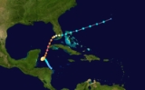
The 1924 Cuba hurricane is the earliest officially classified Category 5 Atlantic hurricane on the Saffir–Simpson scale
. It formed on October 14 in the western Caribbean Sea
, slowly organizing as it tracked northwestward. By October 16, it attained hurricane status to the east of the Yucatán Peninsula
, and subsequently executed a small counterclockwise loop. On October 18, the hurricane began undergoing rapid deepening
, and the next day it reached an estimated peak intensity of 165 miles per hour (270 kilometres per hour). Shortly thereafter, it struck extreme western Cuba at peak intensity, becoming the strongest hurricane on record to hit the country. Later the hurricane weakened greatly, striking southwestern Florida with winds of 90 mph (150 km/h) in a sparsely populated region. While crossing the state it weakened to tropical storm status, and after accelerating east-northeastward, it was absorbed by a cold front
on October 23 south of Bermuda.
Across the western Caribbean Sea, the developing storm produced heavy rainfall and increased winds. Strong winds in western Cuba caused severe damage, with two small towns nearly destroyed. About 90 people were killed in the country, all in Pinar Del Rio Province
. Later, the hurricane brought heavy rainfall to southern Florida, which caused flooding and crop damage. Damage was light in the state, and there were no casualties.
was first observed over the western Caribbean Sea
, just off the eastern Honduras coast. It was a large and weak tropical cyclone, moving slowly northwestward and gradually intensifying. On October 15, it is estimated the depression attained tropical storm status, and its strengthening became more steady. The next day, the storm reached hurricane status about 130 mi (215 km) southeast of Cozumel
, Quintana Roo
. Around that time, it began to execute a small counterclockwise loop off the east coast of the Yucatán Peninsula. By October 18 the hurricane completed the loop, during which its winds increased to 115 mph (185 km/h); this is the equivalence of a major hurricane
, or a Category 3 on the Saffir–Simpson Hurricane Scale. The estimation of its strength at this point was based on subsequent analysis of peripheral recordings of atmospheric pressure
and maximum sustained winds by ships and land stations.
Beginning late on October 18 as it tracked north-northeastward toward Cuba, the hurricane underwent rapid deepening
, evidenced by a ship wind report of 120 mph (193 km/h). This wind report was initially thought to be the peak intensity of the cyclone; however, subsequent research confirmed further deepening, based on very low pressures recorded across the region. A ship in the radius of maximum wind
s reported a reading of 922 mbar
; the barometer on the ship was found to be 5 mbar too high, resulting in a pressure of 917 mbar. Additionally, a station on land reported a pressure of 932 mbar (27.52 inHg). Based on the readings, the Hurricane Research Division
estimated the hurricane attained a minimum central pressure of 910 mbar very near the western coast of Cuba; this suggested peak winds of 165 mph (270 km/h). Late on October 19, the hurricane made landfall
in extreme western Cuba in Pinar del Río Province
. Dr. Jose C. Millas, director of the National Observatory at Havana, believed that "this hurricane [was] one of the most severe ever experienced in our latitudes."
After exiting Cuba into the Gulf of Mexico, the hurricane weakened greatly. On October 20 it passed a short distance west of Key West, Florida
, and very early on October 21 the hurricane moved over Marco Island
with winds of 90 mph (150 km/h). The cyclone weakened further as it turned eastward through the state, deteriorating to tropical storm status as it passed near or over Miami
. It accelerated east-northeastward, moving over the Abaco Islands
in The Bahamas
. Gradually weakening, the storm interacted with an approaching cold front
; late on October 23 it transitioned into an extratropical cyclone
, and shortly thereafter it was absorbed by the front.
, off the coast of Honduras. Heavy rainfall occurred throughout Jamaica, causing street flooding and several mudslides, but little damage. No disruptions were reported to communications or railway travel. The storm brushed eastern Belize while located off the coast, producing 3.62 inches (21.9 mm) of rainfall and light winds.
In extreme western Cuba, damage was very severe from the strong winds, likened to the impact of a tornado. Severe damage was reported in Los Arroyos and Arroyos de Mantua. In the latter location, around a dozen people were killed, 50 were injured, and nearly every building in the town was severely damaged; heavy losses also occurred to the tobacco crop. Across western Pinar del Rio Province
, the hurricane destroyed all communication links. Further from the center, the capital city of Havana
recorded southerly winds of 72 mph (116 km/h), as well as a minimum pressure of about 999 mbar (29.50 inHg). Around the country, the hurricane capsized several ships, primarily fishing vessels. The death toll in the country was estimated at around 90. In the days after the storm, Cuban President Zayas authorized about $30,000 in relief aid to send to hurricane victims in Pinar del Rio.
Several days prior to striking Florida, the outer circulation began producing rainfall across the state. Storm warnings
were issued along the east and west coastlines northward to Cedar Key
and Titusville
. Later, hurricane warnings were issued for much of the same area, and schools in the Tampa
area were closed as the storm was expected to move ashore. The hurricane first affected Florida when it passed west of Key West
, where sustained winds of 66 mph (107 km/h), along with gusts to 74 mph (120 km/h), were reported. Little damage occurred in the region, limited to downed trees; this was due to advanced warning by the U.S. Weather Bureau
, which advised ships to remain at port and for residents to secure property. Later, the hurricane moved ashore in a sparsely populated region of southwestern Florida. Damage was reported in Fort Myers and Punta Gorda and communications were temporarily cut, although no deaths were reported. Heavy rainfall was reported along its path, and one location accumulated 23.22 inches (590 mm) in a 24 hour period; this established a new one-day rainfall record in the state. A station in Miami recorded 12.18 inches (309 mm), and wind gusts in the area approached hurricane force. The combination of winds and rain damaged 5% of the local citrus and avocado crop. The rainfall flooded streets, homes, and commercial buildings in the Miami area, and hundreds of people were left without telephone access. No impact was reported in the Bahamas.
After a reanalysis of hurricanes between 1921 and 1925, the Hurricane Research Division
determined this hurricane attained winds of 165 mph (270 km/h), making it a Category 5 on the Saffir–Simpson Hurricane Scale. The hurricane is the earliest known to have attained the intensity, besting the 1928 Okeechobee hurricane
, which was previously thought to be the earliest storm of this intensity. It is also the only on record to make landfall
on Cuba at Category 5 status. A hurricane in 1846
that hit the country was also thought to have struck at Category 5 status, although the storm existed prior to the start of the Atlantic hurricane database. When the steamship "Toledo" recorded an atmospheric pressure
of 922 mbar (27.22 inHg) in the storm, it was the lowest pressure recorded in an Atlantic hurricane, breaking the previous record of 924 mbar (27.28 inHg) in the Atlantic hurricane of 1853. The record during this storm lasted until the 1932 Cuba hurricane
, when a pressure of 915 mbar (27.02 inHg) was reported. The reading of 932 mbar (27.52 inHg) at Los Arroyos in Mantua
, Pinar del Rio
remains the lowest pressure recorded on land in Cuba.
Saffir-Simpson Hurricane Scale
The Saffir–Simpson Hurricane Scale , or the Saffir–Simpson Hurricane Wind Scale , classifies hurricanes — Western Hemisphere tropical cyclones that exceed the intensities of tropical depressions and tropical storms — into five categories distinguished by the intensities of their sustained winds...
. It formed on October 14 in the western Caribbean Sea
Caribbean Sea
The Caribbean Sea is a sea of the Atlantic Ocean located in the tropics of the Western hemisphere. It is bounded by Mexico and Central America to the west and southwest, to the north by the Greater Antilles, and to the east by the Lesser Antilles....
, slowly organizing as it tracked northwestward. By October 16, it attained hurricane status to the east of the Yucatán Peninsula
Yucatán Peninsula
The Yucatán Peninsula, in southeastern Mexico, separates the Caribbean Sea from the Gulf of Mexico, with the northern coastline on the Yucatán Channel...
, and subsequently executed a small counterclockwise loop. On October 18, the hurricane began undergoing rapid deepening
Rapid deepening
Rapid deepening, also known as rapid intensification, is a meteorological condition that occurs when the minimum sea-level atmospheric pressure of a tropical cyclone decreases drastically in a short period of time. The National Weather Service describes rapid deepening as a decrease of...
, and the next day it reached an estimated peak intensity of 165 miles per hour (270 kilometres per hour). Shortly thereafter, it struck extreme western Cuba at peak intensity, becoming the strongest hurricane on record to hit the country. Later the hurricane weakened greatly, striking southwestern Florida with winds of 90 mph (150 km/h) in a sparsely populated region. While crossing the state it weakened to tropical storm status, and after accelerating east-northeastward, it was absorbed by a cold front
Cold front
A cold front is defined as the leading edge of a cooler mass of air, replacing a warmer mass of air.-Development of cold front:The cooler and denser air wedges under the less-dense warmer air, lifting it...
on October 23 south of Bermuda.
Across the western Caribbean Sea, the developing storm produced heavy rainfall and increased winds. Strong winds in western Cuba caused severe damage, with two small towns nearly destroyed. About 90 people were killed in the country, all in Pinar Del Rio Province
Pinar del Río Province
Pinar del Río is one of the provinces of Cuba. It is at the western end of the island of Cuba.-Geography:The Pinar del Río province is Cuba's westernmost province and contains one of Cuba's three main mountain ranges, the Cordillera de Guaniguanico, divided into the easterly Sierra del Rosario and...
. Later, the hurricane brought heavy rainfall to southern Florida, which caused flooding and crop damage. Damage was light in the state, and there were no casualties.
Meteorological history
On October 14, a tropical depressionTropical cyclone
A tropical cyclone is a storm system characterized by a large low-pressure center and numerous thunderstorms that produce strong winds and heavy rain. Tropical cyclones strengthen when water evaporated from the ocean is released as the saturated air rises, resulting in condensation of water vapor...
was first observed over the western Caribbean Sea
Caribbean Sea
The Caribbean Sea is a sea of the Atlantic Ocean located in the tropics of the Western hemisphere. It is bounded by Mexico and Central America to the west and southwest, to the north by the Greater Antilles, and to the east by the Lesser Antilles....
, just off the eastern Honduras coast. It was a large and weak tropical cyclone, moving slowly northwestward and gradually intensifying. On October 15, it is estimated the depression attained tropical storm status, and its strengthening became more steady. The next day, the storm reached hurricane status about 130 mi (215 km) southeast of Cozumel
Cozumel
Cozumel is an island in the Caribbean Sea off the eastern coast of Mexico's Yucatan Peninsula, opposite Playa del Carmen, and close to the Yucatan Channel. Cozumel is one of the ten municipalities of the state of Quintana Roo...
, Quintana Roo
Quintana Roo
Quintana Roo officially Estado Libre y Soberano de Quintana Roo is one of the 31 states which, with the Federal District, comprise the 32 Federal Entities of Mexico. It is divided in 10 municipalities and its capital city is Chetumal....
. Around that time, it began to execute a small counterclockwise loop off the east coast of the Yucatán Peninsula. By October 18 the hurricane completed the loop, during which its winds increased to 115 mph (185 km/h); this is the equivalence of a major hurricane
Tropical cyclone scales
Tropical systems are officially ranked on one of several tropical cyclone scales according to their maximum sustained winds and in what oceanic basin they are located...
, or a Category 3 on the Saffir–Simpson Hurricane Scale. The estimation of its strength at this point was based on subsequent analysis of peripheral recordings of atmospheric pressure
Atmospheric pressure
Atmospheric pressure is the force per unit area exerted into a surface by the weight of air above that surface in the atmosphere of Earth . In most circumstances atmospheric pressure is closely approximated by the hydrostatic pressure caused by the weight of air above the measurement point...
and maximum sustained winds by ships and land stations.
Beginning late on October 18 as it tracked north-northeastward toward Cuba, the hurricane underwent rapid deepening
Rapid deepening
Rapid deepening, also known as rapid intensification, is a meteorological condition that occurs when the minimum sea-level atmospheric pressure of a tropical cyclone decreases drastically in a short period of time. The National Weather Service describes rapid deepening as a decrease of...
, evidenced by a ship wind report of 120 mph (193 km/h). This wind report was initially thought to be the peak intensity of the cyclone; however, subsequent research confirmed further deepening, based on very low pressures recorded across the region. A ship in the radius of maximum wind
Radius of maximum wind
The radius of maximum wind is the distance between the center of a cyclone and its band of strongest winds. It is a parameter in atmospheric dynamics and tropical cyclone forecasting. The highest rainfall rates occur near the RMW of tropical cyclones. The extent of a cyclone's storm surge and...
s reported a reading of 922 mbar
Bar (unit)
The bar is a unit of pressure equal to 100 kilopascals, and roughly equal to the atmospheric pressure on Earth at sea level. Other units derived from the bar are the megabar , kilobar , decibar , centibar , and millibar...
; the barometer on the ship was found to be 5 mbar too high, resulting in a pressure of 917 mbar. Additionally, a station on land reported a pressure of 932 mbar (27.52 inHg). Based on the readings, the Hurricane Research Division
Hurricane Research Division
The Hurricane Research Division is a section of the Atlantic Oceanographic and Meteorological Laboratory in Miami, Florida, and is the National Oceanic and Atmospheric Administration's focus for tropical cyclone research...
estimated the hurricane attained a minimum central pressure of 910 mbar very near the western coast of Cuba; this suggested peak winds of 165 mph (270 km/h). Late on October 19, the hurricane made landfall
Landfall (meteorology)
Landfall is the event of a tropical cyclone or a waterspout coming onto land after being over water. When a waterspout makes landfall it is reclassified as a tornado, which can then cause damage inland...
in extreme western Cuba in Pinar del Río Province
Pinar del Río Province
Pinar del Río is one of the provinces of Cuba. It is at the western end of the island of Cuba.-Geography:The Pinar del Río province is Cuba's westernmost province and contains one of Cuba's three main mountain ranges, the Cordillera de Guaniguanico, divided into the easterly Sierra del Rosario and...
. Dr. Jose C. Millas, director of the National Observatory at Havana, believed that "this hurricane [was] one of the most severe ever experienced in our latitudes."
After exiting Cuba into the Gulf of Mexico, the hurricane weakened greatly. On October 20 it passed a short distance west of Key West, Florida
Key West, Florida
Key West is a city in Monroe County, Florida, United States. The city encompasses the island of Key West, the part of Stock Island north of U.S. 1 , Sigsbee Park , Fleming Key , and Sunset Key...
, and very early on October 21 the hurricane moved over Marco Island
Marco Island, Florida
Marco Island is a city in Collier County, Florida, United States, located on an island by the same name in the Gulf of Mexico off the coast of Southwest Florida. It is a principal city of the Naples–Marco Island Metropolitan Statistical Area...
with winds of 90 mph (150 km/h). The cyclone weakened further as it turned eastward through the state, deteriorating to tropical storm status as it passed near or over Miami
Miami, Florida
Miami is a city located on the Atlantic coast in southeastern Florida and the county seat of Miami-Dade County, the most populous county in Florida and the eighth-most populous county in the United States with a population of 2,500,625...
. It accelerated east-northeastward, moving over the Abaco Islands
Abaco Islands
The Abaco Islands lie in the northern Bahamas and comprise the main islands of Great Abaco and Little Abaco, together with the smaller Wood Cay, Elbow Cay, Lubbers Quarters Cay, Green Turtle Cay, Great Guana Cay, Castaway Cay, Man-o-War Cay, Stranger's Cay, Umbrella Cay, Walker's Cay, Little Grand...
in The Bahamas
The Bahamas
The Bahamas , officially the Commonwealth of the Bahamas, is a nation consisting of 29 islands, 661 cays, and 2,387 islets . It is located in the Atlantic Ocean north of Cuba and Hispaniola , northwest of the Turks and Caicos Islands, and southeast of the United States...
. Gradually weakening, the storm interacted with an approaching cold front
Cold front
A cold front is defined as the leading edge of a cooler mass of air, replacing a warmer mass of air.-Development of cold front:The cooler and denser air wedges under the less-dense warmer air, lifting it...
; late on October 23 it transitioned into an extratropical cyclone
Extratropical cyclone
Extratropical cyclones, sometimes called mid-latitude cyclones or wave cyclones, are a group of cyclones defined as synoptic scale low pressure weather systems that occur in the middle latitudes of the Earth having neither tropical nor polar characteristics, and are connected with fronts and...
, and shortly thereafter it was absorbed by the front.
Impact and records
As a developing tropical cyclone, the storm produced increased winds and lower pressures in the Swan IslandsSwan Islands, Honduras
The Swan Islands, or Islas Santanilla, are a chain of three islands located in the northwestern Caribbean Sea, approximately ninety miles off the coastline of Honduras, with a land area of .-Detailed location and features:...
, off the coast of Honduras. Heavy rainfall occurred throughout Jamaica, causing street flooding and several mudslides, but little damage. No disruptions were reported to communications or railway travel. The storm brushed eastern Belize while located off the coast, producing 3.62 inches (21.9 mm) of rainfall and light winds.
In extreme western Cuba, damage was very severe from the strong winds, likened to the impact of a tornado. Severe damage was reported in Los Arroyos and Arroyos de Mantua. In the latter location, around a dozen people were killed, 50 were injured, and nearly every building in the town was severely damaged; heavy losses also occurred to the tobacco crop. Across western Pinar del Rio Province
Pinar del Río Province
Pinar del Río is one of the provinces of Cuba. It is at the western end of the island of Cuba.-Geography:The Pinar del Río province is Cuba's westernmost province and contains one of Cuba's three main mountain ranges, the Cordillera de Guaniguanico, divided into the easterly Sierra del Rosario and...
, the hurricane destroyed all communication links. Further from the center, the capital city of Havana
Havana
Havana is the capital city, province, major port, and leading commercial centre of Cuba. The city proper has a population of 2.1 million inhabitants, and it spans a total of — making it the largest city in the Caribbean region, and the most populous...
recorded southerly winds of 72 mph (116 km/h), as well as a minimum pressure of about 999 mbar (29.50 inHg). Around the country, the hurricane capsized several ships, primarily fishing vessels. The death toll in the country was estimated at around 90. In the days after the storm, Cuban President Zayas authorized about $30,000 in relief aid to send to hurricane victims in Pinar del Rio.
Several days prior to striking Florida, the outer circulation began producing rainfall across the state. Storm warnings
Tropical cyclone warnings and watches
Warnings and watches are two levels of alert issued by national weather forecasting bodies to coastal areas threatened by the imminent approach of a tropical cyclone of tropical storm or hurricane intensity. They are notices to the local population and civil authorities to make appropriate...
were issued along the east and west coastlines northward to Cedar Key
Cedar Key, Florida
Cedar Key is a city in Levy County, Florida, United States. The population was 790 at the 2000 census. According to the U.S Census estimates of 2005, the city had a population of 958. The Cedar Keys are a cluster of islands close to the mainland. Most of the developed area of the city has been on...
and Titusville
Titusville, Florida
Titusville is a city in Brevard County, Florida in the United States. It is the county seat of Brevard County. Nicknamed Space City, USA, Titusville is on the Indian River, west of Merritt Island and the Kennedy Space Center and south-southwest of the Canaveral National Seashore...
. Later, hurricane warnings were issued for much of the same area, and schools in the Tampa
Tampa, Florida
Tampa is a city in the U.S. state of Florida. It serves as the county seat for Hillsborough County. Tampa is located on the west coast of Florida. The population of Tampa in 2010 was 335,709....
area were closed as the storm was expected to move ashore. The hurricane first affected Florida when it passed west of Key West
Key West, Florida
Key West is a city in Monroe County, Florida, United States. The city encompasses the island of Key West, the part of Stock Island north of U.S. 1 , Sigsbee Park , Fleming Key , and Sunset Key...
, where sustained winds of 66 mph (107 km/h), along with gusts to 74 mph (120 km/h), were reported. Little damage occurred in the region, limited to downed trees; this was due to advanced warning by the U.S. Weather Bureau
National Weather Service
The National Weather Service , once known as the Weather Bureau, is one of the six scientific agencies that make up the National Oceanic and Atmospheric Administration of the United States government...
, which advised ships to remain at port and for residents to secure property. Later, the hurricane moved ashore in a sparsely populated region of southwestern Florida. Damage was reported in Fort Myers and Punta Gorda and communications were temporarily cut, although no deaths were reported. Heavy rainfall was reported along its path, and one location accumulated 23.22 inches (590 mm) in a 24 hour period; this established a new one-day rainfall record in the state. A station in Miami recorded 12.18 inches (309 mm), and wind gusts in the area approached hurricane force. The combination of winds and rain damaged 5% of the local citrus and avocado crop. The rainfall flooded streets, homes, and commercial buildings in the Miami area, and hundreds of people were left without telephone access. No impact was reported in the Bahamas.
After a reanalysis of hurricanes between 1921 and 1925, the Hurricane Research Division
Hurricane Research Division
The Hurricane Research Division is a section of the Atlantic Oceanographic and Meteorological Laboratory in Miami, Florida, and is the National Oceanic and Atmospheric Administration's focus for tropical cyclone research...
determined this hurricane attained winds of 165 mph (270 km/h), making it a Category 5 on the Saffir–Simpson Hurricane Scale. The hurricane is the earliest known to have attained the intensity, besting the 1928 Okeechobee hurricane
1928 Okeechobee Hurricane
The Okeechobee hurricane, or San Felipe Segundo hurricane, was a deadly hurricane that struck the Leeward Islands, Puerto Rico, the Bahamas, and Florida in September of the 1928 Atlantic hurricane season...
, which was previously thought to be the earliest storm of this intensity. It is also the only on record to make landfall
Landfall (meteorology)
Landfall is the event of a tropical cyclone or a waterspout coming onto land after being over water. When a waterspout makes landfall it is reclassified as a tornado, which can then cause damage inland...
on Cuba at Category 5 status. A hurricane in 1846
Great Havana Hurricane of 1846
The Great Havana Hurricane of 1846 was a powerful late season hurricane that caused extensive damage and up to 255 deaths as it moved across Cuba, Florida, and the eastern United States before dissipating over the Canadian Maritimes.-Meteorological history:...
that hit the country was also thought to have struck at Category 5 status, although the storm existed prior to the start of the Atlantic hurricane database. When the steamship "Toledo" recorded an atmospheric pressure
Atmospheric pressure
Atmospheric pressure is the force per unit area exerted into a surface by the weight of air above that surface in the atmosphere of Earth . In most circumstances atmospheric pressure is closely approximated by the hydrostatic pressure caused by the weight of air above the measurement point...
of 922 mbar (27.22 inHg) in the storm, it was the lowest pressure recorded in an Atlantic hurricane, breaking the previous record of 924 mbar (27.28 inHg) in the Atlantic hurricane of 1853. The record during this storm lasted until the 1932 Cuba hurricane
1932 Cuba Hurricane
The 1932 Cuba hurricane was a powerful and deadly late-season hurricane during the 1932 Atlantic hurricane season. It was the tenth tropical storm, fifth hurricane and fourth major hurricane of the 1932 season...
, when a pressure of 915 mbar (27.02 inHg) was reported. The reading of 932 mbar (27.52 inHg) at Los Arroyos in Mantua
Mantua, Cuba
Mantua is a municipality and city in the Pinar del Río Province of Cuba.It was founded in 1719 under the name Guane del Norte. In 1866 it was established as a municipality...
, Pinar del Rio
Pinar del Río Province
Pinar del Río is one of the provinces of Cuba. It is at the western end of the island of Cuba.-Geography:The Pinar del Río province is Cuba's westernmost province and contains one of Cuba's three main mountain ranges, the Cordillera de Guaniguanico, divided into the easterly Sierra del Rosario and...
remains the lowest pressure recorded on land in Cuba.