
Yulupa Creek
Encyclopedia
Yulupa Creek is a 2.8 miles (4.5 km) southeast-flowing perennial stream
that rises on the southeastern flanks of the northern Sonoma Mountains
in Sonoma County, California
, United States
. This creek, which drains the eastern slopes of Bennett Mountain
, is tributary
to Sonoma Creek
, which in turn discharges to San Pablo Bay
.
near Bennett Ridge Road. It descends initially to the southeast. After about 2 miles (3 km) it meets Bennett Valley Road, which it follows eastward to Warm Springs Road, where it discharges into Sonoma Creek.
comprises an area of approximately five square miles, and is considered a viable steelhead, Oncorhynchus mykiss, spawning
habitat
; stream surveys conducted from 1966 to 1986 indicated significant, but declining population
s of anadromous fish. NOAA fisheries has designated the Yulupa Creek watershed as "Critical Habitat" for Oncorhychus mykiss as well as O. tshawytscha (Chinook Salmon
) as of 2004.
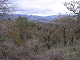
Land use
in this watershed consists of Annadel State Park
usage and very low density rural single family residential development, much of which is upmarket housing stock. From the higher headwater elevations, there are expansive views of Hood Mountain
and the southern Mayacamas Mountains can be seen to the north; Sonoma Valley
and distantly San Francisco to the south; and Sonoma Mountain
to the southwest. The area designation of most of this watershed is Kenwood, California
, an unincorporated area known for its viticulture
, although only a small fraction of the Yulupa Creek watershed is planted to grape
s.
 In addition to known spawning area for O. mykiss, Yulupa Creek has been designated as a high quality riparian zone
and an identified habitat of freshwater shrimp
. Moreover, the upland watershed area is a California oak woodland
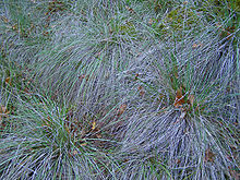
, much of which is a relatively undisturbed ecosystem with considerable biodiversity
. These forested areas have been characterized as some of the best examples of such woodlands. An unusual characteristic of these forests is the high content of undisturbed prehistoric bunch grass understory, testifying to the absence of historic grazing
or other agriculture
.
Besides the riparian habitat, plant communities include California oak woodland
, Douglas fir forest
, chaparral
, grassland
and marsh
. The dominant plant community is the oak woodland, which has a canopy
of coast live oak
, Garry oak
, Black oak, Pacific Madrone
, Bigleaf maple
and California laurel. Occasionally in the vicinity of drainage swale
s and creek
s, Canyon live oak is found. In the oak woodlands, the dominant understory
plants are native bunch grass, toyon
, blackberry
, western poison-oak
and in drier patches coyote brush. Common animals observed include Black-tailed Deer
, gray squirrel
, raccoon
, skunk
and opossum. Less frequently bobcat
and mountain lion are seen. There is abundant bird
life including the scrub jay, Steller's jay
, Acorn woodpecker
, Black Phoebe
and junco
. A number of amphibian
s occur near the creek and its tributary elements, including the Rough skinned newt, Taricha granulosa.
 Many of Yulupa Creek's high headwater tributaries are dry in the summer, since rainfall is highly seasonal, with most of the approximately 30 in (76.2 cm) of annual precipitation
occurring between the months of October and April: however, Ledson Marsh
retains some smaller pools of water throughout most of the year. Ledson Marsh has a southern outlet to the north fork of Yulupa Creek.
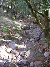
The Yulupa Creek watershed was below the Pacific Ocean
floor as recently as the Miocene
era, around which time massive uplift
and volcanic
action formed the massif
which comprises the headwaters higher elevations of the watershed of today. Elevations within the drainage basin of Yulupa Creek range from about 430 to 1800 feet (130 to 550 meters) above sea level. Sandstone
is the dominant rock type, as a remnant of the ancient sea floor. Slopes within the headwaters area commonly range from 15 to 30 percent, and lower reaches have gradients of two to five percent. One of the major soil associations within the upper elevation riparian zone is Goulding cobbly clay
loam
, which contains roughly 25 percent cobblestone
s, as well as some basalt
ic exposures, betraying the volcanic past of the Sonoma Mountains
formation. Typical soil depths in the headwater area range from 14 to 20 inches (35 to 50 centimeters). Much of the soil type in the Yulupa Creek riparian zone
consists of Laniger loam, with rhyolite
outcrops, another relic of the igneous history.
 There are two significant public roadway bridge
s across Yulupa Creek. The lowermost traverses the creek on Warm Springs Road, 11.15 miles (17.94 km) north of State Route 116
; this seven meter span was constructed in the year 1930 with a concrete culvert design using frame culvert construction. A second crossing farther upstream is the traversal of Bennett Valley Road at a point 0.6 miles (1 km) west of Warm Springs Road; this year 1970 bridge is of concrete slab construction, with a span of 33 feet (10.1 meters).
Perennial stream
A perennial stream or perennial river is a stream or river that has continuous flow in parts of its bed all year round during years of normal rainfall. "Perennial" streams are contrasted with "intermittent" streams which normally cease flowing for weeks or months each year, and with "ephemeral"...
that rises on the southeastern flanks of the northern Sonoma Mountains
Sonoma Mountains
The Sonoma Mountains are a northwest-southeast trending formation of California Coast Ranges in Sonoma County, California, USA. The range is approximately fourteen miles long and separates the Sonoma Creek watershed from the Petaluma River and Tolay Creek watersheds...
in Sonoma County, California
Sonoma County, California
Sonoma County, located on the northern coast of the U.S. state of California, is the largest and northernmost of the nine San Francisco Bay Area counties. Its population at the 2010 census was 483,878. Its largest city and county seat is Santa Rosa....
, United States
United States
The United States of America is a federal constitutional republic comprising fifty states and a federal district...
. This creek, which drains the eastern slopes of Bennett Mountain
Bennett Mountain
Bennett Mountain is a summit in the Sonoma Mountains of California. Located on the west edge of Annadel State Park, it separates Bennett Valley in the Russian River drainage basin from Sonoma Valley in the Sonoma Creek drainage basin....
, is tributary
Tributary
A tributary or affluent is a stream or river that flows into a main stem river or a lake. A tributary does not flow directly into a sea or ocean...
to Sonoma Creek
Sonoma Creek
Sonoma Creek is a stream in northern California. It is one of two principal drainages of southern Sonoma County, California, with headwaters rising in the rugged hills of Sugarloaf Ridge State Park and discharging to San Pablo Bay, the northern arm of San Francisco Bay. The watershed drained by...
, which in turn discharges to San Pablo Bay
San Pablo Bay
San Pablo Bay is a tidal estuary that forms the northern extension of San Francisco Bay in northern California in the United States. Most of the Bay is shallow; however, there is a deep water channel approximately in mid bay, which allows access to Sacramento, Stockton, Benicia, Martinez, and...
.
Course
Yulupa Creek rises in the Sonoma Mountains, on the southwestern edge of Annadel State ParkAnnadel State Park
Annadel State Park is a state park of California, USA, situated at the northern edge of Sonoma Valley and offering many recreational activities within its property...
near Bennett Ridge Road. It descends initially to the southeast. After about 2 miles (3 km) it meets Bennett Valley Road, which it follows eastward to Warm Springs Road, where it discharges into Sonoma Creek.
Watershed
The Yulupa Creek watershedDrainage basin
A drainage basin is an extent or an area of land where surface water from rain and melting snow or ice converges to a single point, usually the exit of the basin, where the waters join another waterbody, such as a river, lake, reservoir, estuary, wetland, sea, or ocean...
comprises an area of approximately five square miles, and is considered a viable steelhead, Oncorhynchus mykiss, spawning
Spawn (biology)
Spawn refers to the eggs and sperm released or deposited, usually into water, by aquatic animals. As a verb, spawn refers to the process of releasing the eggs and sperm, also called spawning...
habitat
Habitat
* Habitat , a place where a species lives and grows*Human habitat, a place where humans live, work or play** Space habitat, a space station intended as a permanent settlement...
; stream surveys conducted from 1966 to 1986 indicated significant, but declining population
Population
A population is all the organisms that both belong to the same group or species and live in the same geographical area. The area that is used to define a sexual population is such that inter-breeding is possible between any pair within the area and more probable than cross-breeding with individuals...
s of anadromous fish. NOAA fisheries has designated the Yulupa Creek watershed as "Critical Habitat" for Oncorhychus mykiss as well as O. tshawytscha (Chinook Salmon
Chinook salmon
The Chinook salmon, Oncorhynchus tshawytscha, is the largest species in the pacific salmon family. Other commonly used names for the species include King salmon, Quinnat salmon, Spring salmon and Tyee salmon...
) as of 2004.
Land use
Land use
Land use is the human use of land. Land use involves the management and modification of natural environment or wilderness into built environment such as fields, pastures, and settlements. It has also been defined as "the arrangements, activities and inputs people undertake in a certain land cover...
in this watershed consists of Annadel State Park
Annadel State Park
Annadel State Park is a state park of California, USA, situated at the northern edge of Sonoma Valley and offering many recreational activities within its property...
usage and very low density rural single family residential development, much of which is upmarket housing stock. From the higher headwater elevations, there are expansive views of Hood Mountain
Hood Mountain
Mount Hood, also known as Hood Mountain is a mountain near the southeastern edge of Santa Rosa, California at the northeast of the Sonoma Valley and attains a height of . The originally name was Mount Wilikos, an Indian name meaning "willows."...
and the southern Mayacamas Mountains can be seen to the north; Sonoma Valley
Sonoma Valley
Sonoma Valley is the birthplace of the California wine industry and often called The Valley of the Moon. Sonoma Valley is home to some of the earliest vineyards and wineries in the state, some of which survived the phylloxera epidemic of the 1870s and the impact of Prohibition...
and distantly San Francisco to the south; and Sonoma Mountain
Sonoma Mountain
Sonoma Mountain is a prominent landform within the Sonoma Mountains of southern Sonoma County, California. At elevation of , Sonoma Mountain offers expansive views of the Pacific Ocean to the west and the Sonoma Valley to the east...
to the southwest. The area designation of most of this watershed is Kenwood, California
Kenwood, California
Kenwood, California is an unincorporated town and census-designated place in Sonoma County, California, United States, located on Sonoma Highway between the cities Santa Rosa and Sonoma. It lies east of Sonoma Creek in the upper part of Sonoma Valley, a region sometimes called the Valley of the...
, an unincorporated area known for its viticulture
Viticulture
Viticulture is the science, production and study of grapes which deals with the series of events that occur in the vineyard. When the grapes are used for winemaking, it is also known as viniculture...
, although only a small fraction of the Yulupa Creek watershed is planted to grape
Grape
A grape is a non-climacteric fruit, specifically a berry, that grows on the perennial and deciduous woody vines of the genus Vitis. Grapes can be eaten raw or they can be used for making jam, juice, jelly, vinegar, wine, grape seed extracts, raisins, molasses and grape seed oil. Grapes are also...
s.
Flora and fauna
Riparian zone
A riparian zone or riparian area is the interface between land and a river or stream. Riparian is also the proper nomenclature for one of the fifteen terrestrial biomes of the earth. Plant habitats and communities along the river margins and banks are called riparian vegetation, characterized by...
and an identified habitat of freshwater shrimp
Syncaris pacifica
Syncaris pacifica is an endangered species of freshwater shrimp in the family Atyidae that occurs only in a limited range within the northern San Francisco Bay Area, California, USA. Specifically, this species occurs only in 17 stream segments within Sonoma, Napa and Marin Counties...
. Moreover, the upland watershed area is a California oak woodland
California oak woodland
California oak woodland is a plant community found throughout the California chaparral and woodlands ecoregion of California in the United States and northwestern Baja California in Mexico...
, much of which is a relatively undisturbed ecosystem with considerable biodiversity
Biodiversity
Biodiversity is the degree of variation of life forms within a given ecosystem, biome, or an entire planet. Biodiversity is a measure of the health of ecosystems. Biodiversity is in part a function of climate. In terrestrial habitats, tropical regions are typically rich whereas polar regions...
. These forested areas have been characterized as some of the best examples of such woodlands. An unusual characteristic of these forests is the high content of undisturbed prehistoric bunch grass understory, testifying to the absence of historic grazing
Grazing
Grazing generally describes a type of feeding, in which a herbivore feeds on plants , and also on other multicellular autotrophs...
or other agriculture
Agriculture
Agriculture is the cultivation of animals, plants, fungi and other life forms for food, fiber, and other products used to sustain life. Agriculture was the key implement in the rise of sedentary human civilization, whereby farming of domesticated species created food surpluses that nurtured the...
.
Besides the riparian habitat, plant communities include California oak woodland
California oak woodland
California oak woodland is a plant community found throughout the California chaparral and woodlands ecoregion of California in the United States and northwestern Baja California in Mexico...
, Douglas fir forest
Forest
A forest, also referred to as a wood or the woods, is an area with a high density of trees. As with cities, depending where you are in the world, what is considered a forest may vary significantly in size and have various classification according to how and what of the forest is composed...
, chaparral
Chaparral
Chaparral is a shrubland or heathland plant community found primarily in the U.S. state of California and in the northern portion of the Baja California peninsula, Mexico...
, grassland
Grassland
Grasslands are areas where the vegetation is dominated by grasses and other herbaceous plants . However, sedge and rush families can also be found. Grasslands occur naturally on all continents except Antarctica...
and marsh
Marsh
In geography, a marsh, or morass, is a type of wetland that is subject to frequent or continuous flood. Typically the water is shallow and features grasses, rushes, reeds, typhas, sedges, other herbaceous plants, and moss....
. The dominant plant community is the oak woodland, which has a canopy
Canopy (forest)
In biology, the canopy is the aboveground portion of a plant community or crop, formed by plant crowns.For forests, canopy also refers to the upper layer or habitat zone, formed by mature tree crowns and including other biological organisms .Sometimes the term canopy is used to refer to the extent...
of coast live oak
Coast Live Oak
Quercus agrifolia, the Coast Live Oak, is an evergreen oak , native to the California Floristic Province. It grows west of the Sierra Nevada from Mendocino County, California, south to northern Baja California in Mexico. It is classified in the red oak section Quercus agrifolia, the Coast Live Oak,...
, Garry oak
Garry Oak
Quercus garryana, the Garry Oak, Oregon White Oak or Oregon Oak, has a range from southern California to extreme southwestern British Columbia, particularly southeastern Vancouver Island and the adjacent Gulf Islands. It grows from sea level to 210 m altitude in the northern part of its range, and...
, Black oak, Pacific Madrone
Pacific Madrone
Arbutus menziesii, commonly known as the Pacific Madrone, is a species of Arbutus found on the west coast of North America, from British Columbia to California...
, Bigleaf maple
Bigleaf Maple
Acer macrophyllum is a large deciduous tree in the genus Acer.It can grow to be up to 35 m tall, but more commonly grows 15 m to 20 m tall. It is native to western North America, mostly near the Pacific coast, from southernmost Alaska to southern California...
and California laurel. Occasionally in the vicinity of drainage swale
Swale
Swale is a local government district with borough status in Kent, England. Its council is based in Sittingbourne. The borough is named after the narrow channel called The Swale, a channel that separates the mainland of Kent from the Isle of Sheppey, and which occupies the central part of the...
s and creek
Stream
A stream is a body of water with a current, confined within a bed and stream banks. Depending on its locale or certain characteristics, a stream may be referred to as a branch, brook, beck, burn, creek, "crick", gill , kill, lick, rill, river, syke, bayou, rivulet, streamage, wash, run or...
s, Canyon live oak is found. In the oak woodlands, the dominant understory
Understory
Understory is the term for the area of a forest which grows at the lowest height level below the forest canopy. Plants in the understory consist of a mixture of seedlings and saplings of canopy trees together with understory shrubs and herbs...
plants are native bunch grass, toyon
Toyon
Heteromeles arbutifolia , and commonly known as Toyon, is a common perennial shrub native to California down to Baja California....
, blackberry
Blackberry
The blackberry is an edible fruit produced by any of several species in the Rubus genus of the Rosaceae family. The fruit is not a true berry; botanically it is termed an aggregate fruit, composed of small drupelets. The plants typically have biennial canes and perennial roots. Blackberries and...
, western poison-oak
Western Poison-oak
Toxicodendron diversilobum, western poison oak or Pacific poison-oak is in the Anacardiaceae family and is a plant best known for its ability to cause allergic rashes after contact...
and in drier patches coyote brush. Common animals observed include Black-tailed Deer
Black-tailed Deer
Two forms of black-tailed deer or blacktail deer occupying coastal temperate rainforest on North America's Pacific coast are subspecies of the mule deer. They have sometimes been treated as a species, but virtually all recent authorities maintain they are subspecies...
, gray squirrel
Gray squirrel
Gray squirrel or grey squirrel may refer to several species of squirrel indigenous to North America:*The Eastern gray squirrel , from the eastern United States and southeastern Canada; introduced into Britain, Ireland, western North America, Italy, and South Africa;*The Western Gray Squirrel , from...
, raccoon
Raccoon
Procyon is a genus of nocturnal mammals, comprising three species commonly known as raccoons, in the family Procyonidae. The most familiar species, the common raccoon , is often known simply as "the" raccoon, as the two other raccoon species in the genus are native only to the tropics and are...
, skunk
Skunk
Skunks are mammals best known for their ability to secrete a liquid with a strong, foul odor. General appearance varies from species to species, from black-and-white to brown or cream colored. Skunks belong to the family Mephitidae and to the order Carnivora...
and opossum. Less frequently bobcat
Bobcat
The bobcat is a North American mammal of the cat family Felidae, appearing during the Irvingtonian stage of around 1.8 million years ago . With twelve recognized subspecies, it ranges from southern Canada to northern Mexico, including most of the continental United States...
and mountain lion are seen. There is abundant bird
Bird
Birds are feathered, winged, bipedal, endothermic , egg-laying, vertebrate animals. Around 10,000 living species and 188 families makes them the most speciose class of tetrapod vertebrates. They inhabit ecosystems across the globe, from the Arctic to the Antarctic. Extant birds range in size from...
life including the scrub jay, Steller's jay
Steller's Jay
The Steller's Jay is a jay native to western North America, closely related to the Blue Jay found in the rest of the continent, but with a black head and upper body. It is also known as the Long-crested Jay, Mountain Jay, and Pine Jay...
, Acorn woodpecker
Acorn Woodpecker
The Acorn woodpecker is a medium-sized woodpecker, 21 cm long with an average weight of 85 g.-Description:...
, Black Phoebe
Black Phoebe
The Black Phoebe, Sayornis nigricans, is a passerine bird in the tyrant-flycatcher family. It breeds from southwest Oregon and California south through Central and South America. It occurs year-round throughout most of its range and migrates less than the other birds in its genus, though its...
and junco
Junco
A Junco , genus Junco, is a small North American bird. Junco systematics are still confusing after decades of research, with various authors accepting between three and twelve species...
. A number of amphibian
Amphibian
Amphibians , are a class of vertebrate animals including animals such as toads, frogs, caecilians, and salamanders. They are characterized as non-amniote ectothermic tetrapods...
s occur near the creek and its tributary elements, including the Rough skinned newt, Taricha granulosa.
Geology
Precipitation (meteorology)
In meteorology, precipitation In meteorology, precipitation In meteorology, precipitation (also known as one of the classes of hydrometeors, which are atmospheric water phenomena is any product of the condensation of atmospheric water vapor that falls under gravity. The main forms of precipitation...
occurring between the months of October and April: however, Ledson Marsh
Ledson Marsh
Ledson Marsh is a freshwater marsh in Annadel State Park east of Santa Rosa in Sonoma County, California, United States. Located on the east flank of Bennett Mountain, it drains into Schultz Creek, a tributary of Yulupa Creek....
retains some smaller pools of water throughout most of the year. Ledson Marsh has a southern outlet to the north fork of Yulupa Creek.
The Yulupa Creek watershed was below the Pacific Ocean
Pacific Ocean
The Pacific Ocean is the largest of the Earth's oceanic divisions. It extends from the Arctic in the north to the Southern Ocean in the south, bounded by Asia and Australia in the west, and the Americas in the east.At 165.2 million square kilometres in area, this largest division of the World...
floor as recently as the Miocene
Miocene
The Miocene is a geological epoch of the Neogene Period and extends from about . The Miocene was named by Sir Charles Lyell. Its name comes from the Greek words and and means "less recent" because it has 18% fewer modern sea invertebrates than the Pliocene. The Miocene follows the Oligocene...
era, around which time massive uplift
Tectonic uplift
Tectonic uplift is a geological process most often caused by plate tectonics which increases elevation. The opposite of uplift is subsidence, which results in a decrease in elevation. Uplift may be orogenic or isostatic.-Orogenic uplift:...
and volcanic
Volcano
2. Bedrock3. Conduit 4. Base5. Sill6. Dike7. Layers of ash emitted by the volcano8. Flank| 9. Layers of lava emitted by the volcano10. Throat11. Parasitic cone12. Lava flow13. Vent14. Crater15...
action formed the massif
Massif
In geology, a massif is a section of a planet's crust that is demarcated by faults or flexures. In the movement of the crust, a massif tends to retain its internal structure while being displaced as a whole...
which comprises the headwaters higher elevations of the watershed of today. Elevations within the drainage basin of Yulupa Creek range from about 430 to 1800 feet (130 to 550 meters) above sea level. Sandstone
Sandstone
Sandstone is a sedimentary rock composed mainly of sand-sized minerals or rock grains.Most sandstone is composed of quartz and/or feldspar because these are the most common minerals in the Earth's crust. Like sand, sandstone may be any colour, but the most common colours are tan, brown, yellow,...
is the dominant rock type, as a remnant of the ancient sea floor. Slopes within the headwaters area commonly range from 15 to 30 percent, and lower reaches have gradients of two to five percent. One of the major soil associations within the upper elevation riparian zone is Goulding cobbly clay
Clay
Clay is a general term including many combinations of one or more clay minerals with traces of metal oxides and organic matter. Geologic clay deposits are mostly composed of phyllosilicate minerals containing variable amounts of water trapped in the mineral structure.- Formation :Clay minerals...
loam
Loam
Loam is soil composed of sand, silt, and clay in relatively even concentration . Loam soils generally contain more nutrients and humus than sandy soils, have better infiltration and drainage than silty soils, and are easier to till than clay soils...
, which contains roughly 25 percent cobblestone
Cobblestone
Cobblestones are stones that were frequently used in the pavement of early streets. "Cobblestone" is derived from the very old English word "cob", which had a wide range of meanings, one of which was "rounded lump" with overtones of large size...
s, as well as some basalt
Basalt
Basalt is a common extrusive volcanic rock. It is usually grey to black and fine-grained due to rapid cooling of lava at the surface of a planet. It may be porphyritic containing larger crystals in a fine matrix, or vesicular, or frothy scoria. Unweathered basalt is black or grey...
ic exposures, betraying the volcanic past of the Sonoma Mountains
Sonoma Mountains
The Sonoma Mountains are a northwest-southeast trending formation of California Coast Ranges in Sonoma County, California, USA. The range is approximately fourteen miles long and separates the Sonoma Creek watershed from the Petaluma River and Tolay Creek watersheds...
formation. Typical soil depths in the headwater area range from 14 to 20 inches (35 to 50 centimeters). Much of the soil type in the Yulupa Creek riparian zone
Riparian zone
A riparian zone or riparian area is the interface between land and a river or stream. Riparian is also the proper nomenclature for one of the fifteen terrestrial biomes of the earth. Plant habitats and communities along the river margins and banks are called riparian vegetation, characterized by...
consists of Laniger loam, with rhyolite
Rhyolite
This page is about a volcanic rock. For the ghost town see Rhyolite, Nevada, and for the satellite system, see Rhyolite/Aquacade.Rhyolite is an igneous, volcanic rock, of felsic composition . It may have any texture from glassy to aphanitic to porphyritic...
outcrops, another relic of the igneous history.
Bridges
Bridge
A bridge is a structure built to span physical obstacles such as a body of water, valley, or road, for the purpose of providing passage over the obstacle...
s across Yulupa Creek. The lowermost traverses the creek on Warm Springs Road, 11.15 miles (17.94 km) north of State Route 116
California State Route 116
State Route 116 is a state highway in the U.S. state of California in Sonoma County. The route runs from State Route 1 on the Pacific coast near Jenner to State Route 121 south of Sonoma.-Route description:...
; this seven meter span was constructed in the year 1930 with a concrete culvert design using frame culvert construction. A second crossing farther upstream is the traversal of Bennett Valley Road at a point 0.6 miles (1 km) west of Warm Springs Road; this year 1970 bridge is of concrete slab construction, with a span of 33 feet (10.1 meters).
See also
- Annadel State ParkAnnadel State ParkAnnadel State Park is a state park of California, USA, situated at the northern edge of Sonoma Valley and offering many recreational activities within its property...
- Graham CreekGraham CreekGraham Creek is a perennial stream in Sonoma County, California, tributary to Sonoma Creek. Graham Creek rises in the northern Sonoma Mountains and flows generally northeasterly down the northeastern flank of Sonoma Mountain. Historically this watercourse was called Wild Water Creek, a name used...
- List of watercourses in the San Francisco Bay Area
- Pomo peoplePomo peopleThe Pomo people are an indigenous peoples of California. The historic Pomo territory in northern California was large, bordered by the Pacific Coast to the west, extending inland to Clear Lake, and mainly between Cleone and Duncans Point...
- Taylor Mountain