
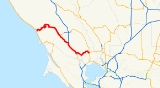
California State Route 116
Encyclopedia
State Route 116 is a state highway
in the U.S. state
of California
in Sonoma County
. The route runs from State Route 1
on the Pacific coast
near Jenner
to State Route 121
south of Sonoma
.
and is eligible for the State Scenic Highway System
. However, it is only a scenic highway as designated by Caltrans from SR 1 to the Sebastopol city limit.
State Route 116 proceeds east along the north bank of the Russian River
, from State Route 1 to Guerneville
, passing through Duncans Mills
, Monte Rio
, and Guernewood Park
. In this section, it is generally called River Road.
At Guerneville, the route turns south-east and passes through Forestville
, Graton
, and Sebastopol
(where it intersects State Route 12) to join U.S. Route 101
in Cotati
. In this section, it is generally called Guerneville Highway or Gravenstein Highway.
 The route follows the U.S. 101 alignment south from Cotati to Petaluma
, a stretch Caltrans calls the Cotati Grade.
From southern Petaluma, State Route 116 diverges from 101 and heads east again, crossing the Sonoma Mountains
directly north of Tolay Lake
and descending into the Sonoma Valley
to its terminus at State Route 121
. In this section, it goes by several names: Lakeville Highway, Stage Gulch Road, and Arnold Drive.
The entire route is in Sonoma County
.
{| class=wikitable
!Location
!Postmile
!Exit
!Destinations
!Notes
|-
|
|0.00
|
|
|
|-
|Guerneville
|
|
|River Road – Rio Nido
|
|-
|
|21.80
|
|Guerneville Road – Santa Rosa
|
|-
|Sebastopol
|R26.73-R26.82
|
|
|
|-
|rowspan=3|Cotati
|bgcolor=#ddffdd|35.03
12.69Indicates that the postmile represents the distance along US 101 rather than SR 116.
|bgcolor=#ddffdd|
|bgcolor=#ddffdd|
|bgcolor=#ddffdd|Interchange; west end of US 101 overlap
|-
|colspan=4 align=center|West end of freeway on US 101
|-
|12.00
|481A
|West Sierra Avenue – Cotati
|
|-
|
|10.67
|479
|Railroad Avenue
|
|-
|rowspan=4|Petaluma
|5.76
|476
|Old Redwood Highway, Petaluma Boulevard North (US 101 Bus. south) – Penngrove
|
|-
|4.76
|474
|East Washington Street – Central Petaluma
|
|-
|colspan=4 align=center|East end of freeway on US 101
|-bgcolor=#ddffdd
|3.58
35.04
|
|
|Interchange; east end of US 101 overlap
|-
|
|39.27
|
|Lakeville Road – Lakeville
, Vallejo
|
|-
|
|44.84
|
|Arnold Drive – Sonoma
|
|-
|
|46.75
|
|
|
State highway
State highway, state road or state route can refer to one of three related concepts, two of them related to a state or provincial government in a country that is divided into states or provinces :#A...
in the U.S. state
U.S. state
A U.S. state is any one of the 50 federated states of the United States of America that share sovereignty with the federal government. Because of this shared sovereignty, an American is a citizen both of the federal entity and of his or her state of domicile. Four states use the official title of...
of California
California
California is a state located on the West Coast of the United States. It is by far the most populous U.S. state, and the third-largest by land area...
in Sonoma County
Sonoma County, California
Sonoma County, located on the northern coast of the U.S. state of California, is the largest and northernmost of the nine San Francisco Bay Area counties. Its population at the 2010 census was 483,878. Its largest city and county seat is Santa Rosa....
. The route runs from State Route 1
California State Route 1
State Route 1 , more often called Highway 1, is a state highway that runs along much of the Pacific coast of the U.S. state of California. It is famous for running along some of the most beautiful coastlines in the world, leading to its designation as an All-American Road.Highway 1 does not run...
on the Pacific coast
Pacific Ocean
The Pacific Ocean is the largest of the Earth's oceanic divisions. It extends from the Arctic in the north to the Southern Ocean in the south, bounded by Asia and Australia in the west, and the Americas in the east.At 165.2 million square kilometres in area, this largest division of the World...
near Jenner
Jenner, California
Jenner is a small coastal town and census-designated place with a population of about 136 in Sonoma County, California, U.S. It is located on the Pacific coast near the mouth of the Russian River. State Route 1 runs through the town and State Route 116 runs nearby, along the Russian River...
to State Route 121
California State Route 121
State Route 121 is a California state highway in the Wine Country that runs northerly from its junction with State Route 37 at Sears Point, past the Tolay Lake basin and across Tolay Creek near Infineon Raceway, veers east at a junction with State Route 116 and Bonneau Road at Schellville, runs...
south of Sonoma
Sonoma, California
Sonoma is a historically significant city in Sonoma Valley, Sonoma County, California, USA, surrounding its historic town plaza, a remnant of the town's Mexican colonial past. It was the capital of the short-lived California Republic...
.
Route description
This route is part of the California Freeway and Expressway SystemCalifornia Freeway and Expressway System
The California Freeway and Expressway System is a system of existing or planned freeways and expressways in the U.S. state of California. It is defined by the Streets and Highways Code.-List of roads in the system:*State Route 1 *State Route 2...
and is eligible for the State Scenic Highway System
State Scenic Highway System (California)
The State Scenic Highway System is a list of highways, mainly state highways, that have been designated by the California Department of Transportation as scenic highways. The California State Legislature, primarily through Section 263 of the Streets and Highways Code, makes highways eligible for...
. However, it is only a scenic highway as designated by Caltrans from SR 1 to the Sebastopol city limit.
State Route 116 proceeds east along the north bank of the Russian River
Russian River (California)
The Russian River, a southward-flowing river, drains of Sonoma and Mendocino counties in Northern California. With an annual average discharge of approximately , it is the second largest river flowing through the nine county Greater San Francisco Bay Area with a mainstem 110 miles ...
, from State Route 1 to Guerneville
Guerneville, California
Guerneville is a town in the Russian River Valley of Sonoma County, California, USA. A popular vacation destination for couples and families as well as corporate retreats and family and friend reunions, Guerneville is well-known for its natural beauty, laid-back attitude, friendly population, good...
, passing through Duncans Mills
Duncans Mills, California
Duncans Mills is an unincorporated town located in Sonoma County, California.-Geography:Duncans Mills is located at on the Russian River about from the Pacific Ocean...
, Monte Rio
Monte Rio, California
Monte Rio is a census-designated place in Sonoma County, California along the Russian River near the Pacific Ocean. The town of Guerneville lies east of Monte Rio, and Jenner is slightly north-west. The population was 1,152 at the 2010 census, up from 1,104 at the 2000 census...
, and Guernewood Park
Guernewood Park, California
Guernewood Park is an unincorporated community in western Sonoma County, California, on the Russian River, west of Santa Rosa, and west of Guerneville, just off State Route 116. Armstrong Redwoods State Reserve and Austin Creek State Recreation Area are to the north.-History:In 1867, George E....
. In this section, it is generally called River Road.
At Guerneville, the route turns south-east and passes through Forestville
Forestville, California
Forestville is a census-designated place in Sonoma County, California, United States. The town came into existence during the late 1860s and was originally named Forrestville, after one its founders, but the spelling long ago became standardized with one "r". The population was 3,293 at the 2010...
, Graton
Graton, California
Graton is an unincorporated town and census-designated place in west Sonoma County, California, United States. The population was 1,707 at the 2010 census. Graton's ZIP code is 95444.-Geography:...
, and Sebastopol
Sebastopol, California
Sebastopol is a city in Sonoma County, California, United States, approximately north of San Francisco. The population was 7,379 at the 2010 census, but its businesses also serve surrounding rural portions of Sonoma County, totaling about 50,000 people...
(where it intersects State Route 12) to join U.S. Route 101
U.S. Route 101
U.S. Route 101, or U.S. Highway 101, is an important north–south U.S. highway that runs through the states of California, Oregon, and Washington, on the West Coast of the United States...
in Cotati
Cotati, California
Cotati is an incorporated city in Sonoma County, California, U.S.A., located about north of San Francisco in the 101 corridor between Rohnert Park and Petaluma....
. In this section, it is generally called Guerneville Highway or Gravenstein Highway.
Petaluma, California
Petaluma is a city in Sonoma County, California, in the United States. In the 2010 Census the population was 57,941.Located in Petaluma is the Rancho Petaluma Adobe, a National Historic Landmark. It was built beginning in 1836 by General Mariano Guadalupe Vallejo, then Commandant of the San...
, a stretch Caltrans calls the Cotati Grade.
From southern Petaluma, State Route 116 diverges from 101 and heads east again, crossing the Sonoma Mountains
Sonoma Mountains
The Sonoma Mountains are a northwest-southeast trending formation of California Coast Ranges in Sonoma County, California, USA. The range is approximately fourteen miles long and separates the Sonoma Creek watershed from the Petaluma River and Tolay Creek watersheds...
directly north of Tolay Lake
Tolay Lake
Tolay Lake is a shallow freshwater lacustrine water body in southern Sonoma County, California, United States. The lake, nestled within the southern vestiges of the Sonoma Mountains, is the site of significant Native American prehistoric seasonal settlement...
and descending into the Sonoma Valley
Sonoma Valley
Sonoma Valley is the birthplace of the California wine industry and often called The Valley of the Moon. Sonoma Valley is home to some of the earliest vineyards and wineries in the state, some of which survived the phylloxera epidemic of the 1870s and the impact of Prohibition...
to its terminus at State Route 121
California State Route 121
State Route 121 is a California state highway in the Wine Country that runs northerly from its junction with State Route 37 at Sears Point, past the Tolay Lake basin and across Tolay Creek near Infineon Raceway, veers east at a junction with State Route 116 and Bonneau Road at Schellville, runs...
. In this section, it goes by several names: Lakeville Highway, Stage Gulch Road, and Arnold Drive.
Major intersections
- Note: Except where prefixed with a letter, postmiles were measured in 1964, based on the alignment as it existed at that time, and do not necessarily reflect current mileage.
The entire route is in Sonoma County
Sonoma County, California
Sonoma County, located on the northern coast of the U.S. state of California, is the largest and northernmost of the nine San Francisco Bay Area counties. Its population at the 2010 census was 483,878. Its largest city and county seat is Santa Rosa....
.
{| class=wikitable
!Location
!Postmile
!Exit
Exit number
An exit number is a number assigned to a road junction, usually an exit from a freeway. It is usually marked on the same sign as the destinations of the exit, as well as a sign in the gore....
!Destinations
!Notes
|-
|
|0.00
|
|
|
|-
|Guerneville
Guerneville, California
Guerneville is a town in the Russian River Valley of Sonoma County, California, USA. A popular vacation destination for couples and families as well as corporate retreats and family and friend reunions, Guerneville is well-known for its natural beauty, laid-back attitude, friendly population, good...
|
|
|River Road – Rio Nido
Rio Nido, California
Rio Nido, California is a small, unincorporated resort community on the Russian River, east of Guerneville, in Sonoma County. The town's name is meant to mean "river nest" in Spanish...
|
|-
|
|21.80
|
|Guerneville Road – Santa Rosa
Santa Rosa, California
Santa Rosa is the county seat of Sonoma County, California, United States. The 2010 census reported a population of 167,815. Santa Rosa is the largest city in California's Wine Country and fifth largest city in the San Francisco Bay Area, after San Jose, San Francisco, Oakland, and Fremont and 26th...
|
|-
|Sebastopol
Sebastopol, California
Sebastopol is a city in Sonoma County, California, United States, approximately north of San Francisco. The population was 7,379 at the 2010 census, but its businesses also serve surrounding rural portions of Sonoma County, totaling about 50,000 people...
|R26.73-R26.82
|
|
|
|-
|rowspan=3|Cotati
Cotati, California
Cotati is an incorporated city in Sonoma County, California, U.S.A., located about north of San Francisco in the 101 corridor between Rohnert Park and Petaluma....
|bgcolor=#ddffdd|35.03
12.69Indicates that the postmile represents the distance along US 101 rather than SR 116.
|bgcolor=#ddffdd|
|bgcolor=#ddffdd|
|bgcolor=#ddffdd|Interchange; west end of US 101 overlap
|-
|colspan=4 align=center|West end of freeway on US 101
|-
|12.00
|481A
|West Sierra Avenue – Cotati
Cotati, California
Cotati is an incorporated city in Sonoma County, California, U.S.A., located about north of San Francisco in the 101 corridor between Rohnert Park and Petaluma....
|
|-
|
|10.67
|479
|Railroad Avenue
|
|-
|rowspan=4|Petaluma
Petaluma, California
Petaluma is a city in Sonoma County, California, in the United States. In the 2010 Census the population was 57,941.Located in Petaluma is the Rancho Petaluma Adobe, a National Historic Landmark. It was built beginning in 1836 by General Mariano Guadalupe Vallejo, then Commandant of the San...
|5.76
|476
|Old Redwood Highway, Petaluma Boulevard North (US 101 Bus. south) – Penngrove
Penngrove, California
Penngrove is a census-designated place in Sonoma County, California, United States, situated between the cities of Petaluma and Cotati, at the foot of Sonoma Mountain. It is part of the North Bay subregion of the San Francisco Bay Area...
|
|-
|4.76
|474
|East Washington Street – Central Petaluma
|
|-
|colspan=4 align=center|East end of freeway on US 101
|-bgcolor=#ddffdd
|3.58
35.04
|
|
|Interchange; east end of US 101 overlap
|-
|
|39.27
|
|Lakeville Road – Lakeville
Lakeville, California
Lakeville is an unincorporated community in Sonoma County, California, United States. It is located near the Petaluma River about southeast of Petaluma....
, Vallejo
Vallejo, California
Vallejo is the largest city in Solano County, California, United States. The population was 115,942 at the 2010 census. It is located in the San Francisco Bay Area on the northeastern shore of San Pablo Bay...
|
|-
|
|44.84
|
|Arnold Drive – Sonoma
Sonoma, California
Sonoma is a historically significant city in Sonoma Valley, Sonoma County, California, USA, surrounding its historic town plaza, a remnant of the town's Mexican colonial past. It was the capital of the short-lived California Republic...
|
|-
|
|46.75
|
|
|