

Woodroffe Avenue (Ottawa)
Encyclopedia
Ottawa
Ottawa is the capital of Canada, the second largest city in the Province of Ontario, and the fourth largest city in the country. The city is located on the south bank of the Ottawa River in the eastern portion of Southern Ontario...
, Ontario
Ontario
Ontario is a province of Canada, located in east-central Canada. It is Canada's most populous province and second largest in total area. It is home to the nation's most populous city, Toronto, and the nation's capital, Ottawa....
, Canada
Canada
Canada is a North American country consisting of ten provinces and three territories. Located in the northern part of the continent, it extends from the Atlantic Ocean in the east to the Pacific Ocean in the west, and northward into the Arctic Ocean...
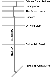
's west end. It runs south from the Ottawa River Parkway
Ottawa River Parkway
The Ottawa River Parkway is a four-lane scenic parkway along the Ottawa River in Ottawa, Ontario, Canada. It runs from Carling Avenue near Connaught Avenue, to Booth Street at the Canadian War Museum. It is maintained by the National Capital Commission. The speed limit is , enforced by the Royal...
through Baseline Road
Baseline Road (Ottawa)
Baseline Road is a road in Ottawa, Ontario, Canada.Baseline runs from Richmond Road east in a straight line until it ends at the Heron Road Bridge over the Rideau River and Rideau Canal when it becomes Heron Road. Before the 2001 City of Ottawa amalgamation, Baseline formed the border of the city...
to Prince of Wales Drive
Prince of Wales Drive (Ottawa)
Prince of Wales Drive is a road serving Ottawa, Ontario, named after the eponymous road in Battersea, London, U.K. The northern section is a low-speed street running along the west bank of the Rideau River, while southern portions of the road were formerly Highway 16 .Prince of Wales Drive is the...
towards the communities of Manotick
Manotick, Ontario
Manotick, Ontario is an exurb in Eastern Ontario on the Rideau River, located on the south edge of Ottawa's urban area. Manotick is located immediately south of the booming suburbs Barrhaven and Riverside South and is about from downtown Ottawa. It has been part of the City of Ottawa since...
and Barrhaven
Barrhaven, Ontario
Barrhaven is a rapidly growing suburban neighbourhood in the southwest of the urban area of the city of Ottawa, Ontario, Canada, about southwest of downtown Ottawa. Prior to amalgamation with Ottawa in 2001, Barrhaven was part of the City of Nepean. Its population as of the Canada 2006 Census was...
. The road runs through the heart of Nepean
Nepean, Ontario
- Recent quantity of snow :- History :Nepean Township, originally known as Township D, was established in 1792 and originally included what is now the central area of Ottawa west of the Rideau River. Jehiel Collins, from Vermont, is believed to have been the first person to settle in Nepean...
in Ottawa
Ottawa
Ottawa is the capital of Canada, the second largest city in the Province of Ontario, and the fourth largest city in the country. The city is located on the south bank of the Ottawa River in the eastern portion of Southern Ontario...
's west end. A satellite Via Rail station is also located at the intersection of Fallowfield Road
Fallowfield Road (Ottawa)
Fallowfield Road , is a major road in southwestern Ottawa. It is a common commuting road for Barrhaven and provides a route to western communities such as Fallowfield village and Munster Hamlet. These communities are served by OC Transpo....
.
Sights on Woodroffe
The northern part of the road, from the Ottawa River to Carling AvenueCarling Avenue
Carling Avenue is a major east-west arterial road in the west end of Ottawa, Ontario, Canada. It runs from March Road in Kanata to Bronson Avenue in the Glebe...
contains a mix of homes and a number of public institutions. This includes Our Lady Of Fatima Catholic Church, Woodroffe Avenue United Church, Woodroffe Avenue Public School, and the Carlingwood branch of the Ottawa Public Library
Ottawa Public Library
The Ottawa Public Library is the library system of Ottawa, Ontario, Canada and is the largest bilingual library in North America...
. Near Carling Avenue, Woodroffe runs along the western edge of the Carlingwood Mall
Carlingwood Mall
Carlingwood Mall is a major mall located in the west end of the city of Ottawa, Ontario. It is operated by 20 Vic Management Incorporated. The mall opened in 1956 and was one of the city's first major shopping centres.-History:Simpsons-Sears department store was opened in 1955...
. South of Carling Avenue the avenue is considerably busier, especially around the intersection with the Queensway
Queensway (Ottawa)
The Queensway is a major controlled-access freeway running through Ottawa, Ontario, Canada, from Kanata in the west to Orleans in the east. It is the primary east-west transportation artery in the Ottawa-Gatineau area....
. This portion of the road is home to St. Paul's Presbyterian Church and D. Roy Kennedy Public School. At Baseline Road the road runs past Algonquin College
Algonquin College
Algonquin College of Applied Arts and Technology is a publicly funded English-language college and member of Polytechnics Canada located in Ottawa, Ontario, Canada. The college serves the National Capital Region and the outlying areas of Eastern Ontario and Western Quebec...
and the College Square shopping plaza (which replaced Shoppers City West) and the closed Confederation High School
Confederation High School (Ottawa)
Confederation High School was an Ottawa area high school from 1967 to 1999. The school was a Carleton Board of Education facility that covered the southern portion of Nepean. This included the community of Barrhaven across the Greenbelt from the school. Barrhaven grew rapidly and eventually the...
. Just to the west is Ben Franklin Place
Ben Franklin Place
Ben Franklin Place is a building complex in the Centrepointe area of Ottawa which houses the Centrepointe Branch of the Ottawa Public Library, the Centrepointe Theatre, and a satellite office for the city of Ottawa. It also includes an outdoor skating rink...
, in the heart of Centrepointe
Centrepointe
Centrepointe is a neighbourhood in Ottawa, Canada and part of the former city of Nepean. The population of Centrepointe is between 4,000 and 4,500 people...
, and the Baseline Station
Baseline Station (OC Transpo)
Baseline Transitway Station is directly across from the main campus of Algonquin College in Ottawa's west end, off of Woodroffe Avenue and Baseline Road. Many Algonquin students and Centrepointe residents use this terminal to get to various points in the city, and of course, to get to the College...
transit complex.
Meadowlands Drive (Ottawa)
Meadowlands Drive is a suburban road in Ottawa, Ontario, Canada. It begins at Prince of Wales Drive as a continuation of Hog's Back Road in the neighborhood of Rideauview. There are two small shopping plazas and a Shell station at its corner with Prince of Wales...
, Woodroffe Avenue passes through mainly suburban residential areas and south of Hunt Club Road it passes through the Greenbelt
Greenbelt (Ottawa)
The Greenbelt is a crescent of land within the present-day boundaries of the city of Ottawa, Ontario, Canada, in which real estate development is strictly controlled. It begins at Shirleys Bay in the west and extends to Green's Creek in the east...
. The most notable site in this area is the large Nepean Sportsplex
Nepean Sportsplex
Nepean Sportsplex is a sports facility in Ottawa, Ontario. It is located on Woodroffe Avenue north of the Ottawa Greenbelt, near the former Confederation High School along OC Transpo route 95. Unfortunately, the sportsplex does not have a website that adequately provides information.- History...
. After passing through a portion of the Greenbelt, Woodroffe Avenue runs through Barrhaven
Barrhaven, Ontario
Barrhaven is a rapidly growing suburban neighbourhood in the southwest of the urban area of the city of Ottawa, Ontario, Canada, about southwest of downtown Ottawa. Prior to amalgamation with Ottawa in 2001, Barrhaven was part of the City of Nepean. Its population as of the Canada 2006 Census was...
, serving as the main street of that bedroom community. South of Barrhaven it again goes through some semi-rural areas, before ending at Prince of Wales Drive
Prince of Wales Drive (Ottawa)
Prince of Wales Drive is a road serving Ottawa, Ontario, named after the eponymous road in Battersea, London, U.K. The northern section is a low-speed street running along the west bank of the Rideau River, while southern portions of the road were formerly Highway 16 .Prince of Wales Drive is the...
just west of the Rideau River
Rideau River
thumb|Rapids on the Rideau River opposite [[Carleton University]].The Rideau River is a Southern Ontario river which flows north from Upper Rideau Lake and empties into the Ottawa River at Rideau Falls in Ottawa, Ontario. Its length is 146 km...
. However, in a couple of years, the housing development will likely reach the end of Woodroffe Avenue, while more development will occur on the western side of it.
Features
Woodroffe Avenue has a few unusual features. First, it changes alignment significantly at Carling Avenue, requiring a couple of turns. Second, the middle section south of Baseline Road includes dedicated bus lanes as it incorporates the Southwest TransitwayOttawa Rapid Transit
In Ottawa, Ontario, Canada, the public transit service operated by OC Transpo has two rapid transit systems: the Transitway, a bus rapid transit network, and the O-Train, a diesel-powered light rail transit service operated on one line.-Major routes:...
. Finally, south of Hunt Club Road
Hunt Club Road (Ottawa)
Hunt Club Road also known as Ottawa Road #32, is a major east-west route in Ottawa, Ontario, Canada. Hunt Club originally ran from Albion Road to Riverside Drive, but was extended east to Hawthorne Road in the late 1980s. The section between Bank Street and Riverside Drive, originally only one lane...
, it was quite narrow and very congested as it was a two-lane rural road heading towards Barrhaven. However, the road was recently widened to four lanes to improve traffic flow between Hunt Club Road and Fallowfield Road. A new section of the Transitway was recently built alongside this road.
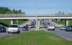
The geometrics and design of Woodroffe Avenue change rapidly from section to section. The northernmost section north of Carling is mostly a two-lane minor arterial road, which becomes a four-lane principal arterial road south of Carling Avenue as far as Baseline Road. These sections have a speed limit of 50 km/h (31.1 mph). From Baseline Road to south of Hunt Club Road, Woodroffe Avenue is a four to six-lane principal arterial (plus bus lanes on each side) with a speed limit of 60 km/h (37.3 mph). From Hunt Club Road to Strandherd Drive
Strandherd Drive (Ottawa)
Strandherd Drive is a major road serving the community of Barrhaven in southwest Ottawa.Up until the mid-1990s, Strandherd Drive was an east-west coursing road extending from Moodie Drive to Woodroffe Avenue...
, Woodroffe Avenue is mostly a four-lane arterial road (the section north of Fallowfield being more rural). The speed limit is 80 km/h (49.7 mph) for the most part, with a short section at 70 km/h (43.5 mph). South of Strandherd Drive, it is still a two-lane road with a speed limit of 80 km/h, however it may decrease in the future with the continuous growth of traffic in the area.
In 2002 a project was announced to widen Woodroffe Avenue from two to four lanes between Fallowfield Park and Ride and Black Rapids Creek. However it was discovered that there is a rare underground rock formation that would double the cost of the project. It was widened as far south as Longfields Avenue. Another section from Longfields to south of Strandherd Road was widened during the summer of 2007 in conjunction with the widening of the latter from Riocan Marketplace to Crestway Avenue.
Further reading
- Woodroffe Avenue Transportation Study Region of Ottawa-Carleton, 2000.
- Woodroffe Avenue Environmental Study Report Ottawa: Dillon Consulting, 2001.
- Secondary Plan for the Woodroffe Community of the City of Nepean. Nepean, Ontario Planning and Development Dept, 1981.