

Ottawa River Parkway
Encyclopedia
Parkway
The term parkway has several distinct principal meanings and numerous synonyms around the world, for either a type of landscaped area or a type of road.Type of landscaped area:...
along the Ottawa River
Ottawa River
The Ottawa River is a river in the Canadian provinces of Ontario and Quebec. For most of its length, it now defines the border between these two provinces.-Geography:...
in Ottawa
Ottawa
Ottawa is the capital of Canada, the second largest city in the Province of Ontario, and the fourth largest city in the country. The city is located on the south bank of the Ottawa River in the eastern portion of Southern Ontario...
, Ontario
Ontario
Ontario is a province of Canada, located in east-central Canada. It is Canada's most populous province and second largest in total area. It is home to the nation's most populous city, Toronto, and the nation's capital, Ottawa....
, Canada
Canada
Canada is a North American country consisting of ten provinces and three territories. Located in the northern part of the continent, it extends from the Atlantic Ocean in the east to the Pacific Ocean in the west, and northward into the Arctic Ocean...
. It runs from Carling Avenue
Carling Avenue
Carling Avenue is a major east-west arterial road in the west end of Ottawa, Ontario, Canada. It runs from March Road in Kanata to Bronson Avenue in the Glebe...
near Connaught Avenue, to Booth Street at the Canadian War Museum. It is maintained by the National Capital Commission
National Capital Commission
The National Capital Commission , is a Canadian Crown corporation that administers the federally owned lands and buildings in Canada's National Capital Region, including Ottawa, Ontario and Gatineau, Quebec.The NCC was created in 1959, replacing the Federal District Commission , which had been...
. The speed limit is 60 km/h (37.3 mph), enforced by the Royal Canadian Mounted Police
Royal Canadian Mounted Police
The Royal Canadian Mounted Police , literally ‘Royal Gendarmerie of Canada’; colloquially known as The Mounties, and internally as ‘The Force’) is the national police force of Canada, and one of the most recognized of its kind in the world. It is unique in the world as a national, federal,...
(RCMP). Bicycles are allowed on the road and on a parallel recreational path
Capital Pathway
The Capital Pathway, also known informally as the The Bike Path, is a recreational pathway interlinking many parks, waterways and sites in Ottawa, Ontario and Gatineau, Quebec...
along the parkway.
Besides being a scenic route, it serves as a commuter artery for west-end residents who work in the downtown area, particularly government employees who work at the Tunney's Pasture
Tunney's Pasture
Tunney's Pasture is an area within the City of Ottawa, Ontario, that is exclusively developed for Canada's federal government buildings. It is bordered by Scott Street to the south, Parkdale Avenue to the east, the Ottawa River Parkway to the north and Northwestern Avenue to the west...
office complex, and other areas. It is also used by the transit systems of Ottawa and Gatineau for express buses.
Route description
The Parkway begins with on and off-ramps from Carling Avenue. The interchange is also the site of the Lincoln Fields Transitway station, with access driveways for OC Transpo buses. The Parkway proceeds north, passing under Richmond Road, then curving eastward along the Ottawa River. The Parkway follows the shore, with both directions separated by a grass median. The area along the river is mostly cleared of trees, allowing a view of the River and far shore line. The area to the south is partially forested, separating the roadway from residential areas to the south.Approximately 1 km from the start of the Parkway, is the Deschenes Rapids scenic lookout area. Driveways connect the two directions of the Parkway to the area, which has a small parking lot and picnic areas. The road meets Woodroffe Avenue a few hundred metres east. Northbound Woodroffe Avenue traffic joins the Parkway's eastbound lanes, while traffic from both directions of the Parkway are allowed onto southbound Woodroffe.
The roadway continues east along the river shore until an signalized intersection with the OC Transpo Transitway. From this point east, the roadway is for the exclusive use of non-commercial vehicles and bicycles. The Parkway follows the river bank to the north, while the Transitway diverges east along an old railway right-of-way.
The next landmark on the Parkway is Kitchissipi Lookout and Beach. The beach is also known as Westboro Beach. The Parkway passes over a pedestrian access walkway from the residential area to the east, with an intersection to the beach parking area. The beach is provided with a pavilion overlooking the River and the beach, which has changing rooms and a restaurant patio.
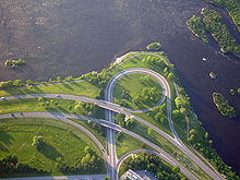
The Parkway curves east and proceeds to a large intersection with Island Park Drive. Island Park connects north to Gatineau across a series of bridges over the Ottawa River. The intersection's traffic lights are controlled to provide turning signals. Just east of the intersection is another park and lookout area, provided with driveways to a parking lot near the river.
The Parkway continues east until a signalized intersection for access to the Tunney's Pasture campus of the federal government. An extra turning lane is provided to access the large parking lot of the campus. Further east, the Parkway passes over Parkdale Avenue, with on and off-ramps between Parkdale and the Parkway. A signalized intersection is provided to the east providing access to the Mechanicsville neighbourhood to the south, and Lemieux Island and its park and filtration station to the north, along an unnamed roadway. Access to and from the Parkway and this intersection is only allowed during off-peak hours.
The Parkway continues east into the LeBreton Flats
Lebreton Flats
LeBreton Flats is a neighbourhood in Ottawa, Canada. It lies to the west of Centretown neighbourhood, and to the north of Centretown West with "Nanny Goat Hill" as the dividing line...
area. The Parkway passes over a former exit to Preston Street. At this point, the Parkway diverges east from the river bank connecting to the extension of Wellington Street into the Flats area. Wellington Street continues east of Booth Street.
Use by buses
It is closed to commercial traffic, so the majority of vehicles are private cars. From Lincoln Fields to Dominion stations, it shares traffic with the Transitway rapid-bus network, as well as STO buses from Gatineau
Gatineau
Gatineau is a city in western Quebec, Canada. It is the fourth largest city in the province. It is located on the northern banks of the Ottawa River, immediately across from Ottawa, Ontario, and together they form Canada's National Capital Region. Ottawa and Gatineau comprise a single Census...
(between Tunney's Pasture
Tunney's Pasture Station (OC Transpo)
Tunney's Pasture Station is a stop on the transitway in Ottawa, Ontario. It is located at the Tunney's Pasture government office complex, on Scott Street at Holland Avenue.The transitway in the area is in a below-grade 'trench' parallel to Scott Street...
and the Champlain Bridge
Champlain Bridge (Ottawa)
The Champlain Bridge crosses the Ottawa River about west of Parliament Hill, joining the communities of Ottawa, Ontario and Gatineau, Quebec. It is the westernmost link between the two cities....
).
Summer Sunday closures
On Sundays during summer months (Victoria Day
Victoria Day
Victoria Day is a federal Canadian public holiday celebrated on the last Monday before May 25, in honour of Queen Victoria's birthday. The date is also, simultaneously, that on which the current reigning Canadian sovereign's official birthday is recognized...
to Labour Day
Labour Day
Labour Day or Labor Day is an annual holiday to celebrate the economic and social achievements of workers. Labour Day has its origins in the labour union movement, specifically the eight-hour day movement, which advocated eight hours for work, eight hours for recreation, and eight hours for...
), the Parkway's westbound lanes are closed to motor vehicles and opened to pedestrian and bicycle traffic from 9 am until 1 pm.
History
The River Parkway was first proposed as part of Greber plans for Ottawa in the 1940s. The parkway was built by purchasing former rail lands along the waterfront, and the purchase of private riverfront houses. The Parkway was designed as a scenic drive, with commercial vehicles prohibited. At the time of its construction, Carling Avenue was part of Ontario Highway 17, and the Parkway provided an alternative, scenic drive to the parliamentary precinct. When the Queensway freewayQueensway (Ottawa)
The Queensway is a major controlled-access freeway running through Ottawa, Ontario, Canada, from Kanata in the west to Orleans in the east. It is the primary east-west transportation artery in the Ottawa-Gatineau area....
was constructed the River Parkway was not extended to the Queensway, and access from the Queensway is marked from the Richmond Road interchange.
In the 1990s, the expansion of the bridge at Island Park was a major issue. The National Capital Commission proposed a fully grade-separated interchange to the River Parkway, with a major expansion in capacity of the bridge over the river. Organized opposition in Ottawa to the plans led to a reduced plan by the NCC. The bridge is three lanes, with the direction of the middle lane switched during different hours of the day. The NCC also built a signalized intersection at Tunney's Pasture at the time.
The construction of the new Canada War Museum on Booth Street was done in conjunction with a re-routing of the section of the River Parkway in the area. The River Parkway's original route parallelled the river bank, bypassing the Lebreton Flats area, passing over Booth Street on an overpass, terminating at the Portage Bridge intersection. The War Museum now occupies the river side location of the old Parkway. The new route connects from just south-west of the Portage Bridge intersection, along a route several hundred metres to the south, passing through Lebreton Flats and intersecting with area streets at signalized intersections. The intersection with Booth Street prohibits turns from Booth Street onto the River Parkway.
Ottawa has proposed to extend its light rail transit network west from downtown. The light rail network may be constructed along the Parkway, a proposal already creating opposition as of 2010.
Exit list
The following is a list of exits along the Ottawa River Parkway. Besides intersections and interchanges, numerous riverside park access roads are listed.| Kilometre post† |
Intersecting roads | Notes |
|---|---|---|
| 0 | Carling Avenue | |
| 1 | SW Transitway Ottawa Rapid Transit In Ottawa, Ontario, Canada, the public transit service operated by OC Transpo has two rapid transit systems: the Transitway, a bus rapid transit network, and the O-Train, a diesel-powered light rail transit service operated on one line.-Major routes:... |
Buses only exit; WB exit, EB entrance |
| 3 | Deschenes Rapids | Park access intersection to access riverside trail and parking. |
| 3 | Woodroffe Avenue Woodroffe Avenue (Ottawa) Woodroffe Avenue is the major north-south arterial road in Ottawa, Ontario, Canada's west end. It runs south from the Ottawa River Parkway through Baseline Road to Prince of Wales Drive towards the communities of Manotick and Barrhaven. The road runs through the heart of Nepean in Ottawa's west end... , Ottawa Road 15 |
At-grade intersection At-grade intersection An at-grade intersection is a junction at which two or more transport axes cross at the same level .-Traffic management:With areas of high or fast traffic, an at-grade intersection normally requires a traffic control device such as a stop sign, traffic light or railway signal to manage conflicting... without traffic lights; no WB access |
| 5 | Transitway | Buses only exit; EB exit, WB entrance |
| 5 | Kitchissipi Lookout | Park access intersection to access riverside trail, parking, and beach. |
| 6 | Island Park Drive | At-grade intersection with traffic lights. |
| 6 | Park Access | Park access intersection to access riverside trail and parking |
| 8 | Tunney's Pasture/Park Access | Access to Goldenrod Street (Tunney's Pasture Tunney's Pasture Tunney's Pasture is an area within the City of Ottawa, Ontario, that is exclusively developed for Canada's federal government buildings. It is bordered by Scott Street to the south, Parkdale Avenue to the east, the Ottawa River Parkway to the north and Northwestern Avenue to the west... ) to the south, riverside trail and parking to the north. |
| 8 | Parkdale Avenue Parkdale Avenue (Ottawa) Parkdale Avenue is an arterial road located west of downtown Ottawa, Ontario, Canada. It runs in a north-south direction between the Ottawa River Parkway and Carling Avenue in the Hintonburg neighbourhood. It is an extremely busy road providing access to Tunney's Pasture, the Parkdale Market, the... , Ottawa Road 71 |
Trumpet Interchange |
| 8 | Slidell Street/River Street (not signed) | NB is access to Lemieux Island Lemieux Island Lemieux Island, , is a small island in the middle of the Ottawa River, between Gatineau, Quebec, and Ottawa, Ontario. It is part of the city of Ottawa. The Prince of Wales Bridge goes over it, and a water filtration plant was built on the island.... , SB is access to Laroche Park, Mechanicsville, Hintonburg |
| 9 | Vimy Place | At-grade intersection |
| 10 | Booth Street | Wellington Street continues east |
†Exits are not numbered.
See also
- Airport ParkwayAirport Parkway (Ottawa)Airport Parkway is an expressway in Ottawa, Ontario, Canada. It runs from the Ottawa Macdonald-Cartier International Airport to an interchange with Heron Road where it turns into Bronson Avenue.-Route description:...
- Aviation ParkwayAviation Parkway (Ottawa)The Aviation Parkway is a parkway in Ottawa, Canada.The parkway begins at Highway 417 and proceeds north, passing beside Ken Steele Park and Ottawa's only French college, La Cité collégiale...
- Rockcliffe ParkwayRockcliffe ParkwayThe Rockcliffe Parkway is a parkway in Ottawa, Canada.The parkway begins at the end of Sussex Drive and follows the Ottawa River, through Rockcliffe Park and past the Canada Aviation Museum. About 200 m after passing Lower Duck Island, it turns towards the south, passing over Regional Road 174. It...