
Ottawa Rapid Transit
Encyclopedia
In Ottawa
, Ontario
, Canada
, the public transit service operated by OC Transpo
has two rapid transit
systems: the Transitway, a bus rapid transit
(BRT) network, and the O-Train
, a diesel
-powered light rail
transit (LRT) service operated on one line.
, having begun service in 1983; many of the Transitway roads are above or below the grade of normal streets in Ottawa, by the use of overpasses, bridges, and trench highways. Thus, they rarely intersect directly with the regular traffic, and make it possible for the buses (and emergency vehicles) to continue at full speed even during rush hour. Buses that travel on the Transitway can cross very long distances (especially outside the downtown area) without stopping for a single traffic light. Most sections of the Transitway have a speed limit of 70 kilometre per hour between stations, and 50 km/h (31.1 mph) in the station areas.
The following routes are high-frequency routes that have a significant portion of their route along the Transitway:
(only bus only roads count as transitway; excluding all routes in Ottawa as transitway routes)
93 - Kanata North to Bayshore and Lebreton.
94 - Millennium to Woodroffe and Tunney's Pasture.
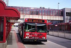
95
- Trim to Barrhaven Centre.
96
- Blair to Queensway (Blair to Hurdman - some weekday trips only, Queensway - eastbound trips only), Pinecrest, Bayshore, Eagleson, Terry Fox, and Stittsville.
97
- Ottawa Airport, via South Keys to Tunney's Pasture, Bayshore and Bells Corners.
98 - Hawthorne via South Keys to Tunney's Pasture.
99 - Lebreton to Greenboro during rush hour. Greenboro and South Riverside, or Riverview at all times.
The following routes are other major crosstown routes that use small stretches of the Transitway:
4
- Billings Bridge to Hurdman
8 - Lebreton to Hurdman and Walkley to Billings Bridge.
85 - Bay to Hurdman
86 - Lincoln Fields to Baseline and Tunney's Pasture to Hurdman.
87 - Heron to Dominion and South Keys to Greenboro.
101 - St. Laurent to Lees, Queensway, Pinecrest (westbound), Bayshore, Eagleson (eastbound), Teron, and Kanata North.
102 - Place d'Orleans to Lees, via Carling to Tunney's Pasture.
106 - Hurdman to Elmvale via Smyth
111 - Lincoln Fields to Baseline and Heron to Hurdman.
114 - Hurdman to St-Laurent and South Keys to Greenboro.
116 - Hurdman to South Keys (Greenboro to Hurdman peak-periods only) and Baseline to Lincoln Fields (peak-periods only except at Baseline).
118 - Terry Fox, Baseline, and Billings Bridge to Place d'Orleans (Hurdman to Place d'Orleans - peak periods only).
176 - Tunney's Pasture to Hurdman (peak-periods only, except at Tunney's Pasture), Fallowfield
182 - Eagleson to Bayshore and Lincoln Fields to Hurdman. Route 182 is an expanded peak-only route.
Most peak-only and express routes also use the Transitway, mostly from downtown out towards the suburbs.
Some Greyhound intercity buses use the Transitway from St-Laurent to Laurier either to/from the city's main bus terminal.
via Bayshore and Baseline stations. This would require rebuilding the ramps connecting the grade-separated section of the Transitway to the Transitway lanes along Highway 417.
To the west, there are new Moodie, Bells Corners, Queensway-Carleton, Hazeldean and Kanata North Transitway stops. To the south, there is a new Nepean Sportsplex stop, and proposed stops for Strandherd and Marketplace. To the east, the Southeastern transitway is extended to Hawthorne, and the Eastern to Blackburn Hamlet and beyond. To the north, there is a planned stop at the Les Terrasses Complex. It also investigates the possibility of transitway buses along Baseline, another downtown location, and from further east on the Queensway from Kirkwood all the way to Eagleson.
New Routes 93, 94, 98, 101, 102, and 108 were included.
, consists of a couplet of single bus-only lanes on Albert and Slater Streets (one-way public streets in opposite east and west directions). Traffic congestion here, where the buses mingle with private vehicles, sometimes causes service delays and is seen by some as the main weakness in the Transitway system. The Transit Committee had planned to reduce the number of buses travelling on Albert and Slater streets by 30% if the extension of the light-rail was implemented. Other measures may be implemented to avoid traffic problems despite the cancellation of the O-Train extension downtown.
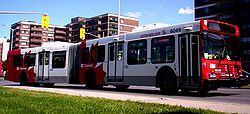 All OC buses are now low floor "accessible" buses, with an aim to improve access to the service by the elderly and handicapped, and to speed up boarding by other passengers; most of these are high-capacity articulated bus
es. Route 96 has used the new Invero low-floor buses since September 2005 and route 101 (formerly known as route 99) since the start of spring 2006. Route 94 and express 61 and 77 are experimenting with three Alexander Dennis Enviro500 double decker buses and OC Transpo plans to buy more to integrate them on other transitway routes.
Some future extensions may include:
Since 2001, Ottawa has operated a light rail
transit system called the O-Train as a pilot for the full rollout of light rail transit technology. The pilot has been deemed a success, exceeding its ridership targets significantly; it carries 10,000 passengers per weekday. The pilot route utilizes former Canadian Pacific Railway
track running south 8 km from the Ottawa River
to Greenboro Station (where the South Keys shopping complex is located), and serves Carleton University
.
The current line was to be replaced, and then extended south-west (but later cancelled by City Council). It would have contained two parallel tracks, and be electrified. Full operation would have begun in 2009-2010 with a total length of 27 km. However, a new transit plan was voted by Council for extensions to Riverside South and with possible extension to downtown (via a tunnel), Blair, Cumberland South and portions of the west end of the city.
The route of the extension was chosen to service areas of future city growth (although some feel that it would have been better to focus on current problem areas). As a part of the extension, the service would have also be routed directly into the downtown core at the north end. The trains would have run on the downtown streets now devoted to the rapid transit corridor, in dedicated lanes. There would have been a reduction in the number of buses passing through the downtown core to accommodate the train lanes.
A formal environmental assessment was underway to examine providing a second line for east-west service. Although the idea was to improve Ottawa's capacity problems for east-west transportation, critics of the process (including light rail supporters) believed the preferred route would have not address these problems successfully.
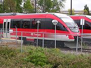
The O-Train utilizes the Bombardier "Talent" Diesel Multiple Unit double-ended trainsets, designed and manufactured by Bombardier in Germany. This is the first application of the Talent in North America.
The Ottawa O-Train
pilot light rail service has five station stops. Bayview (at which it interfaces with the Central Transitway), Carling (interfacing with major bus routes), Carleton (serving Carleton University
), Confederation (intersecting Heron Road), and Greenboro (at which it interfaces with the Southeast Transitway).
Ottawa
Ottawa is the capital of Canada, the second largest city in the Province of Ontario, and the fourth largest city in the country. The city is located on the south bank of the Ottawa River in the eastern portion of Southern Ontario...
, Ontario
Ontario
Ontario is a province of Canada, located in east-central Canada. It is Canada's most populous province and second largest in total area. It is home to the nation's most populous city, Toronto, and the nation's capital, Ottawa....
, Canada
Canada
Canada is a North American country consisting of ten provinces and three territories. Located in the northern part of the continent, it extends from the Atlantic Ocean in the east to the Pacific Ocean in the west, and northward into the Arctic Ocean...
, the public transit service operated by OC Transpo
OC Transpo
OC Transpo is the urban transit service of the City of Ottawa, Ontario, Canada. An integrated hub-and-spoke system of services is available consisting of: regular buses travelling on fixed routes in mixed traffic, typical of most urban transit systems; a bus rapid transit system — a high...
has two rapid transit
Rapid transit
A rapid transit, underground, subway, elevated railway, metro or metropolitan railway system is an electric passenger railway in an urban area with a high capacity and frequency, and grade separation from other traffic. Rapid transit systems are typically located either in underground tunnels or on...
systems: the Transitway, a bus rapid transit
Bus rapid transit
Bus rapid transit is a term applied to a variety of public transportation systems using buses to provide faster, more efficient service than an ordinary bus line. Often this is achieved by making improvements to existing infrastructure, vehicles and scheduling...
(BRT) network, and the O-Train
Ottawa O-Train
The O-Train is a light-rail transit service in Ottawa, Ontario, Canada operated by OC Transpo. The present line runs north-south on a railway line, from Bayview to Greenboro, a distance of approximately...
, a diesel
Diesel engine
A diesel engine is an internal combustion engine that uses the heat of compression to initiate ignition to burn the fuel, which is injected into the combustion chamber...
-powered light rail
Light rail
Light rail or light rail transit is a form of urban rail public transportation that generally has a lower capacity and lower speed than heavy rail and metro systems, but higher capacity and higher speed than traditional street-running tram systems...
transit (LRT) service operated on one line.
Major routes
The Transitway is one of the most extensive and successful implementations of bus rapid transitBus rapid transit
Bus rapid transit is a term applied to a variety of public transportation systems using buses to provide faster, more efficient service than an ordinary bus line. Often this is achieved by making improvements to existing infrastructure, vehicles and scheduling...
, having begun service in 1983; many of the Transitway roads are above or below the grade of normal streets in Ottawa, by the use of overpasses, bridges, and trench highways. Thus, they rarely intersect directly with the regular traffic, and make it possible for the buses (and emergency vehicles) to continue at full speed even during rush hour. Buses that travel on the Transitway can cross very long distances (especially outside the downtown area) without stopping for a single traffic light. Most sections of the Transitway have a speed limit of 70 kilometre per hour between stations, and 50 km/h (31.1 mph) in the station areas.
The following routes are high-frequency routes that have a significant portion of their route along the Transitway:
(only bus only roads count as transitway; excluding all routes in Ottawa as transitway routes)
93 - Kanata North to Bayshore and Lebreton.
94 - Millennium to Woodroffe and Tunney's Pasture.
95
OC Transpo Route 95
OC Transpo Route 95 is the Ottawa transit network's busiest route, running on the Transitway across the city. The termination points are located at Marketplace, at Fallowfield Station and in Orléans, at Place d'Orleans. Weekday trips may be extended to Trim Station, a few minutes east of Place...
- Trim to Barrhaven Centre.
96
OC Transpo Route 96
Route 96 is a major bus-rapid transit route that travels between Terry Fox Station and Hurdman Station via downtown Ottawa and the Transitway. Selected route 96 trips are also extended to serve Stittsville Station and/or Blair Station. It is one of the busiest routes operated by OC Transpo, and...
- Blair to Queensway (Blair to Hurdman - some weekday trips only, Queensway - eastbound trips only), Pinecrest, Bayshore, Eagleson, Terry Fox, and Stittsville.
97
OC Transpo Route 97
OC Transpo Route 97 is a major transitway route that serves important areas across the City of Ottawa including the downtown core and the Ottawa International Airport. It starts at Bayshore Station near the Bayshore Shopping Centre and ends at either South Keys or the Airport. Several trips each...
- Ottawa Airport, via South Keys to Tunney's Pasture, Bayshore and Bells Corners.
98 - Hawthorne via South Keys to Tunney's Pasture.
99 - Lebreton to Greenboro during rush hour. Greenboro and South Riverside, or Riverview at all times.
The following routes are other major crosstown routes that use small stretches of the Transitway:
4
OC Transpo Route 4
Route 4, in Ottawa, Canada, is a crosstown bus route, operated by OC Transpo, that runs between Hurdman Station and the Rideau Centre in downtown Ottawa. All trips also serve Carleton University...
- Billings Bridge to Hurdman
8 - Lebreton to Hurdman and Walkley to Billings Bridge.
85 - Bay to Hurdman
86 - Lincoln Fields to Baseline and Tunney's Pasture to Hurdman.
87 - Heron to Dominion and South Keys to Greenboro.
101 - St. Laurent to Lees, Queensway, Pinecrest (westbound), Bayshore, Eagleson (eastbound), Teron, and Kanata North.
102 - Place d'Orleans to Lees, via Carling to Tunney's Pasture.
106 - Hurdman to Elmvale via Smyth
111 - Lincoln Fields to Baseline and Heron to Hurdman.
114 - Hurdman to St-Laurent and South Keys to Greenboro.
116 - Hurdman to South Keys (Greenboro to Hurdman peak-periods only) and Baseline to Lincoln Fields (peak-periods only except at Baseline).
118 - Terry Fox, Baseline, and Billings Bridge to Place d'Orleans (Hurdman to Place d'Orleans - peak periods only).
176 - Tunney's Pasture to Hurdman (peak-periods only, except at Tunney's Pasture), Fallowfield
182 - Eagleson to Bayshore and Lincoln Fields to Hurdman. Route 182 is an expanded peak-only route.
Most peak-only and express routes also use the Transitway, mostly from downtown out towards the suburbs.
Some Greyhound intercity buses use the Transitway from St-Laurent to Laurier either to/from the city's main bus terminal.
Future or proposed new routes
A coalition group had launched a website (see external links section below) about a proposed new route from Barrhaven to KanataKanata
Kanata is an aboriginal word meaning "village" or "settlement."- Name of Canada :Until the mid-20th century, the Mohawk word "kanata" was thought to have been the origin of Canada's name...
via Bayshore and Baseline stations. This would require rebuilding the ramps connecting the grade-separated section of the Transitway to the Transitway lanes along Highway 417.
2009 Transit Service Plan
In June 2006, the City of Ottawa released a 2009 service plan for the O-Train route, the Transitway and new bus routes. (This plan was cancelled shortly after the 2006 municipal election.)To the west, there are new Moodie, Bells Corners, Queensway-Carleton, Hazeldean and Kanata North Transitway stops. To the south, there is a new Nepean Sportsplex stop, and proposed stops for Strandherd and Marketplace. To the east, the Southeastern transitway is extended to Hawthorne, and the Eastern to Blackburn Hamlet and beyond. To the north, there is a planned stop at the Les Terrasses Complex. It also investigates the possibility of transitway buses along Baseline, another downtown location, and from further east on the Queensway from Kirkwood all the way to Eagleson.
New Routes 93, 94, 98, 101, 102, and 108 were included.
Central Transitway traffic issue
The downtown section of the Transitway, the Central TransitwayCentral Transitway (OC Transpo)
The Central Transitway is the downtown section of Ottawa, Ontario, Canada's Transitway. This section of the Transitway uses dedicated lanes on existing streets, namely Albert Street for westbound routes and Slater Street for eastbound routes...
, consists of a couplet of single bus-only lanes on Albert and Slater Streets (one-way public streets in opposite east and west directions). Traffic congestion here, where the buses mingle with private vehicles, sometimes causes service delays and is seen by some as the main weakness in the Transitway system. The Transit Committee had planned to reduce the number of buses travelling on Albert and Slater streets by 30% if the extension of the light-rail was implemented. Other measures may be implemented to avoid traffic problems despite the cancellation of the O-Train extension downtown.
Type of buses
Articulated bus
An articulated bus is an articulated vehicle used in public transportation. It is usually a single-deck design, and comprises two rigid sections linked by a pivoting joint...
es. Route 96 has used the new Invero low-floor buses since September 2005 and route 101 (formerly known as route 99) since the start of spring 2006. Route 94 and express 61 and 77 are experimenting with three Alexander Dennis Enviro500 double decker buses and OC Transpo plans to buy more to integrate them on other transitway routes.
Extension projects
There have been plans to expand the transitway to reach other parts of Ottawa; it now only runs along the north edge of the city for most of the central area, leaving Transitway bus routes (94, 95, 96, 97) to mix with other traffic on local streets on the end parts of their runs.Some future extensions may include:
- From Bayshore StationBayshore Station (OC Transpo)Bayshore Transitway Station is a transit station on Ottawa, Ontario, Canada's transitway served by OC Transpo buses. It is located in the western transitway section at the Bayshore Shopping Centre...
to Moodie Drive to provide service to the new National Defence Headquarters site. - From Eagleson StationEagleson Station (OC Transpo)Eagleson "Eva James" Transitway Station is a station on Ottawa, Ontario, Canada's transitway served by OC Transpo buses. It is located in the western transitway section at Eagleson Road and Highway 417...
to Moodie Drive. - From Eagleson StationEagleson Station (OC Transpo)Eagleson "Eva James" Transitway Station is a station on Ottawa, Ontario, Canada's transitway served by OC Transpo buses. It is located in the western transitway section at Eagleson Road and Highway 417...
to Hazeldean RoadHazeldean Road (Ottawa)Hazeldean Road is a major road in Ottawa's west end. This road runs between the junction of Highway 7 west of Stittsville and Eagleson Road in Kanata, where it becomes Robertson Road east of the intersection and proceeds towards Bells Corners in the former city of Nepean, Ontario as a four-lane...
west of Terry Fox Drive - From Place d'Orléans Station to Trim StationTrim Station (OC Transpo)Trim Station is a Ottawa, Canada, transitway station in the east end of the city located near Trim Road and Regional Road 174 . A Natrel factory is located near this station...
- A temporary roadway linking the Innes/Blair area to South OrleansOrléans, OntarioOrleans , also written Orléans, is a suburban area within the city of Ottawa, Ontario, Canada. It is located in the eastern part of the city along the Ottawa River, about from downtown Ottawa. The Canada 2006 Census gave Orleans a population of 95,491. It became a ward of the City of Ottawa in 2001...
- then potentially reverting to a future East-West light-rail route.
Light rail transit: the O-Train
Since 2001, Ottawa has operated a light rail
Light rail
Light rail or light rail transit is a form of urban rail public transportation that generally has a lower capacity and lower speed than heavy rail and metro systems, but higher capacity and higher speed than traditional street-running tram systems...
transit system called the O-Train as a pilot for the full rollout of light rail transit technology. The pilot has been deemed a success, exceeding its ridership targets significantly; it carries 10,000 passengers per weekday. The pilot route utilizes former Canadian Pacific Railway
Canadian Pacific Railway
The Canadian Pacific Railway , formerly also known as CP Rail between 1968 and 1996, is a historic Canadian Class I railway founded in 1881 and now operated by Canadian Pacific Railway Limited, which began operations as legal owner in a corporate restructuring in 2001...
track running south 8 km from the Ottawa River
Ottawa River
The Ottawa River is a river in the Canadian provinces of Ontario and Quebec. For most of its length, it now defines the border between these two provinces.-Geography:...
to Greenboro Station (where the South Keys shopping complex is located), and serves Carleton University
Carleton University
Carleton University is a comprehensive university located in the capital of Canada, Ottawa, Ontario. The enabling legislation is The Carleton University Act, 1952, S.O. 1952. Founded as a small college in 1942, Carleton now offers over 65 programs in a diverse range of disciplines. Carleton has...
.
The current line was to be replaced, and then extended south-west (but later cancelled by City Council). It would have contained two parallel tracks, and be electrified. Full operation would have begun in 2009-2010 with a total length of 27 km. However, a new transit plan was voted by Council for extensions to Riverside South and with possible extension to downtown (via a tunnel), Blair, Cumberland South and portions of the west end of the city.
The route of the extension was chosen to service areas of future city growth (although some feel that it would have been better to focus on current problem areas). As a part of the extension, the service would have also be routed directly into the downtown core at the north end. The trains would have run on the downtown streets now devoted to the rapid transit corridor, in dedicated lanes. There would have been a reduction in the number of buses passing through the downtown core to accommodate the train lanes.
A formal environmental assessment was underway to examine providing a second line for east-west service. Although the idea was to improve Ottawa's capacity problems for east-west transportation, critics of the process (including light rail supporters) believed the preferred route would have not address these problems successfully.
The O-Train utilizes the Bombardier "Talent" Diesel Multiple Unit double-ended trainsets, designed and manufactured by Bombardier in Germany. This is the first application of the Talent in North America.
Rapid transit stations
Southwest (94/ 95)
- Barrhaven Centre (also known as Marketplace Station) - This is the terminus of route 95 on some routes traveling westbound. Located in the shopping core of Barrhaven, the majority of the routes in Barrhaven now pass this busy and ever expanding shopping arena. This was originally intended to be the future end of the City's O-Train route.
- StrandherdStrandherd Station (OC Transpo)Strandherd Station is a transit station in Ottawa, Ontario. It opened on January 2, 2007 and contains a park and ride facility with over 300 parking spaces available. It is located northeast of the intersection of Strandherd Drive and the access to the Riocan Marketplace shopping area in which...
- One of the newest additions to the Transitway network in Ottawa, this station has the 95 running every 12–15 minutes every rush hour, and every 30 minutes until 23:00. Supplemental services are provided by routes 71, 73, 181, 186, and Connexion route 406. Early-morning route 873 also served here until it was replaced in September 2010. This site has roughly 300 parking spaces, later to be expanded as the need is demanded. - LongfieldsLongfields Station (OC Transpo)Longfields Station is a Southwest Transitway station in the Longfields neighbourhood of Ottawa, Ontario, Canada. The station is located on a route that runs along the south side of the CNR railway line southwest from Fallowfield Station towards Strandherd Station.Located close to the station are...
- The newest segment of the transitway opened in June 2011; this station acts as a local station, between two major populated areas. Route 71, 73, 95, 186 serve this station. - Woodroffe Station/Chapman Mills Station - Located at the corner of Woodroffe and between Strandherd and Chapman Mills, this is the Westerly Terminus of Route 94. Eventually this site will be the site of the new Chapman Mills Park and Ride. Served by Route 94, 176.
- FallowfieldFallowfield Station (OC Transpo)Fallowfield is a bus station on Ottawa's transitway system. Operated by OC Transpo, it is located at Woodroffe Avenue and Fallowfield Road in the community of Barrhaven, next to the Fallowfield railway station....
- Located at the corner of Woodroffe Avenue and Fallowfield Road in Barrhaven, beside Via RailVIA RailVia Rail Canada is an independent crown corporation offering intercity passenger rail services in Canada. It is headquartered near Montreal Central Station at 3 Place Ville-Marie in Montreal, Quebec....
's Fallowfield Station. This station acts as the western terminus of Route 95 for trips not continuing to Strandherd, Longfields, Martketplace, and Barrhaven Centre.
- Fallowfield to near Nepean SportsplexNepean SportsplexNepean Sportsplex is a sports facility in Ottawa, Ontario. It is located on Woodroffe Avenue north of the Ottawa Greenbelt, near the former Confederation High School along OC Transpo route 95. Unfortunately, the sportsplex does not have a website that adequately provides information.- History...
is along a $10 million isolated bus-only road (opened on December 13, 2005), although this section has no stations and features a railway level crossingLevel crossingA level crossing occurs where a railway line is intersected by a road or path onone level, without recourse to a bridge or tunnel. It is a type of at-grade intersection. The term also applies when a light rail line with separate right-of-way or reserved track crosses a road in the same fashion...
, the first on the Transitway. From Nepean Sportsplex to Baseline Station, buses run along Woodroffe Avenue in dedicated lanes, making several stops at regular bus stops.- BaselineBaseline Station (OC Transpo)Baseline Transitway Station is directly across from the main campus of Algonquin College in Ottawa's west end, off of Woodroffe Avenue and Baseline Road. Many Algonquin students and Centrepointe residents use this terminal to get to various points in the city, and of course, to get to the College...
- Located on Woodroffe Avenue across from Algonquin CollegeAlgonquin CollegeAlgonquin College of Applied Arts and Technology is a publicly funded English-language college and member of Polytechnics Canada located in Ottawa, Ontario, Canada. The college serves the National Capital Region and the outlying areas of Eastern Ontario and Western Quebec...
of Applied Arts and Technology. Western terminal of about half of all midday trips of Route 95; buses terminating here are marked "95X Baseline".
- Baseline
- Beyond Baseline, the Transitway is fully isolated to Lincoln Fields.
- IrisIris Station (OC Transpo)Iris Transitway Station is located at a grade-level crossing at the southwest transitway and Iris Street...
- Located on Iris Street in Kenson Park. - QueenswayQueensway Station (OC Transpo)Queensway Transitway Station is located around and under the Queensway along the southwest transitway leg. The upper platforms provide access to the crosstown Route 101 while the lower platforms are for transitway routes such as the 95 and eastbound trips of Route 96.Despite its seemingly isolated...
- Located at the QueenswayQueensway (Ottawa)The Queensway is a major controlled-access freeway running through Ottawa, Ontario, Canada, from Kanata in the west to Orleans in the east. It is the primary east-west transportation artery in the Ottawa-Gatineau area....
and Woodroffe in the WhitehavenWhitehaven (Ottawa)Whitehaven is a neighbourhood about 10 kilometres west of downtown Ottawa. It is bounded by Carling Avenue to the north, Woodroffe Avenue to the east, the OC Transpo Transitway to the west and highway 417 to the south....
neighbourhood. Also serves eastbound Route 96 travelling to HurdmanHurdman Station (OC Transpo)Hurdman Transitway Station is a station on Ottawa's transitway. Hurdman is one of the busier stations, perhaps the busiest, as it is the main hub of the transitway network east of downtown. Hurdman is where the main transitway route from downtown to west branches off in two directions: one to the...
and BlairBlair Station (OC Transpo)Blair Station is a station on Ottawa's transitway located at Blair Road and Regional Road 174. It is the eastern terminal for most weekday peak morning trips of Route 101 , several weekday trips of route 96 and crosstown route 12...
.
- Iris
West (93, 96, 97)
- StittsvilleStittsville Station (OC Transpo)Stittsville Transitway Station is a bus-stop on Ottawa, Ontario's transitway served by OC Transpo buses. It is located in the western transitway section in Stittsville, Ontario, in the centre of the community.It is the Western terminus of some Route 96 trips...
- Western terminus of some route 96 trips. Park and Ride facility located in StittsvilleStittsville, OntarioStittsville is a suburban community in the western part of Ottawa, Ontario, Canada. A part of the National Capital Region, Stittsville is located immediately to the south-west of Kanata, and about from downtown Ottawa.-History:...
. - Terry FoxTerry Fox Station (OC Transpo)Terry Fox Transitway Station is a bus-stop on Ottawa, Ontario, Canada's transitway served by OC Transpo buses and named after cancer research activist Terry Fox...
- Located adjacent the KanataKanata, OntarioSituated in the Ottawa Valley, Kanata is located about west-southwest of Downtown Ottawa along Highway 417 at a latitude of 45°18' North and a longitude of 75°55' West, with an area of . Its northern end is just to the west of the Ottawa River....
Centrum shopping centre at Kanata Avenue and Earl Grey Drive (near 417 and Terry Fox Drive). Most eastbound 96 trips begin here. Entered service in September 2004 with construction still having been underway at that time; it officially opened on February 22, 2005. Previously, a small terminal at Kanata Town Centre, on Katimavik Road, was used.
- To this point the route is on non-dedicated street lanes along collector and arterial roads, much like a standard bus route. Regular stops are made between Stittsville and Eagleson. However, in the long range, there are possible plans to built a Transitway segment between the two stations. In addition, Teron StationTeron Station (OC Transpo)Teron Station is a OC Transpo Transitway Station in Ottawa, Ontario. The stationis located in the suburb of Kanata near the intersection of Campeau Drive and the Highway 417 western off-ramp at March Road. It is also located about an overpass north of Eagleson Station and Park and Ride...
, located at the corner of Campeau Drive and March Road, is a station opened September 2007 served by Rapid Transit Route 101. http://ottawa.ca/calendar/ottawa/citycouncil/tc/2007/06-06/ACS2007-PTE-TRA-0008.htm- EaglesonEagleson Station (OC Transpo)Eagleson "Eva James" Transitway Station is a station on Ottawa, Ontario, Canada's transitway served by OC Transpo buses. It is located in the western transitway section at Eagleson Road and Highway 417...
- Park and Ride located at Eagleson Rd. and Highway 417. All morning Kanata express routes (and some afternoon ones), and routes 96 and 101, serve this station.
- Eagleson
- The Transitway proper starts past Eagleson, with a dedicated lane on the 417. One stop is made (on request only via a special signal) at the Moodie Drive interchange.
- Teron Station - Located north of the 417, the Gateway for the Transitway to the North in Kanata.
- BayshoreBayshore Station (OC Transpo)Bayshore Transitway Station is a transit station on Ottawa, Ontario, Canada's transitway served by OC Transpo buses. It is located in the western transitway section at the Bayshore Shopping Centre...
- Located at the Bayshore Shopping CentreBayshore Shopping CentreBayshore Shopping Centre is a major shopping mall located in Ottawa, Ontario, Canada, more specifically in the former city of Nepean, Ontario. The mall is one of the busiest in the National Capital Region as it attracts about 7 million visitors per year from across the city and the surrounding...
. Main Western terminus of Route 97 and Route 101.
- The Transitway leaves the 417 at Bayshore and follows the northern edge of the 417 to the new Pinecrest Station before returning to dedicated lanes on Highway 417. There is no date on when the section between Pinecrest and the Southwest Transitway will be built.http://www.ottawasun.com/News/OttawaAndRegion/2006/06/10/1623919-sun.html
Central (all routes)
- At Lincoln Fields, the West and Southwest branches merge.
- Lincoln FieldsLincoln Fields Station (OC Transpo)Lincoln Fields Station is a station on Ottawa's transitway located at Carling Avenue and the Ottawa River Parkway. It is adjacent but not connected to nearby Lincoln Heights Galleria Shopping Centre. It is the main western hub of the transitway system and has a ticket sales and information office...
- Located at Carling Avenue and the Ottawa River ParkwayOttawa River ParkwayThe Ottawa River Parkway is a four-lane scenic parkway along the Ottawa River in Ottawa, Ontario, Canada. It runs from Carling Avenue near Connaught Avenue, to Booth Street at the Canadian War Museum. It is maintained by the National Capital Commission. The speed limit is , enforced by the Royal...
.
- Lincoln Fields
- From Lincoln Fields to Dominion, the Transitway travels the Ottawa River Parkway in a shared traffic lane.
- DominionDominion Station (OC Transpo)Dominion Station is a stop on the transitway in Ottawa, Ontario. It is located north of the western edge of Westboro village, where the below-grade transitway segment joins the Ottawa River Parkway...
- Located off Dominion Avenue on the Ottawa River Parkway.
- Dominion
- From Dominion to just past Tunney's Pasture Station, the Transitway runs in an isolated, below-grade road built along the alignment of a former railway line.
- WestboroWestboro Station (OC Transpo)Westboro Station is a stop on the transitway in Ottawa, Ontario. It is located in the Westboro neighbourhood, on Scott Street between Athlone and Tweedsmuir avenues.The transitway in the area is in a below-grade 'trench' parallelling Scott Street...
- Located on Scott Street in Westboro. - Tunney's PastureTunney's Pasture Station (OC Transpo)Tunney's Pasture Station is a stop on the transitway in Ottawa, Ontario. It is located at the Tunney's Pasture government office complex, on Scott Street at Holland Avenue.The transitway in the area is in a below-grade 'trench' parallel to Scott Street...
- Located at Scott Street and Holland Avenue at the Tunney's PastureTunney's PastureTunney's Pasture is an area within the City of Ottawa, Ontario, that is exclusively developed for Canada's federal government buildings. It is bordered by Scott Street to the south, Parkdale Avenue to the east, the Ottawa River Parkway to the north and Northwestern Avenue to the west...
government office complex.
- Westboro
- From just past Tunney's Pasture Station to Booth Street, the Transitway emerges from below-grade and runs in an isolated, at-grade road built on a former railway yard. Main western terminus for routes 94, 98 and 102. It also serves as an occasional terminus for route 97 as well as some rush hour trips of route 95.
- BayviewBayview Station (OC Transpo)Bayview Station is a transitway and O-Train station in Ottawa, Ontario. The bus stop is at the eastern end of Scott Street when it becomes Wellington Street. The O-Train station, the northern terminus of the current line, is located on a stub-end track branching off from the railway line,...
(O-Train) - Located at the eastern end of Scott Street when it becomes Wellington Street. Northern terminus of the O-TrainOttawa O-TrainThe O-Train is a light-rail transit service in Ottawa, Ontario, Canada operated by OC Transpo. The present line runs north-south on a railway line, from Bayview to Greenboro, a distance of approximately...
. - LebretonLebreton Station (OC Transpo)Lebreton Station is a stop on the transitway in Ottawa. It is located in the Lebreton Flats area, near the intersection of Wellington Street and Booth Street...
- Located on Booth Street in Lebreton FlatsLebreton FlatsLeBreton Flats is a neighbourhood in Ottawa, Canada. It lies to the west of Centretown neighbourhood, and to the north of Centretown West with "Nanny Goat Hill" as the dividing line...
. Rush hour terminus for route 99 and route 93.
- Bayview
- Just past Lebreton, the isolated transitway ends and eastbound buses take Slater Street, while westbound buses are on Albert Street; there are dedicated lanes on both streets, but traffic is generally slow in the dense downtown core. This arrangement continues to just past Metcalfe.
- BayBay Station (OC Transpo)Bay Transitway Station is a bus stop on Ottawa, Ontario, Canada's transitway served by OC Transpo buses. It is located in the central transitway section at Bay Street, with two substations on Albert Street and Slater Street....
- Located on Albert and Slater Streets at Bay Street. - KentKent Station (OC Transpo)Kent Transitway Station is a bus-stop on Ottawa, Ontario, Canada's transitway served by OC Transpo buses. It is located in the central transitway section, appearing on both Albert Street and Slater Street....
- Located on Albert and Slater Streets at Kent StreetKent Street (Ottawa)Kent Street is a major street in downtown Ottawa, Canada. One block west of Bank Street, Kent is one way running north. It begins at the Queensway at the south and ends at Wellington Street. The street has fewer storefronts than Bank Street. South of downtown it is mainly small and medium sized...
. - BankBank Station (OC Transpo)Bank Transitway Station or Bank Street Station is a bus-stop on Ottawa, Ontario, Canada's transitway served by OC Transpo buses. It is located on the central transitway, which is part of the 95 line, 96 line and 97 line. Bank is named for Bank Street which is located perpendicular to the...
- Located on Albert and Slater Streets at Bank StreetBank Street (Ottawa)Bank Street is the major north-south road in Ottawa, Ontario, Canada. It runs south from Wellington Street in downtown Ottawa, south through the neighbourhoods of Centretown, The Glebe, Old Ottawa South, Alta Vista, Hunt Club, and then through the villages of Blossom Park, Leitrim, South...
. - MetcalfeMetcalfe Station (OC Transpo)Metcalfe Station is a bus station on OC Transpo's Central Transitway. There are two parts of the station, as the Transitway runs on two parallel streets. The north station serves westbound traffic, and is found on Albert Street, and the south station serves eastbound traffic, and is found on...
- Located on Albert and Slater Streets at Metcalfe Street.
- Bay
- Over the Mackenzie King Bridge, the Transitway continues in dedicated lanes. The isolated Transitway resumes at Waller Street.
- Mackenzie KingMackenzie King Station (OC Transpo)Mackenzie King Station is a major station on the OC Transpo transitway. It is served by all three of OC Transpo's principal routes along with all express routes and several crosstown routes...
- Located on the Mackenzie King BridgeMackenzie King BridgeThe Mackenzie King Bridge is a bridge in Ottawa, Ontario, Canada. Just a few blocks away from Parliament Hill, south of the Plaza Bridge, it runs in a generally east-west direction, with the east end at the Rideau Centre and Department of National Defence Headquarters. The west end runs between...
at the Rideau CentreRideau CentreRideau Centre is a three-level shopping centre on Rideau Street in Downtown Ottawa, Ontario, Canada. It borders on Rideau Street , the Rideau Canal, the Mackenzie King Bridge, and Nicholas Street....
and the Department of National Defence headquartersDepartment of National Defence Headquarters (Canada)The Major-General George R. Pearkes Building is the principal location of Canada's National Defence Headquarters and is located in Ottawa, Ontario....
. After 1:00 a.m., the three Transitway routes (95, 96, and 97) travel via Rideau Street instead of the MacKenzie King Bridge. - LaurierLaurier Station (OC Transpo)Laurier Transitway Station is at a three-street intersection where the Mackenzie King Bridge and Waller Street meet the OC Transpo Transitway, very close to Nicholas Street. Stewart Street begins at Waller Street a few metres away...
- Located at Laurier Avenue and Waller Street at the University of OttawaUniversity of OttawaThe University of Ottawa is a bilingual, research-intensive, non-denominational, international university in Ottawa, Ontario. It is one of the oldest universities in Canada. It was originally established as the College of Bytown in 1848 by the Missionary Oblates of Mary Immaculate...
. - CampusCampus Station (OC Transpo)Campus Transitway Station is a station on Ottawa's transitway. The stop number is 3021, located just east of the Rideau Canal at the western terminus of Somerset Street East, the station services the University of Ottawa's southern section and the Sandy Hill neighbourhood...
- Located at the University of OttawaUniversity of OttawaThe University of Ottawa is a bilingual, research-intensive, non-denominational, international university in Ottawa, Ontario. It is one of the oldest universities in Canada. It was originally established as the College of Bytown in 1848 by the Missionary Oblates of Mary Immaculate...
. - LeesLees Station (OC Transpo)Lees Transitway Station is a station on Ottawa's transitway. It is located south of the Queensway just to the west of the Rideau River. It serves the Lees Avenue region and the Sandy Hill Heights community....
- Located on Lees Avenue. - HurdmanHurdman Station (OC Transpo)Hurdman Transitway Station is a station on Ottawa's transitway. Hurdman is one of the busier stations, perhaps the busiest, as it is the main hub of the transitway network east of downtown. Hurdman is where the main transitway route from downtown to west branches off in two directions: one to the...
- Located near Riverside DriveRiverside DriveA number of cities around the world have a Riverside Drive.In the United States:*Riverside Drive *Riverside Drive *Riverside Drive *Riverside Drive...
and Industrial Avenue. Eastern terminus of most route 96 trips, as well as western terminus for route 106 that travels to Elmvale.
- Mackenzie King
- Just past Hurdman, the Transitway branches into two: the East Transitway and Southeast Transitway.
East (94, 95, 96)
- TrainTrain Station (OC Transpo)Train Station is a station on Ottawa's transitway. Despite its name, it is a bus stop on the transitway system, not a train station. However, it is connected to Ottawa's main railway station....
- Located at Via RailVIA RailVia Rail Canada is an independent crown corporation offering intercity passenger rail services in Canada. It is headquartered near Montreal Central Station at 3 Place Ville-Marie in Montreal, Quebec....
's Ottawa StationOttawa Train StationOttawa Station in Ottawa, Ontario, Canada, located at 200 Tremblay Road, is served by Via Rail inter-city trains connecting it to Toronto and Montreal. OC Transpo’s Train rapid transit station carries railway passengers into the city centre or into the eastern suburbs.The station was designed by...
on Tremblay Road.
- Past Train, the dedicated Transitway parallels the Queensway to beyond Blair.
- St. LaurentSt. Laurent Station (OC Transpo)St. Laurent Station is a station on Ottawa's transitway located at St. Laurent Boulevard and the Queensway. This station is the most integrated to its surroundings with direct indoor pedestrian access to the St. Laurent Shopping Centre...
- Located at the St. Laurent Shopping CentreSt. Laurent Shopping CentreSt. Laurent Shopping Centre is a major shopping centre located in Ottawa, Ontario, Canada owned and operated by Morguard REIT. The shopping mall is located just north of Highway 417 at the corner of St. Laurent Boulevard and Coventry Road. It opened its doors in 1967.St...
on St. Laurent Boulevard. Only operational underground station. - CyrvilleCyrville Station (OC Transpo)Cyrville Station is a station on Ottawa's transitway located at Cyrville Road and the Queensway...
- Located at Cyrville Road and the Queensway. - BlairBlair Station (OC Transpo)Blair Station is a station on Ottawa's transitway located at Blair Road and Regional Road 174. It is the eastern terminal for most weekday peak morning trips of Route 101 , several weekday trips of route 96 and crosstown route 12...
- Located at the Gloucester Centre on Blair Road.
- St. Laurent
- The Transitway joins Regional Road 174 a short stretch past Blair, running in a dedicated lane. Some weekday route 96 trips start/end here. Route 95 buses exit at Montreal Road and at Jeanne d'Arc Boulevard and stop on the ramps at ordinary bus stops; these will be upgraded to full Transitway stations by 2009, tentatively named Montreal/St. Joseph and Jeanne d'Arc Stations. On the 2006-2007 system map, OC Transpo had included Jeanne d'Arc as a transit station.
- Jeanne d'ArcJeanne d'Arc Station (OC Transpo)Jeanne d'Arc Station is a bus stop on Ottawa's Rapid Transit Network. It is located at the interchange of Regional Road 174 and Jeanne d'Arc Boulevard in Orleans in the east end of the city of Ottawa....
- Provides supplemental parking spaces to the expanding suburb of Orléans (roughly 30 parking spaces). - Place d'Orléans - Located at the Place d'OrleansPlace d'OrleansPlace d'Orléans is a large shopping mall in the eastern end of Ottawa, Ontario, Canada, in the community of Orléans. The property is about . It currently holds three large department stores and about 175 small shops, including a food court...
shopping complex in OrleansOrléans, OntarioOrleans , also written Orléans, is a suburban area within the city of Ottawa, Ontario, Canada. It is located in the eastern part of the city along the Ottawa River, about from downtown Ottawa. The Canada 2006 Census gave Orleans a population of 95,491. It became a ward of the City of Ottawa in 2001...
and is the main eastern terminus of routes 95 and 101 and peak-only route 102.
- Jeanne d'Arc
- There is no dedicated bus lane from Place d'Orleans to Trim, buses run in mixed traffic. However, in the long range there could be a separate route built.
- TrimTrim Station (OC Transpo)Trim Station is a Ottawa, Canada, transitway station in the east end of the city located near Trim Road and Regional Road 174 . A Natrel factory is located near this station...
- Located at Trim Road. This park-and-ride station is used by route 95 on weekdays. - MillenniumMillennium Station (OC Transpo)Millennium Station is a current rapid-transit bus-stop and a future OC Transpo Transitway Station located in the Orleans, Ontario area of Ottawa, Canada, just south of the intersection of Innes Road and Trim Road. Starting in September 2007, it is the eastern terminus of most Route 94 trips as well...
- Intersection of Trim and Innes roads. This is the eastern terminus of route 94.
- Trim
Southeast (97, 98, 99)
- Lycée ClaudelLycée Claudel Station (OC Transpo)The Lycée Claudel Transitway Station is a station on Ottawa, Canada's transitway. It is located on the 97 rapid transit line, and is one stop south of the main hub of Hurdman...
(formerly Abbey) - Located on old Riverside Drive across from the Lycée Claudel school. - SmythSmyth Station (OC Transpo)Smyth Transitway Station is a bus-stop on Ottawa's transitway served by OC Transpo buses. It is located in the south-eastern transitway section at Riverside Drive and Smyth Road....
- Located at Riverside DriveRiverside DriveA number of cities around the world have a Riverside Drive.In the United States:*Riverside Drive *Riverside Drive *Riverside Drive *Riverside Drive...
and Smyth Road. - RiversideRiverside Station (OC Transpo)The Riverside Transitway Station is the OC Transpo transitway stop that is connected to the Riverside Campus of The Ottawa Hospital near the intersection of Smyth Road and Riverside Drive...
- Located at the Riverside CampusThe Ottawa HospitalThe Ottawa Hospital or L'Hôpital d'Ottawa is a major, non-profit, public, university teaching hospital in Ottawa made up of the former Grace Hospital, Riverside Hospital, Ottawa General Hospital and Ottawa Civic Hospital. It is a 1,195-bed academic health sciences centre...
of the Ottawa Hospital on Riverside Drive. - Pleasant ParkPleasant Park Station (OC Transpo)Pleasant Park Transitway Station is a bus stop on Ottawa's transitway served by OC Transpo buses. It is located in the southeastern transitway section at Pleasant Park Road near Riverside Drive...
- Located at Pleasant Park Road and Riverside Drive. - Billings BridgeBillings Bridge Station (OC Transpo)The Billings Bridge Transitway Station is a station on the OC Transpo transitway, adjacent to the Billings Bridge Plaza. It is named for, not only the plaza, but after Billings Bridge itself which is both a nearby bridge and neighbourhood...
- Located at the Billings Bridge PlazaBillings Bridge PlazaThe Billings Bridge Plaza is a shopping centre located in Ottawa, Canada. Originally built in 1954, it was the first shopping centre built in the city. It did not become enclosed until 1972. It is located immediately south of the Rideau River on the corner of Bank Street and Riverside Drive,...
on Bank Street. - HeronHeron Station (OC Transpo)Heron Transitway Station is a bus-stop on Ottawa's transitway served by OC Transpo buses. It is located in the south-eastern transitway section at Heron Park on Heron Road....
- Located at Heron Park on Heron RoadHeron Road (Ottawa)Heron Road is a major road in Ottawa, Ontario, Canada. It runs from Walkley Road at an angle to the Rideau River, where it turns into Baseline Road. Heron is home to the Public Works and Government Services Canada headquarters, as well as the Canada Post headquarters and the Edward Drake Building...
. - WalkleyWalkley Station (OC Transpo)Walkley Transitway Station is a bus-stop on Ottawa's transitway served by OC Transpo buses. It is located in the south-eastern transitway section at Walkley Road....
- Located at Walkley Road and the Airport ParkwayAirport Parkway (Ottawa)Airport Parkway is an expressway in Ottawa, Ontario, Canada. It runs from the Ottawa Macdonald-Cartier International Airport to an interchange with Heron Road where it turns into Bronson Avenue.-Route description:...
. - GreenboroGreenboro Station (OC Transpo)Greenboro Station in Ottawa, Ontario is a stop on the transitway, and is the current southern terminus of the O-Train. It was expected to extend towards the south by 2009 , and the proposed East-West Line would have intersected at this station...
- Located at Bank Street and Johnston Road at the north end of the South Keys shopping complex. Southern terminus of the O-TrainOttawa O-TrainThe O-Train is a light-rail transit service in Ottawa, Ontario, Canada operated by OC Transpo. The present line runs north-south on a railway line, from Bayview to Greenboro, a distance of approximately...
. Occasional terminus for route 98 and main north terminus for route 99. - South KeysSouth Keys Station (OC Transpo)South Keys is a bus station on Ottawa's transitway system. Operated by OC Transpo, it is located at Bank Street and the Airport Parkway at the south end of the South Keys shopping complex. It is the main terminus of Route 97 .This is the last station on the transitway...
- Located at Bank Street and the Airport Parkway at the south end of the South Keys shopping complex. Main east terminus of Route 97.
- The isolated Transitway ends at Hunt Club road; 97 buses continuing to the Airport take the Airport Parkway. Note: Buses heading towards the airport after approximately 10:00 p.m. use Hunt Club and Uplands rather than the Airport Parkway.
- AirportAirport Station (OC Transpo)Airport Station is a OC Transpo bus stop in Ottawa that serves the Ottawa Macdonald-Cartier International Airport. It is located in the south end of Ottawa.-Service:Route 97 is the only bus that services this station...
- Located at the Ottawa Macdonald-Cartier International AirportOttawa Macdonald-Cartier International AirportOttawa/Macdonald-Cartier International Airport or Macdonald-Cartier International Airport , in Ottawa, Ontario, Canada is named after Sirs John A. Macdonald and George-Étienne Cartier...
, and is served by route 97. - Leitrim StationLeitrim Station (OC Transpo)Leitrim Station is an OC Transpo transit station in the suburban community of Leitrim in Ottawa, Ontario. It is located on Gilligan Road, which is just west of Albion Road and south off Leitrim Road, near the former Ottawa Central Railway Line....
- Terminus of 144, served by Route 99 with Stop Request. - Riverview StationRiverview Station (OC Transpo)Riverview Station is an OC Transpo transit station located in the Riverside South community in Ottawa, Ontario. The station is located at the corner of Earl Armstrong Road and River Road....
- Terminus of 99 and future terminus of 94 when the Strandherd Bridge is completed. Served by, 99, 189, 245.
- Airport
Ottawa O-Train
- For more information see O-Train route
The Ottawa O-Train
Ottawa O-Train
The O-Train is a light-rail transit service in Ottawa, Ontario, Canada operated by OC Transpo. The present line runs north-south on a railway line, from Bayview to Greenboro, a distance of approximately...
pilot light rail service has five station stops. Bayview (at which it interfaces with the Central Transitway), Carling (interfacing with major bus routes), Carleton (serving Carleton University
Carleton University
Carleton University is a comprehensive university located in the capital of Canada, Ottawa, Ontario. The enabling legislation is The Carleton University Act, 1952, S.O. 1952. Founded as a small college in 1942, Carleton now offers over 65 programs in a diverse range of disciplines. Carleton has...
), Confederation (intersecting Heron Road), and Greenboro (at which it interfaces with the Southeast Transitway).