

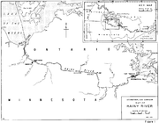
Rainy River (Minnesota-Ontario)
Encyclopedia
United States
The United States of America is a federal constitutional republic comprising fifty states and a federal district...
-Canada
Canada
Canada is a North American country consisting of ten provinces and three territories. Located in the northern part of the continent, it extends from the Atlantic Ocean in the east to the Pacific Ocean in the west, and northward into the Arctic Ocean...
border separating northern Minnesota
Minnesota
Minnesota is a U.S. state located in the Midwestern United States. The twelfth largest state of the U.S., it is the twenty-first most populous, with 5.3 million residents. Minnesota was carved out of the eastern half of the Minnesota Territory and admitted to the Union as the thirty-second state...
and Northwestern Ontario
Northwestern Ontario
Northwestern Ontario is the region within the Canadian province of Ontario which lies north and west of Lake Superior, and west of Hudson Bay and James Bay. It includes most of subarctic Ontario. Its western boundary is the Canadian province of Manitoba, which disputed Ontario's claim to the...
.
It issues from the west side of Rainy Lake
Rainy Lake
Rainy Lake is a relatively large freshwater lake that straddles the border between the United States and Canada. The Rainy River issues from the west side of the lake and is harnessed to make hydroelectricity for US and Canadian locations. The U.S...
(French: lac à la Pluie; Ojibwe: Gojijii-zaaga'igan) and flows generally west-northwest, between International Falls, Minnesota
International Falls, Minnesota
International Falls is a city in and the county seat of Koochiching County, Minnesota, United States. The population was 6,424 at the 2010 census....
and Fort Frances, Ontario
Fort Frances, Ontario
Fort Frances is a town in, and the seat of, Rainy River District in Northwestern Ontario, Canada. The population as of the 2006 census was 8,103 and Fort Frances' population peaked in 1971 at 9,947...
, and between Baudette, Minnesota
Baudette, Minnesota
-Demographics:As of the census of 2000, there were 1,104 people, 490 households, and 271 families residing in the city. The population density was 334.1 people per square mile . There were 540 housing units at an average density of 163.4 per square mile...
and Rainy River, Ontario
Rainy River, Ontario
The Canadian town of Rainy River is situated on the Ontario-Minnesota border, along the Rainy River opposite Baudette, Minnesota, USA, and southeast of the Lake of the Woods...
. It enters the southern end of Lake of the Woods
Lake of the Woods
Lake of the Woods is a lake occupying parts of the Canadian provinces of Ontario and Manitoba and the U.S. state of Minnesota. It separates a small land area of Minnesota from the rest of the United States. The Northwest Angle and the town of Angle Township can only be reached from the rest of...
approximately 12 miles (19.3 km) northwest of Baudette. It is used for hydroelectricity
Hydroelectricity
Hydroelectricity is the term referring to electricity generated by hydropower; the production of electrical power through the use of the gravitational force of falling or flowing water. It is the most widely used form of renewable energy...
at International Falls. The town of Rainy River, Ontario
Rainy River, Ontario
The Canadian town of Rainy River is situated on the Ontario-Minnesota border, along the Rainy River opposite Baudette, Minnesota, USA, and southeast of the Lake of the Woods...
was named after it; the Couchiching First Nation
Couchiching First Nation
The Couchiching First Nation is a Saulteaux First Nation in the Canadian province of Ontario, who live on the Couchiching 16A and Agency 1 reserves in the Rainy River District near Fort Frances....
and Koochiching County, Minnesota
Koochiching County, Minnesota
Koochiching County is a county located in the U.S. state of Minnesota. As of 2010, the population was 13,311. Its county seat is International Falls. A portion of the Bois Forte Indian Reservation is in the county. A small part of Voyageurs National Park extends into its northeast...
are named after the Ojibwa's name for the river and the lake. The drainage basin of the river stretches east to the height of land about 100 kilometres (62.1 mi) west of Lake Superior
Lake Superior
Lake Superior is the largest of the five traditionally-demarcated Great Lakes of North America. It is bounded to the north by the Canadian province of Ontario and the U.S. state of Minnesota, and to the south by the U.S. states of Wisconsin and Michigan. It is the largest freshwater lake in the...
, where it was the southeast corner of the huge tract of land granted to the Hudson's Bay Company
Hudson's Bay Company
The Hudson's Bay Company , abbreviated HBC, or "The Bay" is the oldest commercial corporation in North America and one of the oldest in the world. A fur trading business for much of its existence, today Hudson's Bay Company owns and operates retail stores throughout Canada...
in 1670. It ultimately drains through the Winnipeg River
Winnipeg River
The Winnipeg River is a Canadian river which flows from Lake of the Woods in the province of Ontario to Lake Winnipeg in Manitoba. This river is long from the Norman Dam in Kenora to its mouth at Lake Winnipeg. Its watershed is in area, mainly in Canada. About of this area is in northern...
, Lake Winnipeg
Lake Winnipeg
Lake Winnipeg is a large, lake in central North America, in the province of Manitoba, Canada, with its southern tip about north of the city of Winnipeg...
and the Nelson River
Nelson River
The Nelson River is a river of north-central North America, in the Canadian province of Manitoba. Its full length is , it has mean discharge of , and has a drainage basin of , of which is in the United States...
into Hudson Bay
Hudson Bay
Hudson Bay , sometimes called Hudson's Bay, is a large body of saltwater in northeastern Canada. It drains a very large area, about , that includes parts of Ontario, Quebec, Saskatchewan, Alberta, most of Manitoba, southeastern Nunavut, as well as parts of North Dakota, South Dakota, Minnesota,...
.
The Baudette-Rainy River International Bridge
Baudette-Rainy River International Bridge
The Baudette – Rainy River International Bridge is an international bridge connecting Rainy River, Ontario, Canada with Baudette, Minnesota, USA across the Rainy River....
and the Fort Frances-International Falls International Bridge
Fort Frances-International Falls International Bridge
The Fort Frances – International Falls International Bridge is a privately owned international toll bridge connecting the towns of Fort Frances, Ontario and International Falls, Minnesota across the Rainy River....
both cross the Rainy River.
The Ontario and Rainy River Railway, opened in 1901 and now part of Canadian National, follows the river on the Canadian side.
See also
- Pigeon RiverPigeon River (Minnesota-Ontario)The Pigeon River forms part of the US-Canada border between the State of Minnesota and the Province of Ontario west of Lake Superior. In pre-industrial times the river was a waterway of great importance for transportation and trade.-Geography:...
- List of Minnesota rivers
- List of international border rivers
- List of Ontario rivers
- Rainy LakeRainy LakeRainy Lake is a relatively large freshwater lake that straddles the border between the United States and Canada. The Rainy River issues from the west side of the lake and is harnessed to make hydroelectricity for US and Canadian locations. The U.S...
- Lake sturgeonLake sturgeonThe lake sturgeon is a North American temperate freshwater fish, one of about 20 species of sturgeon. Like other sturgeons, this species is an evolutionarily ancient bottomfeeder with a partly cartilaginous skeleton and skin bearing rows of bony plates...