
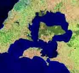
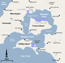
Western Port
Encyclopedia
Western Port, is sometimes called "Western Port Bay", is a large tidal bay
in southern Victoria
, Australia
opening into Bass Strait
. It is the second largest bay in Victoria. Geographically, it is dominated by the two large islands; French Island and Phillip Island. Contrary to its name, it lies to the east of the larger Port Phillip
, and is separated from it by the Mornington Peninsula
. It is visited by Australian Fur Seals, whale
s and dolphin
s, as well as many migratory
wader
s and seabird
s. It is listed under the Ramsar Convention
as a wetland of international significance.
The area around the bay and the two main islands were originally part of the Boonwurrung
nation's territory prior to European settlement. Western Port was first seen by Europeans in 1798 when an exploration crew in a whaleboat
led by George Bass
, journeyed south from Sydney
to explore Australia's south eastern coastline. Due in most part to a lack of food, the expedition was halted, spending two weeks in Western Port before returning to Sydney. As it was the most westerly charted point at the time, it was named Western Port, however it actually lies in the eastern half of Victoria and to the east of the larger Port Phillip
and Greater Melbourne
.
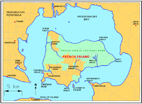
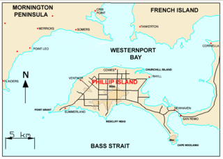
The bay is home to the three Marine National Parks—French Island
, Churchill Island
and Yaringa
,
while the land adjacent to the north is largely used for farming purposes including cattle and wineries. Today the bay is mostly used for recreation, however there is also a military base (HMAS Cerberus), shipping and oil production facilities adjoining the bay. Western Port is around one hour from Melbourne by car and a small number of holiday villages with sandy swimming beaches lie on its shores.
 Prior to European settlement, the Bunurong
people lived around Western Port living off shellfish, mutton birds and plantlife. The bay was discovered by Europeans in 1797, when George Bass
received permission from Governor Hunter in Sydney
to sail a whaleboat
along the unexplored section of coast south of Botany Bay
. On such a rough stretch of water, Bass could not get more than halfway through the strait now known as Bass Strait. This voyage led to the discovery of Western Port, so named because of its situation relative to every other known harbour on the coast at that time (the area from Point Hicks
to Cape Howe
), even though it lies to the east of Port Phillip
and the city of Melbourne
.
In the early 19th century, the port played a role in the struggle between Britain and France. Soldiers and convicts from Sydney were ordered to form a camp at Western Port to deter possible occupation by the French. It was only after the end of World War II
that serious consideration was given to the development of the port, and its flat shores north of Stony and Crib Points have become a centre for heavy industry.
by the rising sea in the Holocene
period; the Western Port sunkland now forms an extensive tidal bay. The waters of Western Port cover an area of 680 km² of which 270 km² are exposed as mud flats at low tide. The topography of Western Port is dominated by two large islands: French Island
and Phillip Island. The coastline, including that of the islands, is some 263 km. The bay and its islands are criss-crossed by seven seismically active fault lines and experiences numerous minor earthquakes every year.
In the northern reaches, several rivers and creeks drain into the bay and flow through extensive mangroves, mudflats and sand banks before being channelled either side of French Island and into the open water in the southern reaches around Phillip Island. Several natural river paths and channels provide access for boats to the northern reaches, however, this is highly dependent on the tides and local knowledge is essential. Some of the major tributaries of Western Port are Bunyip River
, Lang Lang River
, Bass River
, Cardinia Creek
, Redbill Creek, Mosquito Creek, Brella Creek and Tankerton Creek. Until the mid 20th century, the Koo-Wee-Rup Swamp adjoined the bay in the north, covering an area of 30–40 thousand hectares, extending inland to present day Pakenham, prior to cultivation of the land by early settlers. The mangroves in the northern reaches are the only remnants of this swamp today.
 Western Port contains two large islands and several small ones; in approximate order of size:
s including colonial ascidians, sponges and coral
s. Mudflats and mangrove
swamps around the northern end of the bay support a large number of invertebrates that are an important food source for waders and visiting migratory birds. French Island is home to migratory
wader
s, Australian Pelican
s, Short-tailed Shearwater
rookeries, and many other significant fauna species. The bay has been identified as a 623 km2 Important Bird Area
(IBA) by BirdLife International
because it regularly supports small numbers of critically endangered
Orange-bellied Parrot
s, over 1% of the world populations of Far Eastern Curlew
s, Red-necked Stint
s and Pied Oystercatcher
s, and declining numbers of vulnerable
Fairy Tern
s.
Phillip Island
Penguin Reserve has the largest colony of Little Penguins in Victoria
as well as a major colony of Short-tailed Shearwaters, with breeding Hooded Plover
s and Peregrine Falcon
s. Seal Rock off Phillip Island is home to the largest colony of Australian Fur Seals and a breeding site of Kelp Gull
s and Sooty Oystercatcher
s. San Remo's marine community is a rich assemblage of marine biota listed under the State Flora and Fauna Guarantee Act, 1988. The bay is listed under the Ramsar Convention
for its internationally important wetlands. http://www.dse.vic.gov.au/dse/nrenpr.nsf/FID/-5BDC05F727469CE44A2568A3001C3C7C?OpenDocument
into the western section of the bay, giving access to the region's port facilities. The town of Hastings
is the main boat landing in the bay.
There are boat launching ramps at:
Stony Point -Concrete 3 lane ramp, 2 holding jetties, All Tides
Blind Bight -Tarmac Single lane ramp, Holding Jetty, High Tide
Corinella -Concrete 2 lane ramp, 2 Holding jetties, All Tides
Hastings - Concrete 4 lane ramp, Holding Jetty, All Tides
There are also ramps at Tooradin, Newhaven, Cowes, Warneet, Lang Lang, Grantville, Flinders, and Rhyll (Phillip Island).
A ferry runs between Cowes, Tankerton And Stony Point at certain times ( Check timetable at destinations) during the year.
Accommodation is available on both Phillip Island and French Island.
steel processing works and the major Royal Australian Navy
training base, HMAS Cerberus. Holden Australia's proving ground is located just east of Western Port.
Current development plans for the Port at Hastings would see it become the major shipping port for container and bulk freight in and out of Victoria. Substantial opposition to the development has been raised by local communities concerned with the scale of the development and it's impact upon the fragile ecosystem of the bay. Blue Wedges
provide a voice for many of the objections raised by concerned locals.
However, you may carry fin-fish on board your boat within park boundaries if you caught the fish outside the parks and you may also carry but not use, a fishing rod or spear gun. You may also have abalone or rock lobster associated equipment on board the boat provided that you are travelling straight through the park by the shortest practicable route.
Headlands and bays
Headlands and bays are two related features of the coastal environment.- Geology and geography :Headlands and bays are often found on the same coastline. A bay is surrounded by land on three sides, whereas a headland is surrounded by water on three sides. Headlands are characterized by high,...
in southern Victoria
Victoria (Australia)
Victoria is the second most populous state in Australia. Geographically the smallest mainland state, Victoria is bordered by New South Wales, South Australia, and Tasmania on Boundary Islet to the north, west and south respectively....
, Australia
Australia
Australia , officially the Commonwealth of Australia, is a country in the Southern Hemisphere comprising the mainland of the Australian continent, the island of Tasmania, and numerous smaller islands in the Indian and Pacific Oceans. It is the world's sixth-largest country by total area...
opening into Bass Strait
Bass Strait
Bass Strait is a sea strait separating Tasmania from the south of the Australian mainland, specifically the state of Victoria.-Extent:The International Hydrographic Organization defines the limits of the Bass Strait as follows:...
. It is the second largest bay in Victoria. Geographically, it is dominated by the two large islands; French Island and Phillip Island. Contrary to its name, it lies to the east of the larger Port Phillip
Port Phillip
Port Phillip Port Phillip Port Phillip (also commonly referred to as Port Phillip Bay or (locally) just The Bay, is a large bay in southern Victoria, Australia; it is the location of Melbourne. Geographically, the bay covers and the shore stretches roughly . Although it is extremely shallow for...
, and is separated from it by the Mornington Peninsula
Mornington Peninsula
The Mornington Peninsula is a peninsula located south-east of Melbourne in Victoria, Australia. It is surrounded by Port Phillip to the west, Western Port to the east and Bass Strait to the south, and is connected to the mainland in the north. Geographically, the peninsula begins its protrusion...
. It is visited by Australian Fur Seals, whale
Whale
Whale is the common name for various marine mammals of the order Cetacea. The term whale sometimes refers to all cetaceans, but more often it excludes dolphins and porpoises, which belong to suborder Odontoceti . This suborder also includes the sperm whale, killer whale, pilot whale, and beluga...
s and dolphin
Dolphin
Dolphins are marine mammals that are closely related to whales and porpoises. There are almost forty species of dolphin in 17 genera. They vary in size from and , up to and . They are found worldwide, mostly in the shallower seas of the continental shelves, and are carnivores, mostly eating...
s, as well as many migratory
Bird migration
Bird migration is the regular seasonal journey undertaken by many species of birds. Bird movements include those made in response to changes in food availability, habitat or weather. Sometimes, journeys are not termed "true migration" because they are irregular or in only one direction...
wader
Wader
Waders, called shorebirds in North America , are members of the order Charadriiformes, excluding the more marine web-footed seabird groups. The latter are the skuas , gulls , terns , skimmers , and auks...
s and seabird
Seabird
Seabirds are birds that have adapted to life within the marine environment. While seabirds vary greatly in lifestyle, behaviour and physiology, they often exhibit striking convergent evolution, as the same environmental problems and feeding niches have resulted in similar adaptations...
s. It is listed under the Ramsar Convention
Ramsar Convention
The Ramsar Convention is an international treaty for the conservation and sustainable utilization of wetlands, i.e., to stem the progressive encroachment on and loss of wetlands now and in the future, recognizing the fundamental ecological functions of wetlands and their economic, cultural,...
as a wetland of international significance.
The area around the bay and the two main islands were originally part of the Boonwurrung
Bunurong
The Bunurong are Indigenous Australians of the Kulin nation, who occupy South-Central Victoria, Australia. Prior to European settlement, they lived as all people of the Kulin nation lived, sustainably on the land, predominantly as hunters and gatherers, for tens of thousands of years...
nation's territory prior to European settlement. Western Port was first seen by Europeans in 1798 when an exploration crew in a whaleboat
Whaleboat
A whaleboat is a type of open boat that is relatively narrow and pointed at both ends, enabling it to move either forwards or backwards equally well. It was originally developed for whaling, and later became popular for work along beaches, since it does not need to be turned around for beaching or...
led by George Bass
George Bass
George Bass was a British naval surgeon and explorer of Australia.-Early years:He was born on 30 January 1771 at Aswarby, a hamlet near Sleaford, Lincolnshire, the son of a tenant farmer, George Bass, and a local beauty named Sarah Nee Newman. His father died in 1777 when Bass was 6...
, journeyed south from Sydney
Sydney
Sydney is the most populous city in Australia and the state capital of New South Wales. Sydney is located on Australia's south-east coast of the Tasman Sea. As of June 2010, the greater metropolitan area had an approximate population of 4.6 million people...
to explore Australia's south eastern coastline. Due in most part to a lack of food, the expedition was halted, spending two weeks in Western Port before returning to Sydney. As it was the most westerly charted point at the time, it was named Western Port, however it actually lies in the eastern half of Victoria and to the east of the larger Port Phillip
Port Phillip
Port Phillip Port Phillip Port Phillip (also commonly referred to as Port Phillip Bay or (locally) just The Bay, is a large bay in southern Victoria, Australia; it is the location of Melbourne. Geographically, the bay covers and the shore stretches roughly . Although it is extremely shallow for...
and Greater Melbourne
Melbourne
Melbourne is the capital and most populous city in the state of Victoria, and the second most populous city in Australia. The Melbourne City Centre is the hub of the greater metropolitan area and the Census statistical division—of which "Melbourne" is the common name. As of June 2009, the greater...
.
The bay is home to the three Marine National Parks—French Island
French Island National Park
French Island is the largest coastal island of Victoria, Australia, located in Western Port, 61 km southeast of Melbourne. In 1997 about 70 per cent of the island was declared the French Island National Park, and is listed in the register of the National Estate...
, Churchill Island
Churchill Island Marine National Park
The Churchill Island Marine National Park is a marine park in Western Port, Victoria, Australia. It is located south of Rhyll, on the north-eastern shore of Phillip Island, in Western Port. It extends from Long Point south of the town of Rhyll, to the northern point of Churchill Island and along...
and Yaringa
Yaringa Marine National Park
The Yaringa Marine National Park is a marine park in Western Port, Victoria, Australia.It is located between the mainland and Quail Island Nature Conservation Reserve, about 9 km south-west of Tooradin. The area comprises saltmarsh, mangroves, sheltered intertidal mudflats, subtidal soft sediments...
,
while the land adjacent to the north is largely used for farming purposes including cattle and wineries. Today the bay is mostly used for recreation, however there is also a military base (HMAS Cerberus), shipping and oil production facilities adjoining the bay. Western Port is around one hour from Melbourne by car and a small number of holiday villages with sandy swimming beaches lie on its shores.
History
Bunurong
The Bunurong are Indigenous Australians of the Kulin nation, who occupy South-Central Victoria, Australia. Prior to European settlement, they lived as all people of the Kulin nation lived, sustainably on the land, predominantly as hunters and gatherers, for tens of thousands of years...
people lived around Western Port living off shellfish, mutton birds and plantlife. The bay was discovered by Europeans in 1797, when George Bass
George Bass
George Bass was a British naval surgeon and explorer of Australia.-Early years:He was born on 30 January 1771 at Aswarby, a hamlet near Sleaford, Lincolnshire, the son of a tenant farmer, George Bass, and a local beauty named Sarah Nee Newman. His father died in 1777 when Bass was 6...
received permission from Governor Hunter in Sydney
Sydney
Sydney is the most populous city in Australia and the state capital of New South Wales. Sydney is located on Australia's south-east coast of the Tasman Sea. As of June 2010, the greater metropolitan area had an approximate population of 4.6 million people...
to sail a whaleboat
Whaleboat
A whaleboat is a type of open boat that is relatively narrow and pointed at both ends, enabling it to move either forwards or backwards equally well. It was originally developed for whaling, and later became popular for work along beaches, since it does not need to be turned around for beaching or...
along the unexplored section of coast south of Botany Bay
Botany Bay
Botany Bay is a bay in Sydney, New South Wales, a few kilometres south of the Sydney central business district. The Cooks River and the Georges River are the two major tributaries that flow into the bay...
. On such a rough stretch of water, Bass could not get more than halfway through the strait now known as Bass Strait. This voyage led to the discovery of Western Port, so named because of its situation relative to every other known harbour on the coast at that time (the area from Point Hicks
Point Hicks
Point Hicks, formerly called Cape Everard, is a coastal headland on the eastern coast of Victoria, Australia, located within the Croajingolong National Park.- Name :...
to Cape Howe
Cape Howe
Cape Howe is a coastal headland in Australia, forming the south-eastern end of the Black-Allen Line, the border between New South Wales and Victoria.-History:...
), even though it lies to the east of Port Phillip
Port Phillip
Port Phillip Port Phillip Port Phillip (also commonly referred to as Port Phillip Bay or (locally) just The Bay, is a large bay in southern Victoria, Australia; it is the location of Melbourne. Geographically, the bay covers and the shore stretches roughly . Although it is extremely shallow for...
and the city of Melbourne
Melbourne
Melbourne is the capital and most populous city in the state of Victoria, and the second most populous city in Australia. The Melbourne City Centre is the hub of the greater metropolitan area and the Census statistical division—of which "Melbourne" is the common name. As of June 2009, the greater...
.
In the early 19th century, the port played a role in the struggle between Britain and France. Soldiers and convicts from Sydney were ordered to form a camp at Western Port to deter possible occupation by the French. It was only after the end of World War II
World War II
World War II, or the Second World War , was a global conflict lasting from 1939 to 1945, involving most of the world's nations—including all of the great powers—eventually forming two opposing military alliances: the Allies and the Axis...
that serious consideration was given to the development of the port, and its flat shores north of Stony and Crib Points have become a centre for heavy industry.
Geography
Formerly a major river drainage system, it was inundated together with Port PhillipPort Phillip
Port Phillip Port Phillip Port Phillip (also commonly referred to as Port Phillip Bay or (locally) just The Bay, is a large bay in southern Victoria, Australia; it is the location of Melbourne. Geographically, the bay covers and the shore stretches roughly . Although it is extremely shallow for...
by the rising sea in the Holocene
Holocene
The Holocene is a geological epoch which began at the end of the Pleistocene and continues to the present. The Holocene is part of the Quaternary period. Its name comes from the Greek words and , meaning "entirely recent"...
period; the Western Port sunkland now forms an extensive tidal bay. The waters of Western Port cover an area of 680 km² of which 270 km² are exposed as mud flats at low tide. The topography of Western Port is dominated by two large islands: French Island
French Island National Park
French Island is the largest coastal island of Victoria, Australia, located in Western Port, 61 km southeast of Melbourne. In 1997 about 70 per cent of the island was declared the French Island National Park, and is listed in the register of the National Estate...
and Phillip Island. The coastline, including that of the islands, is some 263 km. The bay and its islands are criss-crossed by seven seismically active fault lines and experiences numerous minor earthquakes every year.
In the northern reaches, several rivers and creeks drain into the bay and flow through extensive mangroves, mudflats and sand banks before being channelled either side of French Island and into the open water in the southern reaches around Phillip Island. Several natural river paths and channels provide access for boats to the northern reaches, however, this is highly dependent on the tides and local knowledge is essential. Some of the major tributaries of Western Port are Bunyip River
Bunyip River
The Bunyip River is a river in southern Victoria, Australia to the east of Melbourne. It flows into Western Port. The river formerly flowed into the Koo-Wee-Rup Swamp, the largest wetlands in Victoria, covering an area of 40,000 hectares, before flowing into Western Port.The Bunyip River starts...
, Lang Lang River
Lang Lang River
The Wang Lang river is a relatively short coastal river located in Gippsland, Victoria, Australia. The river headwaters are in the Strzelecki Ranges, in the East Poowong valley north of the town of Korumburra, flowing northwest, then west before entering Western Port, near the town of Lang...
, Bass River
Bass River (Victoria)
The Bass River is a relatively short coastal river located in the Bass Coast Shire of Gippsland, Victoria, Australia. The river headwaters are in the Strzelecki Ranges, north of the town of Korumburra, flowing west, then west-southwest before entering Western Port, near the town of Bass.It was...
, Cardinia Creek
Cardinia Creek
Cardinia Creek is a fresh water creek which flows from Cardinia Reservoir into Western Port Bay south east of Melbourne.It forms the boundary between the City of Casey and the Shire of Cardinia. It runs through the town of Beaconsfield, Victoria and is home to much native flora and fauna.-...
, Redbill Creek, Mosquito Creek, Brella Creek and Tankerton Creek. Until the mid 20th century, the Koo-Wee-Rup Swamp adjoined the bay in the north, covering an area of 30–40 thousand hectares, extending inland to present day Pakenham, prior to cultivation of the land by early settlers. The mangroves in the northern reaches are the only remnants of this swamp today.
Islands
- French Island - 170 km² (population: 70)
- Phillip Island - 100 km² (population: 7,000)
- Middle Spit - exposed at low tide
- Quail IslandQuail Island, VictoriaQuail Island is the third largest island in Western Port . It is uninhabited, the entirety of it being gazetted as Quail Island Nature Conservation Reserve. It is offshore from Warneet and can be accessed by boat. There are two seasonal dams located in the centre and the Southern Brown Bandicoot...
- Tortoise Head Bank - exposed at low tide
- Churchill Island - 57 ha
- Chinaman IslandChinaman IslandChinaman Island is an uninhabited island located in Western Port, Victoria, south-eastern Australia. It lies about 4 km north of French Island. It considered to be of State botanical and zoological significance. It is accessible at low tide by fording a small tidal creek.-External links:*...
- Elizabeth IslandElizabeth Island (Victoria)Elizabeth Island lies just south of French Island in Western Port, Victoria, south-eastern Australia. It is separated from French Island by intertidal mudflats and a small channel. It is in area and is an unincorporated area of Victoria...
- Sandstone Island
- Reef Island
- Long Island
- Shnapper Rock
- Pelican Island
- Barrallier Island
- Rams Island
- Joe IslandJoe Island (Victoria)Joe Island is a very small, uninhabited island located in Western Port Bay, Victoria, Australia, approximately 1 km north of French Island.-References:...
Flora
Western Port supports a mosaic of habitat types including underwater seagrass beds, intertidal rock platforms, sandy beaches, intertidal mudflats, tidal channels, saltmarshes and mangroves. The coastline around Phillip Island is of State significance because of its remnant coastal tussock grasslands and dune scrub, a rare vegetation community in Victoria.Fauna
Western Port consists of rocky platforms, sandy beaches and marine habitats. It is home to a diverse range of invertebrateInvertebrate
An invertebrate is an animal without a backbone. The group includes 97% of all animal species – all animals except those in the chordate subphylum Vertebrata .Invertebrates form a paraphyletic group...
s including colonial ascidians, sponges and coral
Coral
Corals are marine animals in class Anthozoa of phylum Cnidaria typically living in compact colonies of many identical individual "polyps". The group includes the important reef builders that inhabit tropical oceans and secrete calcium carbonate to form a hard skeleton.A coral "head" is a colony of...
s. Mudflats and mangrove
Mangrove
Mangroves are various kinds of trees up to medium height and shrubs that grow in saline coastal sediment habitats in the tropics and subtropics – mainly between latitudes N and S...
swamps around the northern end of the bay support a large number of invertebrates that are an important food source for waders and visiting migratory birds. French Island is home to migratory
Bird migration
Bird migration is the regular seasonal journey undertaken by many species of birds. Bird movements include those made in response to changes in food availability, habitat or weather. Sometimes, journeys are not termed "true migration" because they are irregular or in only one direction...
wader
Wader
Waders, called shorebirds in North America , are members of the order Charadriiformes, excluding the more marine web-footed seabird groups. The latter are the skuas , gulls , terns , skimmers , and auks...
s, Australian Pelican
Australian Pelican
The Australian Pelican is a large water bird, widespread on the inland and coastal waters of Australia and New Guinea, also in Fiji, parts of Indonesia and as a vagrant to New Zealand.-Taxonomy:...
s, Short-tailed Shearwater
Short-tailed Shearwater
The Short-tailed Shearwater or Slender-billed Shearwater , also called Yolla or Moonbird, and commonly known as the muttonbird in Australia, is the most abundant seabird species in Australian waters, and is one of the few Australian native birds in which the chicks are commercially harvested...
rookeries, and many other significant fauna species. The bay has been identified as a 623 km2 Important Bird Area
Important Bird Area
An Important Bird Area is an area recognized as being globally important habitat for the conservation of bird populations. Currently there are about 10,000 IBAs worldwide. The program was developed and sites are identified by BirdLife International...
(IBA) by BirdLife International
BirdLife International
BirdLife International is a global Partnership of conservation organisations that strives to conserve birds, their habitats and global biodiversity, working with people towards sustainability in the use of natural resources...
because it regularly supports small numbers of critically endangered
Critically endangered
Version 2010.3 of the IUCN Red List of Threatened Species identified 3744 Critically Endangered species, subspecies and varieties, stocks and subpopulations.Critically Endangered by kingdom:*1993 Animalia*2 Fungi*1745 Plantae*4 Protista-References:...
Orange-bellied Parrot
Orange-bellied Parrot
The Orange-bellied Parrot is a small broad-tailed parrot endemic to southern Australia, and one of only two species of parrot which migrate. The adult male is distinguished by its bright grass-green upperparts, yellow underparts and orange belly patch. The adult female and juvenile are duller...
s, over 1% of the world populations of Far Eastern Curlew
Far Eastern Curlew
The Far Eastern Curlew or Eastern Curlew is a large shorebird most similar in appearance to the Long-billed Curlew, but slightly larger. It is mostly brown in color, differentiated from other curlews by its plain, unpatterned brown underwing...
s, Red-necked Stint
Red-necked Stint
The Red-necked Stint is a small migratory wader.- Description :These birds are among the smallest of waders, very similar to the Little Stint, Calidris minuta, with which they were once considered conspecific...
s and Pied Oystercatcher
Pied Oystercatcher
The Pied Oystercatcher, Haematopus longirostris, is a species of oystercatcher. It is a wading bird native to Australia and commonly found on its coastline. The similar South Island Pied Oystercatcher The Pied Oystercatcher, Haematopus longirostris, is a species of oystercatcher. It is a wading...
s, and declining numbers of vulnerable
Vulnerable species
On 30 January 2010, the IUCN Red List of Threatened Species identified 9694 Vulnerable species, subspecies and varieties, stocks and sub-populations.-References:...
Fairy Tern
Fairy Tern
The Fairy Tern is a small tern which occurs in the southwestern Pacific.There are three subspecies:* Australian Fairy Tern, Sterna nereis nereis - breeds in Australia...
s.
Phillip Island
Phillip Island Important Bird Area
The Phillip Island Important Bird Area comprises a 20 km2 strip of coastline along the south and west coasts of Phillip Island, Victoria, in south-eastern Australia.-Description:...
Penguin Reserve has the largest colony of Little Penguins in Victoria
Victoria (Australia)
Victoria is the second most populous state in Australia. Geographically the smallest mainland state, Victoria is bordered by New South Wales, South Australia, and Tasmania on Boundary Islet to the north, west and south respectively....
as well as a major colony of Short-tailed Shearwaters, with breeding Hooded Plover
Hooded Plover
The Hooded Dotterel or Hooded Plover is a species of bird in the Charadriidae family. It is endemic to southern Australia and Tasmania. There are two recognized subspecies, both of which are classifed as Endangered....
s and Peregrine Falcon
Peregrine Falcon
The Peregrine Falcon , also known as the Peregrine, and historically as the Duck Hawk in North America, is a widespread bird of prey in the family Falconidae. A large, crow-sized falcon, it has a blue-gray back, barred white underparts, and a black head and "moustache"...
s. Seal Rock off Phillip Island is home to the largest colony of Australian Fur Seals and a breeding site of Kelp Gull
Kelp Gull
The Kelp Gull , also known as the Dominican Gull, breeds on coasts and islands through much of the southern hemisphere. The race L. d. vetula occurs around southern Africa, and nominate L. d...
s and Sooty Oystercatcher
Sooty Oystercatcher
The Sooty Oystercatcher, Haematopus fuliginosus, is a species of oystercatcher. It is a wading bird native to Australia and commonly found on its coastline. It prefers rocky coastlines, but will occasionally live in estuaries....
s. San Remo's marine community is a rich assemblage of marine biota listed under the State Flora and Fauna Guarantee Act, 1988. The bay is listed under the Ramsar Convention
Ramsar Convention
The Ramsar Convention is an international treaty for the conservation and sustainable utilization of wetlands, i.e., to stem the progressive encroachment on and loss of wetlands now and in the future, recognizing the fundamental ecological functions of wetlands and their economic, cultural,...
for its internationally important wetlands. http://www.dse.vic.gov.au/dse/nrenpr.nsf/FID/-5BDC05F727469CE44A2568A3001C3C7C?OpenDocument
Parklands
- Land:
- Coolart Wetlands and Homestead ReserveCoolart Wetlands and Homestead ReserveThe Coolart Wetlands and Homestead Reserve, or just Coolart, is an 87.5 ha estate on the Western Port coast of the Mornington Peninsula of Victoria, south-eastern Australia, about 70 km south-east of Melbourne. It comprises a late 19th century mansion-like homestead and surrounding...
- French Island National ParkFrench Island National ParkFrench Island is the largest coastal island of Victoria, Australia, located in Western Port, 61 km southeast of Melbourne. In 1997 about 70 per cent of the island was declared the French Island National Park, and is listed in the register of the National Estate...
- Langwarrin Flora and Fauna Reserve
- Mornington Peninsula National ParkMornington Peninsula National ParkMornington Peninsula is a national park in Victoria , 77 km south of Melbourne on the Mornington Peninsula. It is one of Victoria's most popular and most loved parks, protecting lots of the area's natural attractions and providing an important habitat for many forms of wildlife.-See also:*...
- Marine:
- French Island National ParkFrench Island National ParkFrench Island is the largest coastal island of Victoria, Australia, located in Western Port, 61 km southeast of Melbourne. In 1997 about 70 per cent of the island was declared the French Island National Park, and is listed in the register of the National Estate...
- 2,800ha - Yaringa Marine National ParkYaringa Marine National ParkThe Yaringa Marine National Park is a marine park in Western Port, Victoria, Australia.It is located between the mainland and Quail Island Nature Conservation Reserve, about 9 km south-west of Tooradin. The area comprises saltmarsh, mangroves, sheltered intertidal mudflats, subtidal soft sediments...
- 980ha - Churchill Island Marine National ParkChurchill Island Marine National ParkThe Churchill Island Marine National Park is a marine park in Western Port, Victoria, Australia. It is located south of Rhyll, on the north-eastern shore of Phillip Island, in Western Port. It extends from Long Point south of the town of Rhyll, to the northern point of Churchill Island and along...
- 670ha
Recreation on Phillip Island
- PenguinLittle PenguinThe Little Penguin is the smallest species of penguin. The penguin, which usually grows to an average of in height and in length , is found on the coastlines of southern Australia and New Zealand, with possible records from Chile.Apart from Little Penguins, they have several common names...
Reserve - visited at dusk to watch the penguins return to their burrows in the sand dunes - SealFur sealFur seals are any of nine species of pinnipeds in the Otariidae family. One species, the northern fur seal inhabits the North Pacific, while seven species in the Arctocephalus genus are found primarily in the Southern hemisphere...
Rocks - viewed through binoculars - KoalaKoalaThe koala is an arboreal herbivorous marsupial native to Australia, and the only extant representative of the family Phascolarctidae....
Conservation Centre - Bird watching
- Scenic Flights from Philip Island Airport ( Located on Cape Woolamai)
Recreation on French Island
- Bushwalking or bird observing; bush orchid and fishing areas; horse riding, bike rides, and deep water fishing
- Koala habitat
- Camping
Shipping and Boating
Deep channels lead from Bass StraitBass Strait
Bass Strait is a sea strait separating Tasmania from the south of the Australian mainland, specifically the state of Victoria.-Extent:The International Hydrographic Organization defines the limits of the Bass Strait as follows:...
into the western section of the bay, giving access to the region's port facilities. The town of Hastings
Hastings, Victoria
Hastings is a suburb on the Mornington Peninsula, Victoria, Australia, as a part of the urban enclave on Westernport comprising Hastings, Bittern, Crib Point, Tyabb, and Somerville. Its Local Government Area is the Shire of Mornington Peninsula...
is the main boat landing in the bay.
There are boat launching ramps at:
Stony Point -Concrete 3 lane ramp, 2 holding jetties, All Tides
Blind Bight -Tarmac Single lane ramp, Holding Jetty, High Tide
Corinella -Concrete 2 lane ramp, 2 Holding jetties, All Tides
Hastings - Concrete 4 lane ramp, Holding Jetty, All Tides
There are also ramps at Tooradin, Newhaven, Cowes, Warneet, Lang Lang, Grantville, Flinders, and Rhyll (Phillip Island).
A ferry runs between Cowes, Tankerton And Stony Point at certain times ( Check timetable at destinations) during the year.
Accommodation is available on both Phillip Island and French Island.
Industry
Western Port has several industrial complexes, including a BlueScope SteelBlueScope Steel
BlueScope Steel is a flat product steel producer with operations in Australia, New Zealand, Asia, the Pacific and North America. It was spun off from BHP Billiton in 2002 as BHP Steel and renamed BlueScope Steel on 17 November 2003...
steel processing works and the major Royal Australian Navy
Royal Australian Navy
The Royal Australian Navy is the naval branch of the Australian Defence Force. Following the Federation of Australia in 1901, the ships and resources of the separate colonial navies were integrated into a national force: the Commonwealth Naval Forces...
training base, HMAS Cerberus. Holden Australia's proving ground is located just east of Western Port.
Current development plans for the Port at Hastings would see it become the major shipping port for container and bulk freight in and out of Victoria. Substantial opposition to the development has been raised by local communities concerned with the scale of the development and it's impact upon the fragile ecosystem of the bay. Blue Wedges
Blue Wedges
Blue Wedges is a conservation organisation in conflict with Australia's Victorian government policy to deepen shipping channels in Port Phillip and the large scale development of Ramsar listed Westernport...
provide a voice for many of the objections raised by concerned locals.
Regulations
For the protection of the marine environment, a number of activities are prohibited within the boundaries of Victoria's Marine National Parks and Marine Sanctuaries. No fishing, netting, spearing, taking or killing of marine life. All methods of fishing, from the shore or sea, are prohibited. No taking or damaging of animals, plants and objects or artefacts. There are strong penalties under the National Parks Act for fishing in Marine National Parks and Sanctuaries. All offenses can by reported to the Department of Primary Industries on 133 474 (within Australia)However, you may carry fin-fish on board your boat within park boundaries if you caught the fish outside the parks and you may also carry but not use, a fishing rod or spear gun. You may also have abalone or rock lobster associated equipment on board the boat provided that you are travelling straight through the park by the shortest practicable route.