

Weather Station Kurt
Encyclopedia
Automatic weather station
An automatic weather station is an automated version of the traditional weather station, either to save human labour or to enable measurements from remote areas...
, erected by a German
Germany
Germany , officially the Federal Republic of Germany , is a federal parliamentary republic in Europe. The country consists of 16 states while the capital and largest city is Berlin. Germany covers an area of 357,021 km2 and has a largely temperate seasonal climate...
U-boat
U-boat
U-boat is the anglicized version of the German word U-Boot , itself an abbreviation of Unterseeboot , and refers to military submarines operated by Germany, particularly in World War I and World War II...
crew in Northern Labrador
Labrador
Labrador is the distinct, northerly region of the Canadian province of Newfoundland and Labrador. It comprises the mainland portion of the province, separated from the island of Newfoundland by the Strait of Belle Isle...
, Newfoundland
Newfoundland and Labrador
Newfoundland and Labrador is the easternmost province of Canada. Situated in the country's Atlantic region, it incorporates the island of Newfoundland and mainland Labrador with a combined area of . As of April 2011, the province's estimated population is 508,400...
in October 1943. This was the only armed German military operation on land in North America during the Second World War.
Background
Weather in the Northern HemisphereNorthern Hemisphere
The Northern Hemisphere is the half of a planet that is north of its equator—the word hemisphere literally means “half sphere”. It is also that half of the celestial sphere north of the celestial equator...
predominantly moves from west to east. This gave the Allies
Allies
In everyday English usage, allies are people, groups, or nations that have joined together in an association for mutual benefit or to achieve some common purpose, whether or not explicit agreement has been worked out between them...
an important advantage. The Allied network of weather stations in North America, Greenland and Iceland allowed the Allies to make more accurate weather forecasts than the Germans. German meteorologists had weather reports sent by U-boats and weather ship
Weather ship
A weather ship was a ship stationed in the ocean as a platform for surface and upper air meteorological observations for use in weather forecasting. They were primarily located in the north Atlantic and north Pacific oceans, reporting via radio...
s, such as the Lauenburg
German weather ship Lauenburg
The Lauenburg was a German weather ship used in the early years of the Second World War to provide weather reports for German shipping, particularly German U-boats...
, operating in the North Atlantic. They also had reports from clandestine weather stations in remote parts of the Arctic and readings collected over the Atlantic by specially equipped weather aircraft. However, the ships and clandestine stations were easily captured by the Allies during the early part of the war. Data from aircraft was incomplete as they were limited in range and susceptible to Allied attack. Regular weather reporting by U-boats put them at risk as it broke radio silence
Radio silence
In telecommunications, radio silence is a status in which all fixed or mobile radio stations in an area are asked to stop transmitting for safety or security reasons.The term "radio station" may include anything capable of transmitting a radio signal....
, allowing the Allies to locate them and track their movements by radio triangulation.
Development and Deployment
For more information, the Germans developed the Wetter-Funkgerät Land weather station. It was designed by Dr. Ernest Ploetze and Edwin Stoebe. Twenty-six were manufactured by SiemensSiemens AG
Siemens AG is a German multinational conglomerate company headquartered in Munich, Germany. It is the largest Europe-based electronics and electrical engineering company....
. The WFL had an array of measuring instruments, a telemetry
Telemetry
Telemetry is a technology that allows measurements to be made at a distance, usually via radio wave transmission and reception of the information. The word is derived from Greek roots: tele = remote, and metron = measure...
system and a 150 Watt, Lorenz 150 FK-type transmitter. It had 10 cylindrical canisters, each 1 metres (3.3 ft) by c.47cm diameter (1.5 metres (4.9 ft) circumference) and weighing around 100 kilograms (220 lb). One canister contained the instruments; it was attached to a 10 metres (33 ft) antenna mast. A second, shorter mast carried an anemometer
Anemometer
An anemometer is a device for measuring wind speed, and is a common weather station instrument. The term is derived from the Greek word anemos, meaning wind, and is used to describe any airspeed measurement instrument used in meteorology or aerodynamics...
and wind vane
Weather vane
A weather vane is an instrument for showing the direction of the wind. They are typically used as an architectural ornament to the highest point of a building....
. The other canisters contained nickel-cadmium batteries
Nickel-cadmium battery
The nickel–cadmium battery ' is a type of rechargeable battery using nickel oxide hydroxide and metallic cadmium as electrodes....
that powered the system. The WFL would broadcast weather readings every three hours during a two minute transmission on 3940 kHz
Hertz
The hertz is the SI unit of frequency defined as the number of cycles per second of a periodic phenomenon. One of its most common uses is the description of the sine wave, particularly those used in radio and audio applications....
. The system could work for up to six months, depending on the number of battery canisters.
Fourteen stations were deployed in Arctic and sub-Arctic regions (Greenland, Bear Island
Bear Island (Nunavut)
The uninhabited Bear Island is a Baffin Island offshore island located in the Canadian Arctic Archipelago in the territory of Nunavut. The island lies in the Labrador Sea a few kilometres north of its confluence with Frobisher Bay...
, Spitsbergen
Spitsbergen
Spitsbergen is the largest and only permanently populated island of the Svalbard archipelago in Norway. Constituting the western-most bulk of the archipelago, it borders the Arctic Ocean, the Norwegian Sea and the Greenland Sea...
and Franz Josef Land
Franz Josef Land
Franz Josef Land, Franz Joseph Land, or Francis Joseph's Land is an archipelago located in the far north of Russia. It is found in the Arctic Ocean north of Novaya Zemlya and east of Svalbard, and is administered by Arkhangelsk Oblast. Franz Josef Land consists of 191 ice-covered islands with a...
) and five were placed around the Barents Sea. Two were intended for North America. One was deployed in 1943 by the U-boat U-537, but the submarine carrying the other - U-867 - was sunk.
On September 18, 1943, U-537, commanded by Kapitänleutnant Peter Schrewe, departed from Kiel
Kiel
Kiel is the capital and most populous city in the northern German state of Schleswig-Holstein, with a population of 238,049 .Kiel is approximately north of Hamburg. Due to its geographic location in the north of Germany, the southeast of the Jutland peninsula, and the southwestern shore of the...
, Germany on her first combat patrol. It carried WFL-26, codenamed "Kurt", a meteorologist, Dr Kurt Sommermeyer, and his assistant, Walter Hildebrant. En-route, the U-boat was caught in a storm and a large breaker produced significant damage, this included leaks in the hull and the submarine's quadruple anti-aircraft cannon being ripped off, leaving it defenseless on the surface against Allied aircraft.
On October 22, the U-537 arrived at Martin Bay in Northern Labrador, at a position . This is close to Cape Chidley
Cape Chidley
Cape Chidley is a headland located on the eastern shore of Killiniq Island, Canada at the northeastern tip of the Labrador Peninsula.-Cape Chidley:...
at the north-eastern tip of the Labrador Peninsula
Labrador Peninsula
The Labrador Peninsula is a large peninsula in eastern Canada. It is bounded by the Hudson Bay to the west, the Hudson Strait to the north, the Labrador Sea to the east, and the Gulf of Saint Lawrence to the south-east...
. Schrewe selected a site this far north as he believed this would minimize the risk of the station being discovered by Inuit
Inuit
The Inuit are a group of culturally similar indigenous peoples inhabiting the Arctic regions of Canada , Denmark , Russia and the United States . Inuit means “the people” in the Inuktitut language...
people. Within an hour of dropping anchor a scouting party had located a suitable site and soon after Dr. Sommermeyer, his assistant and ten sailors disembarked to install the station. Armed lookouts were posted on nearby high ground and other crew set to repair the submarine's storm damage.
For concealment, the station was camouflaged. Empty, American cigarette packets were left around the site, to help deceive any Allied personnel that chanced upon it, and was marked as the property of the non-existent "Canadian Meteor Service" (although, at the time, the area was part of the Dominion of Newfoundland
Dominion of Newfoundland
The Dominion of Newfoundland was a British Dominion from 1907 to 1949 . The Dominion of Newfoundland was situated in northeastern North America along the Atlantic coast and comprised the island of Newfoundland and Labrador on the continental mainland...
, not part of Canada). The crew worked through the night to install Kurt and repair their U-boat. They finished just 28 hours after dropping anchor and, after confirming the station was working, U-537 departed. It undertook a combat patrol in the area of the Grand Banks of Newfoundland during which it survived three attacks by Canadian aircraft, but sank no ships. The submarine reached port at Lorient
Lorient
Lorient, or L'Orient, is a commune and a seaport in the Morbihan department in Brittany in north-western France.-History:At the beginning of the 17th century, merchants who were trading with India had established warehouses in Port-Louis...
, France on December 8, after 70 days at sea.
Rediscovery
The station was forgotten until the late 1970s, when a retired Siemens engineer, Franz Selinger, who was writing a history of the company, went through Sommermeyer's papers and learned of the station's existence. He contacted Canadian Department of National DefenceDepartment of National Defence (Canada)
The Department of National Defence , frequently referred to by its acronym DND, is the department within the government of Canada with responsibility for all matters concerning the defence of Canada...
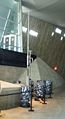
historian W.A.B. Douglas, who went to the site with a team in 1981 and found the station still there, although canisters had been opened and components strewn about the site. Weather Station Kurt was brought to Ottawa and is now on display at the Canadian War Museum
Canadian War Museum
The Canadian War Museum is Canada’s national museum of military history. Located in Ottawa, Ontario, the museum covers all facets of Canada’s military past, from the first recorded instances of death by armed violence in Canadian history several thousand years ago to the country’s most recent...
.
External links
- German Description of Weather Station Kurt, including a wartime picture of the deployed station
- English Description of Weather Station Kurt