
Voronya Cave
Encyclopedia
The Krubera Cave is the deepest known cave
on Earth
. It is located in the Arabika Massif
of the Gagrinsky Range of the Western Caucasus
, in the Gagra district
of Abkhazia
, Georgia
’s breakaway republic.
The difference in the altitude of the cave's entrance and its deepest explored point is 2191 +/- 20 m (7,188.3 +/- 65.6 ft). It became the deepest-known cave in the world in 2001 when the expedition of the Ukrainian
Speleological Association reached a depth of 1710 m (5,610.2 ft) which exceeded the depth of the previously deepest cave, Lamprechtsofen, in the Austrian Alps, by 80 m. In 2004, for the first time in the history of speleology
, the Ukrainian Speleological Association expedition reached a depth greater than 2,000 m, and explored the cave to -2080 m. The current maximum depth of 2,191 m was reached during a 46 m dive by Gennadiiy Samokhin into the terminal sump
during the expedition of the Ukrainian Speleological Association in August–September 2007. The cave remains the only known cave on Earth deeper than 2,000 metres.
speleologists during the 1980s
due to a number of crows nesting in the entrance pit, and then remained in the literature and media as a second name for the cave. The original name "Krubera" had been assigned to the cave by Georgian speleologists who explored the entrance pit in 1960. This name was given after the noted Russian geographer Alexander Kruber
. The name "Krubera Cave" thus has a priority.
 The Arabika Massif
, the home of Krubera (Voronya) Cave, is one of the largest high-mountain limestone
karst
massif
s in the Western Caucasus. It is composed of Lower Cretaceous and Upper Jurassic limestones that dip continuously southwest to the Black Sea
and plunge below the modern sea level.
To the northwest, north, northeast, and east, Arabika is bordered by the deeply incised canyons of Sandripsh, Kutushara, Gega and Bzyb rivers. The Bzyb River
separates Arabika from the adjacent Bzybsky Massif, another outstanding karst area with many deep caves, including the Snezhnaja-Mezhonogo-Iljuzia System (-1753 m) and Pantjukhina Cave (-1508 m). To the southwest, Arabika borders the Black Sea
.
The Arabika Massif has a prominent high central sector with elevations above the tree line at ~1800–1900 m (5,905.5–6,233.6 ft). This is an area of classical glaciokarst
ic landscape, with numerous glacial trough valleys and cirques, with ridges and peaks between them. The bottoms of trough valleys and karst fields lie at elevations of 2000–2350 m (6,561.7–7,710 ft), and ridges and peaks rise to 2500–2700 m (8,202.1–8,858.3 ft). The highest peak is the Peak of Speleologists (2705 m (8,874.7 ft)) but the dominant summit is a typical pyramidal horn of the Arabika Mount (2695 m (8,841.9 ft)). Some middle- to low-altitude ridges covered with forest lie between the central sector and the Black Sea
. A plateau-like middle-altitude outlier of the massif in its south sector is Mamzdyshkha, with part of the plateau slightly emerging above the tree line.
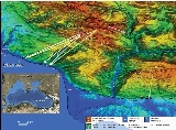
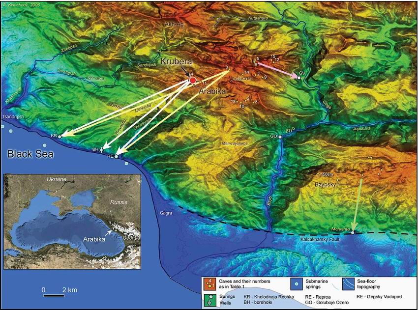
Among several hundred caves known in the Arabika Massif, fifteen have been explored deeper than 400 m and five deeper than 1,000 m (shown in Figure 1).
Krubera Cave is located at 2,256 m asl in the Ortobalagan Valley, a perfectly shaped, relatively shallow, glacial trough of the sub-Caucasian
stretch, which holds the advanced position in the Arabika's central sector relative to the seashore. Since 1980, Ukrainian cavers have been undertaking systematic efforts in exploring deep caves in the Ortobalagan Valley, resulting in exploration of the Krubera Cave to its current depth and of the Arabikskaja System to depth of -1110 m. The latter consists of Kuybushevskaya Cave (also spelled as Kujbyshevskaja; −1,110 m) and Genrikhova Bezdna Cave (−965 m to the junction with Kujbyshevskaja). Another deep cave in the valley, located in its very upper part and explored by Moldavian
and Ukrainian cavers is Berchilskaya Cave, 500 m (1,640.4 ft) deep. All large caves of the Ortobalagan Valley likely belong to a single hydrological system, connected to large springs at the Black Sea
shore. The direct physical connection of Krubera Cave with the Arabikaskaja System is a sound possibility, although not yet physically realized.
crest (Figure 2) but the caves are controlled by longitudinal, transverse, and oblique fractures and faults and comprise complex winding patterns in the plan view, remaining largely within and near the anticlinal crest zone. The caves are predominantly combinations of vadose shafts and steep meandering passages, although in places they cut apparently old fossil passages at different levels (e.g., at -2100 m in Kujbyshevskaja and Krubera cavs, -1200 m and -980 m in the non-Kujbyshevskaja branch of Krubera Cave, etc.). The deep parts of Krubera display a more pervasive conduit pattern with a mixture of phreatic
morphology, characteristic of the zone of high-gradient floods, which can be up to 400 m above the low-flow water table, and vadose downcutting elements that are observed even below the water table.
The core part of the Arabika Massif is composed of the Upper Jurassic succession resting on the Bajocian
Porphyritic
Series, which includes sandstones, clays and conglomerates at the top, and tuff, tuff sandstone
s, conglomerates
and breccia
, porphyry
and lava
. The Porphyritic series forms the non-karstic basement of Arabika, which is exposed only on the northern and eastern outskirts, locally in the bottoms of the Kutushara and Gega River valleys. In the central part of Arabika the Cretaceous
cover (Valanginian
and Hauterivian
limestones, marl
s and sandstones) is retained only in a few ridges and peaks, but it lies intact through the low-altitude ridges to the south-west of the central part. There the Cretaceous succession includes Barremian
and Aptian
–Cenomanian
limestones and marly limestones with abundant concretions of black chert.
The Upper Jurassic succession begins with thin-bedded Kimmeridgian
–Oxfordian
chert
y limestones, marls, sandstones and clay
s, which are identified in the lower part of Krubera Cave. Above lies the thick Tithonian
succession of thick-bedded limestones with marly and sandy varieties. Sandy limestones are particularly abundant through the upper 1,000 m sections of deep caves of the Ortobalagan Valley.
The tectonic structure of Arabika is dominated by the axis of the large sub-Caucasian anticline (oriented NW–SE), with the gently dipping southwestern mega-flank, complicated by several low-order folds, and steeply dipping northeastern flank (Figure 3). The axis of the anticline roughly coincides with the ridge bordering the Gelgeluk Valley to the north. Located on the southwestern flank of the major anticline is another large one (Berchil'sky), in which the crest is breached by the Ortobalagan Valley. There are several smaller sub-parallel anticlines and syncline
s farther southwest, between the Berchil' Ridge and the coast.
The plicative dislocation structure of the massif is severely complicated by faults, with the fault-block structure strongly controlling both cave development and groundwater flow. Major faults of the sub-Caucasian orientation delineate several large elongated blocks that experienced uplift with different rates during Pliocene
and Pleistocene
. This had a pronounced effect on the development of deep groundwater circulation and of Krubera Cave in particular. Both longitudinal and transverse faults and related fracture zones play a role in guiding groundwater flow; the latter guide flow across the strike of major plicative dislocations, from the central sector toward the Black Sea
.
town.
Some boreholes located along the shore of the Black Sea
yield karstic groundwater from depths of 40–280 m below sea level. Other much deeper boreholes tapped low-salinity karstic waters at depths of 500 and 1,750 m in the Khashupse Valley near Tsandripsh and 2,250 m near Gagra. This suggests the existence of a deep karst system and vigorous karst groundwater circulation at depth.
Submarine springs are known in the Arabika area, emerging from the floor of the Black Sea
in front of the massif. Shallow springs at depths of 5–7 m can be reached by free dive near Tsandripsh. Kiknadze (1979) reported submarine springs near the eastern part of Gagra at depth of 25–30 m and Buachidze and Meliva (1967) revealed submarine discharge at depths up to −400 m by hydrochemical profiling. Recently an outstanding feature of the sea floor topography near Arabika has been revealed from a digital bathymetric
map that combines depth soundings and high-resolution marine gravity data. This is a huge submarine depression in front of the Zhovekvara River mouth, which has dimensions of about 5 x 9 km and a maximum depth of about 380 m (1,246.7 ft). The Arabika Submarine Depression is a closed feature with internal vertical relief of about 120 m (393.7 ft) (measured from its lowest rim) separated from the abyssal slope by the bar at a depth of about 260 m (853 ft). It has steep northern and northeastern slopes (on the side of the massif) and gentle south and southwestern slopes. Its formation is apparently karstic. Presently this depression seems to be a focus of submarine discharge of the karst systems of Arabika.
The speleological explorations and a series of dye tracing
experiments conducted during the 1980s under the coordination of Alexander Klimchouk have radically changed previous notions of the hydrogeology of Arabika, revealed its outstanding speleological perspectives and strongly stimulated further efforts for exploration of deep caves. Tracers injected in the Kujbyshevskaja Cave and the Iljukhina System were detected in the Kholodnaja Rechka and Reproa springs, proving groundwater flow to the south-southwest across major tectonic structures over a distance of 13–16 km as the crow flies (Figure 1). The tracer from Kujbyshevskaja Cave was also detected in a borehole located between these two springs, which yields groundwater from a depth of 200 m (656.2 ft) below sea level. This has been interpreted as an indication of the connection of the cave with the submarine discharge. The large "Central Karst Hydrologic System", which encompasses most of the southeastern flank of the Arabika anticline, had been identified in this way. The system became the deepest in the world with its overall vertical range of about 2500 m (8,202.1 ft) (measuring to the borehole water-bearing horizon) or even 2700 m (8,858.3 ft) (measuring to the deepest reported submarine discharge points).
Another tracer was injected in the Moskovskaja Cave (−970 m) and detected at the Gegsky Vodopad spring, indicating the presence of a karst hydrologic system comprising the northeastern flank of the Arabika anticline (the "Northern System"). No connections have been revealed with yet another major spring, Goluboje Ozero in the Bzyb River canyon, although it apparently drains a large area of the eastern sector of the massif (the hypothetical "Eastern Karst Hydrological System"). It is not clear where Sarma Cave (−1,550 m) drains to, Goluboje Ozero to the southeast or Reproa to the southwest, at the shore.
The results of the dye-tracing tests demonstrated that groundwater flow is not subordinate to the fold structure but is largely controlled by faults that cut across the strike of major folds, and that the large part of the central sector of Arabika is hydraulically connected to the springs along the seashore and with submarine discharge points.
Krubera Cave has an extremely steep profile and reveals a huge thickness of the vadose zone. The lower boundary of the vadose zone (the top of the phreatic zone) is at an elevation of about 110 m (360.9 ft) at low flow, which suggests a low overall hydraulic gradient of 0.007-0.008. Low-TDS
groundwater is tapped by boreholes in the shore area at depths of 40–280, 500, 1,750, and 2,250 m below sea level, which suggests the existence of a deep flow system with vigorous flow. Submarine discharge along the Arabika coast is reported at depths up to ~400 m b.s.l.
It is difficult to interpret these facts in terms of the development of karst systems controlled by contemporary sea level, or within the range of its Pleistocene fluctuations (up to −150 m). In combination with the existence of the Arabika Submarine Depression, all these facts point to the possibility that karst systems in Arabika could have originated in response to the Messinian salinity crisis
(5.96–5.33 Ma) when the Black Sea
(Eastern Paratethys
) could have almost dried up, as did the adjacent Mediterranean, where the dramatic sea level drop of ~1,500 m is well established.
, who published several works about the massif. During 1909–10 the well-known Russian karst scientist Alexander Kruber, a founder of karst science in Russia, performed some field studies in Arabika. He published his observations in a series of Arabika-specific papers and through several major monograph
s. During the subsequent 50 years no special studies were undertaken of the karst and caves in the region, although the karst of Arabika was referred to in many works dealing with regional geology and hydrogeology.
, Georgian speleologists led by L. Maruashvili began exploring caves in the high sector of the massif. Among several other caves, they made the first exploration of an open-mouthed 60 m shaft in the Ortobalagan Valley and named it after Alexander Kruber. The first explorers were stopped by impassable squeezes at −95 m in a meandering passage which led off from the foot of the entrance shaft. The cave remained largely neglected over next 20 years, although occasionally visited by cavers from various caving clubs. Before 1980 there were no caves deeper than 310 m (1,017.1 ft) known in Arabika.
In the Ortobalagan Valley, the Ukrainian cavers made breakthroughs in Kujbyshevskaja Cave at −160 m and pushed it to -1110 m by 1986 through a series of massive boulder chokes. They broke through an impassable squeeze at −120 m in Genrikhova Bezdna Cave and eventually connected it to Kujbyshevskaja at −956 m in 1987. The resultant system has been named the Arabikskaja System.
From 1982 onwards, the Kiev cavers started systematically working in Krubera Cave, located less than 200 metres from the Kujbyshevskaja entrance, hoping to connect with the Arabikskaja System and increase its total depth by 60 m. Exploration progressed slowly because critically tight meanders between the pits required enormous amounts of work to widen them to a passable size. The cave was pushed to −340 m during 1982–1987. Two "windows" in a vertical shaft at depths of 220–250 m were documented on the cave map but remained unexplored. During this time the cave received its second, alternative name (Crows') Cave, owing to the number of crows nesting in the entrance shaft.
In 1999, the expedition of the Ukrainian Speleological Associations (Ukr.S.A.) led by Yury Kasjan made a major breakthrough in Krubera Cave by discovering and exploring two branches behind the windows at a depth of 220–250 m. These branches stretched in two different directions. The "Main Branch" was explored to −740 m and the "Nekujbyshevskaja Branch" to −500 m.
In 2000, the Main Branch was quickly pushed by the multi-stage expedition of the Ukr.S.A. in August to −1,200 m and in September to −1,410 m.
In January 2001, the Ukr.S.A. expedition explored the cave to -1710 m making it the deepest cave in the world. For the first time in the history of speleology, the deepest cave in the world had been established outside of the western Europe. Since 2001, the Krubera explorations by the Ukr.S.A. have been undertaken within the frame of the multi-year project named "The Call of the Abyss", coordinated by A. Klimchouk, Y. Kasjan, G. Samokhin and K. Markovskoy. Besides the Ukrainian speleologists, cavers from many countries such as France, Spain, Russia, Moldova, Bulgaria, Great Britain, Ireland, Israel and Lithuania have taken part in different expeditions of the Ukr.S.A.
Cave
A cave or cavern is a natural underground space large enough for a human to enter. The term applies to natural cavities some part of which is in total darkness. The word cave also includes smaller spaces like rock shelters, sea caves, and grottos.Speleology is the science of exploration and study...
on Earth
Earth
Earth is the third planet from the Sun, and the densest and fifth-largest of the eight planets in the Solar System. It is also the largest of the Solar System's four terrestrial planets...
. It is located in the Arabika Massif
Arabika Massif
Arabika Massif is a glacially eroded karst outcropping of the Gagra Range, Abkhazia in the West Caucasus, by the city of Gagra. Highest elevation: .The world's deepest cave, Voronya Cave, is located in the massif....
of the Gagrinsky Range of the Western Caucasus
Western Caucasus
The Western Caucasus is a western region of the Caucasus in Southern Russia, extending from the Black Sea to Mount Elbrus.-World Heritage Site:...
, in the Gagra district
Gagra district
Gagra District is a district of Abkhazia. It corresponds to the Georgian district by the same name. In medieval times, it was known as the southern part of Sadzen. It is located in the western part of Abkhazia, and the river Psou serves as a border with Krasnodar Kray of Russia. Its capital is...
of Abkhazia
Abkhazia
Abkhazia is a disputed political entity on the eastern coast of the Black Sea and the south-western flank of the Caucasus.Abkhazia considers itself an independent state, called the Republic of Abkhazia or Apsny...
, Georgia
Georgia (country)
Georgia is a sovereign state in the Caucasus region of Eurasia. Located at the crossroads of Western Asia and Eastern Europe, it is bounded to the west by the Black Sea, to the north by Russia, to the southwest by Turkey, to the south by Armenia, and to the southeast by Azerbaijan. The capital of...
’s breakaway republic.
The difference in the altitude of the cave's entrance and its deepest explored point is 2191 +/- 20 m (7,188.3 +/- 65.6 ft). It became the deepest-known cave in the world in 2001 when the expedition of the Ukrainian
Ukraine
Ukraine is a country in Eastern Europe. It has an area of 603,628 km², making it the second largest contiguous country on the European continent, after Russia...
Speleological Association reached a depth of 1710 m (5,610.2 ft) which exceeded the depth of the previously deepest cave, Lamprechtsofen, in the Austrian Alps, by 80 m. In 2004, for the first time in the history of speleology
Speleology
Speleology is the scientific study of caves and other karst features, their make-up, structure, physical properties, history, life forms, and the processes by which they form and change over time...
, the Ukrainian Speleological Association expedition reached a depth greater than 2,000 m, and explored the cave to -2080 m. The current maximum depth of 2,191 m was reached during a 46 m dive by Gennadiiy Samokhin into the terminal sump
Sump (cave)
Sump is a term used in caving to describe a submerged passage in a cave. A sump may be static, with no inward or outward flow, or active, with continuous through-flow...
during the expedition of the Ukrainian Speleological Association in August–September 2007. The cave remains the only known cave on Earth deeper than 2,000 metres.
Naming
"Voronya Cave" means "Crows' Cave" in Russian. This name was used as a slang name by KievKiev
Kiev or Kyiv is the capital and the largest city of Ukraine, located in the north central part of the country on the Dnieper River. The population as of the 2001 census was 2,611,300. However, higher numbers have been cited in the press....
speleologists during the 1980s
1980s
File:1980s decade montage.png|thumb|400px|From left, clockwise: The first Space Shuttle, Columbia, lifted off in 1981; American President Ronald Reagan and Soviet leader Mikhail Gorbachev eased tensions between the two superpowers, leading to the end of the Cold War; The Fall of the Berlin Wall in...
due to a number of crows nesting in the entrance pit, and then remained in the literature and media as a second name for the cave. The original name "Krubera" had been assigned to the cave by Georgian speleologists who explored the entrance pit in 1960. This name was given after the noted Russian geographer Alexander Kruber
Alexander Kruber
Alexander Kruber was a Soviet geographer, professor, the founder of the Russian and Soviet karstology.Alexander Kruber was born in Istra , Russia. He graduated from the Moscow University in 1897...
. The name "Krubera Cave" thus has a priority.
Location and background
Arabika Massif
Arabika Massif is a glacially eroded karst outcropping of the Gagra Range, Abkhazia in the West Caucasus, by the city of Gagra. Highest elevation: .The world's deepest cave, Voronya Cave, is located in the massif....
, the home of Krubera (Voronya) Cave, is one of the largest high-mountain limestone
Limestone
Limestone is a sedimentary rock composed largely of the minerals calcite and aragonite, which are different crystal forms of calcium carbonate . Many limestones are composed from skeletal fragments of marine organisms such as coral or foraminifera....
karst
KARST
Kilometer-square Area Radio Synthesis Telescope is a Chinese telescope project to which FAST is a forerunner. KARST is a set of large spherical reflectors on karst landforms, which are bowlshaped limestone sinkholes named after the Kras region in Slovenia and Northern Italy. It will consist of...
massif
Massif
In geology, a massif is a section of a planet's crust that is demarcated by faults or flexures. In the movement of the crust, a massif tends to retain its internal structure while being displaced as a whole...
s in the Western Caucasus. It is composed of Lower Cretaceous and Upper Jurassic limestones that dip continuously southwest to the Black Sea
Black Sea
The Black Sea is bounded by Europe, Anatolia and the Caucasus and is ultimately connected to the Atlantic Ocean via the Mediterranean and the Aegean seas and various straits. The Bosphorus strait connects it to the Sea of Marmara, and the strait of the Dardanelles connects that sea to the Aegean...
and plunge below the modern sea level.
To the northwest, north, northeast, and east, Arabika is bordered by the deeply incised canyons of Sandripsh, Kutushara, Gega and Bzyb rivers. The Bzyb River
Bzyb River
Soviet President Nikita Khrushchev once proposed a major dam and hydroelectric power generation facility on the Bzyb River, since his favourite resort was located near the mouth of the river at Pitsunda. However, this proposal was ruled out by his experts who opined that a dam built on the Bzyb...
separates Arabika from the adjacent Bzybsky Massif, another outstanding karst area with many deep caves, including the Snezhnaja-Mezhonogo-Iljuzia System (-1753 m) and Pantjukhina Cave (-1508 m). To the southwest, Arabika borders the Black Sea
Black Sea
The Black Sea is bounded by Europe, Anatolia and the Caucasus and is ultimately connected to the Atlantic Ocean via the Mediterranean and the Aegean seas and various straits. The Bosphorus strait connects it to the Sea of Marmara, and the strait of the Dardanelles connects that sea to the Aegean...
.
The Arabika Massif has a prominent high central sector with elevations above the tree line at ~1800–1900 m (5,905.5–6,233.6 ft). This is an area of classical glaciokarst
Glaciokarst
Glaciokarst is a karst landscape that was glaciated during the cold periods of the Pleistocene and displays major landforms of glacial influence. For this reason karstification can be pre- and/or post- Pleistocene, this is not easy to classifiy...
ic landscape, with numerous glacial trough valleys and cirques, with ridges and peaks between them. The bottoms of trough valleys and karst fields lie at elevations of 2000–2350 m (6,561.7–7,710 ft), and ridges and peaks rise to 2500–2700 m (8,202.1–8,858.3 ft). The highest peak is the Peak of Speleologists (2705 m (8,874.7 ft)) but the dominant summit is a typical pyramidal horn of the Arabika Mount (2695 m (8,841.9 ft)). Some middle- to low-altitude ridges covered with forest lie between the central sector and the Black Sea
Black Sea
The Black Sea is bounded by Europe, Anatolia and the Caucasus and is ultimately connected to the Atlantic Ocean via the Mediterranean and the Aegean seas and various straits. The Bosphorus strait connects it to the Sea of Marmara, and the strait of the Dardanelles connects that sea to the Aegean...
. A plateau-like middle-altitude outlier of the massif in its south sector is Mamzdyshkha, with part of the plateau slightly emerging above the tree line.
Among several hundred caves known in the Arabika Massif, fifteen have been explored deeper than 400 m and five deeper than 1,000 m (shown in Figure 1).
Krubera Cave is located at 2,256 m asl in the Ortobalagan Valley, a perfectly shaped, relatively shallow, glacial trough of the sub-Caucasian
Caucasus
The Caucasus, also Caucas or Caucasia , is a geopolitical region at the border of Europe and Asia, and situated between the Black and the Caspian sea...
stretch, which holds the advanced position in the Arabika's central sector relative to the seashore. Since 1980, Ukrainian cavers have been undertaking systematic efforts in exploring deep caves in the Ortobalagan Valley, resulting in exploration of the Krubera Cave to its current depth and of the Arabikskaja System to depth of -1110 m. The latter consists of Kuybushevskaya Cave (also spelled as Kujbyshevskaja; −1,110 m) and Genrikhova Bezdna Cave (−965 m to the junction with Kujbyshevskaja). Another deep cave in the valley, located in its very upper part and explored by Moldavian
Moldova
Moldova , officially the Republic of Moldova is a landlocked state in Eastern Europe, located between Romania to the West and Ukraine to the North, East and South. It declared itself an independent state with the same boundaries as the preceding Moldavian Soviet Socialist Republic in 1991, as part...
and Ukrainian cavers is Berchilskaya Cave, 500 m (1,640.4 ft) deep. All large caves of the Ortobalagan Valley likely belong to a single hydrological system, connected to large springs at the Black Sea
Black Sea
The Black Sea is bounded by Europe, Anatolia and the Caucasus and is ultimately connected to the Atlantic Ocean via the Mediterranean and the Aegean seas and various straits. The Bosphorus strait connects it to the Sea of Marmara, and the strait of the Dardanelles connects that sea to the Aegean...
shore. The direct physical connection of Krubera Cave with the Arabikaskaja System is a sound possibility, although not yet physically realized.
Geology
The Ortobalagan Valley extends along the crest of the Berchil'sky anticline, which gently dips northwest. The cave entrances are aligned along the anticlinalAnticline
In structural geology, an anticline is a fold that is convex up and has its oldest beds at its core. The term is not to be confused with antiform, which is a purely descriptive term for any fold that is convex up. Therefore if age relationships In structural geology, an anticline is a fold that is...
crest (Figure 2) but the caves are controlled by longitudinal, transverse, and oblique fractures and faults and comprise complex winding patterns in the plan view, remaining largely within and near the anticlinal crest zone. The caves are predominantly combinations of vadose shafts and steep meandering passages, although in places they cut apparently old fossil passages at different levels (e.g., at -2100 m in Kujbyshevskaja and Krubera cavs, -1200 m and -980 m in the non-Kujbyshevskaja branch of Krubera Cave, etc.). The deep parts of Krubera display a more pervasive conduit pattern with a mixture of phreatic
Phreatic
The term phreatic is used in Earth sciences to refer to matters relating to ground water below the water table . The term 'phreatic surface' indicates the location where the pore water pressure is under atmospheric conditions...
morphology, characteristic of the zone of high-gradient floods, which can be up to 400 m above the low-flow water table, and vadose downcutting elements that are observed even below the water table.
The core part of the Arabika Massif is composed of the Upper Jurassic succession resting on the Bajocian
Bajocian
In the geologic timescale, the Bajocian is an age or stage in the Middle Jurassic. It lasted from approximately 171.6 Ma to around 167.7 Ma . The Bajocian age succeeds the Aalenian age and precedes the Bathonian age....
Porphyritic
Porphyritic
Porphyritic is an adjective used in geology, specifically for igneous rocks, for a rock that has a distinct difference in the size of the crystals, with at least one group of crystals obviously larger than another group...
Series, which includes sandstones, clays and conglomerates at the top, and tuff, tuff sandstone
Sandstone
Sandstone is a sedimentary rock composed mainly of sand-sized minerals or rock grains.Most sandstone is composed of quartz and/or feldspar because these are the most common minerals in the Earth's crust. Like sand, sandstone may be any colour, but the most common colours are tan, brown, yellow,...
s, conglomerates
Conglomerate (geology)
A conglomerate is a rock consisting of individual clasts within a finer-grained matrix that have become cemented together. Conglomerates are sedimentary rocks consisting of rounded fragments and are thus differentiated from breccias, which consist of angular clasts...
and breccia
Breccia
Breccia is a rock composed of broken fragments of minerals or rock cemented together by a fine-grained matrix, that can be either similar to or different from the composition of the fragments....
, porphyry
Porphyry (geology)
Porphyry is a variety of igneous rock consisting of large-grained crystals, such as feldspar or quartz, dispersed in a fine-grained feldspathic matrix or groundmass. The larger crystals are called phenocrysts...
and lava
Lava
Lava refers both to molten rock expelled by a volcano during an eruption and the resulting rock after solidification and cooling. This molten rock is formed in the interior of some planets, including Earth, and some of their satellites. When first erupted from a volcanic vent, lava is a liquid at...
. The Porphyritic series forms the non-karstic basement of Arabika, which is exposed only on the northern and eastern outskirts, locally in the bottoms of the Kutushara and Gega River valleys. In the central part of Arabika the Cretaceous
Cretaceous
The Cretaceous , derived from the Latin "creta" , usually abbreviated K for its German translation Kreide , is a geologic period and system from circa to million years ago. In the geologic timescale, the Cretaceous follows the Jurassic period and is followed by the Paleogene period of the...
cover (Valanginian
Valanginian
In the geologic timescale, the Valanginian is an age or stage of the Early or Lower Cretaceous. It spans between 140.2 ± 3.0 Ma and 136.4 ± 2.0 Ma...
and Hauterivian
Hauterivian
The Hauterivian is, in the geologic timescale, an age in the Early Cretaceous epoch or a stage in the Lower Cretaceous series. It spans the time between 136.4 ± 2 Ma and 130 ± 1.5 Ma...
limestones, marl
Marl
Marl or marlstone is a calcium carbonate or lime-rich mud or mudstone which contains variable amounts of clays and aragonite. Marl was originally an old term loosely applied to a variety of materials, most of which occur as loose, earthy deposits consisting chiefly of an intimate mixture of clay...
s and sandstones) is retained only in a few ridges and peaks, but it lies intact through the low-altitude ridges to the south-west of the central part. There the Cretaceous succession includes Barremian
Barremian
The Barremian is an age in the geologic timescale between 130.0 ± 1.5 Ma and 125.0 ± 1.0 Ma). It is a subdivision of the Early Cretaceous epoch...
and Aptian
Aptian
The Aptian is an age in the geologic timescale or a stage in the stratigraphic column. It is a subdivision of the Early or Lower Cretaceous epoch or series and encompasses the time from 125.0 ± 1.0 Ma to 112.0 ± 1.0 Ma , approximately...
–Cenomanian
Cenomanian
The Cenomanian is, in the ICS' geological timescale the oldest or earliest age of the Late Cretaceous epoch or the lowest stage of the Upper Cretaceous series. An age is a unit of geochronology: it is a unit of time; the stage is a unit in the stratigraphic column deposited during the corresponding...
limestones and marly limestones with abundant concretions of black chert.
The Upper Jurassic succession begins with thin-bedded Kimmeridgian
Kimmeridgian
In the geologic timescale, the Kimmeridgian is an age or stage in the Late or Upper Jurassic epoch or series. It spans the time between 155.7 ± 4 Ma and 150.8 ± 4 Ma . The Kimmeridgian follows the Oxfordian and precedes the Tithonian....
–Oxfordian
Oxfordian stage
The Oxfordian is, in the ICS' geologic timescale, the earliest age of the Late Jurassic epoch, or the lowest stage of the Upper Jurassic series. It spans the time between 161.2 ± 4 Ma and 155.7 ± 4 Ma...
chert
Chert
Chert is a fine-grained silica-rich microcrystalline, cryptocrystalline or microfibrous sedimentary rock that may contain small fossils. It varies greatly in color , but most often manifests as gray, brown, grayish brown and light green to rusty red; its color is an expression of trace elements...
y limestones, marls, sandstones and clay
Clay
Clay is a general term including many combinations of one or more clay minerals with traces of metal oxides and organic matter. Geologic clay deposits are mostly composed of phyllosilicate minerals containing variable amounts of water trapped in the mineral structure.- Formation :Clay minerals...
s, which are identified in the lower part of Krubera Cave. Above lies the thick Tithonian
Tithonian
In the geologic timescale the Tithonian is the latest age of the Late Jurassic epoch or the uppermost stage of the Upper Jurassic series. It spans the time between 150.8 ± 4 Ma and 145.5 ± 4 Ma...
succession of thick-bedded limestones with marly and sandy varieties. Sandy limestones are particularly abundant through the upper 1,000 m sections of deep caves of the Ortobalagan Valley.
The tectonic structure of Arabika is dominated by the axis of the large sub-Caucasian anticline (oriented NW–SE), with the gently dipping southwestern mega-flank, complicated by several low-order folds, and steeply dipping northeastern flank (Figure 3). The axis of the anticline roughly coincides with the ridge bordering the Gelgeluk Valley to the north. Located on the southwestern flank of the major anticline is another large one (Berchil'sky), in which the crest is breached by the Ortobalagan Valley. There are several smaller sub-parallel anticlines and syncline
Syncline
In structural geology, a syncline is a fold, with younger layers closer to the center of the structure. A synclinorium is a large syncline with superimposed smaller folds. Synclines are typically a downward fold, termed a synformal syncline In structural geology, a syncline is a fold, with younger...
s farther southwest, between the Berchil' Ridge and the coast.
The plicative dislocation structure of the massif is severely complicated by faults, with the fault-block structure strongly controlling both cave development and groundwater flow. Major faults of the sub-Caucasian orientation delineate several large elongated blocks that experienced uplift with different rates during Pliocene
Pliocene
The Pliocene Epoch is the period in the geologic timescale that extends from 5.332 million to 2.588 million years before present. It is the second and youngest epoch of the Neogene Period in the Cenozoic Era. The Pliocene follows the Miocene Epoch and is followed by the Pleistocene Epoch...
and Pleistocene
Pleistocene
The Pleistocene is the epoch from 2,588,000 to 11,700 years BP that spans the world's recent period of repeated glaciations. The name pleistocene is derived from the Greek and ....
. This had a pronounced effect on the development of deep groundwater circulation and of Krubera Cave in particular. Both longitudinal and transverse faults and related fracture zones play a role in guiding groundwater flow; the latter guide flow across the strike of major plicative dislocations, from the central sector toward the Black Sea
Black Sea
The Black Sea is bounded by Europe, Anatolia and the Caucasus and is ultimately connected to the Atlantic Ocean via the Mediterranean and the Aegean seas and various straits. The Bosphorus strait connects it to the Sea of Marmara, and the strait of the Dardanelles connects that sea to the Aegean...
.
Hydrogeology
Major on-shore karst springs with individual average discharges of 1 m3/s are located at altitudes ranging from 1 m (3.3 ft) (Reproa Spring) to 540 m (1,771.7 ft) (Gegsky Vodopad). Two of them are located in the shore area; these are Reproa (average discharge 2.5 m3/s; altitude 1 m or 3.3 ft above sea level) and Kholodnaja Rechka (1.2 m3/s; 50 m or 164 ft a.s.l.). Two more major springs are located in the river canyons bordering Arabika to the east: Goluboe Ozero in the Bzyb canyon (2.5 m3/s; 90 m or 295.3 ft a.s.l.) and Gegsky Vodopad in the Gega canyon (1 m3/s; 540 m or 1,771.7 ft a.s.l.). There are also several smaller springs in the GagraGagra
Gagra is a town in Abkhazia, Georgia’s breakaway republic, sprawling for 5 km on the northeast coast of the Black Sea, at the foot of the Caucasus Mountains...
town.
Some boreholes located along the shore of the Black Sea
Black Sea
The Black Sea is bounded by Europe, Anatolia and the Caucasus and is ultimately connected to the Atlantic Ocean via the Mediterranean and the Aegean seas and various straits. The Bosphorus strait connects it to the Sea of Marmara, and the strait of the Dardanelles connects that sea to the Aegean...
yield karstic groundwater from depths of 40–280 m below sea level. Other much deeper boreholes tapped low-salinity karstic waters at depths of 500 and 1,750 m in the Khashupse Valley near Tsandripsh and 2,250 m near Gagra. This suggests the existence of a deep karst system and vigorous karst groundwater circulation at depth.
Submarine springs are known in the Arabika area, emerging from the floor of the Black Sea
Black Sea
The Black Sea is bounded by Europe, Anatolia and the Caucasus and is ultimately connected to the Atlantic Ocean via the Mediterranean and the Aegean seas and various straits. The Bosphorus strait connects it to the Sea of Marmara, and the strait of the Dardanelles connects that sea to the Aegean...
in front of the massif. Shallow springs at depths of 5–7 m can be reached by free dive near Tsandripsh. Kiknadze (1979) reported submarine springs near the eastern part of Gagra at depth of 25–30 m and Buachidze and Meliva (1967) revealed submarine discharge at depths up to −400 m by hydrochemical profiling. Recently an outstanding feature of the sea floor topography near Arabika has been revealed from a digital bathymetric
Bathymetry
Bathymetry is the study of underwater depth of lake or ocean floors. In other words, bathymetry is the underwater equivalent to hypsometry. The name comes from Greek βαθύς , "deep", and μέτρον , "measure"...
map that combines depth soundings and high-resolution marine gravity data. This is a huge submarine depression in front of the Zhovekvara River mouth, which has dimensions of about 5 x 9 km and a maximum depth of about 380 m (1,246.7 ft). The Arabika Submarine Depression is a closed feature with internal vertical relief of about 120 m (393.7 ft) (measured from its lowest rim) separated from the abyssal slope by the bar at a depth of about 260 m (853 ft). It has steep northern and northeastern slopes (on the side of the massif) and gentle south and southwestern slopes. Its formation is apparently karstic. Presently this depression seems to be a focus of submarine discharge of the karst systems of Arabika.
The speleological explorations and a series of dye tracing
Dye tracing
Dye tracing is tracking and tracing various flows using dye added to the liquid in question. The purpose of tracking may be an analysis of the flow itself, of the transport of something by the flow of the objects that convey the flow...
experiments conducted during the 1980s under the coordination of Alexander Klimchouk have radically changed previous notions of the hydrogeology of Arabika, revealed its outstanding speleological perspectives and strongly stimulated further efforts for exploration of deep caves. Tracers injected in the Kujbyshevskaja Cave and the Iljukhina System were detected in the Kholodnaja Rechka and Reproa springs, proving groundwater flow to the south-southwest across major tectonic structures over a distance of 13–16 km as the crow flies (Figure 1). The tracer from Kujbyshevskaja Cave was also detected in a borehole located between these two springs, which yields groundwater from a depth of 200 m (656.2 ft) below sea level. This has been interpreted as an indication of the connection of the cave with the submarine discharge. The large "Central Karst Hydrologic System", which encompasses most of the southeastern flank of the Arabika anticline, had been identified in this way. The system became the deepest in the world with its overall vertical range of about 2500 m (8,202.1 ft) (measuring to the borehole water-bearing horizon) or even 2700 m (8,858.3 ft) (measuring to the deepest reported submarine discharge points).
Another tracer was injected in the Moskovskaja Cave (−970 m) and detected at the Gegsky Vodopad spring, indicating the presence of a karst hydrologic system comprising the northeastern flank of the Arabika anticline (the "Northern System"). No connections have been revealed with yet another major spring, Goluboje Ozero in the Bzyb River canyon, although it apparently drains a large area of the eastern sector of the massif (the hypothetical "Eastern Karst Hydrological System"). It is not clear where Sarma Cave (−1,550 m) drains to, Goluboje Ozero to the southeast or Reproa to the southwest, at the shore.
The results of the dye-tracing tests demonstrated that groundwater flow is not subordinate to the fold structure but is largely controlled by faults that cut across the strike of major folds, and that the large part of the central sector of Arabika is hydraulically connected to the springs along the seashore and with submarine discharge points.
Krubera Cave has an extremely steep profile and reveals a huge thickness of the vadose zone. The lower boundary of the vadose zone (the top of the phreatic zone) is at an elevation of about 110 m (360.9 ft) at low flow, which suggests a low overall hydraulic gradient of 0.007-0.008. Low-TDS
Total dissolved solids
Total Dissolved Solids is a measure of the combined content of all inorganic and organic substances contained in a liquid in: molecular, ionized or micro-granular suspended form. Generally the operational definition is that the solids must be small enough to survive filtration through a sieve...
groundwater is tapped by boreholes in the shore area at depths of 40–280, 500, 1,750, and 2,250 m below sea level, which suggests the existence of a deep flow system with vigorous flow. Submarine discharge along the Arabika coast is reported at depths up to ~400 m b.s.l.
It is difficult to interpret these facts in terms of the development of karst systems controlled by contemporary sea level, or within the range of its Pleistocene fluctuations (up to −150 m). In combination with the existence of the Arabika Submarine Depression, all these facts point to the possibility that karst systems in Arabika could have originated in response to the Messinian salinity crisis
Messinian salinity crisis
The Messinian Salinity Crisis, also referred to as the Messinian Event, and in its latest stage as the Lago Mare event, was a geological event during which the Mediterranean Sea went into a cycle of partly or nearly complete desiccation throughout the latter part of the Messinian age of the Miocene...
(5.96–5.33 Ma) when the Black Sea
Black Sea
The Black Sea is bounded by Europe, Anatolia and the Caucasus and is ultimately connected to the Atlantic Ocean via the Mediterranean and the Aegean seas and various straits. The Bosphorus strait connects it to the Sea of Marmara, and the strait of the Dardanelles connects that sea to the Aegean...
(Eastern Paratethys
Paratethys
The Paratethys ocean, Paratethys sea or just Paratethys was a large shallow sea that stretched from the region north of the Alps over Central Europe to the Aral Sea in western Asia. The sea was formed during the Oxfordian epoch as an extension of the rift that formed the Central Atlantic Ocean and...
) could have almost dried up, as did the adjacent Mediterranean, where the dramatic sea level drop of ~1,500 m is well established.
Early exploration
At the beginning of the 20th century, Arabika was visited by famous French speleologist, Édouard-Alfred MartelÉdouard-Alfred Martel
, the 'father of modern speleology', was a world pioneer of cave exploration, study, and documentation...
, who published several works about the massif. During 1909–10 the well-known Russian karst scientist Alexander Kruber, a founder of karst science in Russia, performed some field studies in Arabika. He published his observations in a series of Arabika-specific papers and through several major monograph
Monograph
A monograph is a work of writing upon a single subject, usually by a single author.It is often a scholarly essay or learned treatise, and may be released in the manner of a book or journal article. It is by definition a single document that forms a complete text in itself...
s. During the subsequent 50 years no special studies were undertaken of the karst and caves in the region, although the karst of Arabika was referred to in many works dealing with regional geology and hydrogeology.
1960s
In the early 1960s1960s
The 1960s was the decade that started on January 1, 1960, and ended on December 31, 1969. It was the seventh decade of the 20th century.The 1960s term also refers to an era more often called The Sixties, denoting the complex of inter-related cultural and political trends across the globe...
, Georgian speleologists led by L. Maruashvili began exploring caves in the high sector of the massif. Among several other caves, they made the first exploration of an open-mouthed 60 m shaft in the Ortobalagan Valley and named it after Alexander Kruber. The first explorers were stopped by impassable squeezes at −95 m in a meandering passage which led off from the foot of the entrance shaft. The cave remained largely neglected over next 20 years, although occasionally visited by cavers from various caving clubs. Before 1980 there were no caves deeper than 310 m (1,017.1 ft) known in Arabika.
1980s
The new epoch in cave explorations in the Arabika massif began in 1980 when the Kiev Speleological Club, led by Alexander Klimchouk, started exploring caves there. They adopted an approach to cave search and exploration which included thorough investigations in a defined area and systematic testing of cave limits, through digging in boulder chokes and enlarging squeezes which had previously obstructed exploration. The Ortobalagan Valley had been selected as a primary focus for the Ukrainian efforts. This approach, followed in subsequent years by other caving clubs which joined exploration activity in different parts of Arabika, resulted in the discovery of many deep caves including five caves deeper than 1,000 m.In the Ortobalagan Valley, the Ukrainian cavers made breakthroughs in Kujbyshevskaja Cave at −160 m and pushed it to -1110 m by 1986 through a series of massive boulder chokes. They broke through an impassable squeeze at −120 m in Genrikhova Bezdna Cave and eventually connected it to Kujbyshevskaja at −956 m in 1987. The resultant system has been named the Arabikskaja System.
From 1982 onwards, the Kiev cavers started systematically working in Krubera Cave, located less than 200 metres from the Kujbyshevskaja entrance, hoping to connect with the Arabikskaja System and increase its total depth by 60 m. Exploration progressed slowly because critically tight meanders between the pits required enormous amounts of work to widen them to a passable size. The cave was pushed to −340 m during 1982–1987. Two "windows" in a vertical shaft at depths of 220–250 m were documented on the cave map but remained unexplored. During this time the cave received its second, alternative name (Crows') Cave, owing to the number of crows nesting in the entrance shaft.
1990s–early 2000s
The political and ethnic conflict in Abkhazia during 1992–94 resulted in instability and border problems which continued over subsequent years. This suspended speleological explorations in Arabika. Some stabilization of the situation in 1998 has since enabled a renewal of exploration effort to take place in the region.In 1999, the expedition of the Ukrainian Speleological Associations (Ukr.S.A.) led by Yury Kasjan made a major breakthrough in Krubera Cave by discovering and exploring two branches behind the windows at a depth of 220–250 m. These branches stretched in two different directions. The "Main Branch" was explored to −740 m and the "Nekujbyshevskaja Branch" to −500 m.
In 2000, the Main Branch was quickly pushed by the multi-stage expedition of the Ukr.S.A. in August to −1,200 m and in September to −1,410 m.
In January 2001, the Ukr.S.A. expedition explored the cave to -1710 m making it the deepest cave in the world. For the first time in the history of speleology, the deepest cave in the world had been established outside of the western Europe. Since 2001, the Krubera explorations by the Ukr.S.A. have been undertaken within the frame of the multi-year project named "The Call of the Abyss", coordinated by A. Klimchouk, Y. Kasjan, G. Samokhin and K. Markovskoy. Besides the Ukrainian speleologists, cavers from many countries such as France, Spain, Russia, Moldova, Bulgaria, Great Britain, Ireland, Israel and Lithuania have taken part in different expeditions of the Ukr.S.A.
2001 onwards
The major events in the exploration of Krubera Cave in subsequent years were as follows (see Figure 4 for spot locations):2001
- August: the Ukr.S.A. expedition led by Yury Kasjan. Four underground camps established in the cave: in the Main Branch at −500, −1,200 and −1,400 m and in the Nekujbyshevskaja Branch at −500 m. Systematic inspection and probing of potential leads in the deep sections of the Main Branch; climbing in the Lamprechtsofen tributary; digging in the boulder choke in the Nekujbyshevskaja Branch.
2003
- August: the expedition of the Kiev Speleological Club and the CAVEX team. Tested and passed a sump at −1,440 m (now known as Sump 1), explored the post-sump section to roughly −1,660 m, continued climbing in the Lamprechtsofen tributary.
2004
- July: the CAVEX team started their separate explorations, beyond the Ukr.S.A. project, in Krubera Cave. Continued exploring a section beyond Sump 1 at −1,410 m and reached the next sump (Sump 2 – "Blue Lake") at depth claimed to be −1,840 m. The depth of that point according to the subsequent Ukr.S.A. survey is −1,775 m.
- August: the Ukr.S.A. expedition led by Nikolay Solovjov and Alexander Klimchouk. In the Main Branch, surveyed the post-sump series, established a camp at −1,640 m, discovered a lead to a new section ("The Way to the Dream") and explored to −1,840 m. Explored the Uzhgorodskaja Series in the upper part of Krubera by climbing an 80 m high shaft in the Meander Krym. Continued working in the Nekujbyshevskaja Branch.
- October: the Ukr.S.A. expedition led by Yury Kasjan. In the Main Branch, discovered a lead into a new section beyond the Big Junction at −1,790 m. Explored this section named "Windows" to a blind chamber called "Game Over" at −2,080 m. The depth mark of 2,000 m had been passed for the first time in the history of speleology.
2005
- February–March: the Ukr.S.A. expedition led by Yury Kasjan. In the Main Branch, continued exploring the "Windows" series where many side leads and several sumps were tested. A sump at −1,980 m called "Kvitochka" was passed by Nokolay Solovyov, and a continuation found behind it.
- July: the CAVEX team expedition. Explored the section beyond the Kvitochka Sump to a further sump at −2,140 m.
- August: the Ukr.S.A. expedition led by Nikolay Solovyov. Continued digging and broke through the boulder choke at −500 m in the Nekujbyshevskaja Branch, explored it to the next boulder choke at −640 m.
- October: the Ukr.S.A. expedition led by Yury Kasjan. The exploration beyond the Kvitochka Sump had been cancelled due to a sudden flood. Established a camp at −1,960 m. Performed a verification survey to −1,200 m by hydrolevelling to assess the precision of the standard Ukr.S.A. survey (the Russian Geographic Society group). Continued climbing in the Lamprechtsofen tributary to +210 m relative to the junction.
2006
- August–September: the Ukr.S.A. expedition coordinated by Yury Kasjan. In the Main Branch the terminal sump called Dva Kapitana ("Two Captains") was tested by Gennadiy Samokhin to depth of 17 m, which extended the total depth of Krubera Cave to 2158 m (7,080.1 ft). In the Nekujbyshevskaja Branch, a group led by Kyryl Markovskoy broke through the boulder choke at −640 m and explored a continuation to −1,004 m.
2007
- January: the CAVEX team expedition. Performed a dive in the terminal "Dva Kapitana" sump and claimed it to reach −30 m depth below the water table. However, characteristics of morphology of the underwater passage reported by the team were not confirmed by the subsequent exploration, and no safety line was found deeper than 16 m.
- August–September: the Ukr.S.A. expedition led by Yury Kasjan. In the Main Branch, Gennadiy Samokhin dived the terminal "Dva Kapitana" Sump for a length of 140 m and depth of −46 m, which set the new depth for Krubera Cave at 2191 m (7,188.3 ft). After an elbow at -35 m the underwater passage continues to depth under steep angle. Also in the deep parts of the Main Branch, several side passages and sumps at various depths were explored. In a side branch which previously ended at −1,775 m by the "Blue Lake" sump, a series of air-filled passages was explored behind the sump, separated by six intermediary sumps. The farthest sump, "Yantarny", was explored for 130 m in length and 19.5 m in depth and continues. The deepest point in this branch has been reached at −1,841 m. In the Nekujbyshevskaya Branch, a group led by Kyryl Markovskoy continued exploring new leads and extended the depth of this branch to −1,293 m.
2008
- September: the Ukr.S.A. expedition led by Yury Kasjan. Explored the Nekujbyshevskaya Branch to depth of 1390 m (4,560.4 ft). An international scientific expedition "Towards the Centre of the Earth", led by Lithuanian Aidas Gudaitis (Aenigma), descended the main branch as far as -1800 m, placing water level loggers at siphons here and in the "Chamber of Soviet Speleologists" at -1710 m.
2009
- August–September: the Ukr.S.A. expedition led by Yury Kasjan has further pushed the Nekujbushevskaya Branch to a siphon at depth of 1557 m (5,108.3 ft). The Aenigma (Lithuania) expedition led by Aidas Gudaitis returned to the main branch to collect data from water level loggers and to swap their locations. 2008–2009 data collected from 1,710 m and 1,800 m indicated that the sump levels rose in two distinct periods: continuously from May–July 2009 and with an isolated pulse in October 2008, both sumps reaching a maximum flood depth of 12 m. New logger locations at depths of 1,800 m, 1,980 m (Kvitochka sump) and 2,140 m (Dva Kapitanas sump).
2010
- July - August: The CAVEX Team Summer expedition led by Konstantin Mujin performed the first biospeleological studies in the Krubera-Voronya cave. The biospeleological studies led by the cave biologists Ana Sofia Reboleira and Alberto Sendra, provided the deepest invertebrate animals ever found on Earth.
- August: Lithuanian member of caving club Aenigma, Saulė Pankienė, became the first woman to dive Kvitochka sump at 1,980 m, and subsequently to descend to the sump "Two Captains" at a depth of 2140 m (7,021 ft). Water level measurement results of 2009–2010, collected during this expedition, showed that the water level rose up to 228 m (748 ft) above the sump "Two Captains" during June 2010.