

Villa del Carbón
Encyclopedia
Villa del Carbón is a town and municipality located in the northern part of Mexico State, just northwest of Mexico City
. While the town of Villa del Carbón is the largest in the municipality, it is not the oldest. The municipality contains a number of villages of Otomí
and Nahua origins, in which much of the indigenous culture still survives. The municipality’s territory was defined in 1714 when a region known as Chiapan, split into what is now Chapa de Mota
and Villa del Carbón. At that time, however, the community which is now a municipal seat did not have an official name; it was known first only by the name of its church Nuestra Señora de la Peña de Francia, and later by being a major supplier of charcoal. This would lead to the name of Villanueva del Carbón de Nuestra Señora Santa María de la Peña de Francia, which eventually shortened to Villa del Carbón. The major portions of the municipality’s glyph
, which serves as it coat-of-arms, does not reflect the town of Villa del Carbón but rather two of its oldest communities: Taxhimay and San Lorenzo Pueblo Nuevo.
The municipality covers an area of 356.14 km2 and has a total population of 39,587 (2005 census). Of this total, 8,029 live in the municipal seat of Villa del Carbón and the rest live among the other 57 communities which rely on the seat for government purposes. The municipality border the municipalities of Jilotepec, Jiquipilco
, Tepotzotlán
, Nicolas Romero, Chapa de Mota and Morelos
in Mexico State, with Tepejí del Río
, Hidalgo State bordering it to the north. The municipality is divided into three “barrios” or districts named Pendo, Centro, and Taxhihué.
Today, the municipality’s economy is based primarily on tourism, as it has a number of streams, rivers and dams suitable for water sports, trout
-fishing and camping facilities. It is also the home of a nationally recognized charreada
(a type of rodeo
) venue, that hosts major events.
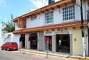 The town of Villa del Carbón lies near the center of the municipality at an altitude of 2,600 meters above sea level and has a population of 8,029 (2005 census). Most of the houses and other buildings in this town have white facades with pitched roofs covered in Spanish-style clay tile. The roads in the center of town are of cobblestone.
The main church of the town is called the Temple of Nuestra Señora de la Peña de Francia. It was constructed between 1700 and 1740 and is the origin of this particular community in the municipality. The church was originally constructed to house an image of the Virgin Mary called “La Virgen de la Peña de Francia,” which is one of only two brought to Mexico from Spain
. The other is in Salamanca, Guanajuato
. Those living around the church were not part of a named town, they were only known as “those who make charcoal.” People looking to locate this community were directed to the church of the community that made charcoal (and is the origin of the town’s name). This Virgin is black, like charcoal, and over time, many miracles became attributed to her. For this reason, this image was hidden by the local people for many years in fear that the authorities would take it from them. Today, however, she is plainly on display at the main altar. The church itself is a typical one for the early 18th century and reminiscent of Romantic style. In 1904, Crispín Montiel painted the cupola of the church with Biblical personages. The large trees on the church property date back to the founding of the municipality. To the side of the church is the Luisa Isabel Campos de Jiménez Cantú Municipal Park, which contains an open-air Greek-style theatre, surrounded by pine trees.
Across from the church is the main town plaza called Plaza Hidalgo, which was built and named in 1906 in preparation for the upcoming centennial of Mexico’s Independence. The kiosk in the center was the site of the town’s fountain, which used to provide potable water for the community. The kiosk contains the tourist information center for the municipality. The plaza was remodeled during town renovation work in the 1960s and 1970’s, which is when the current palms and giant eucalyptus trees were planted.
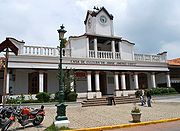 Aside from the church, the plaza is surrounded by the old and new municipal palaces, a number of residential structures with shops on the ground floors. The old municipal building site is now the Casa de Cultura Dr. Jorge Jiménez Cantú. The original municipal palace was built at the end of the 17th century and was of Neoclassical architecture
. By 1926, the old building had deteriorated enough to warrant demolition. A new, two-story building was constructed and inaugurated in 1931. This center contains the municipality library, an auditorium and a continuing education center.
Due to its traditional architecture and surrounding scenery, the town was included as one of the Pueblos con Encanto (Towns with Charm) program of the State of Mexico. The town has been actively seeking to take advantage of it, advertising itself as such and participating in the Pueblos con Encanto Bicentenario (Bicentennial Towns with Charm) program in preparation for Mexico Bicentennial of Independence in 2010.
To the north of this community is the Taxhimay Hacienda, which was owned by a major textile family from Tepeji del Río. In 1931, the Taxhimay Dam was built near here, which completely inundated the small village of San Luis de las Peras. This hacienda provided the space to the villages resettlement.
The oldest communities of this municipality are of Otomí or Nahua ethnicity. The Otomí arrived to this are first and their most representative villages are Taxhimay, Piequexhimó and San Lorenzo Pueblo Nuevo. The later Nahua villages are represented by Cachihuapan, San Luis Anáhuac, Temanacoya and Xajay. Both sets of communities retain many of their cultural roots. There is a story that when the communities of San Luis Taxhimay (Otomí) and San Luis Anáhuac (Nahua) were being “refounded” as Spanish colonial villages, there was a dispute between them as to who should become the custodian of which of two saint images: one of Saint Louis, King of France
and one of Our Lord of Lament. The story states that the dispute was finally settled by a coin toss, with the first image going to San Luis Anáhuac and the latter to San Luis Taxhimay.
The relatively abundant rains at the high elevations give rise to a large number of small fresh-water springs, which create small streams that eventually join into the municipality’s four rivers: the San Jeronimo, Las Animas, Los Sabios and El Oro. There is one other “river” called the “Río Seco” (Dry River) which flows only during the rainy season. Most of the bodies of water here have been created by the El Llano, Taxhimay, Benito Juárez and Molinitos Dams, with only one natural lake called Santa Catarina.
n world, as it was located where commercial traffic between Tula
and Teotihuacan
passed. This would lead to a number of fortifications and other structures. Remains of these can be found today such as the fortifications at Cañada and Taxhimay, the ceremonial mound at El Mogote and a highly deteriorated and overgrown set of buildings known as Iglesias Viejas (Old Churches). The oldest currently existing communities are still Otomí in character. This is because unlike their early neighbors, the Mazahua
s and the Matlatzinca
s, the Otomí favored areas with rugged terrain, so they dominated this area until about the 12th century. Later, Nahua people would come and settle in the area. By the 15th century, however, the Aztecs (a Nahua people) would dominate this area, making the Otomí a tributary people.
This would end with the Spanish Conquest of the Aztec Empire in the early 16th century. In the late 16th century, a number of Spanish families began renting lands from local chiefs here on which to raise cattle and sheep. These ranches would lead to more Spanish immigration to the area, who intermarried with the local population. During most of the colonial period, until 1714, the Chiapan area remained intact as an entity. In 1714, the area was split in what are now roughly the municipalities of Chapa de Mota and Villa del Carbón. At that time, however, the community which is now the municipal seat was only known by through its church as the “Congregation of Santa María de la Peña de Francia.” Later in the colonial period the community also became known as a major supplier of charcoal to surrounding communities such as San Pedro Atzcapotzaltongo, Magú, Cañada de Cisneros and even Mexico City. This activity gave it the moniker of “Villa Nueva del Carbón de nuestra Señora Santa María de la Peña de Francia” (New Village of Charcoal of Our Lady of Holy Mary of the Hill of France. It also gave rise to a number of legends. In order to identify the community, one would be directed to the Villa Nueva, en donde hacen carbon” (the New Village, where they make charcoal), which eventually led to the place being marked on maps simply as “El Carbón” and verbally, the phrase became contracted to Villa del Carbón.
When the Mexican War of Independence broke out in 1810, Villa del Carbon and the surrounding communities did not immediately join in with Miguel Hidalgo
’s cause. Support came after the nearby Battle of Monte de las Cruces
in 1810, which Hidalgo won. After that, many from here decided to join Hidalgo’s army. One notable participant from the municipal seat is José Manuel Correa, aka, José María Correa who fought with Pino, Arriaga, and Chito Villagrán and defeating the royalist commander Andrade en Venta Hermosa in 1811.
In the years immediately following Independence, this municipality suffered from the lack of political stability, which led to high crime rates, especially highway robbery. The rugged terrain here was ideal for these marauders to prey upon travelers and protect themselves from authorities. Finally in 1834, President Antonio López de Santa Anna
ordered Commander Francisco de Medina Troncoso y Ruizgómez to the region to combat the bandits, who had become extremely brazen. These forces fought with the bandits at their fortifications around Villa del Carbon, managing to overrun them in five days. In celebration, the bells of the church of Villa del Carbón rang out.
Another important event in the history of Villa del Carbón is the arrival of the captured Melchor Ocampo
in 1861 to be imprisoned at the Los Fresnos House. Later, he was transferred to Tepeji del Río, Hidalgo, where he was eventually executed. During the French Intervention
in 1863, Villa del Carbón sided with the Maximilian
, forming a regiment led by Colonel Patricio Garnada to fight for the emperor. The municipal seat was burned later in 1863 by Cuellar, including the priest’s house.
During the Mexican Revolution
, there is some evidence that the town had recurrent problems the Liberation Army of the South
, such as the severing of telegraph lines. During the Cristero War
, the town lost one of its leaders in 1928. In 1931, the town was electrified and was reached by its first highway, connecting the municipal seat to San Martín Cachihuapan. In this same year, the new municipal palace, zocalo and municipal park were built. The municipal palace’s clock was installed in 1943.
In the 1920s and 1930’s a number of ejidos such as San Lorenzo el Viejo, San Luis Anahua and Monte de Peña were created.
, hiking, rappelling, swimming, jet ski
ing, kayak
ing, canoe
ing, sailing and sport fishing, especially for trout. Accommodations here include tent and RV camping facilities and rustic cabins.
The largest and most important dam economically is the Taxhimay Dam. It was constructed in 1934, flooding the valley and covering the small community of San Luís de las Peras, leaving only the church tower and part of the cupola
visible above the water. Canoe tours to visit the tower and cupola are available. In addition to offering the activities listed above, it also hosts the annual XTERRA Triathlon
.
The El Llano Dam is 20 km from the town of Villa del Carbón and is located within a state park, which is also part of the Zacapexco ejido. The area has a relatively cold climate and the dam is surrounded by conifer forests. This area hosts the “Extremetour” event organized by Raid Mexico http://www.raidmexico.com/2009/separte.html. It also boasts a cabin large enough to accommodate twenty people.
Two smaller dams, the Benito Juárez and Molinitos are still primarily also offer many activities but on a smaller scale.
Trout has become an important economic resource. The large number of rivers and streams that feed into dams have created places to fish for trout as well as trout-farming. In locations like the Taxhimay Dam, boat rentals for fishing include cooking what you catch. Trout-farms raise and sell the fish to locales inside and outside of Villa del Carbón. There are also a number of restaurants dedicated to cuisine based on trout and other forest products. These restaurants are mostly located were rivers run near the highways to Mexico City and Atlacomulco
.
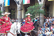 In and around the municipal seat, charreada is a major part of the local culture and competitions here have gone national. The main sponsor of these events is the Villa de Carbón Charreada Association, which has gained statues in the charreada world over the years. This association now hosts national-level competitions at the Lienzo Charro
Cornielio Nieto, located just outside the town of Villa del Carbón. One particular group of note is the Escaramuza Charra (a group of twelve women who perform choreographed equine displays). This group has placed in the top three in many regional and national-level competitions and placed fifth in the national championships of 2005. Villa del Carbón main charreada events take place on March 10 (founding of the municipality), September 16 (Mexican Independence
) and December 8 (Feast day of the patron saint of Villa del Carbón). On these days, the events are accompanies by musical events, dances, craft expositions and regional cuisine.
(temporary market) that pops up on weekends at Plaza Hidalgo in the town center. Lastly, the town also has a number of “rompope
” (a sweet egg liqueur) producers. Rompope was brought to Mexico by Spanish friars and its production here originated with the monasteries they established. Over time, however, its production fell into secular hands.
Mexico City
Mexico City is the Federal District , capital of Mexico and seat of the federal powers of the Mexican Union. It is a federal entity within Mexico which is not part of any one of the 31 Mexican states but belongs to the federation as a whole...
. While the town of Villa del Carbón is the largest in the municipality, it is not the oldest. The municipality contains a number of villages of Otomí
Otomi people
The Otomi people . Smaller Otomi populations exist in the states of Puebla, Mexico, Tlaxcala, Michoacán and Guanajuato. The Otomi language belonging to the Oto-Pamean branch of the Oto-Manguean language family is spoken in many different varieties some of which are not mutually intelligible.One of...
and Nahua origins, in which much of the indigenous culture still survives. The municipality’s territory was defined in 1714 when a region known as Chiapan, split into what is now Chapa de Mota
Chapa de Mota
Chapa de Mota is a village and municipality located in the northwest of Mexico State. It is located in the north part of the State of Mexico. It is 2 hours away from Mexico City.-The town:...
and Villa del Carbón. At that time, however, the community which is now a municipal seat did not have an official name; it was known first only by the name of its church Nuestra Señora de la Peña de Francia, and later by being a major supplier of charcoal. This would lead to the name of Villanueva del Carbón de Nuestra Señora Santa María de la Peña de Francia, which eventually shortened to Villa del Carbón. The major portions of the municipality’s glyph
Glyph
A glyph is an element of writing: an individual mark on a written medium that contributes to the meaning of what is written. A glyph is made up of one or more graphemes....
, which serves as it coat-of-arms, does not reflect the town of Villa del Carbón but rather two of its oldest communities: Taxhimay and San Lorenzo Pueblo Nuevo.
The municipality covers an area of 356.14 km2 and has a total population of 39,587 (2005 census). Of this total, 8,029 live in the municipal seat of Villa del Carbón and the rest live among the other 57 communities which rely on the seat for government purposes. The municipality border the municipalities of Jilotepec, Jiquipilco
Jiquipilco
Jiquipilco is a town and municipality located in State of Mexico in Mexico. It is north of the Valley of Toluca, part of the region consisting of the southern and western slopes of Cerro La Catedral, which has a concentration of speakers of the Otomi language. It is about 40 km from Toluca,...
, Tepotzotlán
Tepotzotlán
Tepotzotlán is a city and a municipality in the Mexico state of Mexico. It is located 115 km northeast of Mexico City about a 45-minute drive along the Mexico City-Querétaro at marker number 41. In Aztec times, the area was the center of a dominion that negotiated to keep most of its...
, Nicolas Romero, Chapa de Mota and Morelos
Morelos, Mexico
Morelos is a town and municipality in Mexico State in Mexico. The municipality covers an area of 222.76 km².As of 2005, the municipality had a total population of 26,430....
in Mexico State, with Tepejí del Río
Tepeji
Tepeji is a city and one of the 84 municipalities of Hidalgo, in central-eastern Mexico. The municipality covers an area of 393.4 km²....
, Hidalgo State bordering it to the north. The municipality is divided into three “barrios” or districts named Pendo, Centro, and Taxhihué.
Today, the municipality’s economy is based primarily on tourism, as it has a number of streams, rivers and dams suitable for water sports, trout
Trout
Trout is the name for a number of species of freshwater and saltwater fish belonging to the Salmoninae subfamily of the family Salmonidae. Salmon belong to the same family as trout. Most salmon species spend almost all their lives in salt water...
-fishing and camping facilities. It is also the home of a nationally recognized charreada
Charreada
The charreada or charrería is a competitive event similar to rodeo and was developed from animal husbandry practices used on the haciendas of Old Mexico. The sport has been described as "living history," or as an art form drawn the demands of working life...
(a type of rodeo
Rodeo
Rodeo is a competitive sport which arose out of the working practices of cattle herding in Spain, Mexico, and later the United States, Canada, South America and Australia. It was based on the skills required of the working vaqueros and later, cowboys, in what today is the western United States,...
) venue, that hosts major events.
The municipal seat
The main church of the town is called the Temple of Nuestra Señora de la Peña de Francia. It was constructed between 1700 and 1740 and is the origin of this particular community in the municipality. The church was originally constructed to house an image of the Virgin Mary called “La Virgen de la Peña de Francia,” which is one of only two brought to Mexico from Spain
Spain
Spain , officially the Kingdom of Spain languages]] under the European Charter for Regional or Minority Languages. In each of these, Spain's official name is as follows:;;;;;;), is a country and member state of the European Union located in southwestern Europe on the Iberian Peninsula...
. The other is in Salamanca, Guanajuato
Salamanca, Guanajuato
Salamanca is a city in the Mexican state of Guanajuato.Founded January 1, 1603 as 'Villa de Salamanca' by the Viceroy Gaspar de Zuniga and Acevedo, fifth Earl of Monterrey, who was originally from Salamanca...
. Those living around the church were not part of a named town, they were only known as “those who make charcoal.” People looking to locate this community were directed to the church of the community that made charcoal (and is the origin of the town’s name). This Virgin is black, like charcoal, and over time, many miracles became attributed to her. For this reason, this image was hidden by the local people for many years in fear that the authorities would take it from them. Today, however, she is plainly on display at the main altar. The church itself is a typical one for the early 18th century and reminiscent of Romantic style. In 1904, Crispín Montiel painted the cupola of the church with Biblical personages. The large trees on the church property date back to the founding of the municipality. To the side of the church is the Luisa Isabel Campos de Jiménez Cantú Municipal Park, which contains an open-air Greek-style theatre, surrounded by pine trees.
Across from the church is the main town plaza called Plaza Hidalgo, which was built and named in 1906 in preparation for the upcoming centennial of Mexico’s Independence. The kiosk in the center was the site of the town’s fountain, which used to provide potable water for the community. The kiosk contains the tourist information center for the municipality. The plaza was remodeled during town renovation work in the 1960s and 1970’s, which is when the current palms and giant eucalyptus trees were planted.
Neoclassical architecture
Neoclassical architecture was an architectural style produced by the neoclassical movement that began in the mid-18th century, manifested both in its details as a reaction against the Rococo style of naturalistic ornament, and in its architectural formulas as an outgrowth of some classicizing...
. By 1926, the old building had deteriorated enough to warrant demolition. A new, two-story building was constructed and inaugurated in 1931. This center contains the municipality library, an auditorium and a continuing education center.
Due to its traditional architecture and surrounding scenery, the town was included as one of the Pueblos con Encanto (Towns with Charm) program of the State of Mexico. The town has been actively seeking to take advantage of it, advertising itself as such and participating in the Pueblos con Encanto Bicentenario (Bicentennial Towns with Charm) program in preparation for Mexico Bicentennial of Independence in 2010.
Other communities in the municipality
While the town of Villa del Carbon is the largest community in the municipality, it is not the oldest. The oldest communities in the municipality are Cachihuapan, Taxhimay, Temanacoya y Zacapexco. Zacapexco is located to the southeast of the municipal seat and is old enough to be mentioned in the Huamantla Codex which was written in the 11th or 12th century as one of the Otomí groups to have left the cave in Chiapan to settle on the Zacatepexco Hill. The name Zacatepexco is from Nahuatl meaning “where there is a staw bed.” Another ancient community is the village of Taxhimay, located east of the municipal seat. Its name come from Otomí and means “pasture of white sheep,” as it is one of the few areas in the municipality with significant pasture land.To the north of this community is the Taxhimay Hacienda, which was owned by a major textile family from Tepeji del Río. In 1931, the Taxhimay Dam was built near here, which completely inundated the small village of San Luis de las Peras. This hacienda provided the space to the villages resettlement.
The oldest communities of this municipality are of Otomí or Nahua ethnicity. The Otomí arrived to this are first and their most representative villages are Taxhimay, Piequexhimó and San Lorenzo Pueblo Nuevo. The later Nahua villages are represented by Cachihuapan, San Luis Anáhuac, Temanacoya and Xajay. Both sets of communities retain many of their cultural roots. There is a story that when the communities of San Luis Taxhimay (Otomí) and San Luis Anáhuac (Nahua) were being “refounded” as Spanish colonial villages, there was a dispute between them as to who should become the custodian of which of two saint images: one of Saint Louis, King of France
Louis IX of France
Louis IX , commonly Saint Louis, was King of France from 1226 until his death. He was also styled Louis II, Count of Artois from 1226 to 1237. Born at Poissy, near Paris, he was an eighth-generation descendant of Hugh Capet, and thus a member of the House of Capet, and the son of Louis VIII and...
and one of Our Lord of Lament. The story states that the dispute was finally settled by a coin toss, with the first image going to San Luis Anáhuac and the latter to San Luis Taxhimay.
Geography and climate
The municipality of Villa del Carbón is located in the north of Mexico State, northwest of Mexico City. Much of the territory consists of rugged hills and mountains, with the high point being Cerro de la Bufa, at 3,600 meters above sea level. These hills and mountains join with the Sierra de Tepotzotlán to the east. These mountains here are known at the Sierra de Monte Alto. These mountains are covered in conifer forests and account for 58% of the municipality. Semi-arid rolling hills cover 34% and only about 9% is flat land, generally found in small isolated patches. The high attitude of between 2,300 and 3,600 meters gives the municipality a temperate climate, with freezing temperatures not uncommon in the winter. The highlands have a wet climate, while the lower hills can be semi-arid. Significant winds are present in much of the municipality.The relatively abundant rains at the high elevations give rise to a large number of small fresh-water springs, which create small streams that eventually join into the municipality’s four rivers: the San Jeronimo, Las Animas, Los Sabios and El Oro. There is one other “river” called the “Río Seco” (Dry River) which flows only during the rainy season. Most of the bodies of water here have been created by the El Llano, Taxhimay, Benito Juárez and Molinitos Dams, with only one natural lake called Santa Catarina.
History
Early human settlement in the Villa del Carbón area is demonstrated by cave paintings at a rock shelter located near the San Jeronimo River. The first known ethnicity to settle here are the Otomí, who called this area “Nñonthe” (top of the hill) Evidence of their early occupation is found in the way of primitive ceramic and human and animal figurines. These Otomí would be joined by other nomadic groups, who eventually synthesized their language and mythology. As they did so, this area became known as the Otomí region of Chiapan, which rough correlates with the modern-day municipalities of Villa del Carbón and Chapa de Mota. This region, along with neighboring Xillotepec (today Jilotepec) had significant influence in the early MesoamericaMesoamerica
Mesoamerica is a region and culture area in the Americas, extending approximately from central Mexico to Belize, Guatemala, El Salvador, Honduras, Nicaragua, and Costa Rica, within which a number of pre-Columbian societies flourished before the Spanish colonization of the Americas in the 15th and...
n world, as it was located where commercial traffic between Tula
Tula, Hidalgo
Tula, formally, Tula de Allende, is a town and one of the 84 municipalities of Hidalgo, in central-eastern Mexico. The municipality covers an area of 305.8 km² , and as of 2005, the municipality had a total population of 93,296, with 28,432 in the town...
and Teotihuacan
Teotihuacan
Teotihuacan – also written Teotihuacán, with a Spanish orthographic accent on the last syllable – is an enormous archaeological site in the Basin of Mexico, just 30 miles northeast of Mexico City, containing some of the largest pyramidal structures built in the pre-Columbian Americas...
passed. This would lead to a number of fortifications and other structures. Remains of these can be found today such as the fortifications at Cañada and Taxhimay, the ceremonial mound at El Mogote and a highly deteriorated and overgrown set of buildings known as Iglesias Viejas (Old Churches). The oldest currently existing communities are still Otomí in character. This is because unlike their early neighbors, the Mazahua
Mazahua
The Mazahua are an indigenous people of Mexico, inhabiting the northwestern portion of the State of Mexico and northeastern area of Michoacán, with a presence also in the Federal District owing to recent migration...
s and the Matlatzinca
Matlatzinca
Matlatzinca is a name used to refer to different indigenous ethnic groups in the Toluca Valley in the state of México, located in the central highlands of Mexico. The term is applied to the ethnic group inhabiting the valley of Toluca and to their language, Matlatzinca.When used as an ethnonym,...
s, the Otomí favored areas with rugged terrain, so they dominated this area until about the 12th century. Later, Nahua people would come and settle in the area. By the 15th century, however, the Aztecs (a Nahua people) would dominate this area, making the Otomí a tributary people.
This would end with the Spanish Conquest of the Aztec Empire in the early 16th century. In the late 16th century, a number of Spanish families began renting lands from local chiefs here on which to raise cattle and sheep. These ranches would lead to more Spanish immigration to the area, who intermarried with the local population. During most of the colonial period, until 1714, the Chiapan area remained intact as an entity. In 1714, the area was split in what are now roughly the municipalities of Chapa de Mota and Villa del Carbón. At that time, however, the community which is now the municipal seat was only known by through its church as the “Congregation of Santa María de la Peña de Francia.” Later in the colonial period the community also became known as a major supplier of charcoal to surrounding communities such as San Pedro Atzcapotzaltongo, Magú, Cañada de Cisneros and even Mexico City. This activity gave it the moniker of “Villa Nueva del Carbón de nuestra Señora Santa María de la Peña de Francia” (New Village of Charcoal of Our Lady of Holy Mary of the Hill of France. It also gave rise to a number of legends. In order to identify the community, one would be directed to the Villa Nueva, en donde hacen carbon” (the New Village, where they make charcoal), which eventually led to the place being marked on maps simply as “El Carbón” and verbally, the phrase became contracted to Villa del Carbón.
When the Mexican War of Independence broke out in 1810, Villa del Carbon and the surrounding communities did not immediately join in with Miguel Hidalgo
Miguel Hidalgo
Miguel Gregorio Antonio Ignacio Hidalgo y Costilla y Gallaga Mandarte Villaseñor , more commonly known as Miguel Hidalgo y Costilla or simply Miguel Hidalgo, was a Mexican priest and a leader of the Mexican War of Independence.In 1810 Hidalgo led a group of peasants in a revolt against the dominant...
’s cause. Support came after the nearby Battle of Monte de las Cruces
Battle of Monte de las Cruces
The Battle of Monte de las Cruces was one of the pivotal battles of the early Mexican War of Independence. It was fought between the insurgent troops of Miguel Hidalgo y Costilla and Ignacio Allende against the royalist troops of General Torcuato Trujillo in the Sierra de las Cruces mountains...
in 1810, which Hidalgo won. After that, many from here decided to join Hidalgo’s army. One notable participant from the municipal seat is José Manuel Correa, aka, José María Correa who fought with Pino, Arriaga, and Chito Villagrán and defeating the royalist commander Andrade en Venta Hermosa in 1811.
In the years immediately following Independence, this municipality suffered from the lack of political stability, which led to high crime rates, especially highway robbery. The rugged terrain here was ideal for these marauders to prey upon travelers and protect themselves from authorities. Finally in 1834, President Antonio López de Santa Anna
Antonio López de Santa Anna
Antonio de Padua María Severino López de Santa Anna y Pérez de Lebrón , often known as Santa Anna or López de Santa Anna, known as "the Napoleon of the West," was a Mexican political leader, general, and president who greatly influenced early Mexican and Spanish politics and government...
ordered Commander Francisco de Medina Troncoso y Ruizgómez to the region to combat the bandits, who had become extremely brazen. These forces fought with the bandits at their fortifications around Villa del Carbon, managing to overrun them in five days. In celebration, the bells of the church of Villa del Carbón rang out.
Another important event in the history of Villa del Carbón is the arrival of the captured Melchor Ocampo
Melchor Ocampo
Melchor Ocampo was a Mexican lawyer, scientist, and liberal politician.His home state was renamed Michoacán de Ocampo in his honour.-Studies:...
in 1861 to be imprisoned at the Los Fresnos House. Later, he was transferred to Tepeji del Río, Hidalgo, where he was eventually executed. During the French Intervention
French intervention in Mexico
The French intervention in Mexico , also known as The Maximilian Affair, War of the French Intervention, and The Franco-Mexican War, was an invasion of Mexico by an expeditionary force sent by the Second French Empire, supported in the beginning by the United Kingdom and the Kingdom of Spain...
in 1863, Villa del Carbón sided with the Maximilian
Maximilian I of Mexico
Maximilian I was the only monarch of the Second Mexican Empire.After a distinguished career in the Austrian Navy, he was proclaimed Emperor of Mexico on April 10, 1864, with the backing of Napoleon III of France and a group of Mexican monarchists who sought to revive the Mexican monarchy...
, forming a regiment led by Colonel Patricio Garnada to fight for the emperor. The municipal seat was burned later in 1863 by Cuellar, including the priest’s house.
During the Mexican Revolution
Mexican Revolution
The Mexican Revolution was a major armed struggle that started in 1910, with an uprising led by Francisco I. Madero against longtime autocrat Porfirio Díaz. The Revolution was characterized by several socialist, liberal, anarchist, populist, and agrarianist movements. Over time the Revolution...
, there is some evidence that the town had recurrent problems the Liberation Army of the South
Liberation Army of the South
The Liberation Army of the South was an armed group formed and led by Emiliano Zapata that took part in the Mexican Revolution. The force was commonly known as the Zapatistas....
, such as the severing of telegraph lines. During the Cristero War
Cristero War
The Cristero War of 1926 to 1929 was an uprising and counter-revolution against the Mexican government in power at that time. The rebellion was set off by the strict enforcement of the anti-clerical provisions of the Mexican Constitution of 1917 and the expansion of further anti-clerical laws...
, the town lost one of its leaders in 1928. In 1931, the town was electrified and was reached by its first highway, connecting the municipal seat to San Martín Cachihuapan. In this same year, the new municipal palace, zocalo and municipal park were built. The municipal palace’s clock was installed in 1943.
In the 1920s and 1930’s a number of ejidos such as San Lorenzo el Viejo, San Luis Anahua and Monte de Peña were created.
Tourism
Tourism is the major source of income for the municipality, based on its natural resources. The various small streams fed by fresh-water springs converge into four rivers in the territory. These rivers were dammed in the first half of the 20th century, originally for agricultural purposes but they have become an important source of tourism, including ecotourism revenue. There are four main dams that attract tourists: Taxhimay, El Llano, Molinitos and Benito Juárez. These dams offer a number of activities, such as mountain bikingMountain biking
Mountain biking is a sport which consists of riding bicycles off-road, often over rough terrain, using specially adapted mountain bikes. Mountain bikes share similarities with other bikes, but incorporate features designed to enhance durability and performance in rough terrain.Mountain biking can...
, hiking, rappelling, swimming, jet ski
Jet ski
Jet Ski is the brand name of a personal watercraft manufactured by Kawasaki Heavy Industries. The name is sometimes mistakenly used by those unfamiliar with the personal watercraft industry to refer to any type of personal watercraft; however, the name is a valid trademark registered with the...
ing, kayak
Kayak
A kayak is a small, relatively narrow, human-powered boat primarily designed to be manually propelled by means of a double blade paddle.The traditional kayak has a covered deck and one or more cockpits, each seating one paddler...
ing, canoe
Canoe
A canoe or Canadian canoe is a small narrow boat, typically human-powered, though it may also be powered by sails or small electric or gas motors. Canoes are usually pointed at both bow and stern and are normally open on top, but can be decked over A canoe (North American English) or Canadian...
ing, sailing and sport fishing, especially for trout. Accommodations here include tent and RV camping facilities and rustic cabins.
The largest and most important dam economically is the Taxhimay Dam. It was constructed in 1934, flooding the valley and covering the small community of San Luís de las Peras, leaving only the church tower and part of the cupola
Cupola
In architecture, a cupola is a small, most-often dome-like, structure on top of a building. Often used to provide a lookout or to admit light and air, it usually crowns a larger roof or dome....
visible above the water. Canoe tours to visit the tower and cupola are available. In addition to offering the activities listed above, it also hosts the annual XTERRA Triathlon
XTERRA Triathlon
XTERRA is a series of off-road triathlon races, . The XTERRA Global Tour is owned and produced by...
.
The El Llano Dam is 20 km from the town of Villa del Carbón and is located within a state park, which is also part of the Zacapexco ejido. The area has a relatively cold climate and the dam is surrounded by conifer forests. This area hosts the “Extremetour” event organized by Raid Mexico http://www.raidmexico.com/2009/separte.html. It also boasts a cabin large enough to accommodate twenty people.
Two smaller dams, the Benito Juárez and Molinitos are still primarily also offer many activities but on a smaller scale.
Trout has become an important economic resource. The large number of rivers and streams that feed into dams have created places to fish for trout as well as trout-farming. In locations like the Taxhimay Dam, boat rentals for fishing include cooking what you catch. Trout-farms raise and sell the fish to locales inside and outside of Villa del Carbón. There are also a number of restaurants dedicated to cuisine based on trout and other forest products. These restaurants are mostly located were rivers run near the highways to Mexico City and Atlacomulco
Atlacomulco
Atlacomulco is a city and municipality located in the northwest of the State of Mexico in central Mexico, 63 km from the state capital of Toluca. The name is derived from the Nahuatl phrase "atlacomulli" which means "where there are wells." The city, with a population of 20,477 is...
.
Lienzo charro
A lienzo charro is an arena where charros hold the events of charreada, torneo de colas and bull riding. A lienzo has two areas: one and a second, circular area in diameter. Charreada is a team competition in which teams go head-to-head to win points in different competitions. The team with the...
Cornielio Nieto, located just outside the town of Villa del Carbón. One particular group of note is the Escaramuza Charra (a group of twelve women who perform choreographed equine displays). This group has placed in the top three in many regional and national-level competitions and placed fifth in the national championships of 2005. Villa del Carbón main charreada events take place on March 10 (founding of the municipality), September 16 (Mexican Independence
Grito de Dolores
The Grito de Dolores also known as El Grito de la Independencia , uttered from the small town of Dolores, near Guanajuato on April 19, 1810 is the event that marks the beginning of the Mexican War of Independence and is the most important national holiday observed in Mexico...
) and December 8 (Feast day of the patron saint of Villa del Carbón). On these days, the events are accompanies by musical events, dances, craft expositions and regional cuisine.
Handcrafts
With ranches and charreadas an important part of Villa de Carbón’s history and culture, crafts related to these, especially leather-making and leather products. Principal goods made are boots, leather jackets, hats and other items related to the needs of horsemen. Crafts-production employs significant percentage of the municipality’s residents. The most important item produced here is called “botines,” which is a kind of ankle-high boot associated with charreada. Villa del Carbón is one of the last locations in Mexico to be a significant producer of this footwear and they are exported to many locations in the country. Another craft practiced here is the making of knit items such as scarves, ponchos, wraps, sweaters,etc. These are mostly available at the tianguisTianguis
A tianguis is an open air market or bazaar that is traditionally held on certain market days in a town or city neighborhood in Mexico and Central America. This bazaar tradition has its roots well into the pre-Hispanic period and continues in many cases essentially unchanged into the present day....
(temporary market) that pops up on weekends at Plaza Hidalgo in the town center. Lastly, the town also has a number of “rompope
Rompope
Rompope is an eggnog-like drink made with eggs, milk, and vanilla flavouring. The egg yolks impart a yellow hue to the emulsified beverage. It is a traditional drink in Mexico, where it was originally made in the convents of the city of Puebla. The word rompope is a derivation of the word rompon,...
” (a sweet egg liqueur) producers. Rompope was brought to Mexico by Spanish friars and its production here originated with the monasteries they established. Over time, however, its production fell into secular hands.