
Washington State Route 240
Encyclopedia
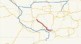
State Route 240 is a busy state highway
servicing the Tri-Cities of Washington and the Hanford Site
.
in central Kennewick as an offshoot of U.S. Route 395. It continues as a freeway through northern Kennewick just south of the Columbia River
—passing near the Columbia Center Mall
on the way—all the way up to Richland
, where it effectively enters into town as the heavily-traveled George Washington Way at the interchange with Interstate 182. However, it is possible to continue on the highway (though it is no longer a freeway after the Interstate 182 interchange) by taking an exit and traveling around the west side of town—the highway is known for that stretch of land as the "Bypass Highway". This name, given when the highway actually avoided most of the rush-hour gridlock and constant stoplights of George Washington Way, is somewhat ironic nowadays as the six stoplights on this section of the highway impede drivers just as the traffic-laden main street has for decades.
In any case, after traveling north for roughly five miles, the road itself continues northward as Stevens Drive, but the highway itself goes on as an offshoot, this time heading to the northwest. The highway enters the Hanford Nuclear Reservation and goes on for dozens of miles. Eventually, it ends in State Route 24. Going north onto Highway 24 leads to Interstate 90 and George, Washington
; going west instead leads to Yakima, Washington
.
SR 240 has a bike path that runs adjacent to it from Columbia Park Trail, where it continues east along the Columbia River, to Stevens Drive, where it continues north to Hanford.
was built, SR 240 was known as US 12 from Columbia Park Trail to its junction with today's US 395 where US 12 continued across the Blue Bridge to Pasco
. Even before this, the same portion was known as US 410
before US 12 was expanded from Lewiston
to Aberdeen
in 1967. Before the freeway was built in on the north side of Kennewick, US 410 and later US 12 followed Columbia Park Trail to the Green Bridge east of Downtown Kennewick (today's SR 397
).
Due to the heavy traffic pressed upon the highway during rush hour, the road underwent significant construction
from the Columbia Center Boulevard exit in Kennewick all the way up through the first mile or so of George Washington Way. This included demolition of the fifty year-old four-lane bridge that spanned the Yakima River
, where in its place two four-lane bridges were constructed. A more controversial change came at the eastbound exit to Columbia Park Trail, where a two-lane roundabout
intersection - which connects the exit, Columbia Park Trail and Steptoe Avenue - was constructed. The work was completed in early June of 2007, several months ahead of schedule.
State highway
State highway, state road or state route can refer to one of three related concepts, two of them related to a state or provincial government in a country that is divided into states or provinces :#A...
servicing the Tri-Cities of Washington and the Hanford Site
Hanford Site
The Hanford Site is a mostly decommissioned nuclear production complex on the Columbia River in the U.S. state of Washington, operated by the United States federal government. The site has been known by many names, including Hanford Works, Hanford Engineer Works or HEW, Hanford Nuclear Reservation...
.
Route description
Its eastern end begins at the southern end of the Blue BridgeBlue Bridge (Washington)
The Blue Bridge is a four-lane arch-truss bridge connecting Pasco, Washington to Kennewick, Washington. U.S. Route 395 crosses the Columbia River via this bridge. The name comes from the blue paint used on the truss superstructure, with white paint on the suspension beams...
in central Kennewick as an offshoot of U.S. Route 395. It continues as a freeway through northern Kennewick just south of the Columbia River
Columbia River
The Columbia River is the largest river in the Pacific Northwest region of North America. The river rises in the Rocky Mountains of British Columbia, Canada, flows northwest and then south into the U.S. state of Washington, then turns west to form most of the border between Washington and the state...
—passing near the Columbia Center Mall
Columbia Center Mall
Columbia Center Mall is a shopping mall located in northwestern Kennewick, Washington, owned by Simon Property Group. It is the largest mall in southeastern Washington, and regularly draws visitors from as far away as La Grande, Oregon.-History:...
on the way—all the way up to Richland
Richland, Washington
Richland is a city in Benton County in the southeastern part of the U.S. state of Washington, at the confluence of the Yakima and the Columbia Rivers. As of the 2010 census, the city population was 48,058. April 1, 2011 estimates from the Washington State Office of Financial Management put the...
, where it effectively enters into town as the heavily-traveled George Washington Way at the interchange with Interstate 182. However, it is possible to continue on the highway (though it is no longer a freeway after the Interstate 182 interchange) by taking an exit and traveling around the west side of town—the highway is known for that stretch of land as the "Bypass Highway". This name, given when the highway actually avoided most of the rush-hour gridlock and constant stoplights of George Washington Way, is somewhat ironic nowadays as the six stoplights on this section of the highway impede drivers just as the traffic-laden main street has for decades.
In any case, after traveling north for roughly five miles, the road itself continues northward as Stevens Drive, but the highway itself goes on as an offshoot, this time heading to the northwest. The highway enters the Hanford Nuclear Reservation and goes on for dozens of miles. Eventually, it ends in State Route 24. Going north onto Highway 24 leads to Interstate 90 and George, Washington
George, Washington
George is a city in Grant County, Washington, United States. The population was 528 at the 2000 census. Its name is a play on the name of George Washington.The city is known for being near the Gorge Amphitheatre, sometimes being called, "The Gorge at George"....
; going west instead leads to Yakima, Washington
Yakima, Washington
Yakima is an American city southeast of Mount Rainier National Park and the county seat of Yakima County, Washington, United States, and the eighth largest city by population in the state itself. As of the 2010 census, the city had a total population of 91,196 and a metropolitan population of...
.
SR 240 has a bike path that runs adjacent to it from Columbia Park Trail, where it continues east along the Columbia River, to Stevens Drive, where it continues north to Hanford.
History
Before Interstate 182Interstate 182
Interstate 182 is a Interstate Highway that extends from I-82 west of Richland to US 12 in Pasco. It serves the Tri-Cities. The whole length of I-182 is concurrent with US 12, which extends westwards to Yakima, Naches, and Aberdeen and extends eastwards to Walla Walla, Lewiston, Idaho,...
was built, SR 240 was known as US 12 from Columbia Park Trail to its junction with today's US 395 where US 12 continued across the Blue Bridge to Pasco
Pasco, Washington
Pasco is a city in and the county seat of Franklin County, Washington, United States.Pasco is one of three cities that make up the Tri-Cities region of the state of Washington...
. Even before this, the same portion was known as US 410
U.S. Route 410
U.S. Route 410 was one of the west–east state highways. It ran from an intersection with US 101 in Aberdeen, Washington to US 95 in Lewiston, Idaho. The route had concurrencies with SR 8, US 99, and US 395. Even though the number indicates that US 410 was a spur of U.S. Route 10, US 410 never...
before US 12 was expanded from Lewiston
Lewiston, Idaho
Lewiston is a city in and also the county seat of Nez Perce County in the Pacific Northwest state of Idaho. It is the second-largest city in the northern Idaho region, behind Coeur d'Alene and ninth-largest in the state. Lewiston is the principal city of the Lewiston, ID - Clarkston, WA...
to Aberdeen
Aberdeen, Washington
Aberdeen is a city in Grays Harbor County, Washington, United States, founded by Samuel Benn in 1884. Aberdeen was incorporated on May 12, 1890. The city is the economic center of Grays Harbor County, bordering the cities of Hoquiam and Cosmopolis...
in 1967. Before the freeway was built in on the north side of Kennewick, US 410 and later US 12 followed Columbia Park Trail to the Green Bridge east of Downtown Kennewick (today's SR 397
Washington State Route 397
State Route 397 is a state highway in Benton and Frankin counties, in the U.S. state of Washington. It extends from Piert Road in Finley, north on the Cable Bridge over the Columbia River, to Interstate 182 , U.S. Route 12 , and US 395 in Pasco. The route serves as a connector between...
).
Due to the heavy traffic pressed upon the highway during rush hour, the road underwent significant construction
Construction
In the fields of architecture and civil engineering, construction is a process that consists of the building or assembling of infrastructure. Far from being a single activity, large scale construction is a feat of human multitasking...
from the Columbia Center Boulevard exit in Kennewick all the way up through the first mile or so of George Washington Way. This included demolition of the fifty year-old four-lane bridge that spanned the Yakima River
Yakima River
The Yakima River is a tributary of the Columbia River in south central and eastern Washington State, named for the indigenous Yakama people. The length of the river from headwaters to mouth is , with an average drop of .-Course:...
, where in its place two four-lane bridges were constructed. A more controversial change came at the eastbound exit to Columbia Park Trail, where a two-lane roundabout
Roundabout
A roundabout is the name for a road junction in which traffic moves in one direction around a central island. The word dates from the early 20th century. Roundabouts are common in many countries around the world...
intersection - which connects the exit, Columbia Park Trail and Steptoe Avenue - was constructed. The work was completed in early June of 2007, several months ahead of schedule.
Major intersections
The entire route is in Benton County.| Location | Mile | Destinations | Notes |
|---|---|---|---|
| 0.00 | |||
| 20.48 | |||
| Richland | 28.86 | Stevens Drive – Hanford, Richland | Former SR 240 east |
| 29.66 | Richland Airport Richland Airport (Washington) Richland Airport is a public airport located two miles northwest of the central business district of Richland, a city in Benton County, Washington, United States... |
||
| 30.25 | |||
| 32.99 | Aaron Drive, Lawless Drive, Thayer Drive, Wellsian Way | Interchange westbound; at-grade intersection At-grade intersection An at-grade intersection is a junction at which two or more transport axes cross at the same level .-Traffic management:With areas of high or fast traffic, an at-grade intersection normally requires a traffic control device such as a stop sign, traffic light or railway signal to manage conflicting... eastbound |
|
| West end of freeway | |||
| 33.10 | , Pendleton | West end of I-182/US 12 overlap | |
| 34.22 | East end of I-182/US 12 overlap | ||
| 34.22 | George Washington Way | Former SR 240 west | |
| 35.91 | Columbia Park Trail | Former US 12 west | |
| 37.07 | Columbia Center Boulevard | ||
| Kennewick | 38.65 | Edison Street | |
| 40.74 | Columbia Park Columbia Park For other places known as Columbia Park, see Columbia Park Columbia Park or Columbia Avenue Grounds was a baseball stadium that formerly stood in Philadelphia, Pennsylvania... Trail |
Westbound exit and entrance only | |
| 41.34 | , Umatilla | Continuation on US 395 | |
| 41.34 | Columbia Drive | ||