
Washington State Route 26
Encyclopedia
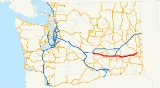
State Route 26 is a state highway in the Grant, Adams, and Whitman
counties, in the U.S. state of Washington. It extends 133.61 miles (215.02 km) from Interstate 90
(I-90) east of the community of Vantage
, east to U.S. Route 195
(US 195) in Colfax
. SR 26 intersects SR 24, SR 17, US 395
, and SR 261
before ending in Colfax. The route serves as a connector between Vantage, Royal City
, Othello
, Washtucna
, La Crosse
, and Colfax.
SR 26 has its own spur route
located in Colfax. SR 26 from Vantage to Washtucna was Secondary State Highway 7C (SSH 7C) from an unknown date until 1964, Washtucna to Dusty
was SSH 11B, and from Dusty to US 195 in Colfax was US 295 from 1926 until 1967, when US 295 was removed from the system. That portion of SR 26 had also been part of State Road 3 from 1923 until 1937, when State Road 3 was replaced by Primary State Highway 3 (PSH 3). PSH 3 existed until 1964, when a highway renumbering occurred, which created SR 26.
, east to US 195 in Colfax
. The route links Vantage, Royal City
, Othello
, Washtucna
, La Crosse
, and Colfax, and intersects four highways: SR 24, SR 17, US 395, and SR 261 before ending at US 195. WSDOT has found that about 5,400 motorists utilize the road daily at the intersection with First Street in Othello based on average annual daily traffic (AADT) data.
SR 26 starts at I-90 east of Vantage, about 0.36 mile (0.5793624 km) east of the Vantage Bridge
, where I-90 travels over the Columbia River
, and the highway starts at the opposite side of the river from Ginkgo/Wanapum State Park
. From the interchange, SR 26 runs south to intersect SR 243
and then the highway turns east past Royal City
and intersects SR 262
before entering the Columbia National Wildlife Refuge
and leaving Grant County to enter Adams County.
After entering Adams County, SR 26 leaves the Columbia National Wildlife Refuge
and goes east to Othello
and intersects SR 24 and SR 17. From Othello, the road continues east to Hatton
and intersects US 395
and SR 21. From the intersections, the highway goes eastward to Washtucna
, where it intersects SR 261
/SR 260
and dips to its southernmost point, about 4.3 miles (6.9 km) east of Washtucna, and then passes Hooper
. The road then exits Adams County and enters Whitman County
.
After entering Whitman County, SR 26 goes northeast towards La Crosse
and the La Crosse Airport and then slightly turns east to Dusty
. In Dusty, the road intersects the northern end of SR 127
, former US 295 and then goes east and then northeast to Colfax
and ends at US 195
.
, east to US 195 in Colfax
. The route goes from SR 26, then crosses the Palouse River
onto southbound US 195. WSDOT has found that 3,200 motorists utilize the road daily.
 SR 26 became a state highway during the 1964 highway renumbering, in which the Washington State Department of Transportation
(WSDOT) replaced the previous system of Primary and Secondary Highways with a new system called State Routes
, which is still in use today. Before the Primary and Secondary system, SR 26 in 1923 was part of State Road 3, which later became U.S. Route 295 (US 295) in 1926. Later, in 1937, the route became parts of Secondary State Highway 11B (SSH 11B) from US 395
, then known also as PSH 11, to PSH 3 / US 295 in Dusty
, PSH 3 from Dusty to Colfax
. SSH 7C from I-90
, then known as PSH 7 and US 10, to US 395, then known also as PSH 11, was added at an unknown time. Those highways became SR 26 in 1964, and US 295 was later removed from the system of highways in 1967.
A couple of recent and current construction projects are occurring along SR 26. One of which, involves illuminating the highway's intersection with B SE, which was finished in 2008, and Reynolds Road, to be done in 2009, west and east of Othello
, respectively. Another project added a left turn lane at a dangerous intersection between SR 26 and South Thacker Road west of Othello. The most major of the recent projects include the addition and demolition of ramps at the I-90
interchange. Another minor project, a bridge fixing project, was completed in 2007, located northeast of Dusty and southwest of Colfax
.
Whitman County, Washington
Whitman County is a county located in the U.S. state of Washington. As of the 2010 census, the population was 44,776, with the majority living in its largest city, Pullman, home to Washington State University, the state's land-grant university. The county seat is at Colfax.Whitman County was...
counties, in the U.S. state of Washington. It extends 133.61 miles (215.02 km) from Interstate 90
Interstate 90 in Washington
Interstate 90 , a transcontinental Interstate Highway from Seattle, Washington, to Boston, Massachusetts, crosses the state of Washington before crossing the Idaho state line between Spokane and Post Falls...
(I-90) east of the community of Vantage
Vantage, Washington
Vantage is a census-designated place in Kittitas County, Washington, United States. The population was 70 at the 2000 census.-History:The area around Vantage has been occupied by the Wanapum Native Americans since prehistory. A number of well-preserved rock-paintings have been found on the cliff...
, east to U.S. Route 195
U.S. Route 195
U.S. Route 195 is a north–south U.S. Route serving the southeastern area of Washington. One of the oldest designations in the U.S. Highway system, it was created in the original 1926 plan. The highway passes two major universities, Washington State University in Pullman, and the University...
(US 195) in Colfax
Colfax, Washington
Colfax is the county seat of Whitman County, Washington, United States.The population was 2,805 at the 2010 census.It is situated amidst wheat-covered hills in a valley at the confluence of the north and south forks of the Palouse River. U.S...
. SR 26 intersects SR 24, SR 17, US 395
U.S. Route 395 in Washington
In the U.S. state of Washington, U.S. Route 395 is a major state highway in two parts, separated by a long overlap with Interstate 90 between Ritzville and Spokane. The southern piece, from I-82 near the Tri-Cities to I-90 near Ritzville, is a high-speed four-lane divided highway...
, and SR 261
Washington State Route 261
State Route 261 is a state route in the U.S. state of Washington.-Route description:Route 261 begins at U.S. Route 12 near Starbuck. After this, it passes through Starbuck. It travels northwest, passing by Lyons Ferry Park. It then intersects State Route 260 southeast of Washtucna...
before ending in Colfax. The route serves as a connector between Vantage, Royal City
Royal City, Washington
Royal City is a city in Grant County, Washington, United States. The population was 1,823 at the 2000 census.-History:Royal City was founded in 1956 and officially incorporated on February 14, 1962. The townsite was previously named Royal Flats, and the entire area Royal Slope, thus the name Royal...
, Othello
Othello, Washington
Othello is a city in Adams County, Washington, United States. The population was 5,847 at the 2000 census and grew 25.9% over the next decade to 7,364 at the 2010 census. Othello refers to the city as being in the "Heart" of the Columbia Basin Project...
, Washtucna
Washtucna, Washington
Washtucna is a town in Adams County, Washington, United States. The population was 208 at the 2010 census, a 20% decrease over the previous census...
, La Crosse
La Crosse, Washington
La Crosse is a town in Whitman County, Washington, United States. The population was 313 at the 2010 census.-History:LaCrosse was incorporated on February 19, 1917....
, and Colfax.
SR 26 has its own spur route
Spur route
A spur route is a short road forming a branch from a longer, more important route . A bypass or beltway is never considered a true spur route as it typically reconnects with the major road...
located in Colfax. SR 26 from Vantage to Washtucna was Secondary State Highway 7C (SSH 7C) from an unknown date until 1964, Washtucna to Dusty
Dusty, Washington
Dusty is an unincorporated community in Whitman County, Washington, United States. It lies on Secondary State Highway 11A.-Geography:The community is located in the Palouse Region, which is known for its rolling hills and agricultural production...
was SSH 11B, and from Dusty to US 195 in Colfax was US 295 from 1926 until 1967, when US 295 was removed from the system. That portion of SR 26 had also been part of State Road 3 from 1923 until 1937, when State Road 3 was replaced by Primary State Highway 3 (PSH 3). PSH 3 existed until 1964, when a highway renumbering occurred, which created SR 26.
Route description
SR 26 runs 133.61 miles (215.02 km) from I-90 east of VantageVantage, Washington
Vantage is a census-designated place in Kittitas County, Washington, United States. The population was 70 at the 2000 census.-History:The area around Vantage has been occupied by the Wanapum Native Americans since prehistory. A number of well-preserved rock-paintings have been found on the cliff...
, east to US 195 in Colfax
Colfax, Washington
Colfax is the county seat of Whitman County, Washington, United States.The population was 2,805 at the 2010 census.It is situated amidst wheat-covered hills in a valley at the confluence of the north and south forks of the Palouse River. U.S...
. The route links Vantage, Royal City
Royal City, Washington
Royal City is a city in Grant County, Washington, United States. The population was 1,823 at the 2000 census.-History:Royal City was founded in 1956 and officially incorporated on February 14, 1962. The townsite was previously named Royal Flats, and the entire area Royal Slope, thus the name Royal...
, Othello
Othello, Washington
Othello is a city in Adams County, Washington, United States. The population was 5,847 at the 2000 census and grew 25.9% over the next decade to 7,364 at the 2010 census. Othello refers to the city as being in the "Heart" of the Columbia Basin Project...
, Washtucna
Washtucna, Washington
Washtucna is a town in Adams County, Washington, United States. The population was 208 at the 2010 census, a 20% decrease over the previous census...
, La Crosse
La Crosse, Washington
La Crosse is a town in Whitman County, Washington, United States. The population was 313 at the 2010 census.-History:LaCrosse was incorporated on February 19, 1917....
, and Colfax, and intersects four highways: SR 24, SR 17, US 395, and SR 261 before ending at US 195. WSDOT has found that about 5,400 motorists utilize the road daily at the intersection with First Street in Othello based on average annual daily traffic (AADT) data.
SR 26 starts at I-90 east of Vantage, about 0.36 mile (0.5793624 km) east of the Vantage Bridge
Vantage Bridge
The Vantage Bridge is a bridge in the U.S. state of Washington. It carries Interstate 90 across the Columbia River, near Vantage and George, Washington. This section of the river is named Wanapum Lake; it is the reservoir formed by Wanapum Dam...
, where I-90 travels over the Columbia River
Columbia River
The Columbia River is the largest river in the Pacific Northwest region of North America. The river rises in the Rocky Mountains of British Columbia, Canada, flows northwest and then south into the U.S. state of Washington, then turns west to form most of the border between Washington and the state...
, and the highway starts at the opposite side of the river from Ginkgo/Wanapum State Park
Ginkgo/Wanapum State Park
Ginkgo Petrified Forest State Park/Wanapum Recreational Area is a state park at Vantage, Washington including 27,000 feet of freshwater shoreline on the Wanapum Reservoir on the Columbia River. Petrified wood was discovered in the region in the early 1930s, which led to creation of the park...
. From the interchange, SR 26 runs south to intersect SR 243
Washington State Route 243
State Route 243 is a long state highway in the U.S. state of Washington, located entirely within Grant County and serving Desert Aire, Mattawa, Beverly and Vantage. The roadway, which roughly parallels the Columbia River, begins at southwest of Desert Aire and continues north past the...
and then the highway turns east past Royal City
Royal City, Washington
Royal City is a city in Grant County, Washington, United States. The population was 1,823 at the 2000 census.-History:Royal City was founded in 1956 and officially incorporated on February 14, 1962. The townsite was previously named Royal Flats, and the entire area Royal Slope, thus the name Royal...
and intersects SR 262
Washington State Route 262
State Route 262 is a state route in the U.S. state of Washington.-Route description:Route 262 begins at State Route 26 northwest of Othello. It travels north for a few miles before turning east and passing by Potholes State Park. After this, it passes just south of Potholes Reservoir, crossing the...
before entering the Columbia National Wildlife Refuge
Columbia National Wildlife Refuge
Columbia National Wildlife Refuge is a scenic mixture of rugged cliffs, canyons, lakes, and sagebrush grasslands. Formed by fire, ice, floods, and volcanic tempest, carved by periods of extreme violence of natural forces, the refuge lies in the middle of the Drumheller Channeled Scablands of...
and leaving Grant County to enter Adams County.
After entering Adams County, SR 26 leaves the Columbia National Wildlife Refuge
Columbia National Wildlife Refuge
Columbia National Wildlife Refuge is a scenic mixture of rugged cliffs, canyons, lakes, and sagebrush grasslands. Formed by fire, ice, floods, and volcanic tempest, carved by periods of extreme violence of natural forces, the refuge lies in the middle of the Drumheller Channeled Scablands of...
and goes east to Othello
Othello, Washington
Othello is a city in Adams County, Washington, United States. The population was 5,847 at the 2000 census and grew 25.9% over the next decade to 7,364 at the 2010 census. Othello refers to the city as being in the "Heart" of the Columbia Basin Project...
and intersects SR 24 and SR 17. From Othello, the road continues east to Hatton
Hatton, Washington
Hatton is a small incorporated town in Adams County, Washington, United States. The population was 98 at the 2000 census and 101 at the 2010 census.-History:...
and intersects US 395
U.S. Route 395 in Washington
In the U.S. state of Washington, U.S. Route 395 is a major state highway in two parts, separated by a long overlap with Interstate 90 between Ritzville and Spokane. The southern piece, from I-82 near the Tri-Cities to I-90 near Ritzville, is a high-speed four-lane divided highway...
and SR 21. From the intersections, the highway goes eastward to Washtucna
Washtucna, Washington
Washtucna is a town in Adams County, Washington, United States. The population was 208 at the 2010 census, a 20% decrease over the previous census...
, where it intersects SR 261
Washington State Route 261
State Route 261 is a state route in the U.S. state of Washington.-Route description:Route 261 begins at U.S. Route 12 near Starbuck. After this, it passes through Starbuck. It travels northwest, passing by Lyons Ferry Park. It then intersects State Route 260 southeast of Washtucna...
/SR 260
Washington State Route 260
State Route 260 is a state route in the U.S. state of Washington.-Route description:Route 260 begins at State Route 17 northeast of Connell. It travels east and intersects with U.S. Route 395. It also intersects with State Route 21 and State Route 263 in Kahlotus. The terminus is then at State...
and dips to its southernmost point, about 4.3 miles (6.9 km) east of Washtucna, and then passes Hooper
Hooper, Washington
Hooper is an unincorporated community in Whitman County, Washington, United States.-History:Hooper was named around 1883 for early settler Albert J. Hooper....
. The road then exits Adams County and enters Whitman County
Whitman County, Washington
Whitman County is a county located in the U.S. state of Washington. As of the 2010 census, the population was 44,776, with the majority living in its largest city, Pullman, home to Washington State University, the state's land-grant university. The county seat is at Colfax.Whitman County was...
.
After entering Whitman County, SR 26 goes northeast towards La Crosse
La Crosse, Washington
La Crosse is a town in Whitman County, Washington, United States. The population was 313 at the 2010 census.-History:LaCrosse was incorporated on February 19, 1917....
and the La Crosse Airport and then slightly turns east to Dusty
Dusty, Washington
Dusty is an unincorporated community in Whitman County, Washington, United States. It lies on Secondary State Highway 11A.-Geography:The community is located in the Palouse Region, which is known for its rolling hills and agricultural production...
. In Dusty, the road intersects the northern end of SR 127
Washington State Route 127
State Route 127 is a state highway in the U.S. state of Washington, running from U.S. Route 12 near Pomeroy north to a junction with State Route 26 near Lacrosse.- Route description :...
, former US 295 and then goes east and then northeast to Colfax
Colfax, Washington
Colfax is the county seat of Whitman County, Washington, United States.The population was 2,805 at the 2010 census.It is situated amidst wheat-covered hills in a valley at the confluence of the north and south forks of the Palouse River. U.S...
and ends at US 195
U.S. Route 195
U.S. Route 195 is a north–south U.S. Route serving the southeastern area of Washington. One of the oldest designations in the U.S. Highway system, it was created in the original 1926 plan. The highway passes two major universities, Washington State University in Pullman, and the University...
.
SR 26 Spur
SR 26 Spur runs 0.07 mile (0.1126538 km) from SR 26 west of ColfaxColfax, Washington
Colfax is the county seat of Whitman County, Washington, United States.The population was 2,805 at the 2010 census.It is situated amidst wheat-covered hills in a valley at the confluence of the north and south forks of the Palouse River. U.S...
, east to US 195 in Colfax
Colfax, Washington
Colfax is the county seat of Whitman County, Washington, United States.The population was 2,805 at the 2010 census.It is situated amidst wheat-covered hills in a valley at the confluence of the north and south forks of the Palouse River. U.S...
. The route goes from SR 26, then crosses the Palouse River
Palouse River
The Palouse River is a tributary of the Snake River located in the U.S. states of Washington and Idaho. It flows for southwestwards, primarily through the Palouse region of southeastern Washington...
onto southbound US 195. WSDOT has found that 3,200 motorists utilize the road daily.
History
Washington State Department of Transportation
The Washington State Department of Transportation , was established in 1905. The agency, led by a Secretary and overseen by the Governor, is a Washington governmental agency that constructs, maintains, and regulates the use of the state's transportation infrastructure...
(WSDOT) replaced the previous system of Primary and Secondary Highways with a new system called State Routes
State highways in Washington
In the U.S. state of Washington, the Washington State Department of Transportation maintains a network of over 7000 miles of state highways, including all Interstate and U.S. Highways that pass through the state. The system comprises 8.5% of the state's public road mileage, but carries over half...
, which is still in use today. Before the Primary and Secondary system, SR 26 in 1923 was part of State Road 3, which later became U.S. Route 295 (US 295) in 1926. Later, in 1937, the route became parts of Secondary State Highway 11B (SSH 11B) from US 395
U.S. Route 395 in Washington
In the U.S. state of Washington, U.S. Route 395 is a major state highway in two parts, separated by a long overlap with Interstate 90 between Ritzville and Spokane. The southern piece, from I-82 near the Tri-Cities to I-90 near Ritzville, is a high-speed four-lane divided highway...
, then known also as PSH 11, to PSH 3 / US 295 in Dusty
Dusty, Washington
Dusty is an unincorporated community in Whitman County, Washington, United States. It lies on Secondary State Highway 11A.-Geography:The community is located in the Palouse Region, which is known for its rolling hills and agricultural production...
, PSH 3 from Dusty to Colfax
Colfax, Washington
Colfax is the county seat of Whitman County, Washington, United States.The population was 2,805 at the 2010 census.It is situated amidst wheat-covered hills in a valley at the confluence of the north and south forks of the Palouse River. U.S...
. SSH 7C from I-90
Interstate 90 in Washington
Interstate 90 , a transcontinental Interstate Highway from Seattle, Washington, to Boston, Massachusetts, crosses the state of Washington before crossing the Idaho state line between Spokane and Post Falls...
, then known as PSH 7 and US 10, to US 395, then known also as PSH 11, was added at an unknown time. Those highways became SR 26 in 1964, and US 295 was later removed from the system of highways in 1967.
A couple of recent and current construction projects are occurring along SR 26. One of which, involves illuminating the highway's intersection with B SE, which was finished in 2008, and Reynolds Road, to be done in 2009, west and east of Othello
Othello, Washington
Othello is a city in Adams County, Washington, United States. The population was 5,847 at the 2000 census and grew 25.9% over the next decade to 7,364 at the 2010 census. Othello refers to the city as being in the "Heart" of the Columbia Basin Project...
, respectively. Another project added a left turn lane at a dangerous intersection between SR 26 and South Thacker Road west of Othello. The most major of the recent projects include the addition and demolition of ramps at the I-90
Interstate 90 in Washington
Interstate 90 , a transcontinental Interstate Highway from Seattle, Washington, to Boston, Massachusetts, crosses the state of Washington before crossing the Idaho state line between Spokane and Post Falls...
interchange. Another minor project, a bridge fixing project, was completed in 2007, located northeast of Dusty and southwest of Colfax
Colfax, Washington
Colfax is the county seat of Whitman County, Washington, United States.The population was 2,805 at the 2010 census.It is situated amidst wheat-covered hills in a valley at the confluence of the north and south forks of the Palouse River. U.S...
.
Major intersections
| County | Location | Mile | Destinations | Notes |
|---|---|---|---|---|
| Grant | 0.00 | Interchange | ||
| 1.02 | ||||
| 25.32 | ||||
| Adams | Othello | 40.57 | ||
| 42.58 | Interchange | |||
| 60.93 | Interchange | |||
| 70.67 | ||||
| Washtucna | 83.07 | |||
| Whitman | Dusty | 117.00 | Former US 295 | |
| Colfax | 133.61 |