
Typhoon Paka
Encyclopedia
Typhoon Paka was the last tropical cyclone
in the 1997 Pacific Ocean
hurricane
and typhoon
season, and was among the strongest Pacific typhoons in the month of December. Paka, which is the Hawaiian
name for Pat, developed on November 28 from a trough
well to the southwest of Hawaii
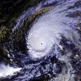
. The storm tracked generally westward for much of its duration, and on December 7 it crossed into the western Pacific Ocean. Much of its track was characterized by fluctuations in intensity, and on December 10 the cyclone attained typhoon status as it crossed the Marshall Islands
. On December 16, Paka struck Guam
and Rota
with winds of 230 km/h (145 mph), and it strengthened further to reach peak winds on December 18 over open waters. Subsequently, it underwent a steady weakening trend, and on December 23 Paka dissipated.
Typhoon Paka first impacted the Marshall Islands, where it dropped heavy rainfall and left $80 million in damage (1997 USD, $100 million 2007 USD). Later, it passed just north of Guam, where strong winds destroyed about 1,500 buildings and damaged 10,000 more; 5,000 people were left homeless, and the island experienced a complete power outage following the typhoon. Damage on the island totaled $500 million (1997 USD, $645 million 2007 USD), which warranted the retirement of its name. Paka also caused light damage in the Northern Mariana Islands
, and overall the typhoon caused no reported fatalities.
transitioned into a late-fall to early winter-type pattern, convection
from the monsoon trough
extended to the east of the International Date Line
. During late November, a westerly disturbance developed into twin trough
s on opposite sides of the equator
; the one in the Southern Hemisphere
ultimately developed into Tropical Cyclone Pam, while the one in the Northern Hemisphere
formed into an area of convection about 2000 km (1240 mi) southwest of Hawaii
. The disturbance gradually organized as it drifted north-northeastward, and on November 28 it developed into Tropical Depression Five-C about 465 km (290 mi) west-northwest of Palmyra Atoll
. Operationally, the Central Pacific Hurricane Center
(CPHC) did not begin issuing warnings on the system until December 2.
The tropical depression continued drifting north-northeastward, and failed to strengthen significantly. It turned to the west on December 1, due to the presence of a strong anticyclone
to its north with a ridge
extending westward past the International Date Line
. On December 2, based on satellite estimates, the CPHC upgraded the depression to Tropical Storm Paka while located about 1000 km (625 mi) south-southeast of Johnston Atoll
. Due to the presence of high cloud
s across the area, forecasters had difficulty at times in locating the low-level circulation. After becoming a tropical storm, Paka remained nearly stationary for about two days before resuming a slow motion to the west-southwest. It steadily intensified due to warm water temperatures, and on December 3 the storm attained winds of 105 km/h (65 mph). The next day, however, it encountered dry air and began weakening; by December 6, the winds had decreased to minimal tropical storm status for about 12 hours. Subsequently, Paka began to re-intensify, and on December 7 the storm crossed the International Date Line
into the western North Pacific Ocean with winds of 80 km/h (50 mph).
Upon entering the western North Pacific Ocean, tropical cyclone warning duties transferred from the CPHC to the Japan Meteorological Agency
(JMA), and the JMA first assessed Paka as a 65 km (40 mph) storm. The Joint Typhoon Warning Center
(JTWC) unofficially assumed warning duties for interests in the United States Department of Defense
. Paka continued to intensify after crossing the date line, and from late on December 7 through early the following day it remained a strong tropical storm. However, upper-level wind shear
increased, and it again weakened. At 1200 UTC on December 9, the JTWC assessed Paka as an 85 km/h (50 mph) tropical storm and forecast it to continue weakening. By December 10, the shear had begun to decrease as the storm moved through the Marshall Islands
, and that night the JTWC upgraded Paka to typhoon status. Paka officially attained typhoon status when JMA classified it with winds of 120 km/h (75 mph) at 0000 UTC on December 11.
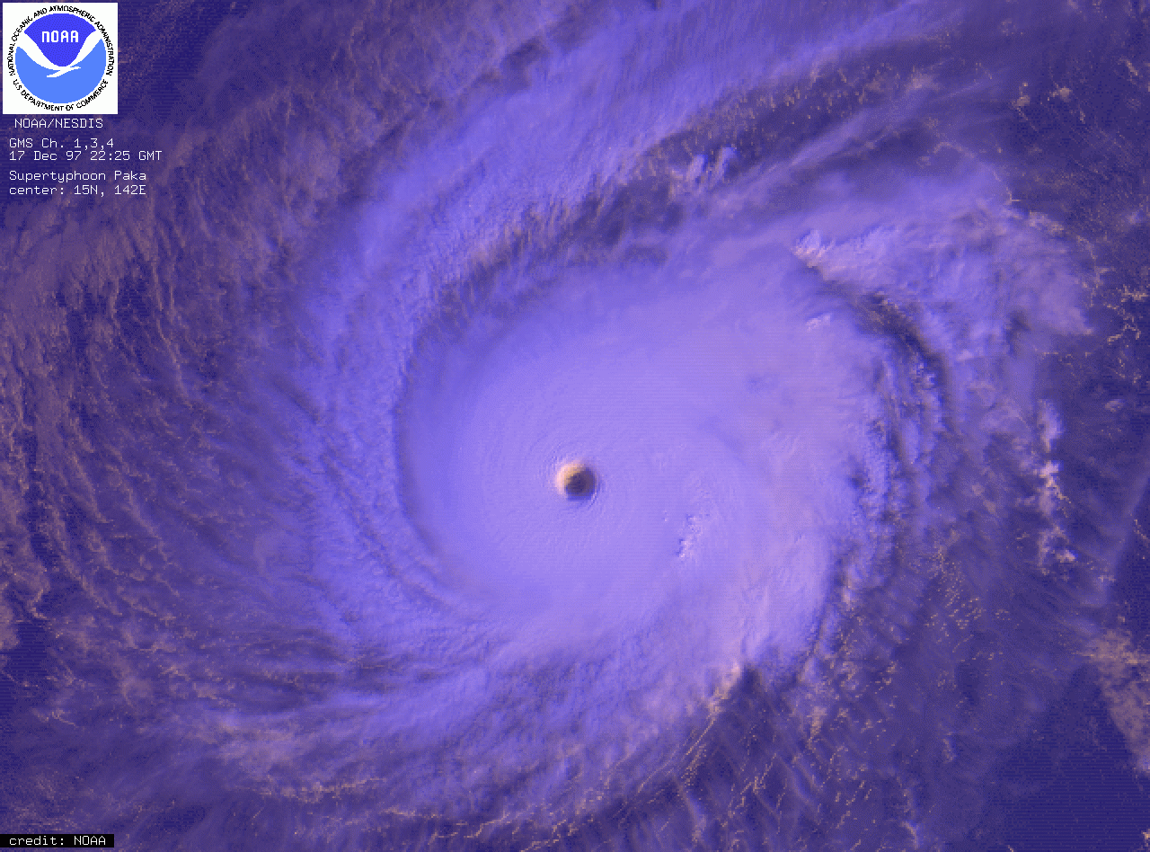 After attaining typhoon status, Paka strengthened fairly quickly, and by December 12 it reached sustained winds of 150 km/h (90 mph) for a ten-minute (10 min) duration, or 215 km/h (135 mph) over a one-minute (1 min) duration. Subsequently, it briefly weakened as its forward motion increased. However, Paka again re-intensified, and at 1200 UTC on December 14 it attained the unofficial ranking of super typhoon status while over the open Pacific Ocean. At the same time, the JMA classified it with 10 min sustained winds of 175 km/h (110 mph). After reaching its initial peak intensity, Typhoon Paka began to weaken as it approached the southern Mariana Islands
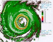
; the NEXRAD
Doppler weather radar
from Guam
revealed the presence of a primary eyewall
of 74 km (46 mi) in diameter, with a fragmented inner wall cloud of 19 km (11 mi) in diameter. Additionally, satellite imagery indicated an eyewall mesovortex
within the eye of the typhoon. It slowed and began to re-intensify as it continued westward, and at 0530 UTC on December 16 the northern portion of the outer eyewall of Paka passed over the island of Rota
; 20 minutes later, the southern portion of the inner wall cloud moved across northern Guam
. As it tracked through the Rota Channel, the center of Paka passed about 8 km (5 mi) north of the northern tip of Guam, its closest approach to the island.
Typhoon Paka continued to steadily intensify after passing the Marianas Islands, and late on December 17 it reached its peak intensity of 185 km/h (115 mph 10 min sustained) while located 440 km (275 mi) west-northwest of Guam. Early on December 18, the JTWC assessed it as attaining peak winds of 295 km/h (185 mph 1 min winds). On December 19, it entered the area of responsibility of the Philippine Atmospheric, Geophysical and Astronomical Services Administration
, or PAGASA, and was named Rubing. Shortly thereafter, Paka moved through an area of progressively increasing wind shear
, which resulted in a steady weakening trend. By December 21, winds decreased to tropical storm status. The next day, it degenerated into a tropical depression, and on December 23 JMA classified Paka as dissipated.
, several hundred residents on the island of Ebeye
fled to safer structures. The threat of Paka prevented Continental Micronesia
from flying in or out of the area.
Paka entered the Marshall Islands between Mili
and Majuro
as a tropical storm on December 10, and after strengthening into a typhoon, it left the archipelago on December 14. The cyclone affected several islands in the nation, and the Majuro
and Kwajalein
atolls reported wind gusts in excess of 75 km/h (45 mph). On Jaluit Atoll
, the typhoon dropped 217 mm (8.54 in) of precipitation in six hours, with a total of about 300 mm (11.8 in) recorded in 30 hours. Strong waves inundated low-lying islands, which flooded crops with salt water. The combination of the wind and flooding caused severe damage to banana, papaya, and lime trees across the territory. Typhoon Paka damaged 70% of the houses on Ailinglaplap Atoll
, and most of the coconut trees on the atoll were left toppled or damaged. Strong winds left large portions of Ebeye
island without electricity or telephone. The typhoon caused no reported deaths or injuries in the region, and damage was estimated at $80 million (1997 USD
, $100 million 2007 USD).
 The Guam
National Weather Service
issued a typhoon watch
on December 14, which was upgraded to a typhoon warning the next day. The Antonio B. Won Pat International Airport
was closed during the passage of Paka, with only emergency flights permitted.
Passing a short distance north of the island, Typhoon Paka produced strong winds across northern Guam
, though reliable wind reports are incomplete due to the long duration and intensity of the winds. The highest reading believed to be reliable was at Apra Harbor
. There, a station recorded a wind gust of 277 km/h (171 mph) before the sensor failed as winds shifted to the southwest; since the winds from the southwest were stronger and of greater duration, officials believe gusts there reached 297 km/h (184 mph). Additionally, Andersen Air Force Base
recorded a peak wind gust of 381 km/h (236 mph), which at the time was considered the highest wind speed on record, surpassing the 1934 world record of 372 km/h (231 mph) on Mount Washington
in New Hampshire
. However, a subsequent wind survey of the area discarded the reading at the base, as it was considered unreliable. As microbarographs are less exposed than wind sensors, pressure readings on the island are considered accurate; the lowest reading on the island was 948 mbar
(hPa) at Andersen Air Force Base. In two days, the typhoon dropped about 533 mm (21 in) of precipitation on the northern portion of the island, or about 89% of the monthly rainfall total. Waves along northern Guam reached about 11 m (35 ft) in height.
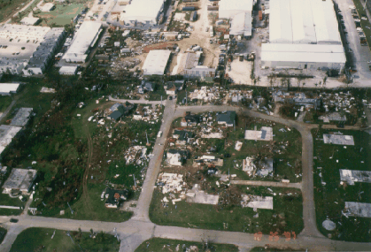
The strong winds from Paka left around 1,500 buildings destroyed on the island, of which 1,160 were single-family homes. A further 10,000 buildings sustained damage to some degree, with 60% of the homes on the island reporting major damage. In all, about 5,000 people were left homeless due to the typhoon. Additionally, an estimated 30–40 % of the public buildings received major damage. Buildings on the island made of reinforced concerted fared well, as opposed to light metal-frame structures, which more often were completely destroyed. Large tourist hotels near Hagåtña
, on which Guam is dependent, received generally minor damage, such as broken windows and damaged power generators.
A complete island-wide power outage followed the typhoon; damage to the main electrical transmission and distribution system was estimated at $16 million (1997 USD, $20 million 2007 USD). Following the passage of the typhoon, 25% of the homes on Guam were left without water. Telephone service remained working after the storm, due to most lines being underground. Strong waves washed away a few coastal roads in the northern portion of the island, leaving them temporarily closed. The waves surpassed the seawall at Apra Harbor
, damaging the road and infrastructure of the seaport; many boats were washed ashore after breaking from their moorings. Strong winds damaged a radar system and lights along the runway of the Antonio B. Won Pat International Airport
, though most airport facilities received light damage. The Andersen Air Force Base
also sustained heavy damage, with hundreds of downed trees and many facilities left damaged.
Prior to Paka, the last typhoon to strike Guam was Typhoon Omar
in 1992. Across Guam, damage was estimated at $500 million (1997 USD, $645 million 2007 USD). About 100 people were injured, but the typhoon caused no deaths on the island.
was issued for Rota
, Tinian
, and Saipan
on December 14, which was upgraded to a typhoon warning the next day. Because Paka was intensifying while passing to the south of Rota
, the first wind, or northeast through east winds, was less severe than the second wind from the southeast. Sustained winds on the island reached 145 km/h (90 mph), with gusts reaching 185 km/h (115 mph). Many trees in the mountainous portion of the island were left defoliated, which limited nesting and foraging sites for the endangered Bridled White-eye
bird. While passing to the south of the island, Paka dropped 250–300 mm (10–12 in) of rain. Damage on the island totaled $4.4 million (1997 USD). The typhoon also produced above-normal precipitation on Saipan
.
in the Marshall Islands
, residents experienced severe food shortages due to damaged crops and little rainfall. Experts estimated the entire redevelopment of its fauna would require more than a decade. As a result of the crop shortage, large-scale evacuations of the islands' residents were considered. Officials in the nation requested assistance from the Federal Emergency Management Agency
of the United States, and on March 20, 1998, the area was declared a disaster area; the declaration allowed for the usage of emergency funds.
On December 17, 1997, President
Bill Clinton
declared Guam
a federal disaster area, making it eligible for federal assistance. One week later, a disaster declaration was ordered for the Northern Mariana Islands
. Ultimately, FEMA
received 14,770 Individual Assistance Applications from residents on Guam. In turn, FEMA provided the residents with over $27 million in assistance (1997 USD, $35 million 2007 USD). The entire island of Guam was left without power after Paka. Water and sewage systems on Guam were directly affected minimally by the typhoon. With the usage of power generators, most areas of the island had water pumping
capabilities within a few days after the typhoon. The Antonio B. Won Pat International Airport
was partially reopened to daytime flights a day after the typhoon, and by a week after the passage of Paka the airport was fully re-opened.
Tropical cyclone
A tropical cyclone is a storm system characterized by a large low-pressure center and numerous thunderstorms that produce strong winds and heavy rain. Tropical cyclones strengthen when water evaporated from the ocean is released as the saturated air rises, resulting in condensation of water vapor...
in the 1997 Pacific Ocean
Pacific Ocean
The Pacific Ocean is the largest of the Earth's oceanic divisions. It extends from the Arctic in the north to the Southern Ocean in the south, bounded by Asia and Australia in the west, and the Americas in the east.At 165.2 million square kilometres in area, this largest division of the World...
hurricane
1997 Pacific hurricane season
The 1997 Pacific hurricane season was a very active hurricane season. With hundreds of deaths and billions of dollars in damage, this season was the costliest and one of the deadliest Pacific hurricane seasons. This was due to a strong El Niño...
and typhoon
1997 Pacific typhoon season
The 1997 Pacific typhoon season has no official bounds; it ran year-round in 1997, but most tropical cyclones tend to form in the northwestern Pacific Ocean between May and November. These dates conventionally delimit the period of each year when most tropical cyclones form in the northwestern...
season, and was among the strongest Pacific typhoons in the month of December. Paka, which is the Hawaiian
Hawaiian language
The Hawaiian language is a Polynesian language that takes its name from Hawaii, the largest island in the tropical North Pacific archipelago where it developed. Hawaiian, along with English, is an official language of the state of Hawaii...
name for Pat, developed on November 28 from a trough
Trough (meteorology)
A trough is an elongated region of relatively low atmospheric pressure, often associated with fronts.Unlike fronts, there is not a universal symbol for a trough on a weather chart. The weather charts in some countries or regions mark troughs by a line. In the United States, a trough may be marked...
well to the southwest of Hawaii
Hawaii
Hawaii is the newest of the 50 U.S. states , and is the only U.S. state made up entirely of islands. It is the northernmost island group in Polynesia, occupying most of an archipelago in the central Pacific Ocean, southwest of the continental United States, southeast of Japan, and northeast of...
. The storm tracked generally westward for much of its duration, and on December 7 it crossed into the western Pacific Ocean. Much of its track was characterized by fluctuations in intensity, and on December 10 the cyclone attained typhoon status as it crossed the Marshall Islands
Marshall Islands
The Republic of the Marshall Islands , , is a Micronesian nation of atolls and islands in the middle of the Pacific Ocean, just west of the International Date Line and just north of the Equator. As of July 2011 the population was 67,182...
. On December 16, Paka struck Guam
Guam
Guam is an organized, unincorporated territory of the United States located in the western Pacific Ocean. It is one of five U.S. territories with an established civilian government. Guam is listed as one of 16 Non-Self-Governing Territories by the Special Committee on Decolonization of the United...
and Rota
Rota (island)
Rota also known as the "peaceful island", is the southernmost island of the United States Commonwealth of the Northern Mariana Islands and the second southernmost of the Marianas Archipelago. It lies approximately 40 miles north-northeast of the United States territory of Guam...
with winds of 230 km/h (145 mph), and it strengthened further to reach peak winds on December 18 over open waters. Subsequently, it underwent a steady weakening trend, and on December 23 Paka dissipated.
Typhoon Paka first impacted the Marshall Islands, where it dropped heavy rainfall and left $80 million in damage (1997 USD, $100 million 2007 USD). Later, it passed just north of Guam, where strong winds destroyed about 1,500 buildings and damaged 10,000 more; 5,000 people were left homeless, and the island experienced a complete power outage following the typhoon. Damage on the island totaled $500 million (1997 USD, $645 million 2007 USD), which warranted the retirement of its name. Paka also caused light damage in the Northern Mariana Islands
Northern Mariana Islands
The Northern Mariana Islands, officially the Commonwealth of the Northern Mariana Islands , is a commonwealth in political union with the United States, occupying a strategic region of the western Pacific Ocean. It consists of 15 islands about three-quarters of the way from Hawaii to the Philippines...
, and overall the typhoon caused no reported fatalities.
Meteorological history
As the weather synoptics of the northern Pacific OceanPacific Ocean
The Pacific Ocean is the largest of the Earth's oceanic divisions. It extends from the Arctic in the north to the Southern Ocean in the south, bounded by Asia and Australia in the west, and the Americas in the east.At 165.2 million square kilometres in area, this largest division of the World...
transitioned into a late-fall to early winter-type pattern, convection
Convection
Convection is the movement of molecules within fluids and rheids. It cannot take place in solids, since neither bulk current flows nor significant diffusion can take place in solids....
from the monsoon trough
Monsoon trough
The monsoon trough is that portion of the Intertropical Convergence Zone which extends into or through a monsoon circulation, as depicted by a line on a weather map showing the locations of minimum sea level pressure, and as such, is a convergence zone between the wind patterns of the southern and...
extended to the east of the International Date Line
International Date Line
The International Date Line is a generally north-south imaginary line on the surface of the Earth, passing through the middle of the Pacific Ocean, that designates the place where each calendar day begins...
. During late November, a westerly disturbance developed into twin trough
Trough (meteorology)
A trough is an elongated region of relatively low atmospheric pressure, often associated with fronts.Unlike fronts, there is not a universal symbol for a trough on a weather chart. The weather charts in some countries or regions mark troughs by a line. In the United States, a trough may be marked...
s on opposite sides of the equator
Equator
An equator is the intersection of a sphere's surface with the plane perpendicular to the sphere's axis of rotation and containing the sphere's center of mass....
; the one in the Southern Hemisphere
Southern Hemisphere
The Southern Hemisphere is the part of Earth that lies south of the equator. The word hemisphere literally means 'half ball' or "half sphere"...
ultimately developed into Tropical Cyclone Pam, while the one in the Northern Hemisphere
Northern Hemisphere
The Northern Hemisphere is the half of a planet that is north of its equator—the word hemisphere literally means “half sphere”. It is also that half of the celestial sphere north of the celestial equator...
formed into an area of convection about 2000 km (1240 mi) southwest of Hawaii
Hawaii
Hawaii is the newest of the 50 U.S. states , and is the only U.S. state made up entirely of islands. It is the northernmost island group in Polynesia, occupying most of an archipelago in the central Pacific Ocean, southwest of the continental United States, southeast of Japan, and northeast of...
. The disturbance gradually organized as it drifted north-northeastward, and on November 28 it developed into Tropical Depression Five-C about 465 km (290 mi) west-northwest of Palmyra Atoll
Palmyra Atoll
Palmyra Atoll is an essentially unoccupied equatorial Northern Pacific atoll administered as an unorganized incorporated territory by the United States federal government...
. Operationally, the Central Pacific Hurricane Center
Central Pacific Hurricane Center
The Central Pacific Hurricane Center of the United States National Weather Service is the official body responsible for tracking and issuing tropical cyclone warnings, watches, advisories, discussions, and statements for the Central North Pacific Basin...
(CPHC) did not begin issuing warnings on the system until December 2.
The tropical depression continued drifting north-northeastward, and failed to strengthen significantly. It turned to the west on December 1, due to the presence of a strong anticyclone
Anticyclone
An anticyclone is a weather phenomenon defined by the United States' National Weather Service's glossary as "[a] large-scale circulation of winds around a central region of high atmospheric pressure, clockwise in the Northern Hemisphere, counterclockwise in the Southern Hemisphere"...
to its north with a ridge
Ridge (meteorology)
A ridge is an elongated region of relatively high atmospheric pressure, the opposite of a trough....
extending westward past the International Date Line
International Date Line
The International Date Line is a generally north-south imaginary line on the surface of the Earth, passing through the middle of the Pacific Ocean, that designates the place where each calendar day begins...
. On December 2, based on satellite estimates, the CPHC upgraded the depression to Tropical Storm Paka while located about 1000 km (625 mi) south-southeast of Johnston Atoll
Johnston Atoll
Johnston Atoll is a atoll in the North Pacific Ocean about west of Hawaii. There are four islands located on the coral reef platform, two natural islands, Johnston Island and Sand Island, which have been expanded by coral dredging, as well as North Island and East Island , an additional two...
. Due to the presence of high cloud
Cloud
A cloud is a visible mass of liquid droplets or frozen crystals made of water and/or various chemicals suspended in the atmosphere above the surface of a planetary body. They are also known as aerosols. Clouds in Earth's atmosphere are studied in the cloud physics branch of meteorology...
s across the area, forecasters had difficulty at times in locating the low-level circulation. After becoming a tropical storm, Paka remained nearly stationary for about two days before resuming a slow motion to the west-southwest. It steadily intensified due to warm water temperatures, and on December 3 the storm attained winds of 105 km/h (65 mph). The next day, however, it encountered dry air and began weakening; by December 6, the winds had decreased to minimal tropical storm status for about 12 hours. Subsequently, Paka began to re-intensify, and on December 7 the storm crossed the International Date Line
International Date Line
The International Date Line is a generally north-south imaginary line on the surface of the Earth, passing through the middle of the Pacific Ocean, that designates the place where each calendar day begins...
into the western North Pacific Ocean with winds of 80 km/h (50 mph).
Upon entering the western North Pacific Ocean, tropical cyclone warning duties transferred from the CPHC to the Japan Meteorological Agency
Japan Meteorological Agency
The or JMA, is the Japanese government's weather service. Charged with gathering and reporting weather data and forecasts in Japan, it is a semi-autonomous part of the Ministry of Land, Infrastructure and Transport...
(JMA), and the JMA first assessed Paka as a 65 km (40 mph) storm. The Joint Typhoon Warning Center
Joint Typhoon Warning Center
The Joint Typhoon Warning Center is a joint United States Navy – United States Air Force task force located at the Naval Maritime Forecast Center in Pearl Harbor, Hawaii...
(JTWC) unofficially assumed warning duties for interests in the United States Department of Defense
United States Department of Defense
The United States Department of Defense is the U.S...
. Paka continued to intensify after crossing the date line, and from late on December 7 through early the following day it remained a strong tropical storm. However, upper-level wind shear
Wind shear
Wind shear, sometimes referred to as windshear or wind gradient, is a difference in wind speed and direction over a relatively short distance in the atmosphere...
increased, and it again weakened. At 1200 UTC on December 9, the JTWC assessed Paka as an 85 km/h (50 mph) tropical storm and forecast it to continue weakening. By December 10, the shear had begun to decrease as the storm moved through the Marshall Islands
Marshall Islands
The Republic of the Marshall Islands , , is a Micronesian nation of atolls and islands in the middle of the Pacific Ocean, just west of the International Date Line and just north of the Equator. As of July 2011 the population was 67,182...
, and that night the JTWC upgraded Paka to typhoon status. Paka officially attained typhoon status when JMA classified it with winds of 120 km/h (75 mph) at 0000 UTC on December 11.
Mariana Islands
The Mariana Islands are an arc-shaped archipelago made up by the summits of 15 volcanic mountains in the north-western Pacific Ocean between the 12th and 21st parallels north and along the 145th meridian east...
; the NEXRAD
NEXRAD
NEXRAD or Nexrad is a network of 159 high-resolution Doppler weather radars operated by the National Weather Service, an agency of the National Oceanic and Atmospheric Administration within the United States Department of Commerce...
Doppler weather radar
Weather radar
Weather radar, also called weather surveillance radar and Doppler weather radar, is a type of radar used to locate precipitation, calculate its motion, estimate its type . Modern weather radars are mostly pulse-Doppler radars, capable of detecting the motion of rain droplets in addition to the...
from Guam
Guam
Guam is an organized, unincorporated territory of the United States located in the western Pacific Ocean. It is one of five U.S. territories with an established civilian government. Guam is listed as one of 16 Non-Self-Governing Territories by the Special Committee on Decolonization of the United...
revealed the presence of a primary eyewall
Eye (cyclone)
The eye is a region of mostly calm weather found at the center of strong tropical cyclones. The eye of a storm is a roughly circular area and typically 30–65 km in diameter. It is surrounded by the eyewall, a ring of towering thunderstorms where the second most severe weather of a cyclone...
of 74 km (46 mi) in diameter, with a fragmented inner wall cloud of 19 km (11 mi) in diameter. Additionally, satellite imagery indicated an eyewall mesovortex
Eye (cyclone)
The eye is a region of mostly calm weather found at the center of strong tropical cyclones. The eye of a storm is a roughly circular area and typically 30–65 km in diameter. It is surrounded by the eyewall, a ring of towering thunderstorms where the second most severe weather of a cyclone...
within the eye of the typhoon. It slowed and began to re-intensify as it continued westward, and at 0530 UTC on December 16 the northern portion of the outer eyewall of Paka passed over the island of Rota
Rota (island)
Rota also known as the "peaceful island", is the southernmost island of the United States Commonwealth of the Northern Mariana Islands and the second southernmost of the Marianas Archipelago. It lies approximately 40 miles north-northeast of the United States territory of Guam...
; 20 minutes later, the southern portion of the inner wall cloud moved across northern Guam
Guam
Guam is an organized, unincorporated territory of the United States located in the western Pacific Ocean. It is one of five U.S. territories with an established civilian government. Guam is listed as one of 16 Non-Self-Governing Territories by the Special Committee on Decolonization of the United...
. As it tracked through the Rota Channel, the center of Paka passed about 8 km (5 mi) north of the northern tip of Guam, its closest approach to the island.
Typhoon Paka continued to steadily intensify after passing the Marianas Islands, and late on December 17 it reached its peak intensity of 185 km/h (115 mph 10 min sustained) while located 440 km (275 mi) west-northwest of Guam. Early on December 18, the JTWC assessed it as attaining peak winds of 295 km/h (185 mph 1 min winds). On December 19, it entered the area of responsibility of the Philippine Atmospheric, Geophysical and Astronomical Services Administration
Philippine Atmospheric, Geophysical and Astronomical Services Administration
The Philippine Atmospheric, Geophysical and Astronomical Services Administration is a Philippine national institution dedicated to provide flood and typhoon warnings, public weather forecasts and advisories, meteorological, astronomical, climatological, and other specialized information and...
, or PAGASA, and was named Rubing. Shortly thereafter, Paka moved through an area of progressively increasing wind shear
Wind shear
Wind shear, sometimes referred to as windshear or wind gradient, is a difference in wind speed and direction over a relatively short distance in the atmosphere...
, which resulted in a steady weakening trend. By December 21, winds decreased to tropical storm status. The next day, it degenerated into a tropical depression, and on December 23 JMA classified Paka as dissipated.
Marshall Islands
Prior to the typhoon passing through the Marshall IslandsMarshall Islands
The Republic of the Marshall Islands , , is a Micronesian nation of atolls and islands in the middle of the Pacific Ocean, just west of the International Date Line and just north of the Equator. As of July 2011 the population was 67,182...
, several hundred residents on the island of Ebeye
Ebeye
Ebeye is the most populous island of Kwajalein Atoll in the Marshall Islands, as well as the center for Marshallese culture in the Ralik Chain of the archipelago. Settled on 80 acres of land, it has a population of more than 15,000. Over 50% of the population is estimated to be under the age of...
fled to safer structures. The threat of Paka prevented Continental Micronesia
Continental Micronesia
Continental Micronesia, Inc. is a wholly owned subsidiary of Continental Airlines. It operated daily flights to Honolulu, Hawaii, as well as international services to Asia, Micronesia and Australia from its base of operations at Antonio B. Won Pat International Airport on Guam, a U.S. territory in...
from flying in or out of the area.
Paka entered the Marshall Islands between Mili
Mili Atoll
Mili Atoll is a coral atoll of 92 islands in the Pacific Ocean, and forms a legislative district of the Ratak Chain of the Marshall Islands. It is located approximately southeast of Arno Its total land area is making it the second largest of the Marshall Islands after Kwajalein. It encloses a...
and Majuro
Majuro
Majuro , is a large coral atoll of 64 islands in the Pacific Ocean, and forms a legislative district of the Ratak Chain of the Marshall Islands. The atoll itself has a land area of and encloses a lagoon of...
as a tropical storm on December 10, and after strengthening into a typhoon, it left the archipelago on December 14. The cyclone affected several islands in the nation, and the Majuro
Majuro
Majuro , is a large coral atoll of 64 islands in the Pacific Ocean, and forms a legislative district of the Ratak Chain of the Marshall Islands. The atoll itself has a land area of and encloses a lagoon of...
and Kwajalein
Kwajalein
Kwajalein Atoll , is part of the Republic of the Marshall Islands . The southernmost and largest island in the atoll is named Kwajalein Island. English-speaking residents of the U.S...
atolls reported wind gusts in excess of 75 km/h (45 mph). On Jaluit Atoll
Jaluit Atoll
Jaluit Atoll is a large coral atoll of 91 islands in the Pacific Ocean, and forms a legislative district of the Ralik Chain of the Marshall Islands. Its total land area is only , but it encloses a lagoon with an area of . Most of the land area is on largest islet of Jaluit . Jaluit is located...
, the typhoon dropped 217 mm (8.54 in) of precipitation in six hours, with a total of about 300 mm (11.8 in) recorded in 30 hours. Strong waves inundated low-lying islands, which flooded crops with salt water. The combination of the wind and flooding caused severe damage to banana, papaya, and lime trees across the territory. Typhoon Paka damaged 70% of the houses on Ailinglaplap Atoll
Ailinglaplap Atoll
Ailinglaplap or Ailinglapalap is a coral atoll of 56 islands in the Pacific Ocean, and forms a legislative district of the Ralik Chain in the Marshall Islands. It is located northwest of Jaluit Atoll. Its total land area is only , but it encloses a lagoon of...
, and most of the coconut trees on the atoll were left toppled or damaged. Strong winds left large portions of Ebeye
Ebeye
Ebeye is the most populous island of Kwajalein Atoll in the Marshall Islands, as well as the center for Marshallese culture in the Ralik Chain of the archipelago. Settled on 80 acres of land, it has a population of more than 15,000. Over 50% of the population is estimated to be under the age of...
island without electricity or telephone. The typhoon caused no reported deaths or injuries in the region, and damage was estimated at $80 million (1997 USD
United States dollar
The United States dollar , also referred to as the American dollar, is the official currency of the United States of America. It is divided into 100 smaller units called cents or pennies....
, $100 million 2007 USD).
Guam
Guam
Guam is an organized, unincorporated territory of the United States located in the western Pacific Ocean. It is one of five U.S. territories with an established civilian government. Guam is listed as one of 16 Non-Self-Governing Territories by the Special Committee on Decolonization of the United...
National Weather Service
National Weather Service
The National Weather Service , once known as the Weather Bureau, is one of the six scientific agencies that make up the National Oceanic and Atmospheric Administration of the United States government...
issued a typhoon watch
Tropical cyclone warnings and watches
Warnings and watches are two levels of alert issued by national weather forecasting bodies to coastal areas threatened by the imminent approach of a tropical cyclone of tropical storm or hurricane intensity. They are notices to the local population and civil authorities to make appropriate...
on December 14, which was upgraded to a typhoon warning the next day. The Antonio B. Won Pat International Airport
Antonio B. Won Pat International Airport
Antonio B. Won Pat International Airport , also known as Guam International Airport, is an airport located in Tamuning and Barrigada, three miles east of the capital city of Hagåtña in the U.S. territory of Guam. It is named for Antonio Borja Won Pat, the first delegate from Guam to the United...
was closed during the passage of Paka, with only emergency flights permitted.
Passing a short distance north of the island, Typhoon Paka produced strong winds across northern Guam
Guam
Guam is an organized, unincorporated territory of the United States located in the western Pacific Ocean. It is one of five U.S. territories with an established civilian government. Guam is listed as one of 16 Non-Self-Governing Territories by the Special Committee on Decolonization of the United...
, though reliable wind reports are incomplete due to the long duration and intensity of the winds. The highest reading believed to be reliable was at Apra Harbor
Apra Harbor
Apra Harbor is a deep-water port on the western side of Guam in the Mariana Islands. The harbor is formed by Orote Peninsula in the south and Cabras Island in the north. To the south, the harbor narrows and then widens again to form an inner harbor. The southern end of the harbor is the location...
. There, a station recorded a wind gust of 277 km/h (171 mph) before the sensor failed as winds shifted to the southwest; since the winds from the southwest were stronger and of greater duration, officials believe gusts there reached 297 km/h (184 mph). Additionally, Andersen Air Force Base
Andersen Air Force Base
Andersen Air Force Base is a United States Air Force base located approximately northeast of Yigo in the United States territory of Guam....
recorded a peak wind gust of 381 km/h (236 mph), which at the time was considered the highest wind speed on record, surpassing the 1934 world record of 372 km/h (231 mph) on Mount Washington
Mount Washington (New Hampshire)
Mount Washington is the highest peak in the Northeastern United States at , famous for dangerously erratic weather. For 76 years, a weather observatory on the summit held the record for the highest wind gust directly measured at the Earth's surface, , on the afternoon of April 12, 1934...
in New Hampshire
New Hampshire
New Hampshire is a state in the New England region of the northeastern United States of America. The state was named after the southern English county of Hampshire. It is bordered by Massachusetts to the south, Vermont to the west, Maine and the Atlantic Ocean to the east, and the Canadian...
. However, a subsequent wind survey of the area discarded the reading at the base, as it was considered unreliable. As microbarographs are less exposed than wind sensors, pressure readings on the island are considered accurate; the lowest reading on the island was 948 mbar
Bar (unit)
The bar is a unit of pressure equal to 100 kilopascals, and roughly equal to the atmospheric pressure on Earth at sea level. Other units derived from the bar are the megabar , kilobar , decibar , centibar , and millibar...
(hPa) at Andersen Air Force Base. In two days, the typhoon dropped about 533 mm (21 in) of precipitation on the northern portion of the island, or about 89% of the monthly rainfall total. Waves along northern Guam reached about 11 m (35 ft) in height.
The strong winds from Paka left around 1,500 buildings destroyed on the island, of which 1,160 were single-family homes. A further 10,000 buildings sustained damage to some degree, with 60% of the homes on the island reporting major damage. In all, about 5,000 people were left homeless due to the typhoon. Additionally, an estimated 30–40 % of the public buildings received major damage. Buildings on the island made of reinforced concerted fared well, as opposed to light metal-frame structures, which more often were completely destroyed. Large tourist hotels near Hagåtña
Hagåtña, Guam
Hagåtña , formerly English Agana and in Spanish Agaña, is the capital of the United States island territory of Guam. It is the island's second smallest village in both area and population. From the 18th through mid 20th century, it was Guam's population center...
, on which Guam is dependent, received generally minor damage, such as broken windows and damaged power generators.
A complete island-wide power outage followed the typhoon; damage to the main electrical transmission and distribution system was estimated at $16 million (1997 USD, $20 million 2007 USD). Following the passage of the typhoon, 25% of the homes on Guam were left without water. Telephone service remained working after the storm, due to most lines being underground. Strong waves washed away a few coastal roads in the northern portion of the island, leaving them temporarily closed. The waves surpassed the seawall at Apra Harbor
Apra Harbor
Apra Harbor is a deep-water port on the western side of Guam in the Mariana Islands. The harbor is formed by Orote Peninsula in the south and Cabras Island in the north. To the south, the harbor narrows and then widens again to form an inner harbor. The southern end of the harbor is the location...
, damaging the road and infrastructure of the seaport; many boats were washed ashore after breaking from their moorings. Strong winds damaged a radar system and lights along the runway of the Antonio B. Won Pat International Airport
Antonio B. Won Pat International Airport
Antonio B. Won Pat International Airport , also known as Guam International Airport, is an airport located in Tamuning and Barrigada, three miles east of the capital city of Hagåtña in the U.S. territory of Guam. It is named for Antonio Borja Won Pat, the first delegate from Guam to the United...
, though most airport facilities received light damage. The Andersen Air Force Base
Andersen Air Force Base
Andersen Air Force Base is a United States Air Force base located approximately northeast of Yigo in the United States territory of Guam....
also sustained heavy damage, with hundreds of downed trees and many facilities left damaged.
Prior to Paka, the last typhoon to strike Guam was Typhoon Omar
Typhoon Omar
Super Typhoon Omar was the 15th tropical depression, the 15th named storm, and the 9th typhoon of the 1992 Pacific typhoon season...
in 1992. Across Guam, damage was estimated at $500 million (1997 USD, $645 million 2007 USD). About 100 people were injured, but the typhoon caused no deaths on the island.
Northern Mariana Islands
A typhoon watchTropical cyclone warnings and watches
Warnings and watches are two levels of alert issued by national weather forecasting bodies to coastal areas threatened by the imminent approach of a tropical cyclone of tropical storm or hurricane intensity. They are notices to the local population and civil authorities to make appropriate...
was issued for Rota
Rota (island)
Rota also known as the "peaceful island", is the southernmost island of the United States Commonwealth of the Northern Mariana Islands and the second southernmost of the Marianas Archipelago. It lies approximately 40 miles north-northeast of the United States territory of Guam...
, Tinian
Tinian
Tinian is one of the three principal islands of the Commonwealth of the Northern Mariana Islands.-Geography:Tinian is about 5 miles southwest of its sister island, Saipan, from which it is separated by the Saipan Channel. It has a land area of 39 sq.mi....
, and Saipan
Saipan
Saipan is the largest island of the United States Commonwealth of the Northern Mariana Islands , a chain of 15 tropical islands belonging to the Marianas archipelago in the western Pacific Ocean with a total area of . The 2000 census population was 62,392...
on December 14, which was upgraded to a typhoon warning the next day. Because Paka was intensifying while passing to the south of Rota
Rota (island)
Rota also known as the "peaceful island", is the southernmost island of the United States Commonwealth of the Northern Mariana Islands and the second southernmost of the Marianas Archipelago. It lies approximately 40 miles north-northeast of the United States territory of Guam...
, the first wind, or northeast through east winds, was less severe than the second wind from the southeast. Sustained winds on the island reached 145 km/h (90 mph), with gusts reaching 185 km/h (115 mph). Many trees in the mountainous portion of the island were left defoliated, which limited nesting and foraging sites for the endangered Bridled White-eye
Bridled White-eye
The Bridled White-eye is a species of bird in the Zosteropidae family.It is endemic to the Mariana Islands, where it is today restricted to the islands of Tinian, Saipan and Aguijan in the Northern Mariana Islands...
bird. While passing to the south of the island, Paka dropped 250–300 mm (10–12 in) of rain. Damage on the island totaled $4.4 million (1997 USD). The typhoon also produced above-normal precipitation on Saipan
Saipan
Saipan is the largest island of the United States Commonwealth of the Northern Mariana Islands , a chain of 15 tropical islands belonging to the Marianas archipelago in the western Pacific Ocean with a total area of . The 2000 census population was 62,392...
.
Aftermath
Following the passage of the typhoon in the Ailinglaplap AtollAilinglaplap Atoll
Ailinglaplap or Ailinglapalap is a coral atoll of 56 islands in the Pacific Ocean, and forms a legislative district of the Ralik Chain in the Marshall Islands. It is located northwest of Jaluit Atoll. Its total land area is only , but it encloses a lagoon of...
in the Marshall Islands
Marshall Islands
The Republic of the Marshall Islands , , is a Micronesian nation of atolls and islands in the middle of the Pacific Ocean, just west of the International Date Line and just north of the Equator. As of July 2011 the population was 67,182...
, residents experienced severe food shortages due to damaged crops and little rainfall. Experts estimated the entire redevelopment of its fauna would require more than a decade. As a result of the crop shortage, large-scale evacuations of the islands' residents were considered. Officials in the nation requested assistance from the Federal Emergency Management Agency
Federal Emergency Management Agency
The Federal Emergency Management Agency is an agency of the United States Department of Homeland Security, initially created by Presidential Reorganization Plan No. 1 of 1978 and implemented by two Executive Orders...
of the United States, and on March 20, 1998, the area was declared a disaster area; the declaration allowed for the usage of emergency funds.
On December 17, 1997, President
President of the United States
The President of the United States of America is the head of state and head of government of the United States. The president leads the executive branch of the federal government and is the commander-in-chief of the United States Armed Forces....
Bill Clinton
Bill Clinton
William Jefferson "Bill" Clinton is an American politician who served as the 42nd President of the United States from 1993 to 2001. Inaugurated at age 46, he was the third-youngest president. He took office at the end of the Cold War, and was the first president of the baby boomer generation...
declared Guam
Guam
Guam is an organized, unincorporated territory of the United States located in the western Pacific Ocean. It is one of five U.S. territories with an established civilian government. Guam is listed as one of 16 Non-Self-Governing Territories by the Special Committee on Decolonization of the United...
a federal disaster area, making it eligible for federal assistance. One week later, a disaster declaration was ordered for the Northern Mariana Islands
Northern Mariana Islands
The Northern Mariana Islands, officially the Commonwealth of the Northern Mariana Islands , is a commonwealth in political union with the United States, occupying a strategic region of the western Pacific Ocean. It consists of 15 islands about three-quarters of the way from Hawaii to the Philippines...
. Ultimately, FEMA
Federal Emergency Management Agency
The Federal Emergency Management Agency is an agency of the United States Department of Homeland Security, initially created by Presidential Reorganization Plan No. 1 of 1978 and implemented by two Executive Orders...
received 14,770 Individual Assistance Applications from residents on Guam. In turn, FEMA provided the residents with over $27 million in assistance (1997 USD, $35 million 2007 USD). The entire island of Guam was left without power after Paka. Water and sewage systems on Guam were directly affected minimally by the typhoon. With the usage of power generators, most areas of the island had water pumping
Water pumping
The pumping of water is a basic and practical technique, far more practical than scooping it up with one's hands or lifting it in a hand-held bucket. This is true whether the water is drawn from a fresh source, moved to a needed location, purified, or used for irrigation, washing, or sewage...
capabilities within a few days after the typhoon. The Antonio B. Won Pat International Airport
Antonio B. Won Pat International Airport
Antonio B. Won Pat International Airport , also known as Guam International Airport, is an airport located in Tamuning and Barrigada, three miles east of the capital city of Hagåtña in the U.S. territory of Guam. It is named for Antonio Borja Won Pat, the first delegate from Guam to the United...
was partially reopened to daytime flights a day after the typhoon, and by a week after the passage of Paka the airport was fully re-opened.
Retirement
Due to the heavy damage from the typhoon, the Central Pacific Hurricane Center requested the retirement of the name in April 2006; the name Paka was replaced with Pama.See also
- List of tropical cyclones
- List of retired Pacific hurricane names
- Timeline of the 1997 Pacific hurricane seasonTimeline of the 1997 Pacific hurricane seasonThe 1997 Pacific hurricane season was the most active season since the 1994 season, producing 24 tropical depressions, 19 of which became tropical storms or hurricanes. The season officially started on May 15, 1997 in the Eastern Pacific—designated as the area east of 140°W—and on June 1, 1997...