

Kwajalein
Encyclopedia
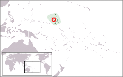
Marshall Islands
The Republic of the Marshall Islands , , is a Micronesian nation of atolls and islands in the middle of the Pacific Ocean, just west of the International Date Line and just north of the Equator. As of July 2011 the population was 67,182...
(RMI). The southernmost and largest island in the atoll is named Kwajalein Island. English-speaking residents of the U.S. facilities have referred to the island by the shortened name, Kwaj (ˈ).
The atoll
Atoll
An atoll is a coral island that encircles a lagoon partially or completely.- Usage :The word atoll comes from the Dhivehi word atholhu OED...
lies in the Ralik Chain
Ralik Chain
The Ralik Chain is a chain of islands within the island nation of the Marshall Islands. Ralik means "sunset". It lies just to the west of the country's other island chain, the Ratak Chain...
, 2,100 nautical miles (3900 km) southwest of Honolulu, Hawaii, at 8°43′N 167°44′E.
Geography
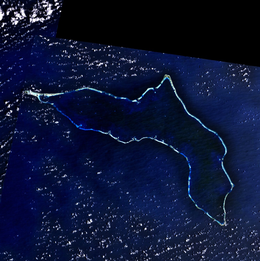
Kwajalein is one of the world's largest coral atollsAtoll
An atoll is a coral island that encircles a lagoon partially or completely.- Usage :The word atoll comes from the Dhivehi word atholhu OED...
as measured by area of enclosed water. Comprising 97 islands and islets, it has a land area of 16.4 km² (6.33 mi²), and surrounds one of the largest lagoon
Lagoon
A lagoon is a body of shallow sea water or brackish water separated from the sea by some form of barrier. The EU's habitat directive defines lagoons as "expanses of shallow coastal salt water, of varying salinity or water volume, wholly or partially separated from the sea by sand banks or shingle,...
s in the world, with an area of 2174 km² (839 mi²).
Kwajalein Island
Kwajalein Island is the southernmost, and the largest, of the islands in the Kwajalein atoll. The northernmost, and second largest, island is Roi-NamurRoi-Namur
Roi-Namur is an island in the northern part of the Kwajalein atoll in the Marshall Islands.Occupied by Japanese forces prior to World War II, it was the target of the U.S. 4th Marine Division in the Battle of Kwajalein, in February 1944....
.
The population of Kwajalein islet is currently around 1,000 individuals, mostly Americans and a small number of Marshall Islanders and other nationals, all of whom have express permission from the U.S. Army
United States Army
The United States Army is the main branch of the United States Armed Forces responsible for land-based military operations. It is the largest and oldest established branch of the U.S. military, and is one of seven U.S. uniformed services...
to live there. Approximately 13,500 Marshallese citizens live on the atoll, most on Ebeye Island.
Water temperature of 81 °F (27.2 °C) degrees and 100 feet (30.5 m) underwater visibility are common on the ocean side of the atoll.
Passes near Kwajalein Island
- SAR Pass (Search And Rescue Pass) is closest to Kwajalein on the West reef. This pass is manmade and was created in the mid 1950s, it is very narrow and shallow compared to the other natural passes in the lagoon and is only used by small boats.
- South Pass is also on the West reef, north of SAR Pass. It is very wide.
- Gea Pass is a deep water pass between Gea and Ninni islands.
- Bigej Pass is the first pass on the East reef North of Kwajalein & Ebeye.
Other islands in the Kwajalein atoll
.gif)
- Bigej is uninhabited and has no buildings on it but people from Kwajalein island in the south of the atoll come up to visit it for picnics and camping. It is covered with tropical palm trees and jungle. It is a site of cultural significance to the indigenous people of Kwajalein atoll, as are most of the small islands throughout the atoll. Some Kwajalein atoll landowners have proposed developing Bigej to look similar to the landscaped beauty of Kwajalein islet, for the exclusive use of Kwajalein atoll landowners and their families. Recently Kwajalein atoll landowners have already begun resettling Bigej, establishing several tents and simple homes there along the southern lagoon side.
- Little Bustard (, wo) and Big Bustard (, ye) are the first and second islets respectively north of Kwajalein island on the East reef, and are the only islets between Kwajalein and EbeyeEbeyeEbeye is the most populous island of Kwajalein Atoll in the Marshall Islands, as well as the center for Marshallese culture in the Ralik Chain of the archipelago. Settled on 80 acres of land, it has a population of more than 15,000. Over 50% of the population is estimated to be under the age of...
. During low tide and with protective boots, it is possible to wade across the reef between Kwajalein and Little Bustard. - Ebeye is not part of the Reagan Test SiteRonald Reagan Ballistic Missile Defense Test SiteThe Ronald Reagan Ballistic Missile Defense Test Site, commonly referred to as the Reagan Test Site , is a missile test range in the Pacific Ocean. It covers about and includes rocket launch sites at the Kwajalein Atoll , Wake Island, and Aur Atoll. It primarily functions as a test facility for U.S...
; it is a MarshalleseMarshall IslandsThe Republic of the Marshall Islands , , is a Micronesian nation of atolls and islands in the middle of the Pacific Ocean, just west of the International Date Line and just north of the Equator. As of July 2011 the population was 67,182...
island-city with shops, restaurants and an active commercial port, It has the largest population in the atoll, with approximately 13,000 residents living on 80 acres (320,000 m²) of land. Inhabitants are mostly Marshall Islanders but include a small population of migrants and volunteers from other island groups and nations. Ebeye is one of the most densely populated places in the world. Many of its residents live in poverty. A coral reef (visible and able to be traveled at low tide) links them to Kwajalein and the rest of the outside world. It is the administrative center of the Republic of the Marshall Islands at Kwajalein Atoll, and the Kwajalein Atoll Local Government (KALGOV). It is completely separate from the United States military operations in the atoll. - Ebadon (, ye) is located at the westernmost tip of the atoll. It was the second-largest island in the atoll before the formation of Roi-Namur. Like Ebeye, it falls fully under the jurisdiction of the Republic of the Marshall Islands and is not part of the Reagan Test Site. The village of Ebadon was much more largely populated before the war and it was where some of the irooj (chiefs) of Kwajalein Atoll grew up. Like many other key islets in the atoll, it has much cultural and spiritual significance in Marshallese cosmology.
- Enmat (, ye) is "mo" or taboo, birthplace of the irooj (chiefly families) and off-limits to anyone without the blessing of the IroijlaplapIroijlaplapIroijlaplap is the title given to the paramount chiefs in the Marshall Islands. An ordinary chief holds the title of Iroij ....
(paramount chief). The remains of a small Marshallese village and burial sites are still intact, but this island is located in the Mid-Atoll Corridor, and no one can reside there or on surrounding islands due to missile tests. - Ennylabagen (, ya), or "Carlos" Islet, is also site of a small Marshall Islander community that has decreased in size in recent decades but was once a bigger village. Until recently, it was actively utilized by the Reagan Test Site for tracking activities during missions, and has been one of the only non-restricted Marshallese-populated islands used by the United States Army. As such, power and clean drinking water were provided to this island free-of-charge like on the other military-leased islands. This is likely to be phased out if the island ceases to be used for future mission support.
- Enubuj (, ya), or "Carlson" Islet which was its 1944 World War II U.S. operation codename, is situated next to Kwajalein Islet to the northwest. It was from this island that U.S. forces launched their amphibious invasion of Kwajalein island. Today, it is the site of a small Marshallese village with a church and small cemetery. The sunken vessel Prinz EugenGerman cruiser Prinz EugenPrinz Eugen was an Admiral Hipper-class heavy cruiser, the third member of the class of five vessels. She served with the German Kriegsmarine during World War II. The ship was laid down in April 1936 and launched August 1938; Prinz Eugen entered service after the outbreak of war, in August 1940...
, used during the Bikini AtollBikini AtollBikini Atoll is an atoll, listed as a World Heritage Site, in the Micronesian Islands of the Pacific Ocean, part of Republic of the Marshall Islands....
atomic weapons tests, is located here along the islet's northern lagoon side. - Gugeegue or Gugegwe (ˈɡuːdʒiɡuː ; Marshallese: , k) is an islet north of EbeyeEbeyeEbeye is the most populous island of Kwajalein Atoll in the Marshall Islands, as well as the center for Marshallese culture in the Ralik Chain of the archipelago. Settled on 80 acres of land, it has a population of more than 15,000. Over 50% of the population is estimated to be under the age of...
, and is the northernmost point of the concreteConcreteConcrete is a composite construction material, composed of cement and other cementitious materials such as fly ash and slag cement, aggregate , water and chemical admixtures.The word concrete comes from the Latin word...
causewayCausewayIn modern usage, a causeway is a road or railway elevated, usually across a broad body of water or wetland.- Etymology :When first used, the word appeared in a form such as “causey way” making clear its derivation from the earlier form “causey”. This word seems to have come from the same source by...
connecting the islets between them. Gugeegue is just south of the Bigej Pass which separates it from BigejBigejBigej or Begej Island is part of Kwajalein Atoll in the Ralik Chain in the Republic of the Marshall Islands , 2,100 nautical miles southwest of Honolulu, Hawaii....
islet. - Legan (, ha) is uninhabited but does have a few buildings on the southern part of the island. Most of the island is thick jungle like most islands in the Marshall Islands. Unlike most islands though, Legan has a very small lake in the middle.
- Meck is a launch site for anti-ballistic missileAnti-ballistic missileAn anti-ballistic missile is a missile designed to counter ballistic missiles .A ballistic missile is used to deliver nuclear, chemical, biological or conventional warheads in a ballistic flight trajectory. The term "anti-ballistic missile" describes any antimissile system designed to counter...
s and is probably the most restricted island of all the U.S.-leased sites. - NellNell IslandNell Island is part of Kwajalein Atoll in the Ralik Chain in the Republic of the Marshall Islands , 2,100 nautical miles southwest of Honolulu, Hawaii. It lies at a convergence of deep, narrow, protected channels and small islands...
has a unique convergence of protected channels and small islands. The Nell area is unique and a popular destination for locals and Americans sailing through the area with proper permissions from the Republic of the Marshall Islands. (All non-leased islands are strictly off-limits to American base residents and personnel without applying for official permission.) - OmelekOmelek IslandOmelek Island is part of the Kwajalein Atoll in the Republic of the Marshall Islands. It is controlled by the United States military under a long-term lease and is part of the Ronald Reagan Ballistic Missile Defense Test Site.-Geography:The Island is about in size...
is uninhabited and leased by the U.S. military. Site of SpaceXSpaceXSpace Exploration Technologies Corporation, or more popularly and informally known as SpaceX, is an American space transport company that operates out of Hawthorne, California...
launch facility. - Roi-NamurRoi-NamurRoi-Namur is an island in the northern part of the Kwajalein atoll in the Marshall Islands.Occupied by Japanese forces prior to World War II, it was the target of the U.S. 4th Marine Division in the Battle of Kwajalein, in February 1944....
has several radarRadarRadar is an object-detection system which uses radio waves to determine the range, altitude, direction, or speed of objects. It can be used to detect aircraft, ships, spacecraft, guided missiles, motor vehicles, weather formations, and terrain. The radar dish or antenna transmits pulses of radio...
installations and a small residential community of unaccompanied U.S. personnel who deal with missions support and radar tracking. JapanJapanJapan is an island nation in East Asia. Located in the Pacific Ocean, it lies to the east of the Sea of Japan, China, North Korea, South Korea and Russia, stretching from the Sea of Okhotsk in the north to the East China Sea and Taiwan in the south...
ese bunkers and buildings from World War IIWorld War IIWorld War II, or the Second World War , was a global conflict lasting from 1939 to 1945, involving most of the world's nations—including all of the great powers—eventually forming two opposing military alliances: the Allies and the Axis...
are still in good condition and preserved. Roi and Namur were originally separate islets that were joined by a causeway built predominately by Korean conscripted laborers working under the Japanese military. There is a significant indigenous Marshall Islander workforce that commutes to Roi-Namur from the nearby island of Enniburr, much like workers commute from EbeyeEbeyeEbeye is the most populous island of Kwajalein Atoll in the Marshall Islands, as well as the center for Marshallese culture in the Ralik Chain of the archipelago. Settled on 80 acres of land, it has a population of more than 15,000. Over 50% of the population is estimated to be under the age of...
to Kwajalein. These workers are badged and have limited access to the island like their counterparts on Kwajalein, although access is granted for Islanders who need to use the air terminal to fly down to Kwajalein.
Colonial
Kwajalein (Kuwajleen) Atoll was an important cultural site to the Marshallese people of the Ralik chain. In Marshall Islander cosmology, Kwajalein island was the site of an abundant flowering utilomar tree from which great blessings flowed, and people from all over would come to gather the "fruits" of this tree. This, explain many elders, is a Marshallese metaphor that describes the past century of colonialism and serves to explain why Kwajalein is still so precious to foreign interests. This story was also the origin of the name Kuwajleen, which apparently derives from Ri-ruk-jan-leen, "the people who harvest the flowers".League of Nations mandate
The islands of the atoll, particularly the main island, served as a rural copraCopra
Copra is the dried meat, or kernel, of the coconut. Coconut oil extracted from it has made copra an important agricultural commodity for many coconut-producing countries. It also yields coconut cake which is mainly used as feed for livestock.-Production:...
-trading outpost administered by Japanese civilians under the Japanese Mandated "South Seas" Islands of Micronesia (the Nanyō Guntō) for twenty-two years. The earliest-known Japanese record of Kwajalein and the Marshall Islands appears in the writings of Suzuki Keikun, who was dispatched to the Marshall Islands in 1885 to investigate a Japanese shipwreck. This visit was followed by two decades of German colonial
German colonial empire
The German colonial empire was an overseas domain formed in the late 19th century as part of the German Empire. Short-lived colonial efforts by individual German states had occurred in preceding centuries, but Imperial Germany's colonial efforts began in 1884...
rule in the Marshalls. Japan, joining the Triple Entente
Triple Entente
The Triple Entente was the name given to the alliance among Britain, France and Russia after the signing of the Anglo-Russian Entente in 1907....
peacefully captured control of the islands from Germany in 1914 and established administrative control in 1922 under a League of Nations
League of Nations
The League of Nations was an intergovernmental organization founded as a result of the Paris Peace Conference that ended the First World War. It was the first permanent international organization whose principal mission was to maintain world peace...
Mandate.
Early Japanese influence
There was some Japanese settlementJapanese settlement in the Marshall Islands
Japanese settlement in the Marshall Islands was spurred on by Japanese trade in the Pacific region. The first Japanese explorers arrived in the Marshall Islands in the late 19th century, although permanent settlements were not established until the 1920s. As compared to other Micronesian islands in...
in Kwajalein Atoll (known in Japanese as Kuezerin Kanshō), comprising mostly traders and their families who worked at local branches of shops headquartered at nearby Jaluit Atoll where Japanese civilians numbered in the several hundreds to nearly 1,000 at the height of the Japanese administration. There were also local administrative staff at Kwajalein, and with the establishment of Kwajalein's public school in 1935, schoolteachers were also sent to the island from Japan. Most Marshall Islanders who recall those times describe a peaceful time of cooperation and development between Japanese and Marshallese, although Marshallese (and other Islanders or Okinawans) were still not considered on the same social tier as Japanese.
Japanese militarism
In the late 1930s, Japan began to centralize military power in Micronesia in line with its expansionism into the South and throughout Oceania. This was a radical break with the League of Nations Mandate under which the islands had been peacefully administered, but Japanese commanders justified this action as a defense against increasing aggression from the United States, as well as a protection for Japan's supply routes, as America had been cutting off Japanese resources from abroad. Conscripted laborers were sent throughout the Pacific from KoreaKorea under Japanese rule
Korea was under Japanese rule as part of Japan's 35-year imperialist expansion . Japanese rule ended in 1945 shortly after the Japanese defeat in World War II....
, beginning in the early 1940s, under strict orders from local Japanese-controlled city offices throughout Korea. Over 10,000 were sent to the Micronesia (Nanyo Gunto) area alone—mostly from the southernmost provinces of Korea, and thousands were sent to the Marshall Islands. In some atolls, such as Wotje
Wotje Atoll
Wotje Atoll is a coral atoll of 75 islands in the Pacific Ocean, and forms a legislative district of the Ratak Chain of the Marshall Islands. Wotje's land area of , is one the largest in the Marshall Islands, and encloses a lagoon of . The atoll is oriented east and west and is at its longest...
, those laborers were joined by Japanese prisoners from Hokkaido (mostly political prisoners who had spoken against the Japanese government). In Kwajalein, Koreans were placed in battalions and other specialized groups, sometimes together with Marshallese, to build fortifications throughout the atoll. Whenever there were American air raids, the mainly Korean construction teams had to work night and day to fill up the holes that American bombs had made. Archaeological evidence and testimonies from Japanese and Marshallese sources indicate that this project would likely not have begun until the 1940s and was not even complete at the time of the American invasion in 1944. A second wave of Japanese naval and ground forces was dispatched to Kwajalein in early 1943 from the Manchurian front, most of whom were between the ages of 18 and 21 and had no experience in the tropics. These young soldiers were poorly trained, were mostly in the army, and the supply ships that were meant to provide them with food rations were sunk by Americans en route. Thus they had a very rough existence on Kwajalein and often succumbed to illness like dengue fever
Dengue fever
Dengue fever , also known as breakbone fever, is an infectious tropical disease caused by the dengue virus. Symptoms include fever, headache, muscle and joint pains, and a characteristic skin rash that is similar to measles...
and dysentery—as did many of the laborers. As the tempo of military ideology increased, soldiers at Kwajalein became harsher and more violent toward Marshall Islanders, whom they often suspected of spying for the Americans.
After the war, a US Naval War Crimes court tried several Japanese naval officers here for war crimes committed elsewhere. At least one was condemned to death.
Forced resettlement
When the first runway was built on Kwajalein islet by Korean laborers, the Japanese public school was demolished and moved, with all civil administration, to Namu AtollNamu Atoll
Namu Atoll is a coral atoll of 54 islands in the Pacific Ocean, and forms a legislative district of the Ralik Chain of the Marshall Islands. Its total land area is only , but that encloses a lagoon of...
, and Islanders were forcibly moved to live on some of the smaller islets in the atoll. The trauma of this experience—together with the influx of these young, underprepared troops—surprised the local population, and many Islanders make clear distinctions in their recollections of civilian and military Japanese for this reason. This is the first known instance of forced relocation in Kwajalein Atoll, and similar events happened throughout the Marshall Islands beginning with Japanese militarism. It should be noted that the more significant relocations, however, occurred as a result of American weapons testing and military activity in the islands between 1945 and 1965.
During and after World War II
On February 1, 1942, the USS Enterprise (CV-6)USS Enterprise (CV-6)
USS Enterprise , colloquially referred to as the "Big E," was the sixth aircraft carrier of the United States Navy and the seventh U.S. Navy ship to bear the name. Launched in 1936, she was a ship of the Yorktown class, and one of only three American carriers commissioned prior to World War II to...
launched a series of raids on the Roi Namur airfield and merchant shipping in Carlos Pass, where they sank several ships.
American invasion
111th Infantry Regiment (United States)
The 111th Infantry Regiment is represented in the U.S. Army by 1st Battalion, 111th Infantry assigned to the Pennsylvania Army National Guard's 56th Stryker Brigade Combat Team, 28th Infantry Division...
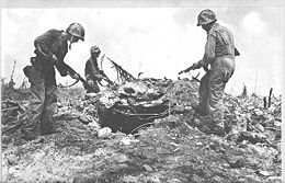
performed an amphibious assault on Kwajalein. Following the battle 1st Battalion, 111th Infantry regiment remained as a garrison force while the remainder of the regiment went elsewhere. On February 1, 1944, Kwajalein was the target of the most concentrated bombardment of the Pacific War
Pacific War
The Pacific War, also sometimes called the Asia-Pacific War refers broadly to the parts of World War II that took place in the Pacific Ocean, its islands, and in East Asia, then called the Far East...
. Thirty-six thousand shells from naval ships and ground artillery on a nearby islet struck Kwajalein. American B-24 Liberator bombers
B-24 Liberator
The Consolidated B-24 Liberator was an American heavy bomber, designed by Consolidated Aircraft of San Diego, California. It was known within the company as the Model 32, and a small number of early models were sold under the name LB-30, for Land Bomber...
aerially bombarded the island, adding to the destruction.
Of the 8,782 Japanese personnel deployed to the atoll (including Korean laborers), it has been argued that only 2,200 were combat trained. Despite this likelihood, Japanese resistance was strong and resilient, even given the fact that Japanese troops were outnumbered by tens of thousands of American troops. By the end of the battle, 373 Americans were killed, 7,870 "Japanese" were killed, and an estimated 200 Marshallese were killed. U.S. military documents do not discriminate the Japanese from Korean dead; however, the Korean Government's Truth Commission for Forced Labor Under Japanese Imperialism reports an official figure from the Japanese government of 310 Koreans killed in the American invasion of Kwajalein. Whether this figure represents Kwajalein islet or the whole atoll is unclear.
Kwajalein was one of the few locations in the Pacific war where Islanders were killed while actually fighting for the Japanese. They were not all fighting for the same reasons.
Since no distinction was made between dead Japanese soldiers and Korean laborers, both are enshrined as war hero guardian spirits for the Japanese nation in Yasukuni Shrine. This suggests that these Koreans died for the sake of Japan. In fact, they were forced laborers. None of the Marshall Islanders who died for Japan are enshrined.
On February 6, 1944, Kwajalein was claimed by the United States and was taken, with the rest of the Marshall Islands, eventually as a Trust Territory of the United States, a move which was often referred to as "liberation," despite widespread ambivalence among Islanders.
As a result of the battle, the lagoon contains wrecks of mostly Japanese ships and a few planes.
Roi-Namur used to be 4 separate islands: Roi, Namur, Enedrikdrik (Ane-dikdik), and Kottepina. The pass between the islands was filled in using sand that was dredged from the lagoon by both Korean laborers working for the Japanese and Americans between 1940 and 1945, and after the war the resulting conjoined islands were renamed Roi-Namur.
Trust Territory under the United Nations
Although there is a misconception in some local historical narratives that Kwajalein Atoll was "taken back" by the United States (see for instance many of the archived diaries written by invading Marines, as well as pamphlets produced by the United States Kwajalein Atoll's "Hourglass" newspaper and civilian contractors, like Bell Telephone Laboratories in the 1970s), the Marshall Islands had never been a United States territory prior to the initiation of the U.S. Trust Territory of the Pacific Islands that followed World War II. In fact, at first Marshall Islanders were treated by the United States as Japanese subjects, and this made perfect sense, since although many who had experienced hardship under the military were eager to welcome the Americans, most Marshallese at the time had been educated in Japanese schools, mixed Japanese and Marshallese customs in their day-to-day lives, spoke Japanese, and even had Japanese ancestry. Some were even applying for full Japanese citizenship at the time of the U.S. Invasion, and, as Higuchi Wakako has argued, they were likely to have it granted by the Japanese government. However, an ambiguous clause in the League of Nations Mandate made it possible for the United States to treat Marshallese as "liberated persons under American wardship." The peculiar contradiction of being "liberated into wardship" foreshadowed the coming decades of ambivalent dependence on the United States throughout the Trust Territory period and thereafter.Archived documents and photographs at the U.S. National Archives make it clear that American forces waged a campaign to ensure that all pro-Japanese sentiment amongst Marshallese was eradicated. In recent years, however, elderly Marshallese and other Micronesians have been much more outspoken about their nostalgia for Japanese times and some of their positive regard for the pre-militarized lifestyle in the Marshalls under Japanese rule.
Evolution into a U.S. military installation
In the years following the American invasion of early 1944, Kwajalein Atoll was swiftly converted not only into a staging area for further campaigns in the advance on the Japanese homeland in the Pacific WarPacific War
The Pacific War, also sometimes called the Asia-Pacific War refers broadly to the parts of World War II that took place in the Pacific Ocean, its islands, and in East Asia, then called the Far East...
, but the United States also used it as a main command center and preparation base for Operation Crossroads
Operation Crossroads
Operation Crossroads was a series of nuclear weapon tests conducted by the United States at Bikini Atoll in mid-1946. It was the first test of a nuclear weapon after the Trinity nuclear test in July 1945...
and an extensive series of nuclear tests (comprising a total of 67 blasts) at the Marshalls atolls of Bikini and Enewetak.
Since 1944, when American forces captured the atoll from the Japan
Japan
Japan is an island nation in East Asia. Located in the Pacific Ocean, it lies to the east of the Sea of Japan, China, North Korea, South Korea and Russia, stretching from the Sea of Okhotsk in the north to the East China Sea and Taiwan in the south...
ese in the Battle of Kwajalein
Battle of Kwajalein
The Battle of Kwajalein was a battle of the Pacific campaign of World War II, fought from 31 January-3 February 1944, on Kwajalein Atoll in the Marshall Islands. Employing the hard-learned lessons of the battle of Tarawa, the United States launched a successful twin assault on the main islands of...
, it has been used for military purposes by the U.S.
United States
The United States of America is a federal constitutional republic comprising fifty states and a federal district...
. It was the main support site for the weapons-testing program, Operation Crossroads
Operation Crossroads
Operation Crossroads was a series of nuclear weapon tests conducted by the United States at Bikini Atoll in mid-1946. It was the first test of a nuclear weapon after the Trinity nuclear test in July 1945...
.
The German heavy cruiser Prinz Eugen
German cruiser Prinz Eugen
Prinz Eugen was an Admiral Hipper-class heavy cruiser, the third member of the class of five vessels. She served with the German Kriegsmarine during World War II. The ship was laid down in April 1936 and launched August 1938; Prinz Eugen entered service after the outbreak of war, in August 1940...
was towed to Kwajalein from Bikini Atoll after the Operation Crossroads
Operation Crossroads
Operation Crossroads was a series of nuclear weapon tests conducted by the United States at Bikini Atoll in mid-1946. It was the first test of a nuclear weapon after the Trinity nuclear test in July 1945...
nuclear tests in 1946. It developed a leak, was towed out and sank in the lagoon.
By the 1950s, the Marshallese population coming to work at the base at Kwajalein had grown, and the conditions in the makeshift labor camp on Kwajalein islet were such that the U.S. Navy administering the atoll at the time decided to relocate these Islanders to nearby Ebeye, an islet only three islands to the north of Kwajalein and accessible by a short boat ride or walk over the reef at low tide. Nuclear refugees from the atolls irradiated by the American tests were also moved to Ebeye, and in 1964, when the United States initiated its Anti-ballistic missile
Anti-ballistic missile
An anti-ballistic missile is a missile designed to counter ballistic missiles .A ballistic missile is used to deliver nuclear, chemical, biological or conventional warheads in a ballistic flight trajectory. The term "anti-ballistic missile" describes any antimissile system designed to counter...
testing program with the Nike-Zeus program in Kwajalein Atoll, authorities moved also the remaining Marshall Islanders who lived scattered on their land throughout the atoll to the small shantytown of Ebeye which had been erected with plywood housing by American contractors. This relocation from the Mid-Atoll Corridor would eventually precipitate into the numerous landowner resistance movements by the people of Kwajalein Atoll, who deeply resented the continuing American occupation without their consent and without proper compensation.
With the end of the Cold War
Cold War
The Cold War was the continuing state from roughly 1946 to 1991 of political conflict, military tension, proxy wars, and economic competition between the Communist World—primarily the Soviet Union and its satellite states and allies—and the powers of the Western world, primarily the United States...
and a decreased threat of nuclear attack, many defense programs were canceled in the early 1990s. However, overcrowding on Ebeye remains a major problem, and continuing military operations and various launch or re-entry tests perpetuate the dislocation of Marshall Islanders from their small islands throughout Kwajalein Atoll. The United States Army Kwajalein Atoll test site does not provide logistical support to Ebeye or Ennibur islets.
21st century
In 2008, a new government was voted into power in the Republic of the Marshall Islands, with Litokwa TomeingLitokwa Tomeing
Iroij Litokwa Tomeing was the President of the Marshall Islands from January 2008 until October 2009.-Early and personal life:Litokwa Tomeing was born on Wotje Atoll, in the Japanese administered Marshall Islands, on October 14, 1939...
as President and Tony deBrum as foreign minister. This new government was sympathetic to the needs of the Ebeye community and the Kwajalein landowners, partly because it is a coalition government formed in part from the Aelon Kein Ad Party (formerly known as the Kabua Party), which represents Kwajalein landowners and is led by Paramount Chief (Iroijlaplap
Iroijlaplap
Iroijlaplap is the title given to the paramount chiefs in the Marshall Islands. An ordinary chief holds the title of Iroij ....
) Imata Kabua
Imata Kabua
Imata Kabua was President of the Marshall Islands from 14 January 1997 to 10 January 2000. He became the Iroijlaplap of Kwajalein after the death of Amata Kabua.-References:* . Rulers.org. Accessed 2011-02-01....
. This new government is actively pursuing a more productive and mutually beneficial agreement regarding the Kwajalein Atoll Land Use Agreement with the United States.
With the election of Barack Obama
Barack Obama
Barack Hussein Obama II is the 44th and current President of the United States. He is the first African American to hold the office. Obama previously served as a United States Senator from Illinois, from January 2005 until he resigned following his victory in the 2008 presidential election.Born in...
to the Presidency of the United States, the new administration of the Marshall Islands, and the looming deadline for signing the Land Use Agreement (LUA), at the end of 2008, President Litokwa Tomeing wrote a letter to George W. Bush
George W. Bush
George Walker Bush is an American politician who served as the 43rd President of the United States, from 2001 to 2009. Before that, he was the 46th Governor of Texas, having served from 1995 to 2000....
asking that the deadline for the LUA be lifted. Within a day of the expiration of this LUA deadline, the United States agreed to shift this deadline back another five years, but it reiterated its stance that the Compact renegotiation was already completed and that it expected the Republic of the Marshall Islands to abide by the MUORA it agreed to in 2003. Government leaders and landowners are hopeful, however, that this extension will allow for more money to be paid to the land owners.
The U.S. Army Kwajalein Atoll (USAKA) installation has been downsizing, in part because of budget constraints and technological improvements (such as a new trans-oceanic fiber-optic cable) that will allow the testing range to be operated extensively from sites in the United States, thus minimizing operation costs and the need for on-site workers or residents. Recently, the American population of the Kwajalein installation has dropped dramatically, and the aluminum-sided trailers that once housed the bulk of the contractor population are systematically being removed from the main island. Nevertheless, the enormous investment in these new technologies and recent statements by Army leadership indicate that the United States is committed to remaining in the Marshall Islands at Kwajalein Atoll for the foreseeable future.
Kwajalein largely supported a vote of no confidence for President Tomeing in April 2009. Subsequently, outgoing American ambassador Clyde Bishop
Clyde Bishop
Dr. Clyde Bishop is an American diplomat and incumbent U.S. Ambassador to the Marshall Islands. He is a member of the U.S. Senior Foreign Service and is class of Minister Counselor.-Biography & Career:...
commented in late April 2009 that future funding to the entire Republic of the Marshall Islands was dependent on the use of Kwajalein. This strong wording seems to imply that without being allowed to use Kwajalein under the terms that the U.S. specified in its original 2003 Compact of Free Association revision, the U.S. may withhold its promised funding to the entire nation.
Kwajalein atoll has been leased by the United States for missile testing and various other operations from well-prior to independence for the Marshall Islands. Although this military history has influenced the lives of the Marshall Islanders who have lived in the atoll through the war to the present, the military history of Kwajalein has prevented tourism and has kept the environment in relatively pristine condition. American civilians and their families who reside at the military installations in Kwajalein are able to utilize this environment with few restrictions.
Current use by U.S. military
Testing sites
Eleven of the 97 islands are leased by the United States and are part of the Ronald Reagan Ballistic Missile Defense Test SiteRonald Reagan Ballistic Missile Defense Test Site
The Ronald Reagan Ballistic Missile Defense Test Site, commonly referred to as the Reagan Test Site , is a missile test range in the Pacific Ocean. It covers about and includes rocket launch sites at the Kwajalein Atoll , Wake Island, and Aur Atoll. It primarily functions as a test facility for U.S...
(RTS), formerly known as Kwajalein Missile Range. RTS includes radar installations, optics, telemetry, and communications equipment, which are used for ballistic missile and missile-interceptor testing and space operations support.
Kwajalein has one of five ground stations used in controlling the range that assist in the operation of the Global Positioning System
Global Positioning System
The Global Positioning System is a space-based global navigation satellite system that provides location and time information in all weather, anywhere on or near the Earth, where there is an unobstructed line of sight to four or more GPS satellites...
(GPS) navigational system.
SpaceX
SpaceXSpaceX
Space Exploration Technologies Corporation, or more popularly and informally known as SpaceX, is an American space transport company that operates out of Hawthorne, California...
updated facilities on Omelek Island
Omelek Island
Omelek Island is part of the Kwajalein Atoll in the Republic of the Marshall Islands. It is controlled by the United States military under a long-term lease and is part of the Ronald Reagan Ballistic Missile Defense Test Site.-Geography:The Island is about in size...
to launch its commercial Falcon 1
Falcon 1
The Falcon 1 is a partially reusable launch system designed and manufactured by SpaceX, a space transportation company in Hawthorne, California. The two-stage-to-orbit rocket uses LOX/RP-1 for both stages, the first powered by a single Merlin engine and the second powered by a single Kestrel engine...
rockets. The first successful Falcon 1 space launch from Omelek was conducted in 2008.
It can launch polar and geosynchronous Falcon 9s from Omelek.
Wartime memorials
A ceremony is held at Japan's Yasukuni Shrine
Yasukuni Shrine
is a Shinto shrine located in Chiyoda, Tokyo, Japan. It is dedicated to the soldiers and others who died fighting on behalf of the Emperor of Japan. Currently, its Symbolic Registry of Divinities lists the names of over 2,466,000 enshrined men and women whose lives were dedicated to the service of...
annually in April (originally held in February to coincide with the anniversary of the battle), where the memories of the Japanese soldiers are honored and surviving families offer prayers to their spirits. Small groups of bereaved Japanese families also have made pilgrimages to Kwajalein on a semi-annual basis since the 1990s, the first of these groups being the Japan Marshall Islands War-Bereaved Families Association, which negotiated its visit with the U.S. Army as far back as 1964 and made its first visit in 1975 at the invitation of the Kwajalein Missile Range. The bereaved families of conscripted Korean laborers have also recently traveled in groups to the Marshall Islands and other parts of Micronesia, the Philippines, and Indonesia, with funding from the Japanese government, although they have not yet paid a group visit to Kwajalein.
Recreation
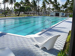
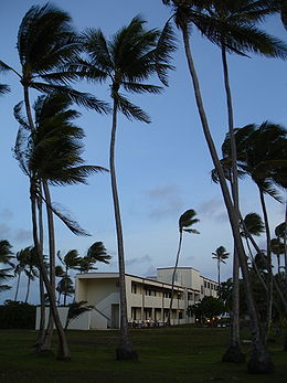
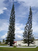
While Kwajalein has several beaches, only Emon Beach on the northwest, lagoon side of the island features a formal swimming area with lifeguards.
Kwajalein's main recreation is bicycles. Because personal vehicles are not allowed on Kwajalein, bicycles are used by most inhabitants to get around.
Economy
On Kwajalein Island, housing is free for most personnel, depending on contract or tour of duty.Land lease disputes
Under the constitution of the Republic of the Marshall IslandsMarshall Islands
The Republic of the Marshall Islands , , is a Micronesian nation of atolls and islands in the middle of the Pacific Ocean, just west of the International Date Line and just north of the Equator. As of July 2011 the population was 67,182...
the government can only own land under limited circumstances. Practically, all land is private and inherited through one's matriline
Matrilineality
Matrilineality is a system in which descent is traced through the mother and maternal ancestors. Matrilineality is also a societal system in which one belongs to one's matriline or mother's lineage, which can involve the inheritance of property and/or titles.A matriline is a line of descent from a...
and clan. Since the United States began leasing land, the issue of proper land payments has been a major issue of contention for landowners which continues today. "Landowners" here refers to the consortium of irooj (chiefs), alaps (clan heads) and rijerbal (workers) who have land rights to the places used for military purposes by the United States. In the case of Kwajalein Atoll in particular, a "senior rijerbal" is also assigned a role to represent families who have claims to land as "workers" of that location.
Unclear and insufficient in the opinion of these landowners, the original lease arrangements for Kwajalein Atoll with the U.S. were finally negotiated only after the landowners and their supporters demonstrated in the early 1980s with a peaceful protest called "Operation Homecoming," in which Islanders re-inhabited their land at Kwajalein, Roi-Namur, and other restricted sites in the atoll. Although Operation Homecoming did not achieve the level of recognition for all people with land title at Kwajalein, nor an amount of compensation that truly remunerated these families for the natural resources and lands they had lost through displacement, the resulting agreements at least set a precedent for future dealings with the United States government. One of these early agreements was the first official Military Use and Operating Rights Agreement (MUORA) between the United States Army and Government of the RMI, which was linked to the Status of Forces Agreement
Status of Forces Agreement
A status of forces agreement is an agreement between a host country and a foreign nation stationing forces in that country. SOFAs are often included, along with other types of military agreements, as part of a comprehensive security arrangement...
(SOFA) that was written into the larger Compact of Free Association
Compact of Free Association
The Compact of Free Association defines the relationship that three sovereign states—the Federated States of Micronesia , the Republic of the Marshall Islands and the Republic of Palau—have entered into as associated states with the United States.Now sovereign nations, the three freely associated...
with the United States. Article 3 of the MUORA obligated the RMI to lease specific sites from their owners through a Land Use Agreement (LUA) and then sub-lease them to the United States. Effectively, this rendered the land negotiations for use of Kwajalein Atoll a "domestic issue" between the national Marshallese government in Majuro and local "landowners," even though Kwajalein, where the local Marshallese population deals on a daily basis with American military activity, is a considerable distance from Majuro. Many Kwajalein Atoll residents have complained in the past that Majuro is out of touch with the realities of Kwajalein Marshallese, and downplays their suffering while profiting from the income provided by the testing site.
The first MUORA guaranteed total payments of roughly USD
United States dollar
The United States dollar , also referred to as the American dollar, is the official currency of the United States of America. It is divided into 100 smaller units called cents or pennies....
$11 million to the landowners through the year 2016, the majority of which went, via the provisions of the LUA to the irooj (chiefs), who had the largest stake in the land. Some American and Marshallese observers claimed that these land payments were "misused." However, the recipients of these funds strongly maintain that these have always been "rental" payments (like a tenant pays to a landlord) that landowners could use at their own discretion, separate from whatever funds the U.S. earmarked to help develop or improve Kwajalein Atoll, which were funneled into the now-defunct Kwajalein Atoll Development Authority (KADA.)
In advance of its expiration in 2016, this LUA was renegotiated in 2003 as part of the Compact of Free Association, with the U.S. agreeing to pay the landowners (via the Republic of the Marshall Islands) $15 million a year, adjusted for inflation. In exchange for these payments, the Compact stipulated a new MUORA that gave America the option to use Kwajalein through 2066, renewable through 2086. The landowners, affiliated under the Kwajalein Negotiations Committee (KNC), were very unhappy with the proposed LUA, since they believed they should have been receiving at least double that amount in funds, and that more importantly the LUA did nothing to provide for Marshall Islanders' welfare, health care, safety, and rapidly increasing population on Ebeye. By their independent land appraisals and calculations, the KNC had already determined that the minimum acceptable compensation they should receive for Kwajalein lands was at least $19.1 million annually, adjusted for inflation. The landowners also claimed that there were many other terms by which they wished the U.S. would abide should the lease be extended, including providing better support and infrastructure to Ebeye, improving healthcare and education, guaranteeing that the missile testing was not creating environmental hazards, and providing a comprehensive life and property insurance policy. Despite a consensus among the landowners to refuse to allow the Compact to be signed with this inadequate LUA proposed by the U.S., the new Compact (and the MUORA, by extension) was finalized by officials of the RMI National government and went into effect in 2003.
Stating that they had not been consulted about this agreement, the landowners went on to protest this agreement, and mounted an organized boycott of the new LUA. Although the new Compact
Treaty
A treaty is an express agreement under international law entered into by actors in international law, namely sovereign states and international organizations. A treaty may also be known as an agreement, protocol, covenant, convention or exchange of letters, among other terms...
and its component MUORA was ratified in 2003, they have since held out and refused to sign the LUA of 2003, insisting, through Kwajalein Atoll elected representatives, that either a new LUA should be drafted that considers their needs or the U.S. will have to leave Kwajalein when the active LUA (which began in the 1980s) expires in 2016.
The U.S., however, considers the Compact to be an "internationally binding" agreement that has been concluded, and it thus pays an annual $15 million to the landowners, as agreed provisionally in the MUORA laid out in the 2003 Compact renegotiation; however, as this new LUA has not been signed, the difference of roughly $4 million has been going into an escrow account. The Compact made it clear that if the Republic of the Marshall Islands and the landowners did not reach an agreement about land payments by the end of 2008, these funds in escrow would be returned to the U.S. Treasury. But in resistance to this "carrot" dangled in front of the noses of the people of Kwajalein, Tony deBrum, in his former role as Kwajalein Senator, stated that it would be "insane" for Marshallese people to put up with another 70 years of the kind of circumstances that exist today in Kwajalein Atoll at Ebeye and other islands.
Infrastructure
There are two airbases and three airstrips on Kwajalein Atoll:- Bucholz Army AirfieldBucholz Army AirfieldBucholz Army Airfield is a United States Army airfield located on Kwajalein Island, Kwajalein Atoll, Marshall Islands. Its position is ideal for refueling during trans-Pacific flights, and the airport is available to civilians through Air Marshall Islands and Continental Airlines, and formerly...
to the south at Kwajalein: 08°43′12"N 167°43′54"E - Dyess Army AirfieldFreeflight International Airport (Marshall Islands)Freeflight International Airport, also known as Dyess Army Airfield, is a military airbase at Roi-Namur on Kwajalein Atoll, Marshall Islands. It is owned by the United States Army...
to the north at Roi-Namur: 09°23′49"N 167°28′15"E - Ebadon Airstrip to the west at Ebadon: 09°19′50"N 166°49′09"E
- Mejato Airstrip on Mejato: 09°19′09"N 166°50′54"E
- Meck Island Airstrip, an eastern island, between Roi-Namur and Kwajalein: 09°00′00"N 167°43′37.8"E
Since 1961, several tests of anti-ballistic missiles were conducted on Kwajalein. Therefore, there are launchpads on Illeginni Island ( 9.0000°N 167.7000°E), Roi-Namur Island ( 9.4012°N 167.4663°E) and Kwajalein Drop Zone, Pacific Ocean ( 7.6500°N 167.7000°E).
On Kwajalein Island the primary mode of personal transportation is the bicycle.
See also
- National Missile DefenseNational Missile DefenseNational missile defense is a generic term for a type of missile defense intended to shield an entire country against incoming missiles, such as intercontinental ballistic missile or other ballistic missiles. Interception might be by anti-ballistic missiles or directed-energy weapons such as lasers...
- United States Army Space and Missile Defense CommandUnited States Army Space and Missile Defense CommandThe United States Army Space and Missile Defense Command is a specialized major command within the United States Army. The command was established in 1997...
- Ground-Based Midcourse DefenseGround-Based Midcourse DefenseGround-Based Midcourse Defense is the United States system for intercepting incoming warheads in space. Currently, it is a major component of the U.S. national missile defense strategy aimed against ballistic missiles, including intercontinental ballistic missiles...
- Missile Defense AgencyMissile Defense AgencyThe Missile Defense Agency is the section of the United States government's Department of Defense responsible for developing a layered defense against ballistic missiles. The agency has its origins in the Strategic Defense Initiative, which was established in 1983 and was headed by Lt...
- Ronald Reagan Ballistic Missile Defense Test SiteRonald Reagan Ballistic Missile Defense Test SiteThe Ronald Reagan Ballistic Missile Defense Test Site, commonly referred to as the Reagan Test Site , is a missile test range in the Pacific Ocean. It covers about and includes rocket launch sites at the Kwajalein Atoll , Wake Island, and Aur Atoll. It primarily functions as a test facility for U.S...
- Marshall IslandsMarshall IslandsThe Republic of the Marshall Islands , , is a Micronesian nation of atolls and islands in the middle of the Pacific Ocean, just west of the International Date Line and just north of the Equator. As of July 2011 the population was 67,182...
- Battle of KwajaleinBattle of KwajaleinThe Battle of Kwajalein was a battle of the Pacific campaign of World War II, fought from 31 January-3 February 1944, on Kwajalein Atoll in the Marshall Islands. Employing the hard-learned lessons of the battle of Tarawa, the United States launched a successful twin assault on the main islands of...
- USS Kwajalein (CVE-98)USS Kwajalein (CVE-98)USS Kwajalein , formerly Bucareli Bay, was a Casablanca class escort carrier of the United States Navy.It was launched on 4 May 1944, by the Kaiser Co., Inc., Vancouver, Washington, under a Maritime Commission contract; sponsored by Mrs. Rudolf L. Johnson; acquired by the Navy on 7 June 1944, and...
- Communications in the Marshall IslandsCommunications in the Marshall IslandsThis article is about communications systems in the Marshall Islands.In 2010, the Majuro and Kwajalein Atoll were connected to the Internet using the HANTRU-1 undersea cable to provide high-speed bandwidth...
- History of the Marshall IslandsHistory of the Marshall IslandsEvidence suggests that around 3,000 years ago successive waves of human migrants from Southeast Asia spread across the Western Pacific populating its many small islands. The Marshall Islands were settled by Micronesians in the 2nd millennium BC. Little is known of the islands' early history...
- Geography of the Marshall IslandsGeography of the Marshall IslandsThe Marshalls consist of 29 atolls and five isolated islands, which form two parallel groups--the "Ratak" chain and the "Ralik" chain. The Marshalls share maritime boundaries with Micronesia and Kiribati. Two-thirds of the nation's population lives in Majuro and Ebeye...
About the Marshall Islands and current events
- Yokwe Online, the largest Marshallese web presence online
- Embassy of the Republic of the Marshall Islands
Transportation
History
Work on Kwajalein
- U.S. Army Space & Missile Defense Command, Reagan Test Site
- work performed at Reagan Test Site
- Bechtel summary of Kwajalein
- Kwajalein Range Services overview and job opportunities