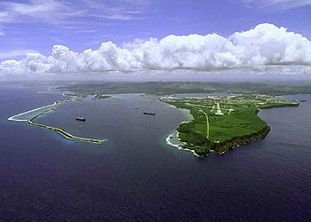
Apra Harbor
Encyclopedia

Mariana Islands
The Mariana Islands are an arc-shaped archipelago made up by the summits of 15 volcanic mountains in the north-western Pacific Ocean between the 12th and 21st parallels north and along the 145th meridian east...
. The harbor
Harbor
A harbor or harbour , or haven, is a place where ships, boats, and barges can seek shelter from stormy weather, or else are stored for future use. Harbors can be natural or artificial...
is formed by Orote Peninsula
Orote Peninsula
The Orote Peninsula is a four kilometre-long peninsula jutting from the west coast of Guam. It forms the southern coast of Apra Harbor, and its westernmost tip, Point Udall, is also Guam's westernmost point...
in the south and Cabras Island
Cabras Island
Cabras Island is a long finger of low-lying reef and land which forms the northern shore of Apra Harbor, Guam.The island's length has been extended artificially by the Glass Breakwater, named for Captain Glass, who took Guam for the United States in 1898...
in the north. To the south, the harbor narrows and then widens again to form an inner harbor. The southern end of the harbor is the location of Naval Base Guam. The northern end is the commercial port, which handles about 2 million tons of cargo
Cargo
Cargo is goods or produce transported, generally for commercial gain, by ship, aircraft, train, van or truck. In modern times, containers are used in most intermodal long-haul cargo transport.-Marine:...
a year.

