

Typhoon Nalgae (2011)
Encyclopedia
Typhoon Nalgae was a powerful tropical cyclone that struck the Philippines
, and it affected Hainan
, China
as a weak tropical storm. Nalgae was the eighth typhoon and the fourth super typhoon in 2011
.
. The low slowly drifted west until late on September 26, when the Japan Meteorological Agency (JMA) upgraded the low to a tropical depression. The low continued to drift west and the Joint Typhoon Warning Center (JTWC) issued a Tropical Cyclone Formation Alert on the system. On the morning of September 27, the JTWC reported that the low developed a quickly consolidating low level circulation center (LLCC) and initiated advisories on the system, designating it with 22W. On that evening, the JMA further upgraded the tropical depression to a tropical storm and named it Nalgae. The storm slowly drifted to the west and kept on intensifying gradually. Nalgae developed a microwave eye like feature and well defined convective banding in all the quadrants. The system had a tiny radius of winds, though it was still strengthening significantly and was very well defined. On the evening of September 28, the JMA reported that Nalgae continued to intensify, as they upgraded it to a severe tropical storm with winds of over 55 knots (29.9 m/s). On that night, the PAGASA initiated advisories on Nalgae, giving it the local name Quiel, as it entered the Philippine Area of Responsibility (PAR).
On the morning of September 29, the JTWC reported that Nalgae developed a small microwave eye
like feature and multiple convective bands wrapped tightly into the center. Using the Dvorak technique
, the JTWC estimated the average 1-minute sustained wind speed of Nalgae to be at 65 knots (35.4 m/s). On that evening, the JMA further upgraded Nalgae to a typhoon. Nalgae continued to drift westwards at approximately 13 knots (7.1 m/s) and continued to intensify. On the night of September 29, Nalgae's outflow to the east got more enhanced and the outflow in all other directions remained radial. Nalgae was running west quite quickly because of a strong and a deep subtropical ridge
located to the east of the system. The JTWC anticipated Nalgae to continually strengthen before it made landfall over Luzon, Philippines. Continuing on its quick westward run, Nalgae developed a tiny 5 nautical miles (9.3 km) eye with a small break in the eyewall around the eastern periphery, because of a slight vertical wind shear as estimated by the JTWC. There was deep convective banding extending approximately 120 nautical miles (222.2 km) from the center and the overall outflow remained good. based on Dvorak intensity estimates, the winds of Nalgae were then raised to 95 knots (51.7 m/s).
were reminded by the United States government "to carry their travel documents at all times and secure them in a safe and waterproof location." The government launched the helpline
numbers 1-888-407-4747 and 1-202-501-4444 so that the people traveling within the nation can obtain updated information from the Department of State. Also, the PAGASA insisted all people living in the low-lying areas to leave immediately. The said that "Even areas that are currently not flooded are in danger because water from flooded communities will eventually seep into neighboring areas." As preparations were underway, the president of Philippines said that "More troops and equipment from the Army, Navy and Air Force, including helicopters, have been deployed to flooded areas in Central Luzon to search and rescue affected residents". He added that the "National Disaster Risk Reduction and Management Council has been taking all necessary precautions from early warning, pre-emptive evacuation to on-going relief and recovery operations amid the onslaught of Typhoon Pedring (Nesat) and the anticipated effects of Typhoon Quiel (Nalgae) over the weekend." The PAGASA hoisted public storm warning signal number 3 in Cagayan
and Isabela
as the storm drifted closer. They said that "The coming storm is expected to bring strong winds, but authorities are more concerned about the amount of rainfall it will pour." Fears worsened as the typhoon came 4 days after Typhoon Nesat
devastated the same place and also lead to a state of calamity being declared. Five towns in Cagayan were still flooded and the same place was to be hit by Nalgae, which is much stronger than Nesat.
of China upgraded the rainstorm alert for Typhoon Nalgae to the orange level, the second-highest alert level in the country's four-level rainstorm alert system, reporting that a number of tidal stations off the provinces of Hainan
, Guangdong
and Fujian
would experience tides beyond the ordinary safety levels. The agency asked all the tourists heading to typhoon-hit provinces to remain flexible with their itineraries as several air and ship may be either cancelled or indefinitely delayed when the typhoon comes ashore. China's flood control authority also took action by sending three emergency teams to Hainan, Guangdong and Guangxi
provinces in order to implement increased preventative measures against typhoon-based natural disasters after announcing a level IV emergency response to Nalgae. According to the agency, Nalgae, the third tropical cyclone to have affected the region in a short span of just 10 days, can bring about many problems, as strong winds and heavy rain had caused severe damage to some water projects in those regions and consumed large quantities of flood control materials. They said that when Nalgae approaches, it will be more difficult to organize disaster prevention work. Also, tourists were quickly moving in to the southern coastal areas to enjoy the week-long public holiday
.
in Isabela province
. The PAGASA weather bureau chief Graciano Yumul said that "The ground is still supersaturated and it cannot absorb more water. This will just flow down to rivers and towns, and there is a big possibility that landslides, flash flooding and flooding could occur." The search and rescue operations for Typhoon Nesat were halted because of the fierce weather brought by Nalgae. The NOLCOM chief Major General Jessie Dellosa said "Our rescue operations are ongoing with the use of watercraft and rubber boats. We are also continuously coordinating with the local government units to rescue the affected residents in Calumpit and Hagonoy." The National Disaster Risk Reduction and Management Council director Benito Ramos said that thousands of rescue workers were deployed across Luzon and the island’s sparsely populated northeast coast was evacuated following the orders from the president Benigno Aquino III
. Ramous said "We're implementing persuasive evacuation operations. If I have to handcuff people to remove them from their homes I could be charged with human rights violations." Nalgae was making a similar path across the saturated Luzon Island as Typhoon Nesat. The wind gusts brought by Nalgae toppled trees and blew away tin roofs of some houses in Isabela's provincial capital of Ilagan. Nalgae continued to worsen the flooding and destruction brought by Nesat. Nalgae was far more stronger than Nesat and plummeted the nation with more winds and rains. The governor of Isabela province, Faustino Dy said that "Hundreds of people in coastal areas had been evacuated as rain and strong cut power lines, uprooted trees and blocked roads with debris." He added that "Nalgae could cause floods on Luzon's central plains before passing through La Union province, a tobacco-growing area, and then heading off into the South China Sea." Also, the PAGASA announced that an estimated 10–18 mm per hour of rains were experienced in several areas across the nation filling up dams and causing river systems to swell. As the storm continued to move inland with strong winds, many structures including billboards, tarpaulins and wooden materials in the town of Cauayan were damaged. The barriers of the Isabela highway were also destroyed by the typhoon. The government responded quickly and cleared off all the debris on the highway and made it usable again. According to the National Disaster Risk Reduction and Management Council (NDDRMC), the onslaught of the typhoon resulted in the death of 1 person living in the Mountain Province
, a landlocked province
of the Philippines
in the Cordillera Administrative Region
in Luzon
. It was reported that Sonny Marcos, a passenger onboard a passenger van was buried alongside the Halsema Highway
, the highest altitude highway in the Philippines that stretches from Baguio City
to Bontoc, Mountain Province
. Seeing the heavy rains and flooding caused by the typhoon, Graciano Yumul then said to the people of the nation, "You can look at all the scientific computations and we can really prove that the dam openings would only contribute a maximum of 5% to the floods we see now in Pampanga and Bulacan. The water came from the run-off from the mountains, due to rains dropped by Pedring."
The Malacañang Palace
called on Filipinos, especially those in Metro Manila
to help each other whose properties have been devastated during the twin-typhoons Nesat and Nalgae, The Deputy presidential spokesperson Abigail Valte said "Relief and rescue workers need boats that can maneuver in flooded areas in Central Luzon
, and volunteers who can help repack relief goods of the Department of Social Welfare and Development. he DSWD is repacking relief goods at its warehouse near the Ninoy Aquino International Airport
. If you want to volunteer your services, you can do so. As for the wealthier Filipinos
who own rubber boats or speedboats and want to lend them to our authorities, they can get in touch with the local government officials concerned." Thousands of people were ordered to evacuate their homes after the second typhoon, Nalgae slammed into the eastern coast of central Luzon, ashore south of northeastern Palanan Bay in Isabela Province. Similar to the previous typhoon Nesat, Nalgae blew through Luzon very quickly. The typhoon took a similar path across areas on Luzon saturated by Typhoon Nesat, trapping thousands on rooftops and sent huge waves that breached a seawall in Manila Bay. Nalgae only took about six hours to blow through the Luzon island. Meanwhile, the heavy rains brought by the system soaked the Cordillera
mountain range, and water cascading from the slopes was expected to further swell tributaries and rivers in the central Luzon plains before it finally drains out into the Manila Bay
. Office of Civil Defense administrator Benito Ramos told "We are asking everyone still refusing to leave their homes to let authorities evacuate them. Water from the Cordilleras could reach the plains today and there is a possibility that there won’t be any more rooftops left to see if that catches up with water from Nesat that’s just now subsiding." As he claimed, there was a danger that the water could also run past the rooftops of every house leaving none alive. The extremely strong winds blown by Nalgae set off a rockslide in northern Bontoc provincecausing boulders to roll down a mountainside and smash on a passing van, killing one man. In the rice-growing province of Bulacan
north of Manila, several hundreds of people in several towns remained trapped on their rooftops as the floodwaters brought by Nesat never retreated and more flooding and rain was brought by Nalgae. Rescuers aboard rubber boats could not reach them because the alleyways were too narrow. Officials said that two army helicopters would be later deployed to rescue the victims.
The province of Pampanga was badly affected - mainly due to the already prevailing floods from the previous typhoon Pedring (Philippines) or Typhoon Nesat (International name)
. The floods continued till 5 October - much after the rains subsided. Boats were brought out to navigate the roads that had turned into rivers. The groudn floor of most houses remained under water up to 4 days after Quiel passed.
, a Malaysian-based low-cost airline
which is Asia
's largest low-fare, no-frills airline and a pioneer of low-cost travel in Asia said that they would provide free aid to the victims of the twin typhoons in the Philippines. They announced that they would allocate special space in their cargo on its daily Manila bound flight. They also asked people who were interested to donate for the Flippinos could contact them at their email address, airasiacares@airasia.com. Jay Mijares, a spokesman for the nonprofit humanitarian group, World Vision said that "The immediate need is ready-to-eat food and water. Survivors have no means to cook food. We are seeing a mass exodus of people looking for food, there is no supply, and on top of that their livelihood is disrupted. They have money but there's just nothing to buy." According to the disaster council NDRRMC, "Over the course of the weekend, the storm forced the closure of a number of bridges and made a number of roads impassable in the cities of Calasiao and Dagupan on Luzon island."
On October 3, Philippine authorities rushed aid to thousands of people marooned in their flooded homes for a week since Nesat and Nalgae together battered the nation. After a long time, the flood water slowly started receding and the rescue workers were able to deliver food and other relief materials to those in need. In Calumpit. one of the worst hit towns, a construction worker in line for receiving the relief materials said to a new agency, "We have no food to eat, and no clean drinking water." Although floodwaters have begun to subside, thousands of families continued to stay in the evacuation centers as more than 43,000 houses were damaged by the typhoon Nesat alone. In the Pampanga province the typhoon breached several dike
s or small channels developed for the flow of drain water. The destructive landslides brought by Nalgae cut off large portions of the philippine highways isolating the town of Carranglan in Nueva Ecija
. Also, after the water receded, most of the victims refused to leave their homes and head for the evacuation centers as they feared that their houses could be easily robbed in such a situation. They asked for food and relief materials to be delivered to their house instead. Mayor James de Jesus of the worst-hit Calumpit town located to the north of Manila said that "For now we need rescue teams with rubber boats. We need to distribute food and water to the families stranded by the floods. I cannot reach all of them personally." It was later reported that at least 8 million people living in the Philippines have experience faced much worse floods than the earlier destruction caused by typhoon Nesat. The disaster management chief Benito Ramos said "The fight is not over yet. I hope the (Nesat) floods will wash out to Manila Bay before the (Nalgae) runoff hits the area. If the latter catches up to the former, there won’t be any rooftops left to see above the floodwaters." The local weather agency announced that the water levels on the tributaries of major central Luzon rivers were still continuing to rise fast and posed a threat to the nearby towns and villages.
Philippines
The Philippines , officially known as the Republic of the Philippines , is a country in Southeast Asia in the western Pacific Ocean. To its north across the Luzon Strait lies Taiwan. West across the South China Sea sits Vietnam...
, and it affected Hainan
Hainan
Hainan is the smallest province of the People's Republic of China . Although the province comprises some two hundred islands scattered among three archipelagos off the southern coast, of its land mass is Hainan Island , from which the province takes its name...
, China
China
Chinese civilization may refer to:* China for more general discussion of the country.* Chinese culture* Greater China, the transnational community of ethnic Chinese.* History of China* Sinosphere, the area historically affected by Chinese culture...
as a weak tropical storm. Nalgae was the eighth typhoon and the fourth super typhoon in 2011
2011 Pacific typhoon season
The 2011 Pacific typhoon season was the time of the year in which tropical cyclones form in the Western Pacific Ocean. The season ran throughout 2011 with most tropical cyclones forming between May and November. The scope of this article is limited to the Pacific Ocean to the north of the equator...
.
Meteorological history
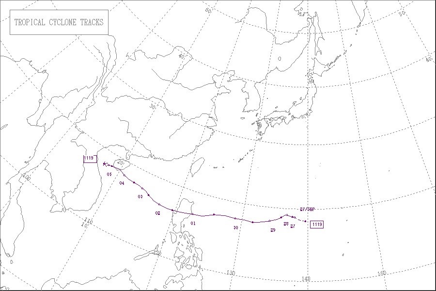
On the morning of September 24, an area of low pressure with isolated deep convection developed to the west of the Northern Mariana IslandsNorthern Mariana Islands
The Northern Mariana Islands, officially the Commonwealth of the Northern Mariana Islands , is a commonwealth in political union with the United States, occupying a strategic region of the western Pacific Ocean. It consists of 15 islands about three-quarters of the way from Hawaii to the Philippines...
. The low slowly drifted west until late on September 26, when the Japan Meteorological Agency (JMA) upgraded the low to a tropical depression. The low continued to drift west and the Joint Typhoon Warning Center (JTWC) issued a Tropical Cyclone Formation Alert on the system. On the morning of September 27, the JTWC reported that the low developed a quickly consolidating low level circulation center (LLCC) and initiated advisories on the system, designating it with 22W. On that evening, the JMA further upgraded the tropical depression to a tropical storm and named it Nalgae. The storm slowly drifted to the west and kept on intensifying gradually. Nalgae developed a microwave eye like feature and well defined convective banding in all the quadrants. The system had a tiny radius of winds, though it was still strengthening significantly and was very well defined. On the evening of September 28, the JMA reported that Nalgae continued to intensify, as they upgraded it to a severe tropical storm with winds of over 55 knots (29.9 m/s). On that night, the PAGASA initiated advisories on Nalgae, giving it the local name Quiel, as it entered the Philippine Area of Responsibility (PAR).
On the morning of September 29, the JTWC reported that Nalgae developed a small microwave eye
Eye (cyclone)
The eye is a region of mostly calm weather found at the center of strong tropical cyclones. The eye of a storm is a roughly circular area and typically 30–65 km in diameter. It is surrounded by the eyewall, a ring of towering thunderstorms where the second most severe weather of a cyclone...
like feature and multiple convective bands wrapped tightly into the center. Using the Dvorak technique
Dvorak technique
The Dvorak technique is a widely used system to subjectively estimate tropical cyclone intensity based solely on visible and infrared satellite images. Several agencies issue Dvorak intensity numbers for cyclones of sufficient intensity...
, the JTWC estimated the average 1-minute sustained wind speed of Nalgae to be at 65 knots (35.4 m/s). On that evening, the JMA further upgraded Nalgae to a typhoon. Nalgae continued to drift westwards at approximately 13 knots (7.1 m/s) and continued to intensify. On the night of September 29, Nalgae's outflow to the east got more enhanced and the outflow in all other directions remained radial. Nalgae was running west quite quickly because of a strong and a deep subtropical ridge
Subtropical ridge
The subtropical ridge is a significant belt of high pressure situated around the latitudes of 30°N in the Northern Hemisphere and 30°S in the Southern Hemisphere. It is characterized by mostly calm winds, which acts to reduce air quality under its axis by causing fog overnight, and haze during...
located to the east of the system. The JTWC anticipated Nalgae to continually strengthen before it made landfall over Luzon, Philippines. Continuing on its quick westward run, Nalgae developed a tiny 5 nautical miles (9.3 km) eye with a small break in the eyewall around the eastern periphery, because of a slight vertical wind shear as estimated by the JTWC. There was deep convective banding extending approximately 120 nautical miles (222.2 km) from the center and the overall outflow remained good. based on Dvorak intensity estimates, the winds of Nalgae were then raised to 95 knots (51.7 m/s).
Philippines
On September 30, the Americans living in PhilippinesPhilippines
The Philippines , officially known as the Republic of the Philippines , is a country in Southeast Asia in the western Pacific Ocean. To its north across the Luzon Strait lies Taiwan. West across the South China Sea sits Vietnam...
were reminded by the United States government "to carry their travel documents at all times and secure them in a safe and waterproof location." The government launched the helpline
Helpline
A helpline was originally a telephone service which offers help to those who call. Many helpline services now offer more than telephone support - offering access to information, advice or customer service via telephone, email, web or SMS....
numbers 1-888-407-4747 and 1-202-501-4444 so that the people traveling within the nation can obtain updated information from the Department of State. Also, the PAGASA insisted all people living in the low-lying areas to leave immediately. The said that "Even areas that are currently not flooded are in danger because water from flooded communities will eventually seep into neighboring areas." As preparations were underway, the president of Philippines said that "More troops and equipment from the Army, Navy and Air Force, including helicopters, have been deployed to flooded areas in Central Luzon to search and rescue affected residents". He added that the "National Disaster Risk Reduction and Management Council has been taking all necessary precautions from early warning, pre-emptive evacuation to on-going relief and recovery operations amid the onslaught of Typhoon Pedring (Nesat) and the anticipated effects of Typhoon Quiel (Nalgae) over the weekend." The PAGASA hoisted public storm warning signal number 3 in Cagayan
Cagayan
Cagayan , the "Land of Smiling Beauty", is a province of the Philippines in the Cagayan Valley region in Luzon. Its capital is Tuguegarao City and is located at the northeastern corner of the island of Luzon. Cagayan also includes the Babuyan Islands to the north. The province borders Ilocos Norte...
and Isabela
Isabela
-Places:* Isabela, Puerto Rico* Isabela Island of the Galápagos Islands* La Isabela in the Dominican Republic, first settlement of Columbus in the New World* Isabela , Philippines* Isabela City, Basilan, Philippines...
as the storm drifted closer. They said that "The coming storm is expected to bring strong winds, but authorities are more concerned about the amount of rainfall it will pour." Fears worsened as the typhoon came 4 days after Typhoon Nesat
Typhoon Nesat (2011)
Typhoon Nesat was the most powerful tropical cyclone to directly impact China since 2005. It also struck the Philippines during the 2011 Pacific typhoon season, killing 83 people...
devastated the same place and also lead to a state of calamity being declared. Five towns in Cagayan were still flooded and the same place was to be hit by Nalgae, which is much stronger than Nesat.
China
On October 3, the National Marine Environmental Forecasting CenterState Oceanic Administration
State Oceanic Administration is an administrative agency subordinate to the Ministry of Land and Resources, responsible for the supervision and management of sea area in the People's Republic of China and coastal environmental protection, protecting national maritime rights and organizing...
of China upgraded the rainstorm alert for Typhoon Nalgae to the orange level, the second-highest alert level in the country's four-level rainstorm alert system, reporting that a number of tidal stations off the provinces of Hainan
Hainan
Hainan is the smallest province of the People's Republic of China . Although the province comprises some two hundred islands scattered among three archipelagos off the southern coast, of its land mass is Hainan Island , from which the province takes its name...
, Guangdong
Guangdong
Guangdong is a province on the South China Sea coast of the People's Republic of China. The province was previously often written with the alternative English name Kwangtung Province...
and Fujian
Fujian
' , formerly romanised as Fukien or Huguing or Foukien, is a province on the southeast coast of mainland China. Fujian is bordered by Zhejiang to the north, Jiangxi to the west, and Guangdong to the south. Taiwan lies to the east, across the Taiwan Strait...
would experience tides beyond the ordinary safety levels. The agency asked all the tourists heading to typhoon-hit provinces to remain flexible with their itineraries as several air and ship may be either cancelled or indefinitely delayed when the typhoon comes ashore. China's flood control authority also took action by sending three emergency teams to Hainan, Guangdong and Guangxi
Guangxi
Guangxi, formerly romanized Kwangsi, is a province of southern China along its border with Vietnam. In 1958, it became the Guangxi Zhuang Autonomous Region of the People's Republic of China, a region with special privileges created specifically for the Zhuang people.Guangxi's location, in...
provinces in order to implement increased preventative measures against typhoon-based natural disasters after announcing a level IV emergency response to Nalgae. According to the agency, Nalgae, the third tropical cyclone to have affected the region in a short span of just 10 days, can bring about many problems, as strong winds and heavy rain had caused severe damage to some water projects in those regions and consumed large quantities of flood control materials. They said that when Nalgae approaches, it will be more difficult to organize disaster prevention work. Also, tourists were quickly moving in to the southern coastal areas to enjoy the week-long public holiday
National Day of the People's Republic of China
The National Day of the People's Republic of China is celebrated every year on October 1. It is a public holiday in the People's Republic of China to celebrate their national day.The PRC was founded on October 1, 1949 with a ceremony at Tiananmen Square...
.
Philippines
Nalgae, the second typhoon hit Philippines within one week made landfall along the coast of Dinapigue townDinapigue, Isabela
Dinapigue is a 4th class municipality in the province of Isabela, Philippines. According to the latest census, it has a population of 4,807 people in 635 households. It is also called Dinapigui.-Barangays:...
in Isabela province
Isabela province
Isabela is the second largest province of the Philippines next to Palawan. It is located in the Cagayan Valley Region in Luzon. Its capital is Ilagan and borders, clockwise from the south, Aurora, Quirino, Nueva Vizcaya, Ifugao, Mountain Province, Kalinga, and Cagayan...
. The PAGASA weather bureau chief Graciano Yumul said that "The ground is still supersaturated and it cannot absorb more water. This will just flow down to rivers and towns, and there is a big possibility that landslides, flash flooding and flooding could occur." The search and rescue operations for Typhoon Nesat were halted because of the fierce weather brought by Nalgae. The NOLCOM chief Major General Jessie Dellosa said "Our rescue operations are ongoing with the use of watercraft and rubber boats. We are also continuously coordinating with the local government units to rescue the affected residents in Calumpit and Hagonoy." The National Disaster Risk Reduction and Management Council director Benito Ramos said that thousands of rescue workers were deployed across Luzon and the island’s sparsely populated northeast coast was evacuated following the orders from the president Benigno Aquino III
Benigno Aquino III
Benigno Simeon Cojuangco Aquino III , also known as Noynoy Aquino or PNoy, is a Filipino politician who has been the 15th and current President of the Philippines since June 2010....
. Ramous said "We're implementing persuasive evacuation operations. If I have to handcuff people to remove them from their homes I could be charged with human rights violations." Nalgae was making a similar path across the saturated Luzon Island as Typhoon Nesat. The wind gusts brought by Nalgae toppled trees and blew away tin roofs of some houses in Isabela's provincial capital of Ilagan. Nalgae continued to worsen the flooding and destruction brought by Nesat. Nalgae was far more stronger than Nesat and plummeted the nation with more winds and rains. The governor of Isabela province, Faustino Dy said that "Hundreds of people in coastal areas had been evacuated as rain and strong cut power lines, uprooted trees and blocked roads with debris." He added that "Nalgae could cause floods on Luzon's central plains before passing through La Union province, a tobacco-growing area, and then heading off into the South China Sea." Also, the PAGASA announced that an estimated 10–18 mm per hour of rains were experienced in several areas across the nation filling up dams and causing river systems to swell. As the storm continued to move inland with strong winds, many structures including billboards, tarpaulins and wooden materials in the town of Cauayan were damaged. The barriers of the Isabela highway were also destroyed by the typhoon. The government responded quickly and cleared off all the debris on the highway and made it usable again. According to the National Disaster Risk Reduction and Management Council (NDDRMC), the onslaught of the typhoon resulted in the death of 1 person living in the Mountain Province
Mountain Province
Mountain Province is a landlocked province of the Philippines in the Cordillera Administrative Region in Luzon. Its capital is Bontoc and borders, clockwise from the south, Ifugao, Benguet, Ilocos Sur, Abra, Kalinga, and Isabela.Mountain Province is sometimes incorrectly named Mountain in some...
, a landlocked province
Provinces of the Philippines
The Provinces of the Philippines are the primary political and administrative divisions of the Philippines. There are 80 provinces at present, further subdivided into component cities and municipalities. The National Capital Region, as well as independent cities, are autonomous from any provincial...
of the Philippines
Philippines
The Philippines , officially known as the Republic of the Philippines , is a country in Southeast Asia in the western Pacific Ocean. To its north across the Luzon Strait lies Taiwan. West across the South China Sea sits Vietnam...
in the Cordillera Administrative Region
Cordillera Administrative Region
The Cordillera Administrative Region is a region in the Philippines composed of the provinces of Abra, Apayao, Benguet, Ifugao, Kalinga and Mountain Province, as well as Baguio City, the regional center. The Cordillera Administrative Region encompasses most of the areas within the Cordillera...
in Luzon
Luzon
Luzon is the largest island in the Philippines. It is located in the northernmost region of the archipelago, and is also the name for one of the three primary island groups in the country centered on the Island of Luzon...
. It was reported that Sonny Marcos, a passenger onboard a passenger van was buried alongside the Halsema Highway
Halsema Highway
Halsema Highway is a 2- to 4-lane highway that stretches from Baguio City to Bontoc, Mountain Province. It is the highest altitude highway in the Philippines....
, the highest altitude highway in the Philippines that stretches from Baguio City
Baguio City
The City of Baguio is a highly urbanized city in northern Luzon in the Philippines. Baguio City was established by Americans in 1900 at the site of an Ibaloi village known as Kafagway...
to Bontoc, Mountain Province
Bontoc, Mountain Province
Bontoc is a 3rd class municipality in the province of Mountain Province, Philippines. It is the capital municipality of Mountain Province. According to the latest census, it has a population of 24,798 people in 5,035 households....
. Seeing the heavy rains and flooding caused by the typhoon, Graciano Yumul then said to the people of the nation, "You can look at all the scientific computations and we can really prove that the dam openings would only contribute a maximum of 5% to the floods we see now in Pampanga and Bulacan. The water came from the run-off from the mountains, due to rains dropped by Pedring."
The Malacañang Palace
Malacañang Palace
The Malacañan Palace, commonly known simply as Malacañang, is the official residence and principal workplace of the President of the Philippines. Located at 1000 J. P. Laurel Street, San Miguel, Manila, the house was built in 1750 in Spanish Colonial style. It has been the residence of every...
called on Filipinos, especially those in Metro Manila
Metro Manila
Metropolitan Manila , the National Capital Region , or simply Metro Manila, is the metropolitan region encompassing the City of Manila and its surrounding areas in the Philippines...
to help each other whose properties have been devastated during the twin-typhoons Nesat and Nalgae, The Deputy presidential spokesperson Abigail Valte said "Relief and rescue workers need boats that can maneuver in flooded areas in Central Luzon
Central Luzon
Central Luzon , also known as Region III , is an administrative division or region of the Republic of the Philippines, primarily serve to organize the 7 provinces of the vast central plain of the island of Luzon , for administrative convenience...
, and volunteers who can help repack relief goods of the Department of Social Welfare and Development. he DSWD is repacking relief goods at its warehouse near the Ninoy Aquino International Airport
Ninoy Aquino International Airport
The Ninoy Aquino International Airport or NAIA , also known as Manila International Airport , is the airport serving the general area of Manila and its surrounding metropolitan area...
. If you want to volunteer your services, you can do so. As for the wealthier Filipinos
Filipino people
The Filipino people or Filipinos are an Austronesian ethnic group native to the islands of the Philippines. There are about 92 million Filipinos in the Philippines, and about 11 million living outside the Philippines ....
who own rubber boats or speedboats and want to lend them to our authorities, they can get in touch with the local government officials concerned." Thousands of people were ordered to evacuate their homes after the second typhoon, Nalgae slammed into the eastern coast of central Luzon, ashore south of northeastern Palanan Bay in Isabela Province. Similar to the previous typhoon Nesat, Nalgae blew through Luzon very quickly. The typhoon took a similar path across areas on Luzon saturated by Typhoon Nesat, trapping thousands on rooftops and sent huge waves that breached a seawall in Manila Bay. Nalgae only took about six hours to blow through the Luzon island. Meanwhile, the heavy rains brought by the system soaked the Cordillera
Cordillera
A cordillera is an extensive chain of mountains or mountain ranges, that runs along a coastline . It comes from the Spanish word cordilla, which is a diminutive of cuerda, or "cord"...
mountain range, and water cascading from the slopes was expected to further swell tributaries and rivers in the central Luzon plains before it finally drains out into the Manila Bay
Manila Bay
Manila Bay is a natural harbor which serves the Port of Manila , in the Philippines.The bay is considered to be one of the best natural harbors in Southeast Asia and one of the finest in the world...
. Office of Civil Defense administrator Benito Ramos told "We are asking everyone still refusing to leave their homes to let authorities evacuate them. Water from the Cordilleras could reach the plains today and there is a possibility that there won’t be any more rooftops left to see if that catches up with water from Nesat that’s just now subsiding." As he claimed, there was a danger that the water could also run past the rooftops of every house leaving none alive. The extremely strong winds blown by Nalgae set off a rockslide in northern Bontoc provincecausing boulders to roll down a mountainside and smash on a passing van, killing one man. In the rice-growing province of Bulacan
Bulacan
Bulacan , officially called the Province of Bulacan or simply Bulacan Province, is a first class province of the Republic of the Philippines located in the Central Luzon Region in the island of Luzon, north of Manila , and part of the Metro...
north of Manila, several hundreds of people in several towns remained trapped on their rooftops as the floodwaters brought by Nesat never retreated and more flooding and rain was brought by Nalgae. Rescuers aboard rubber boats could not reach them because the alleyways were too narrow. Officials said that two army helicopters would be later deployed to rescue the victims.
The province of Pampanga was badly affected - mainly due to the already prevailing floods from the previous typhoon Pedring (Philippines) or Typhoon Nesat (International name)
Typhoon Nesat (2011)
Typhoon Nesat was the most powerful tropical cyclone to directly impact China since 2005. It also struck the Philippines during the 2011 Pacific typhoon season, killing 83 people...
. The floods continued till 5 October - much after the rains subsided. Boats were brought out to navigate the roads that had turned into rivers. The groudn floor of most houses remained under water up to 4 days after Quiel passed.
Rescue efforts
The Rescue workers scrambled through the floodwaters on October 2, so that they could be able to deliver food, water and other relief materials to hundreds of villagers stuck on rooftops since several days after the twin typhoons ravaged the nation. Seven towns north of Manila including Calumpit in rice-growing Bulacan province continued to be under waist-high waters after the rains brought by Nalgae, the 17th tropical cyclone to affect the disaster-prone nation in 2011. Helicopters were able to deliver food via air, but could rescue none of those who were on the rooftops since 4 days. The main problem with the evacuations was such that most of the victims refused to leave. The residents could do nothing but wade through the floodwaters, only to find the town hall completely submerged in water. In order to prevent being swept away by strong currents, most of them clung to ropes tied on lamp posts. Some people also carried improvised flotation devices such as empty water bottles etc. to stay afloat. The Social work secretary Corazon Soliman said that "tonnes of relief packs were being trucked to the affected areas with the help of the UN's food agency, but other areas remained cut off. The main challenge is reaching far-flung villages. We are working with the armed forces and police to reach whatever is possible by food or by choppers." AirAsiaAirAsia
AirAsia Berhad is a Malaysian-based low-cost airline. AirAsia is Asia's largest low-fare, no-frills airline and a pioneer of low-cost travel in Asia. AirAsia group operates scheduled domestic and international flights to over 400 destinations spanning 25 countries. Its main hub is the Low-Cost...
, a Malaysian-based low-cost airline
Low-cost carrier
A low-cost carrier or low-cost airline is an airline that generally has lower fares and fewer comforts...
which is Asia
Asia
Asia is the world's largest and most populous continent, located primarily in the eastern and northern hemispheres. It covers 8.7% of the Earth's total surface area and with approximately 3.879 billion people, it hosts 60% of the world's current human population...
's largest low-fare, no-frills airline and a pioneer of low-cost travel in Asia said that they would provide free aid to the victims of the twin typhoons in the Philippines. They announced that they would allocate special space in their cargo on its daily Manila bound flight. They also asked people who were interested to donate for the Flippinos could contact them at their email address, airasiacares@airasia.com. Jay Mijares, a spokesman for the nonprofit humanitarian group, World Vision said that "The immediate need is ready-to-eat food and water. Survivors have no means to cook food. We are seeing a mass exodus of people looking for food, there is no supply, and on top of that their livelihood is disrupted. They have money but there's just nothing to buy." According to the disaster council NDRRMC, "Over the course of the weekend, the storm forced the closure of a number of bridges and made a number of roads impassable in the cities of Calasiao and Dagupan on Luzon island."
On October 3, Philippine authorities rushed aid to thousands of people marooned in their flooded homes for a week since Nesat and Nalgae together battered the nation. After a long time, the flood water slowly started receding and the rescue workers were able to deliver food and other relief materials to those in need. In Calumpit. one of the worst hit towns, a construction worker in line for receiving the relief materials said to a new agency, "We have no food to eat, and no clean drinking water." Although floodwaters have begun to subside, thousands of families continued to stay in the evacuation centers as more than 43,000 houses were damaged by the typhoon Nesat alone. In the Pampanga province the typhoon breached several dike
Ditch
A ditch is usually defined as a small to moderate depression created to channel water.In Anglo-Saxon, the word dïc already existed and was pronounced 'deek' in northern England and 'deetch' in the south. The origins of the word lie in digging a trench and forming the upcast soil into a bank...
s or small channels developed for the flow of drain water. The destructive landslides brought by Nalgae cut off large portions of the philippine highways isolating the town of Carranglan in Nueva Ecija
Nueva Ecija
Nueva Ecija is a landlocked province of the Philippines located in the Central Luzon region. Its capital is Palayan City...
. Also, after the water receded, most of the victims refused to leave their homes and head for the evacuation centers as they feared that their houses could be easily robbed in such a situation. They asked for food and relief materials to be delivered to their house instead. Mayor James de Jesus of the worst-hit Calumpit town located to the north of Manila said that "For now we need rescue teams with rubber boats. We need to distribute food and water to the families stranded by the floods. I cannot reach all of them personally." It was later reported that at least 8 million people living in the Philippines have experience faced much worse floods than the earlier destruction caused by typhoon Nesat. The disaster management chief Benito Ramos said "The fight is not over yet. I hope the (Nesat) floods will wash out to Manila Bay before the (Nalgae) runoff hits the area. If the latter catches up to the former, there won’t be any rooftops left to see above the floodwaters." The local weather agency announced that the water levels on the tributaries of major central Luzon rivers were still continuing to rise fast and posed a threat to the nearby towns and villages.
See also
- 2011 Pacific typhoon season2011 Pacific typhoon seasonThe 2011 Pacific typhoon season was the time of the year in which tropical cyclones form in the Western Pacific Ocean. The season ran throughout 2011 with most tropical cyclones forming between May and November. The scope of this article is limited to the Pacific Ocean to the north of the equator...
- Tropical Storm Nock-ten (2011)Tropical Storm Nock-ten (2011)Severe Tropical Storm Nock-ten was a powerful tropical storm which made a total of three landfalls in Southeast Asia wreaking havoc, killing more than 100 people and causing damage worth US$126 million...
- Typhoon Nesat (2011)Typhoon Nesat (2011)Typhoon Nesat was the most powerful tropical cyclone to directly impact China since 2005. It also struck the Philippines during the 2011 Pacific typhoon season, killing 83 people...
External links
- The JMA's Best Track Data on Typhoon Nalgae (1119)
- The JMA's RSMC Best Track Data (Graphics) on Typhoon Nalgae (1119)
- The JMA's RSMC Best Track Data (Text)