

Tropical Storm Nock-ten (2011)
Encyclopedia
Severe Tropical Storm Nock-ten (international designation: 1108, JTWC
designation: 10W, PAGASA
Name: Juaning) was a powerful tropical storm which made a total of three landfalls in Southeast Asia wreaking havoc, killing more than 100 people and causing damage worth US$126 million. It was the eighth named storm
and the fourth severe tropical storm of the 2011 Pacific typhoon season
. Unlike Conson
in 2010, Nock-ten was well-forecast in the Philippines and residents of affected areas were informed about the storm. Manila, the capital, which was in the direct path of the storm, prepared for heavy rains and shut down all schools across the city.
The depression formed on July 24 before becoming one of the deadliest tropical storms on the year. It gradually strengthened and reached a peak intensity of 65 knots (35.4 m/s) on the SSHS. At that time, the system was located just to the east of Philippines
, where the impact from the system could be already seen. The system smashed into the nation, wreaking havoc. The storm killed 75, leaving 9 missing, and causing damage worth US$65.73 million. The storm exited land and started strengthening again as it moved into the South China Sea
. Then, the system turned towards China's Island province of Hainan
where a yellow alert was issued and heavy to very heavy rainfall was predicted. Fourteen flights from Hainan's provincial capital Haikou were cancelled and rail ferry service to Mainland China was also suspended. Some 27,700 people were evacuated from Hainan's low lying area. Nock-ten claimed 2 lives and caused widespread damage worth US$58 million in Hainan. The system exited land and started strengthening again, as it curved towards the Vietnam
. On approaching land, the system and its remnants also affected the Laos
and Thailand
. There, the storm pored extremely heavy rainfall flooding the Yom River
and the Nan River
. 650,000 people were evacuated from low-lying areas as some 6,200 acres of rice and other crop fields were reported to be completely submerged by the rain waters. The damage figures were expected to be at US$ $2.33 million and the death toll was put at 42.
Started Monitoring the system as a Tropical Depression. Early the next day, the Japan Meteorological Agency
(JMA) upgraded the area of low pressure into a Tropical Depression. A few hours later, the Philippine Atmospheric, Geophysical and Astronomical Services Administration
(PAGASA) started monitoring the system as a Tropical Depression and named it 'Juaning'. The system continued to drift westwards and strengthened rapidly. On midnight that day, the JMA further upgraded the system into a Tropical Storm, naming it Nock-Ten, an anglicization of the Lao language
nok ten, ນົກເຕັນ,http://www.rfa.org/lao/news-about-laos/storm-nockten-will-reach-laos-07292011132553.html, meaning 'kingfisher',http://lad.nafri.org.la/agrovoc/wordblockf_de_la.php?mainword=%E0%BA%99%E0%BA%BB%E0%BA%81%E0%BB%80%E0%BA%95%E0%BA%B1%E0%BA%99&mainid=4104&lang=LA.
Early on 27 July, the JMA reported that Nock-ten continued to strengthen and upgraded it to a Severe Tropical Storm. A few hours later, the JTWC reported that Nock-ten rapidly intensified to a category 1 typhoon and made its landfall over northern Aurora (province) and started weakening. Later the same day, the JMA reported that Nock-ten has exited the Luzon
island at Candon maintaining severe tropical storm strength. However, overnight, the storm rapidly weakened and the JMA downgraded it into a minor tropical storm the next day. On 29 July, the storm gradually regained strength and approached south China coast at Qionghai
, China. Later that day, the storm strengthened over land and headed north towards Hainan
's provincial capital region Haikou
. The storm weakened rapidly and at midnight that day, the JMA, issuing their final warning on the system, downgrading it into a tropical low.
, Camarines Norte
and Camarines Sur
were reported to be completely flooded by rain. Minor damage to rice crops was reported. Heavier rains were expected throughout the day as the system exited land into the South China Sea and reintensified. The number of missing was raised to 31 after 25 crewmembers of a fishing boat were reported missing when their boat was caught in the storm off Masbate
. All classes in Luzon
from Pre-school to college levels on 26 and 27 July were suspended. In Northern Luzon, Nock-ten's heavy rainfall caused widespread flooding in the area. The national roads were impassable and landslides were reported. About 26 domestic flights were cancelled from 26 to 27 July due to heavy rains and strong winds. The death toll is now upgraded to 27 and more than 60 people are now listed as missing. The National Disaster Risk Reduction and Management Council began rescuing stranded people and searching for fishermen who were lost in the storm. On 28 July, the death toll was put at 35 as two government mines bureau staffers and the two police officers with them were recovered from flood waters and landslides in Luzon. By that time, the storm displaced a total of 728,554 people from several Philippine provinces in Luzon
within the Ilocos Region
, Central Luzon
and Bicol Region
. Later that day, the government accused the Philippine Atmospheric, Geophysical and Astronomical Services Administration
(PAGASA) for issuing inaccurate weather forecasts about the tropical storm.
On 29 July, the Philippine death toll was put up to 41 as more bodies were recovered from the flooded areas in Luzon
. The National Disaster Risk Reduction and Management Council (NDRRMC) announced the total damage caused by the storm to Philippines was US$26,896,788.. Among the dead was the mother of Joey Salceda
, the governor of Albay
province. She died on Wednesday of head trauma after slipping on the stairs during a power outage caused by the tropical storm. On 30 July, the death toll was again increased to 50. The NDRRMC also upgraded the total damage to infrastructure and agriculture to US$34,809,609.08. Most of the dead were drowned, hit by fallen tree or electric posts, or were buried in landslides. The majority of those affected are from the worst hit Bicol region. Many communities in the Bicol region were in need of potable water, electricity and work crews to clear all the debris and mangled up roads. on August 2, the NDRRMC, again increased the philippine death toll to 66 and the total damage to infrastructure and agriculture to US$41,811,413.49. Two days later, a survey by NDCC showed that school buildings were the worst hit in the entire nation. Damage to the school buildings alone was reported to be at a staggering US$13,794,381, and the total damage to Agriculture, Infrastructure and Schools was put at US$65,730,769.69. The number of dead was also upgraded to 69 and the number of missing was downgraded to 14. On August 5, the Philippine death toll was re-upgraded to 75, and the number of missing was downgraded to 9. According to the NDRRMC, the Philippine government has spent a total of US$ 650,653.10 in assisting the victims of the storm.
started preparing for the storm when China's flood control authority launched an emergency response. The storm was originally expected to brush the South China coast by 29 July, However it gradually slowed down. As the system neared the Chinese coasts, China's meteorological authority issued a yellow alert and was predicting heavy to very heavy rainfall in parts of the Sichuan Basin
. The provinces of Guangdong
, Guangxi and Hainan
were also strictly alerted about the storm. On 29 July, some 36,000 sea vessels carrying more than 120,000 labourers on board were warned about the severe storm over the south china sea. With that, some 26,000 fishing boats China's Hainan Province have returned to port.
As the storm approached coast, later that day, 14 flights from Hainan
's provincial capital Haikou
were cancelled. The rail ferry service to Mainland China
was also suspended because of the storm's fury. The storm was originally expected to turn west after landfall over Hainan. However, the storm headed north and hit Hainan's provincial capital Haikou
. As a result, some 27,700 people were evacuated from Hainan's low lying area and some 2,602 fishing ships have returned to ports. Heavy rain and strong winds have halted all shipping services across the Qiongzhou Strait
. Later the next day, China's flood control authorities have reported to have evacuated a total of 189,033 to safe areas in the southern island province of Hainan. On 31 July, the China's provincial flood control office reported that, in total, Nock-ten claimed 2 lives and caused widespread damage worth US$58 million in Hainan
province.
, near the Philippines. A few hours later, all the 12 fishermen were rescued and safeguarded. The Thai Meteorological Department issued warnings for Phuket
and much of Thailand as the storm neared land. Strong winds and heavy rain were predicted to affect the Andaman Sea
. As a result, the people of Thailand’s northern provinces started preparing for possible floods and strong wind. The Yom River
and the Nan River
were reported to be almost overflowing damaging some rice paddy fields and farmland. About 650,000 people were evacuated from low-lying areas in the Tonkin Gulf region in preparation for the storm. On 30 July, just before the storms's final landfall, the storm already started claiming lives in Vietnam, with one man killed by the oceanic waves. As a result, Meteorological officials repeated their warning that small boats should not put to sea. Later that day, some 6 flights of Vietnam Airlines
were cancelled and many more were delayed because of the storm. Over the next day, after the storms final landfall, some 6,200 acres of rice and other crop fields were reported to be completely submerged by the rain waters. The storm's consequences were described as "not considerable" as the storm was weaker than expected and did not cause much damage.
On 31 July, the Vietnamese death toll was upgraded to three, as another man was killed by electric shock when lightning stroke the electric pole and a 13 year old child died drowning. The storm damaged at least four fishing vessels, sinking one from Quang Ngai Province
near Spratly Islands
. The north and northeastern provinces of Thailand were reported to be completely flooded and some townships were said to be under a staggering 80 centimetres of water. As a result, two people were reported to have gone missing in the flood waters. Flooding occurred in many northern and central provinces. Heavy rainfall inundated low lying areas of the Khammuan and Borikhamxay. 25 villages and 15 schools remained underwater, even two days after the storm. Thailand tourism was luckily not very much affected by the system though most of the places in the North were completely flooded, leaving several hotels filled with water. On August 5, the Thai death toll was put at 7 sending the total death toll of Nock-ten to 81. At least 4 people are reported to have gone missing in the storm. Soon afterwards, the death toll was re-upgraded to 13 while the number of missing was downgraded to 1 as more bodies were found in the flood waters associated with Nock-ten. damage figures were expected to be at US$ $2.33 million. On the next day, the thai death toll was further upgraded to 20 by the Department of Disaster Mitigation and Protection. It was reported that some 20 provinces were submerged by the system, out of which 16 provinces including northern Chiangmai, Phare
, Lumpoon, Lumpang, Mae Hongsorn and Uttaradit
provinces and northeastern Udon Thani
, Bungkarn, and Sakon Nakorn provinces and central Petchaboon, Nakorn Sawan, Sukhothai
, Pijit, Pitchsanulok and Nakorn Phanom were still in water.
were still underwater after flooding associated with the storm. The storm was reported to have affected a total of at least 1,371,137 people and killed 22 throughout the country. The floodwaters were still affecting 411,585 people in the provinces of Phrae
, Sukhothai
, Uttaradit
, Phichit
, Phitsanulok
, Tak
, Nakhon Sawan
, Ayutthaya and Mukdahan
. Several days later, the death toll still continued to rise as the floods continued to affect several provinces of the Nation.
In Vietnam
, the storm damaged nearly 2,450,385 acres of farmland
and affected some 1.1 million people, killing 20 in flooding associated with the storm. A 1111 hotline
was opened to receive complaints about floods and collect food donations. The total damage to the Laos
was estimated to be at 16 billion Kip
or US$ 199,563.
Joint Typhoon Warning Center
The Joint Typhoon Warning Center is a joint United States Navy – United States Air Force task force located at the Naval Maritime Forecast Center in Pearl Harbor, Hawaii...
designation: 10W, PAGASA
Philippine Atmospheric, Geophysical and Astronomical Services Administration
The Philippine Atmospheric, Geophysical and Astronomical Services Administration is a Philippine national institution dedicated to provide flood and typhoon warnings, public weather forecasts and advisories, meteorological, astronomical, climatological, and other specialized information and...
Name: Juaning) was a powerful tropical storm which made a total of three landfalls in Southeast Asia wreaking havoc, killing more than 100 people and causing damage worth US$126 million. It was the eighth named storm
Tropical cyclone naming
Tropical cyclones have officially been named since 1945 and are named for a variety of reasons, which include to facilitate communications between forecasters and the public when forecasts, watches, and warnings are issued. Names also reduce confusion about what storm is being described, as more...
and the fourth severe tropical storm of the 2011 Pacific typhoon season
2011 Pacific typhoon season
The 2011 Pacific typhoon season was the time of the year in which tropical cyclones form in the Western Pacific Ocean. The season ran throughout 2011 with most tropical cyclones forming between May and November. The scope of this article is limited to the Pacific Ocean to the north of the equator...
. Unlike Conson
Typhoon Conson (2010)
Typhoon Conson was the second tropical cyclone during the 2010 Pacific typhoon season to impact the Philippines. Developing out of a tropical disturbance east of the Philippines on July 11, 2010, Conson quickly developed as it tracked nearly due west...
in 2010, Nock-ten was well-forecast in the Philippines and residents of affected areas were informed about the storm. Manila, the capital, which was in the direct path of the storm, prepared for heavy rains and shut down all schools across the city.
The depression formed on July 24 before becoming one of the deadliest tropical storms on the year. It gradually strengthened and reached a peak intensity of 65 knots (35.4 m/s) on the SSHS. At that time, the system was located just to the east of Philippines
Philippines
The Philippines , officially known as the Republic of the Philippines , is a country in Southeast Asia in the western Pacific Ocean. To its north across the Luzon Strait lies Taiwan. West across the South China Sea sits Vietnam...
, where the impact from the system could be already seen. The system smashed into the nation, wreaking havoc. The storm killed 75, leaving 9 missing, and causing damage worth US$65.73 million. The storm exited land and started strengthening again as it moved into the South China Sea
South China Sea
The South China Sea is a marginal sea that is part of the Pacific Ocean, encompassing an area from the Singapore and Malacca Straits to the Strait of Taiwan of around...
. Then, the system turned towards China's Island province of Hainan
Hainan
Hainan is the smallest province of the People's Republic of China . Although the province comprises some two hundred islands scattered among three archipelagos off the southern coast, of its land mass is Hainan Island , from which the province takes its name...
where a yellow alert was issued and heavy to very heavy rainfall was predicted. Fourteen flights from Hainan's provincial capital Haikou were cancelled and rail ferry service to Mainland China was also suspended. Some 27,700 people were evacuated from Hainan's low lying area. Nock-ten claimed 2 lives and caused widespread damage worth US$58 million in Hainan. The system exited land and started strengthening again, as it curved towards the Vietnam
Vietnam
Vietnam – sometimes spelled Viet Nam , officially the Socialist Republic of Vietnam – is the easternmost country on the Indochina Peninsula in Southeast Asia. It is bordered by China to the north, Laos to the northwest, Cambodia to the southwest, and the South China Sea –...
. On approaching land, the system and its remnants also affected the Laos
Laos
Laos Lao: ສາທາລະນະລັດ ປະຊາທິປະໄຕ ປະຊາຊົນລາວ Sathalanalat Paxathipatai Paxaxon Lao, officially the Lao People's Democratic Republic, is a landlocked country in Southeast Asia, bordered by Burma and China to the northwest, Vietnam to the east, Cambodia to the south and Thailand to the west...
and Thailand
Thailand
Thailand , officially the Kingdom of Thailand , formerly known as Siam , is a country located at the centre of the Indochina peninsula and Southeast Asia. It is bordered to the north by Burma and Laos, to the east by Laos and Cambodia, to the south by the Gulf of Thailand and Malaysia, and to the...
. There, the storm pored extremely heavy rainfall flooding the Yom River
Yom River
The Yom River is the dime main tributary of the Nan River . The Yom originates in Pong district, Phayao Province, Thailand...
and the Nan River
Nan River
The Nan River is a river in Thailand. It is one of the most important tributaries of the Chao Phraya River.-Geography:The Nan River originates in Nan Province. The provinces along the river after Nan Province are Uttaradit, Phitsanulok and Phichit. The Yom River joins the Nan River at Chum Saeng...
. 650,000 people were evacuated from low-lying areas as some 6,200 acres of rice and other crop fields were reported to be completely submerged by the rain waters. The damage figures were expected to be at US$ $2.33 million and the death toll was put at 42.
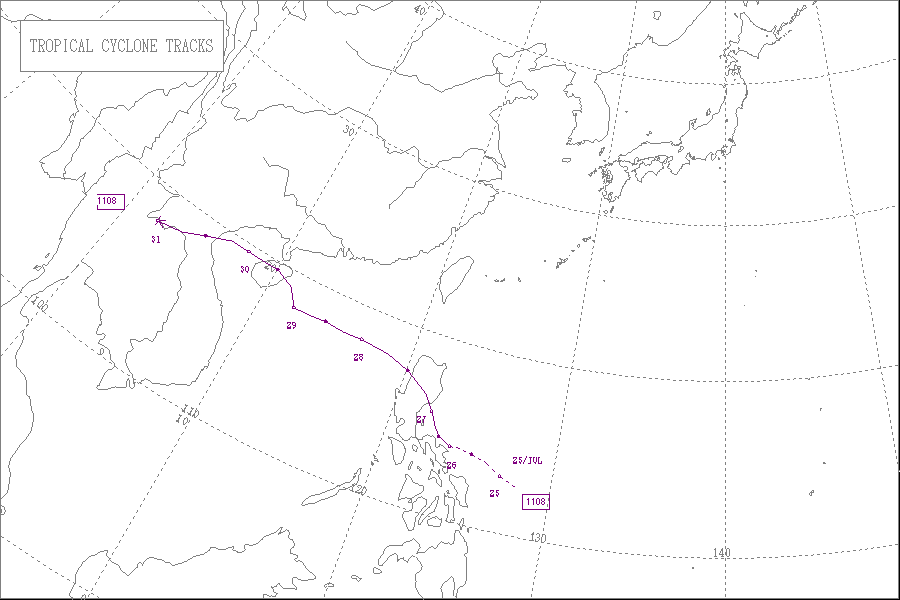
Meteorological history
Early on 22 July, an area of low pressure formed to the east of Philippines. The system gradually drifted west over the next few days and late on 24 July, the Joint Typhoon Warning CenterJoint Typhoon Warning Center
The Joint Typhoon Warning Center is a joint United States Navy – United States Air Force task force located at the Naval Maritime Forecast Center in Pearl Harbor, Hawaii...
Started Monitoring the system as a Tropical Depression. Early the next day, the Japan Meteorological Agency
Japan Meteorological Agency
The or JMA, is the Japanese government's weather service. Charged with gathering and reporting weather data and forecasts in Japan, it is a semi-autonomous part of the Ministry of Land, Infrastructure and Transport...
(JMA) upgraded the area of low pressure into a Tropical Depression. A few hours later, the Philippine Atmospheric, Geophysical and Astronomical Services Administration
Philippine Atmospheric, Geophysical and Astronomical Services Administration
The Philippine Atmospheric, Geophysical and Astronomical Services Administration is a Philippine national institution dedicated to provide flood and typhoon warnings, public weather forecasts and advisories, meteorological, astronomical, climatological, and other specialized information and...
(PAGASA) started monitoring the system as a Tropical Depression and named it 'Juaning'. The system continued to drift westwards and strengthened rapidly. On midnight that day, the JMA further upgraded the system into a Tropical Storm, naming it Nock-Ten, an anglicization of the Lao language
Lao language
Lao or Laotian is a tonal language of the Tai–Kadai language family. It is the official language of Laos, and also spoken in the northeast of Thailand, where it is usually referred to as the Isan language. Being the primary language of the Lao people, Lao is also an important second language for...
nok ten, ນົກເຕັນ,http://www.rfa.org/lao/news-about-laos/storm-nockten-will-reach-laos-07292011132553.html, meaning 'kingfisher',http://lad.nafri.org.la/agrovoc/wordblockf_de_la.php?mainword=%E0%BA%99%E0%BA%BB%E0%BA%81%E0%BB%80%E0%BA%95%E0%BA%B1%E0%BA%99&mainid=4104&lang=LA.
Early on 27 July, the JMA reported that Nock-ten continued to strengthen and upgraded it to a Severe Tropical Storm. A few hours later, the JTWC reported that Nock-ten rapidly intensified to a category 1 typhoon and made its landfall over northern Aurora (province) and started weakening. Later the same day, the JMA reported that Nock-ten has exited the Luzon
Luzon
Luzon is the largest island in the Philippines. It is located in the northernmost region of the archipelago, and is also the name for one of the three primary island groups in the country centered on the Island of Luzon...
island at Candon maintaining severe tropical storm strength. However, overnight, the storm rapidly weakened and the JMA downgraded it into a minor tropical storm the next day. On 29 July, the storm gradually regained strength and approached south China coast at Qionghai
Qionghai
-Other:Qionghai is historically associated with the Red Detachment of Women, an all-female company of the Chinese Red Army who survived Nationalist persecution...
, China. Later that day, the storm strengthened over land and headed north towards Hainan
Hainan
Hainan is the smallest province of the People's Republic of China . Although the province comprises some two hundred islands scattered among three archipelagos off the southern coast, of its land mass is Hainan Island , from which the province takes its name...
's provincial capital region Haikou
Haikou
Hǎikǒu , is the capital and most populous city of Hainan Province, in the People's Republic of China. It is situated on the northern coast of Hainan, by the mouth of the Nandu River...
. The storm weakened rapidly and at midnight that day, the JMA, issuing their final warning on the system, downgrading it into a tropical low.
Preparations and impact
| Region | Fatalities | Missing | Damage (US$) |
|---|---|---|---|
| Philippines | 75 | 9 | 65.73 million |
| China | 2 | 0 | 58 million |
| Vietnam and Laos |
20 | 0 | 199,563 |
| Thailand | 31 | 1 | 2.33 million |
| Total | 128 | 10 | 126.3 million+ |
Philippines
The provinces of AlbayAlbay
Albay is a province of the Philippines located in the Bicol Region in Luzon. Its capital is Legazpi City and the province borders Camarines Sur to the north and Sorsogon to the south. Also to the northeast is Lagonoy Gulf....
, Camarines Norte
Camarines Norte
Camarines Norte is a province of the Philippines located in the Bicol Region in Luzon. Its capital is Daet and the province borders Quezon to the west and Camarines Sur to the south.-Demographics:...
and Camarines Sur
Camarines Sur
Camarines Sur is a province of the Philippines located in the Bicol Region in Luzon. Its capital is Pili and the province borders Camarines Norte and Quezon to the north, and Albay to the south...
were reported to be completely flooded by rain. Minor damage to rice crops was reported. Heavier rains were expected throughout the day as the system exited land into the South China Sea and reintensified. The number of missing was raised to 31 after 25 crewmembers of a fishing boat were reported missing when their boat was caught in the storm off Masbate
Masbate
Masbate is an island province of the Philippines located in the Bicol Region. Its capital is Masbate City and consists of three major islands: Masbate, Ticao and Burias.-History:...
. All classes in Luzon
Luzon
Luzon is the largest island in the Philippines. It is located in the northernmost region of the archipelago, and is also the name for one of the three primary island groups in the country centered on the Island of Luzon...
from Pre-school to college levels on 26 and 27 July were suspended. In Northern Luzon, Nock-ten's heavy rainfall caused widespread flooding in the area. The national roads were impassable and landslides were reported. About 26 domestic flights were cancelled from 26 to 27 July due to heavy rains and strong winds. The death toll is now upgraded to 27 and more than 60 people are now listed as missing. The National Disaster Risk Reduction and Management Council began rescuing stranded people and searching for fishermen who were lost in the storm. On 28 July, the death toll was put at 35 as two government mines bureau staffers and the two police officers with them were recovered from flood waters and landslides in Luzon. By that time, the storm displaced a total of 728,554 people from several Philippine provinces in Luzon
Luzon
Luzon is the largest island in the Philippines. It is located in the northernmost region of the archipelago, and is also the name for one of the three primary island groups in the country centered on the Island of Luzon...
within the Ilocos Region
Ilocos Region
The Ilocos region or Region I is a Region of the Philippines and is located in the northwest of Luzon. It borders to the east the regions of the Cordillera Administrative Region and Cagayan Valley and to the south the region of Central Luzon...
, Central Luzon
Central Luzon
Central Luzon , also known as Region III , is an administrative division or region of the Republic of the Philippines, primarily serve to organize the 7 provinces of the vast central plain of the island of Luzon , for administrative convenience...
and Bicol Region
Bicol Region
The Bicol Region or Bicolandia is one of the 17 regions of the Philippines. Its regional center is Legazpi City...
. Later that day, the government accused the Philippine Atmospheric, Geophysical and Astronomical Services Administration
Philippine Atmospheric, Geophysical and Astronomical Services Administration
The Philippine Atmospheric, Geophysical and Astronomical Services Administration is a Philippine national institution dedicated to provide flood and typhoon warnings, public weather forecasts and advisories, meteorological, astronomical, climatological, and other specialized information and...
(PAGASA) for issuing inaccurate weather forecasts about the tropical storm.
On 29 July, the Philippine death toll was put up to 41 as more bodies were recovered from the flooded areas in Luzon
Luzon
Luzon is the largest island in the Philippines. It is located in the northernmost region of the archipelago, and is also the name for one of the three primary island groups in the country centered on the Island of Luzon...
. The National Disaster Risk Reduction and Management Council (NDRRMC) announced the total damage caused by the storm to Philippines was US$26,896,788.. Among the dead was the mother of Joey Salceda
Joey Salceda
Jose Clemente "Joey" Sarte Salceda is the governor of the province of Albay in the Philippines. Prior to that, he was a three-year term representative of the Third District of Albay and was appointed as Presidential Chief of Staff on February 10, 2007 after the resignation of Michael Defensor...
, the governor of Albay
Albay
Albay is a province of the Philippines located in the Bicol Region in Luzon. Its capital is Legazpi City and the province borders Camarines Sur to the north and Sorsogon to the south. Also to the northeast is Lagonoy Gulf....
province. She died on Wednesday of head trauma after slipping on the stairs during a power outage caused by the tropical storm. On 30 July, the death toll was again increased to 50. The NDRRMC also upgraded the total damage to infrastructure and agriculture to US$34,809,609.08. Most of the dead were drowned, hit by fallen tree or electric posts, or were buried in landslides. The majority of those affected are from the worst hit Bicol region. Many communities in the Bicol region were in need of potable water, electricity and work crews to clear all the debris and mangled up roads. on August 2, the NDRRMC, again increased the philippine death toll to 66 and the total damage to infrastructure and agriculture to US$41,811,413.49. Two days later, a survey by NDCC showed that school buildings were the worst hit in the entire nation. Damage to the school buildings alone was reported to be at a staggering US$13,794,381, and the total damage to Agriculture, Infrastructure and Schools was put at US$65,730,769.69. The number of dead was also upgraded to 69 and the number of missing was downgraded to 14. On August 5, the Philippine death toll was re-upgraded to 75, and the number of missing was downgraded to 9. According to the NDRRMC, the Philippine government has spent a total of US$ 650,653.10 in assisting the victims of the storm.
China
On 25 July, Hong Kong issued Signal No. 1 for Hong Kong. On 28 July, the residents of western GuangdongGuangdong
Guangdong is a province on the South China Sea coast of the People's Republic of China. The province was previously often written with the alternative English name Kwangtung Province...
started preparing for the storm when China's flood control authority launched an emergency response. The storm was originally expected to brush the South China coast by 29 July, However it gradually slowed down. As the system neared the Chinese coasts, China's meteorological authority issued a yellow alert and was predicting heavy to very heavy rainfall in parts of the Sichuan Basin
Sichuan basin
The Sichuan Basin is a lowland region in southwestern China. Despite its historical name, it is not only synonymous to Sichuan province, comprising its central and eastern portions as well as part of Chongqing Municipality...
. The provinces of Guangdong
Guangdong
Guangdong is a province on the South China Sea coast of the People's Republic of China. The province was previously often written with the alternative English name Kwangtung Province...
, Guangxi and Hainan
Hainan
Hainan is the smallest province of the People's Republic of China . Although the province comprises some two hundred islands scattered among three archipelagos off the southern coast, of its land mass is Hainan Island , from which the province takes its name...
were also strictly alerted about the storm. On 29 July, some 36,000 sea vessels carrying more than 120,000 labourers on board were warned about the severe storm over the south china sea. With that, some 26,000 fishing boats China's Hainan Province have returned to port.
As the storm approached coast, later that day, 14 flights from Hainan
Hainan
Hainan is the smallest province of the People's Republic of China . Although the province comprises some two hundred islands scattered among three archipelagos off the southern coast, of its land mass is Hainan Island , from which the province takes its name...
's provincial capital Haikou
Haikou
Hǎikǒu , is the capital and most populous city of Hainan Province, in the People's Republic of China. It is situated on the northern coast of Hainan, by the mouth of the Nandu River...
were cancelled. The rail ferry service to Mainland China
Mainland China
Mainland China, the Chinese mainland or simply the mainland, is a geopolitical term that refers to the area under the jurisdiction of the People's Republic of China . According to the Taipei-based Mainland Affairs Council, the term excludes the PRC Special Administrative Regions of Hong Kong and...
was also suspended because of the storm's fury. The storm was originally expected to turn west after landfall over Hainan. However, the storm headed north and hit Hainan's provincial capital Haikou
Haikou
Hǎikǒu , is the capital and most populous city of Hainan Province, in the People's Republic of China. It is situated on the northern coast of Hainan, by the mouth of the Nandu River...
. As a result, some 27,700 people were evacuated from Hainan's low lying area and some 2,602 fishing ships have returned to ports. Heavy rain and strong winds have halted all shipping services across the Qiongzhou Strait
Qiongzhou Strait
The Qiongzhou Strait , also called the Hainan Strait, is a body of water that separates the Leizhou Peninsula in Guangdong, southern China, to the north from Hainan Island to its south...
. Later the next day, China's flood control authorities have reported to have evacuated a total of 189,033 to safe areas in the southern island province of Hainan. On 31 July, the China's provincial flood control office reported that, in total, Nock-ten claimed 2 lives and caused widespread damage worth US$58 million in Hainan
Hainan
Hainan is the smallest province of the People's Republic of China . Although the province comprises some two hundred islands scattered among three archipelagos off the southern coast, of its land mass is Hainan Island , from which the province takes its name...
province.
Vietnam, Laos and Thailand
As the storm neared land, a Vietnamese boat carrying 12 fishermen was capsized and drifted towards PalawanPalawan
Palawan is an island province of the Philippines located in the MIMAROPA region or Region 4. Its capital is Puerto Princesa City, and it is the largest province in the country in terms of total area of jurisdiction. The islands of Palawan stretch from Mindoro in the northeast to Borneo in the...
, near the Philippines. A few hours later, all the 12 fishermen were rescued and safeguarded. The Thai Meteorological Department issued warnings for Phuket
Phuket Province
Phuket , formerly known as Thalang and, in Western sources, Junk Ceylon , is one of the southern provinces of Thailand...
and much of Thailand as the storm neared land. Strong winds and heavy rain were predicted to affect the Andaman Sea
Andaman Sea
The Andaman Sea or Burma Sea is a body of water to the southeast of the Bay of Bengal, south of Burma, west of Thailand and east of the Andaman Islands, India; it is part of the Indian Ocean....
. As a result, the people of Thailand’s northern provinces started preparing for possible floods and strong wind. The Yom River
Yom River
The Yom River is the dime main tributary of the Nan River . The Yom originates in Pong district, Phayao Province, Thailand...
and the Nan River
Nan River
The Nan River is a river in Thailand. It is one of the most important tributaries of the Chao Phraya River.-Geography:The Nan River originates in Nan Province. The provinces along the river after Nan Province are Uttaradit, Phitsanulok and Phichit. The Yom River joins the Nan River at Chum Saeng...
were reported to be almost overflowing damaging some rice paddy fields and farmland. About 650,000 people were evacuated from low-lying areas in the Tonkin Gulf region in preparation for the storm. On 30 July, just before the storms's final landfall, the storm already started claiming lives in Vietnam, with one man killed by the oceanic waves. As a result, Meteorological officials repeated their warning that small boats should not put to sea. Later that day, some 6 flights of Vietnam Airlines
Vietnam Airlines
Vietnam Airlines Company Limited, trading as Vietnam Airlines , is the national flag carrier of Vietnam. Founded in 1956 under the name Vietnam Civil Aviation, the airline was established as a state enterprise in April 1989. Vietnam Airlines is headquartered in Long Bien, Hanoi, with hubs at Noi...
were cancelled and many more were delayed because of the storm. Over the next day, after the storms final landfall, some 6,200 acres of rice and other crop fields were reported to be completely submerged by the rain waters. The storm's consequences were described as "not considerable" as the storm was weaker than expected and did not cause much damage.
On 31 July, the Vietnamese death toll was upgraded to three, as another man was killed by electric shock when lightning stroke the electric pole and a 13 year old child died drowning. The storm damaged at least four fishing vessels, sinking one from Quang Ngai Province
Quang Ngai Province
Quảng Ngãi is a province in the South Central Coast region of Vietnam, on the coast of South China Sea. It is located 883 km south of Hanoi and 838 km north of Ho Chi Minh City.-History:...
near Spratly Islands
Spratly Islands
The Spratly Islands are a group of more than 750 reefs, islets, atolls, cays and islands in the South China Sea. The archipelago lies off the coasts of the Philippines and Malaysia , about one third of the way from there to southern Vietnam. They comprise less than four square kilometers of land...
. The north and northeastern provinces of Thailand were reported to be completely flooded and some townships were said to be under a staggering 80 centimetres of water. As a result, two people were reported to have gone missing in the flood waters. Flooding occurred in many northern and central provinces. Heavy rainfall inundated low lying areas of the Khammuan and Borikhamxay. 25 villages and 15 schools remained underwater, even two days after the storm. Thailand tourism was luckily not very much affected by the system though most of the places in the North were completely flooded, leaving several hotels filled with water. On August 5, the Thai death toll was put at 7 sending the total death toll of Nock-ten to 81. At least 4 people are reported to have gone missing in the storm. Soon afterwards, the death toll was re-upgraded to 13 while the number of missing was downgraded to 1 as more bodies were found in the flood waters associated with Nock-ten. damage figures were expected to be at US$ $2.33 million. On the next day, the thai death toll was further upgraded to 20 by the Department of Disaster Mitigation and Protection. It was reported that some 20 provinces were submerged by the system, out of which 16 provinces including northern Chiangmai, Phare
Phare
The Phare programme is one of the three pre-accession instruments financed by the European Union to assist the applicant countries of Central and Eastern Europe in their preparations for joining the European Union....
, Lumpoon, Lumpang, Mae Hongsorn and Uttaradit
Uttaradit
Uttaradit is a town in Thailand, capital of the Uttaradit province. The town covers the whole tambon Tha It of Mueang Uttaradit district...
provinces and northeastern Udon Thani
Udon Thani
Udon Thani is a city in Isan, north-east Thailand, and the capital of Udon Thani Province.-Location:The province of Udon Thani has a population of 1,467.200, the city alone 500.000. Geographical location and is approximately 560 km from Bangkok...
, Bungkarn, and Sakon Nakorn provinces and central Petchaboon, Nakorn Sawan, Sukhothai
Sukhothai
Sukhothai may refer to:* Sukhothai , the historic city* Sukhothai Historical Park* Sukhothai Kingdom, the historic Thai kingdom* Sukhothai Province, one of the northern provinces of ThailandSukhothai may also refer to:...
, Pijit, Pitchsanulok and Nakorn Phanom were still in water.
Aftermath
On August 11, 10 days after the storm dissipated, several regions in ThailandThailand
Thailand , officially the Kingdom of Thailand , formerly known as Siam , is a country located at the centre of the Indochina peninsula and Southeast Asia. It is bordered to the north by Burma and Laos, to the east by Laos and Cambodia, to the south by the Gulf of Thailand and Malaysia, and to the...
were still underwater after flooding associated with the storm. The storm was reported to have affected a total of at least 1,371,137 people and killed 22 throughout the country. The floodwaters were still affecting 411,585 people in the provinces of Phrae
Phrae
Phrae is a town in northern Thailand, capital of the Phrae Province.The town covers the whole tambon Nai Wiang of the Mueang Phrae district. It covers an area of 9 km² and as of 2005 it has a population of 17,971....
, Sukhothai
Sukhothai
Sukhothai may refer to:* Sukhothai , the historic city* Sukhothai Historical Park* Sukhothai Kingdom, the historic Thai kingdom* Sukhothai Province, one of the northern provinces of ThailandSukhothai may also refer to:...
, Uttaradit
Uttaradit
Uttaradit is a town in Thailand, capital of the Uttaradit province. The town covers the whole tambon Tha It of Mueang Uttaradit district...
, Phichit
Phichit
Phichit is a town in northern Thailand, capital of the Phichit Province. It covers the whole tambon Nai Mueang of Mueang Phichit district, an area of 12.017 km²...
, Phitsanulok
Phitsanulok
Phitsanulok is an important and historic city in lower northern Thailand and is the capital of Phitsanulok Province, which stretches all the way to the Laotian border. Phitsanulok is one of the oldest cities in Thailand, founded over 600 years ago...
, Tak
Tak Province
Tak is one of the northern provinces of Thailand. Neighboring provinces are Mae Hong Son, Chiang Mai, Lamphun, Lampang, Sukhothai, Kamphaeng Phet, Nakhon Sawan, Uthai Thani and Kanchanaburi...
, Nakhon Sawan
Nakhon Sawan Province
Nakhon Sawan is one of the provinces of Thailand. Neighboring provinces are Kamphaeng Phet, Phichit, Phetchabun, Lop Buri, Sing Buri, Chai Nat, Uthai Thani and Tak.- Etymology :...
, Ayutthaya and Mukdahan
Mukdahan
Mukdahan capital of Mukdahan province, became Thailand's 73d province in 1982. Located in the northeastern region of the country, on the banks of the river Mekong, it was formerly as district of Nakhon Phanom Province...
. Several days later, the death toll still continued to rise as the floods continued to affect several provinces of the Nation.
In Vietnam
Vietnam
Vietnam – sometimes spelled Viet Nam , officially the Socialist Republic of Vietnam – is the easternmost country on the Indochina Peninsula in Southeast Asia. It is bordered by China to the north, Laos to the northwest, Cambodia to the southwest, and the South China Sea –...
, the storm damaged nearly 2,450,385 acres of farmland
Farmland
Farmland generally refers to agricultural land, or land currently used for the purposes of farming. It may also refer to:*Arable land, land capable of cultivating crops*Farmland, Indiana, a town in the United States...
and affected some 1.1 million people, killing 20 in flooding associated with the storm. A 1111 hotline
Hotline
In telecommunication, a hotline is a point-to-point communications link in which a call is automatically directed to the preselected destination without any additional action by the user when the end instrument goes off-hook...
was opened to receive complaints about floods and collect food donations. The total damage to the Laos
Laos
Laos Lao: ສາທາລະນະລັດ ປະຊາທິປະໄຕ ປະຊາຊົນລາວ Sathalanalat Paxathipatai Paxaxon Lao, officially the Lao People's Democratic Republic, is a landlocked country in Southeast Asia, bordered by Burma and China to the northwest, Vietnam to the east, Cambodia to the south and Thailand to the west...
was estimated to be at 16 billion Kip
Lao kip
The kip "Currency Lao Kip") is the currency of Laos since 1952. One kip is divided into 100 att . The official name is: ເງີນກີບລາວ, lit. Other languages say: ; code: LAK; sign: ' or ', encoded .-Free Lao Kip:...
or US$ 199,563.
Retirement
The name that PAGASA gave to Nock-ten, Juaning, was retired following this storm because of the damage. The replacement name has yet to be chosen.External links
- The JMA's Best Track Data on Severe Tropical Storm Nock-ten (1108)
- The JMA's RSMC Best Track Data (Graphics) on Severe Tropical Storm Nock-ten (1108)
- The JMA's RSMC Best Track Data (Text)