
Tuya Range
Encyclopedia
The Tuya Range is a range of tuya
s, located in the Stikine Ranges
of the Cassiar Mountains
in the far northr of the Canadian province of British Columbia
, near its border with the Yukon Territory
and to the southwest of Watson Lake, Yukon
, which is the nearest major settlement.
and its tributary, Butte Creek
, while the southeast flank is formed by the Cottonwood River and its tributaries (the Cottonwood is a tributary of the Dease River
, the Tuya of the Stikine
). The range's northern boundary is formed by the upper Jennings River
, a tributary of the Teslin system which is part of the Yukon River
drainage. The Continental Divide transits the eastern side of the range, though does not touch on its highest summit, Ash Mountain
, which is at the north end of the range and is within the basin of the Jennings. The range has an area of 777 km² (300 sq mi) and, other than Ash Mountain, includes Tuya Butte
, Mathews Tuya
, Caribou Tuya
, and South Tuya
. All of these are part of the Tuya Volcanic Field
, which includes other volcanic features north and west of the range
Ash Mountain 2115 m (6,939 ft) is the highest tuya in the range. The nearby Kawdy Plateau
to the west, to the southwest of Kawdy Mountain, is near-entirely formed by the spectacular shield volcano
of the Level Mountain Range
.
Tuya Butte
1685 m (5,528 ft) was the first tuya analyzed in the geological literature, and its name has since become standard worldwide among volcanologist
s in referring to and writing about tuyas. The Tuya Mountains Provincial Park
was recently established to protect this unusual landscape, which lies north of Tuya Lake
and south of the Jennings River
near the boundary with the Yukon Territory.
Black Spruce
is a dominant tree in this area; this species is near the western limit of its range.
Tuya
A tuya is a type of distinctive, flat-topped, steep-sided volcano formed when lava erupts through a thick glacier or ice sheet. They are somewhat rare worldwide, being confined to regions which were covered by glaciers and also had active volcanism during the same time period.-Formation:Tuyas are...
s, located in the Stikine Ranges
Stikine Ranges
The Stikine Ranges are a mountain range in northwestern British Columbia, Canada. They are the northernmost subdivision of the Cassiar Mountains and among the least explored and most undeveloped parts of the province.-Sub-ranges:*Beady Range...
of the Cassiar Mountains
Cassiar Mountains
The Cassiar Mountains are the most northerly group of the Northern Interior Mountains in the Canadian province of British Columbia and the Yukon Territory. They lie north and west of the Omineca Mountains, west of the northernmost Rockies and the Rocky Mountain Trench, north of the Hazelton...
in the far northr of the Canadian province of British Columbia
British Columbia
British Columbia is the westernmost of Canada's provinces and is known for its natural beauty, as reflected in its Latin motto, Splendor sine occasu . Its name was chosen by Queen Victoria in 1858...
, near its border with the Yukon Territory
Yukon
Yukon is the westernmost and smallest of Canada's three federal territories. It was named after the Yukon River. The word Yukon means "Great River" in Gwich’in....
and to the southwest of Watson Lake, Yukon
Watson Lake, Yukon
Watson Lake is a town at historical mile 635 on the Alaska Highway in the southeastern Yukon close to the British Columbia border. Population in December 2004 was 1,547 ....
, which is the nearest major settlement.
Boundaries and landforms
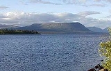
The northern and northwest side of the range is drained by tributaries of the Cottonwood River; the southern and southwestern flank is formed by Tuya LakeTuya Lake
Tuya Lake, located in northwestern British Columbia, Canada, presumably derives its name from the presence of nearby steep-sided, flat-topped volcanoes, known as tuyas...
and its tributary, Butte Creek
Butte Creek
Butte Creek may refer to:*Butte Creek, California, former town in Butte County*Butte Creek , a Sacramento River tributary at **Little Butte Creek , a tributary of Butte Creek at...
, while the southeast flank is formed by the Cottonwood River and its tributaries (the Cottonwood is a tributary of the Dease River
Dease River
The Dease River flows through northwestern British Columbia, Canada and is a tributary of the Liard River. The river descends from Dease Lake, though its ultimate origin is in the headwater of Little Dease Creek at Snow Peak, approximately 50 km to the west of the lake...
, the Tuya of the Stikine
Stikine River
The Stikine River is a river, historically also the Stickeen River, approximately 610 km long, in northwestern British Columbia in Canada and southeastern Alaska in the United States...
). The range's northern boundary is formed by the upper Jennings River
Jennings River
The Jennings River is a river in far northern British Columbia, Canada, rising in the northern reaches of the Stikine Ranges of the Cassiar Mountains, at first running southwest, then turning northeast near the Tuya Range to enter Teslin Lake at its southern end, just to the east of the estuary of...
, a tributary of the Teslin system which is part of the Yukon River
Yukon River
The Yukon River is a major watercourse of northwestern North America. The source of the river is located in British Columbia, Canada. The next portion lies in, and gives its name to Yukon Territory. The lower half of the river lies in the U.S. state of Alaska. The river is long and empties into...
drainage. The Continental Divide transits the eastern side of the range, though does not touch on its highest summit, Ash Mountain
Ash Mountain (British Columbia)
Ash Mountain is the highest summit in the Tuya Range of the Stikine Ranges in northcentral British Columbia, Canada, located immediately north of High Tuya Lake at the north end of Tuya Mountains Provincial Park. It is one of the six tuyas clustered close to Tuya Lake...
, which is at the north end of the range and is within the basin of the Jennings. The range has an area of 777 km² (300 sq mi) and, other than Ash Mountain, includes Tuya Butte
Tuya Butte
Tuya Butte is a tuya in the Tuya Range of north-central British Columbia, Canada. It is a bit less isolated from other ranges than neighbouring Mount Josephine...
, Mathews Tuya
Mathews Tuya
Mathews Tuya is a subglacial mound in northcentral British Columbia. It is one of the six tuyas close to Tuya Lake. It has been partly glaciated so it is probably older than 10,000 years. The other volcanoes in the area include Tuya Butte, South Tuya and Ash Mountain...
, Caribou Tuya
Caribou Tuya
Caribou Tuya is a basaltic subglacial mound in far northwestern British Columbia that began eruptive activity under glacial ice during the Fraser glaciation . Like Ash Mountain and South Tuya, sections of the subglacial mound reveal a consistent stratigraphic progression from pillow lavas to...
, and South Tuya
South Tuya
South Tuya, also called Southern Tuya, is a tuya clustered around Tuya Lake in the Northern Cordilleran Volcanic Province in British Columbia, Canada...
. All of these are part of the Tuya Volcanic Field
Tuya Volcanic Field
The Tuya volcanic field is a volcanic field of tuyas located in far northern British Columbia, Canada, near the border with the Yukon Territory and focussed on the area of the Tuya Range, a subrange of the Stikine Ranges of the Cassiar Mountains, though some vents are in the Kawdy Plateau, the...
, which includes other volcanic features north and west of the range
Ash Mountain 2115 m (6,939 ft) is the highest tuya in the range. The nearby Kawdy Plateau
Kawdy Plateau
The Kawdy Plateau is a plateau in northern British Columbia, Canada, located between the Nahlin and Tuya Rivers. It includes the granitic Atsutla Range and Nazcha Hills and the volcanic Kawdy Mountain.-References:* in the Canadian Mountain Encyclopedia....
to the west, to the southwest of Kawdy Mountain, is near-entirely formed by the spectacular shield volcano
Shield volcano
A shield volcano is a type of volcano usually built almost entirely of fluid lava flows. They are named for their large size and low profile, resembling a warrior's shield. This is caused by the highly fluid lava they erupt, which travels farther than lava erupted from more explosive volcanoes...
of the Level Mountain Range
Level Mountain Range
The Level Mountain Range, also known as Level Mountain, is a mountain range in Cassiar Country, northwestern British Columbia, Canada, located just northeast of Callison Ranch, southwest of Dease Lake and about north of Mount Edziza. It consists of a massive shield volcano and lies on the Nahlin...
.
Tuya Butte
Tuya Butte
Tuya Butte is a tuya in the Tuya Range of north-central British Columbia, Canada. It is a bit less isolated from other ranges than neighbouring Mount Josephine...
1685 m (5,528 ft) was the first tuya analyzed in the geological literature, and its name has since become standard worldwide among volcanologist
Volcanologist
A volcanologist is a person who studies the formation of volcanoes, and their current and historic eruptions. Volcanologists frequently visit volcanoes, especially active ones, to observe volcanic eruptions, collect eruptive products including tephra , rock and lava samples...
s in referring to and writing about tuyas. The Tuya Mountains Provincial Park
Tuya Mountains Provincial Park
Tuya Mountains Provincial Park is a provincial park in British Columbia, Canada, protecting the Tuya Range, a volcanic region at the head of the Tuya River. The park is located on the north side of Tuya Lake. The park is named for nearby Tuyas, steep-sided, flat-topped types of volcano....
was recently established to protect this unusual landscape, which lies north of Tuya Lake
Tuya Lake
Tuya Lake, located in northwestern British Columbia, Canada, presumably derives its name from the presence of nearby steep-sided, flat-topped volcanoes, known as tuyas...
and south of the Jennings River
Jennings River
The Jennings River is a river in far northern British Columbia, Canada, rising in the northern reaches of the Stikine Ranges of the Cassiar Mountains, at first running southwest, then turning northeast near the Tuya Range to enter Teslin Lake at its southern end, just to the east of the estuary of...
near the boundary with the Yukon Territory.
Black Spruce
Black Spruce
Picea mariana is a species of spruce native to northern North America, from Newfoundland west to Alaska, and south to northern New York, Minnesota and central British Columbia...
is a dominant tree in this area; this species is near the western limit of its range.
See also
- Volcanism of Canada
- Volcanism of Western CanadaVolcanism of Western CanadaVolcanism of Western Canada produces lava flows, lava plateaus, lava domes, cinder cones, stratovolcanoes, shield volcanoes, submarine volcanoes, calderas, diatremes and maars, along with examples of more less common volcanic forms such as tuyas and subglacial mounds.-Volcanic belts:*Anahim...
- List of volcanoes in Canada