

Cumberland Island
Encyclopedia
Cumberland Island is one of the Sea Islands
. Cumberland is the largest in terms of continuously exposed land area of Georgia's
barrier island
s. It is located on the Atlantic Ocean
off the coast of the U.S. state of Georgia and is part of Camden County
(30°51′N, 81°27′W). The island is 17.5 miles (28.2 km) long, with an area of 36,415 acres (147.37 km² or 56.25 square miles), including 16850 acres (68.2 km²) of marsh
, mudflat
s, and tidal creeks
. There is no bridge to the island. Many visitors reach the island by the Cumberland Ferry; a convenient access is located in downtown St. Marys, Georgia
.
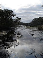 The island has three major ecosystem regions. Along the western edge of the island there are large areas of salt marsh
es. One will also see gnarled live oak trees covered with Spanish moss
and the palmetto
plants at the edge of Cumberland's dense maritime forest. Cumberland Island's most famous ecosystem is its beach, which stretches over 17 miles (27.4 km). The island is home to many native interesting animals, as well as non-native species. There are White-tailed deer
, squirrel
s, Raccoon
s, Nine-banded Armadillo
s, Wild Boars
, American Alligator
s, as well as many marshland inhabitants. It is also famous for its wild horses roaming free on the island.
. Its inhabitants were part of the Mocama
, a Timucua
group who spoke the Mocama dialect. In the 17th century the island and the adjacent coast were controlled by the Tacatacuru
chiefdom. The main village, known as Tacatacuru, was located towards the southern end of the island; during the time of European colonization, the Spanish recorded the names of at least six more villages on the island, and eleven more were located on the mainland.
missionary province of Spanish Florida
. When the Spanish arrived in 1566, they named the island San Pedro. They built a garrison and mission, San Pedro de Mocama
, near the village of Tacatacuru. The mission operated from 1587 to 1660. It was one of the main mission centers, situated at a major Mocama site. Another Spanish mission on Cumberland was Puturiba, which operated from 1595–1597. An additional mission, San Phelipe, was relocated from the North Newport River to the northern end of Cumberland from 1670–1684.
Historical records indicate that until 1681, there were approximately 300 natives and several Spanish missionaries living on Cumberland Island. In 1683, French
pirates attacked Cumberland Island, looting and burning many of the buildings. Many of the natives and the Spanish missionaries fled the island. An attack in 1684 by the Spanish pirate Thomas Jingle led to the final abandonment of the island. The Tacatacuru relocated closer to St. Augustine, and Cumberland Island was thereafter occupied by the Yemassi. Most of the Mocama had converted to Christianity
before the island was abandoned. During the colonial years, many died of newly introduced infectious diseases, to which they had no natural immunity. Survivors retreated to St. Augustine to the south.
arrived at the Georgia coast in 1733. The name of Cumberland Island was given by a young Yamacraw named Toonahowi (the nephew of Chief Tomochichi who visited England with Oglethorpe.) He suggested the island be named for William Augustus, the 13-year old Duke of Cumberland
.
Oglethorpe established a hunting lodge called Dungeness, named after a headland in Kent, England. A fort was erected at the southern point of the island called Fort William
. At the northern end of the island, Oglethorpe built Fort St. Andrews. For a decade the small village of Berrimacke existed near the fort. The forts were built to defend English settlements to the north from the Spanish in Florida
.
After the English defeated the Spanish in Battle of Bloody Marsh
in 1742, the need for the forts ended. They abandoned the forts and eventually the village disappeared. No trace remains today of Fort William, and most signs of Fort St. Andrews have been washed away.
In the 1760s, the island was divided into royal grants but saw little activity. When naturalist William Bartram
visited the island in 1774, the island was mostly uninhabited.
purchased land on the island in 1783 to harvest live oaks for ship building. Wood from the island was used to build the USS Constitution
, "Old Ironsides." Greene died in 1786. His wife, Catherine, remarried Phineas Miller ten years later, and they built a huge, four-story tabby
mansion on top of an Indian shell mound. She named it Dungeness
after Oglethorpe's hunting lodge. The mansion, with 6 feet (1.8 m) thick walls at the base, featured four chimneys and 16 fireplaces, and was surrounded by 12 acres (48,562.3 m²) of gardens. Dungeness was the site of many special social galas, where statesmen and military leaders enjoyed the Millers' hospitality. When the island was briefly occupied during the War of 1812
, the British used Dungeness as their headquarters. They also freed the American slaves on the island.
The Millers became the first major planters on the Island. They, like many others, cultivated the valuable and labor-intensive crop of Sea Island cotton. They held a total of 210 slaves to work the plantation.
In 1818, Gen. "Lighthorse" Harry Lee, a Revolutionary War hero and old friend of Nathaniel and Catherine Greene, (and the father of Confederate general Robert E. Lee.), came to Cumberland Island. He was in failing health and was returning from the West Indies when he asked to be taken to his old friend's estate of Dungeness. After a month of illness, he died on March 25 and was buried on the island. His son, Confederate General Robert E. Lee
, had a tombstone placed over the grave and visited his father's final resting place several times. In 1913, the body of Harry Lee was reinterred at Lexington, Virginia
, to lie beside his famous son, but his gravestone was left on Cumberland Island.
Records show that in 1846, there were 36 white people and 400 enslaved people. With the end of slavery after the Civil War and a changing economy, the plantation was not profitable. Dungeness deteriorated and the family moved away. Dungeness burned down in 1866.
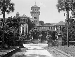 In the 1880s Thomas M. Carnegie
, brother of steel magnate Andrew Carnegie
, and his wife Lucy bought land on Cumberland for a winter retreat. In 1884, they began building a mansion on the site of Dungeness, though Carnegie never lived to see its completion. Lucy and their nine children continued to live on the island, naming their mansion Dungeness after that of Greene. Dungeness was designed as a 59-room Scottish castle. They also built pools, a golf course, and 40 smaller buildings to house the 200 servants who worked at the mansion. The last time Dungeness was used was for the 1929 wedding of a Carnegie daughter. After the Crash
and the Great Depression
, the family left the island and kept the mansion vacant. It burned in a 1959 fire, believed to have been started by a poacher
who had been shot in the leg by a caretaker weeks before. Today, the ruins of the mansion remain on the southern end of the island. The Carnegie family owned 90% of the island.
Lucy Carnegie had additional estates built on the island for her children. These include:
In the 1890s, "The Settlement" was established at the north end of the island as a residential area for black workers, as Georgia had passed laws requiring racial segregation of housing and public facilities. Discrimination may have been the basis of white workers on the plantation being paid $1 a day, while black workers received $0.50 per day; however, another reason for the discrepancy may have been that white workers were typically management or skilled labor while many of the black workers were not. The First African Baptist Church, established in The Settlement in 1893, was rebuilt in the 1930s. It is one of the few remaining structures of this community.
http://www.yosurfer.com/content/oceans_and_environment/shark_attack_file/all/usa/n/579
. NPS restricts access to 300 people on the island at a time, and campers are allowed to stay no more than 7 nights. A ferry runs twice a day to Cumberland Island from the mainland (St. Marys, Georgia
). The only other way to reach the island is by private boat. Visitors cannot bring vehicles or bikes on the ferry, and there are no paved roads or trails. Bikes are available for rent at the Sea Camp Dock, on a first-come, first-served basis. Visitors may bring their own bikes to the island via private or charter boat. Visitors walk everywhere they go, but Cumberland Island is less than six miles (10 km) wide at the widest point. The eastern seashore is 17.5 miles (28.2 km) of continuous beach. There is one camping area with running water and bathrooms with cold showers; the other camping sites do not have facilities. All food, ice and supplies must be shipped from the mainland, as there are no stores on the island.
Things to see include:
Sea Islands
The Sea Islands are a chain of tidal and barrier islands on the Atlantic Ocean coast of the United States. They number over 100, and are located between the mouths of the Santee and St. Johns Rivers along the coast of the U.S...
. Cumberland is the largest in terms of continuously exposed land area of Georgia's
Georgia (U.S. state)
Georgia is a state located in the southeastern United States. It was established in 1732, the last of the original Thirteen Colonies. The state is named after King George II of Great Britain. Georgia was the fourth state to ratify the United States Constitution, on January 2, 1788...
barrier island
Barrier island
Barrier islands, a coastal landform and a type of barrier system, are relatively narrow strips of sand that parallel the mainland coast. They usually occur in chains, consisting of anything from a few islands to more than a dozen...
s. It is located on the Atlantic Ocean
Atlantic Ocean
The Atlantic Ocean is the second-largest of the world's oceanic divisions. With a total area of about , it covers approximately 20% of the Earth's surface and about 26% of its water surface area...
off the coast of the U.S. state of Georgia and is part of Camden County
Camden County, Georgia
Camden County is a county located in the U.S. state of Georgia. It is one of the original counties of Georgia, created February 5, 1777. As of 2000, the population was 43,664. The 2007 Census Estimate shows a population of 48,689. The county seat is Woodbine.-History:The first European to land...
(30°51′N, 81°27′W). The island is 17.5 miles (28.2 km) long, with an area of 36,415 acres (147.37 km² or 56.25 square miles), including 16850 acres (68.2 km²) of marsh
Marsh
In geography, a marsh, or morass, is a type of wetland that is subject to frequent or continuous flood. Typically the water is shallow and features grasses, rushes, reeds, typhas, sedges, other herbaceous plants, and moss....
, mudflat
Mudflat
Mudflats or mud flats, also known as tidal flats, are coastal wetlands that form when mud is deposited by tides or rivers. They are found in sheltered areas such as bays, bayous, lagoons, and estuaries. Mudflats may be viewed geologically as exposed layers of bay mud, resulting from deposition of...
s, and tidal creeks
Creek (tidal)
A tidal creek, tidal channel, or estuary is the portion of a stream that is affected by ebb and flow of ocean tides, in the case that the subject stream discharges to an ocean, sea or strait. Thus this portion of the stream has variable salinity and electrical conductivity over the tidal cycle...
. There is no bridge to the island. Many visitors reach the island by the Cumberland Ferry; a convenient access is located in downtown St. Marys, Georgia
St. Marys, Georgia
-See also:*Cumberland Island*St. Marys Historic District*St. Marys Railroad-External links:***...
.
Ecology
Salt marsh
A salt marsh is an environment in the upper coastal intertidal zone between land and salt water or brackish water, it is dominated by dense stands of halophytic plants such as herbs, grasses, or low shrubs. These plants are terrestrial in origin and are essential to the stability of the salt marsh...
es. One will also see gnarled live oak trees covered with Spanish moss
Spanish Moss
Spanish moss is a flowering plant that grows upon larger trees, commonly the Southern Live Oak or Bald Cypress in the southeastern United States....
and the palmetto
Palmetto
-Botany:Members of several genera of small palms:*the genus Sabal of the Arecaceae family**Dwarf Palmetto**Sabal palmetto*Saw Palmetto, Serenoa repens*Silver saw palmetto, Acoelorraphe wrightii-Place names:United States...
plants at the edge of Cumberland's dense maritime forest. Cumberland Island's most famous ecosystem is its beach, which stretches over 17 miles (27.4 km). The island is home to many native interesting animals, as well as non-native species. There are White-tailed deer
White-tailed Deer
The white-tailed deer , also known as the Virginia deer or simply as the whitetail, is a medium-sized deer native to the United States , Canada, Mexico, Central America, and South America as far south as Peru...
, squirrel
Squirrel
Squirrels belong to a large family of small or medium-sized rodents called the Sciuridae. The family includes tree squirrels, ground squirrels, chipmunks, marmots , flying squirrels, and prairie dogs. Squirrels are indigenous to the Americas, Eurasia, and Africa and have been introduced to Australia...
s, Raccoon
Raccoon
Procyon is a genus of nocturnal mammals, comprising three species commonly known as raccoons, in the family Procyonidae. The most familiar species, the common raccoon , is often known simply as "the" raccoon, as the two other raccoon species in the genus are native only to the tropics and are...
s, Nine-banded Armadillo
Nine-banded Armadillo
The nine-banded armadillo , or the nine-banded, long-nosed armadillo, is a species of armadillo found in North, Central, and South America, making it the most widespread of the armadillos...
s, Wild Boars
Razorback
Razorback is an Americanism, loosely applied to any type of feral pig or wild boar in North America. The term has also appeared in Australia, to describe said animals in that country.-Introduction to the Americas:...
, American Alligator
American Alligator
The American alligator , sometimes referred to colloquially as a gator, is a reptile endemic only to the Southeastern United States. It is one of the two living species of alligator, in the genus Alligator, within the family Alligatoridae...
s, as well as many marshland inhabitants. It is also famous for its wild horses roaming free on the island.
Early settlement
First inhabitants were indigenous peoples who settled there as early as 4,000 years ago. Later inhabitants participated in the Savannah archaeological culture and spoke the Timucua languageTimucua language
Timucua is a language isolate formerly spoken in northern and central Florida and southern Georgia by the Timucua people. Timucua was the primary language used in the area at the time of Spanish arrival in Florida. Linguistic and archaeological studies suggest that it may have been spoken from...
. Its inhabitants were part of the Mocama
Mocama
The Mocama were a Native American people who lived in the coastal areas of what are now northern Florida and southeastern Georgia. A Timucua group, they spoke the dialect known as Mocama, the best-attested dialect of the Timucua language. Their territory extended from about the Altamaha River in...
, a Timucua
Timucua
The Timucua were a Native American people who lived in Northeast and North Central Florida and southeast Georgia. They were the largest indigenous group in that area and consisted of about 35 chiefdoms, many leading thousands of people. The various groups of Timucua spoke several dialects of the...
group who spoke the Mocama dialect. In the 17th century the island and the adjacent coast were controlled by the Tacatacuru
Tacatacuru
The Tacatacuru were a Timucua chiefdom located on Cumberland Island in what is now the U.S. state of Georgia in the 16th and 17th centuries. They were one of two chiefdoms of the Timucua subgroup known as the Mocama, who spoke the Mocama dialect of Timucuan and lived in the coastal areas of...
chiefdom. The main village, known as Tacatacuru, was located towards the southern end of the island; during the time of European colonization, the Spanish recorded the names of at least six more villages on the island, and eleven more were located on the mainland.
Spanish settlement
During the 16th and 17th centuries, Cumberland Island was part of the MocamaMocama
The Mocama were a Native American people who lived in the coastal areas of what are now northern Florida and southeastern Georgia. A Timucua group, they spoke the dialect known as Mocama, the best-attested dialect of the Timucua language. Their territory extended from about the Altamaha River in...
missionary province of Spanish Florida
Spanish Florida
Spanish Florida refers to the Spanish territory of Florida, which formed part of the Captaincy General of Cuba, the Viceroyalty of New Spain, and the Spanish Empire. Originally extending over what is now the southeastern United States, but with no defined boundaries, la Florida was a component of...
. When the Spanish arrived in 1566, they named the island San Pedro. They built a garrison and mission, San Pedro de Mocama
San Pedro de Mocama
San Pedro de Mocama was a Spanish Franciscan mission built in the mid-16th century on Cumberland Island in what is now the U.S. state of Georgia. It was part of the missions system of Spanish Florida, and was founded to serve the Tacatacuru, a chiefdom of the Timucua...
, near the village of Tacatacuru. The mission operated from 1587 to 1660. It was one of the main mission centers, situated at a major Mocama site. Another Spanish mission on Cumberland was Puturiba, which operated from 1595–1597. An additional mission, San Phelipe, was relocated from the North Newport River to the northern end of Cumberland from 1670–1684.
Historical records indicate that until 1681, there were approximately 300 natives and several Spanish missionaries living on Cumberland Island. In 1683, French
French people
The French are a nation that share a common French culture and speak the French language as a mother tongue. Historically, the French population are descended from peoples of Celtic, Latin and Germanic origin, and are today a mixture of several ethnic groups...
pirates attacked Cumberland Island, looting and burning many of the buildings. Many of the natives and the Spanish missionaries fled the island. An attack in 1684 by the Spanish pirate Thomas Jingle led to the final abandonment of the island. The Tacatacuru relocated closer to St. Augustine, and Cumberland Island was thereafter occupied by the Yemassi. Most of the Mocama had converted to Christianity
Christianity
Christianity is a monotheistic religion based on the life and teachings of Jesus as presented in canonical gospels and other New Testament writings...
before the island was abandoned. During the colonial years, many died of newly introduced infectious diseases, to which they had no natural immunity. Survivors retreated to St. Augustine to the south.
English settlement
English General James OglethorpeJames Oglethorpe
James Edward Oglethorpe was a British general, member of Parliament, philanthropist, and founder of the colony of Georgia...
arrived at the Georgia coast in 1733. The name of Cumberland Island was given by a young Yamacraw named Toonahowi (the nephew of Chief Tomochichi who visited England with Oglethorpe.) He suggested the island be named for William Augustus, the 13-year old Duke of Cumberland
Duke of Cumberland
Duke of Cumberland is a peerage title that was conferred upon junior members of the British Royal Family, named after the county of Cumberland.-History:...
.
Oglethorpe established a hunting lodge called Dungeness, named after a headland in Kent, England. A fort was erected at the southern point of the island called Fort William
Fort William, Scotland
Fort William is the second largest settlement in the highlands of Scotland and the largest town: only the city of Inverness is larger.Fort William is a major tourist centre with Glen Coe just to the south, Aonach Mòr to the north and Glenfinnan to the west, on the Road to the Isles...
. At the northern end of the island, Oglethorpe built Fort St. Andrews. For a decade the small village of Berrimacke existed near the fort. The forts were built to defend English settlements to the north from the Spanish in Florida
Florida
Florida is a state in the southeastern United States, located on the nation's Atlantic and Gulf coasts. It is bordered to the west by the Gulf of Mexico, to the north by Alabama and Georgia and to the east by the Atlantic Ocean. With a population of 18,801,310 as measured by the 2010 census, it...
.
After the English defeated the Spanish in Battle of Bloody Marsh
Battle of Bloody Marsh
The Battle of Bloody Marsh took place on July 18, 1742 between Spanish and British forces, and the latter were victorious. Part of the War of Jenkin's Ear, the battle was for control of the road between the British forts of Frederica and St. Simons, to control St. Simons Island and the forts'...
in 1742, the need for the forts ended. They abandoned the forts and eventually the village disappeared. No trace remains today of Fort William, and most signs of Fort St. Andrews have been washed away.
In the 1760s, the island was divided into royal grants but saw little activity. When naturalist William Bartram
William Bartram
William Bartram was an American naturalist. The son of Ann and John Bartram, William Bartram and his twin sister Elizabeth were born in Kingsessing, Pennsylvania, near Philadelphia. As a boy, he accompanied his father on many of his travels, to the Catskill Mountains, the New Jersey Pine Barrens,...
visited the island in 1774, the island was mostly uninhabited.
The plantation era
Revolutionary War hero Nathaniel GreeneNathaniel Greene
Nathaniel Greene may refer to:*Nathanael Greene , American Revolutionary War general*Nathaniel Greene , American journalist...
purchased land on the island in 1783 to harvest live oaks for ship building. Wood from the island was used to build the USS Constitution
USS Constitution
USS Constitution is a wooden-hulled, three-masted heavy frigate of the United States Navy. Named by President George Washington after the Constitution of the United States of America, she is the world's oldest floating commissioned naval vessel...
, "Old Ironsides." Greene died in 1786. His wife, Catherine, remarried Phineas Miller ten years later, and they built a huge, four-story tabby
Tabby (cement)
Tabby is a building material consisting of lime, sand, water, and crushed oyster shells. It was developed and used by English colonists in Beaufort County and on the Sea Islands of coastal South Carolina, in coastal Georgia, and in northern Florida in the Southern United States...
mansion on top of an Indian shell mound. She named it Dungeness
Dungeness (Cumberland Island, Georgia)
Dungeness on Cumberland Island, Georgia, is a ruined mansion that is part of a historic district that was the home of several families significant in American history. James Oglethorpe first built on Cumberland Island in 1736, building a hunting lodge that he named Dungeness...
after Oglethorpe's hunting lodge. The mansion, with 6 feet (1.8 m) thick walls at the base, featured four chimneys and 16 fireplaces, and was surrounded by 12 acres (48,562.3 m²) of gardens. Dungeness was the site of many special social galas, where statesmen and military leaders enjoyed the Millers' hospitality. When the island was briefly occupied during the War of 1812
War of 1812
The War of 1812 was a military conflict fought between the forces of the United States of America and those of the British Empire. The Americans declared war in 1812 for several reasons, including trade restrictions because of Britain's ongoing war with France, impressment of American merchant...
, the British used Dungeness as their headquarters. They also freed the American slaves on the island.
The Millers became the first major planters on the Island. They, like many others, cultivated the valuable and labor-intensive crop of Sea Island cotton. They held a total of 210 slaves to work the plantation.
In 1818, Gen. "Lighthorse" Harry Lee, a Revolutionary War hero and old friend of Nathaniel and Catherine Greene, (and the father of Confederate general Robert E. Lee.), came to Cumberland Island. He was in failing health and was returning from the West Indies when he asked to be taken to his old friend's estate of Dungeness. After a month of illness, he died on March 25 and was buried on the island. His son, Confederate General Robert E. Lee
Robert E. Lee
Robert Edward Lee was a career military officer who is best known for having commanded the Confederate Army of Northern Virginia in the American Civil War....
, had a tombstone placed over the grave and visited his father's final resting place several times. In 1913, the body of Harry Lee was reinterred at Lexington, Virginia
Lexington, Virginia
Lexington is an independent city within the confines of Rockbridge County in the Commonwealth of Virginia. The population was 7,042 in 2010. Lexington is about 55 minutes east of the West Virginia border and is about 50 miles north of Roanoke, Virginia. It was first settled in 1777.It is home to...
, to lie beside his famous son, but his gravestone was left on Cumberland Island.
Records show that in 1846, there were 36 white people and 400 enslaved people. With the end of slavery after the Civil War and a changing economy, the plantation was not profitable. Dungeness deteriorated and the family moved away. Dungeness burned down in 1866.
The Carnegies
Thomas M. Carnegie
Thomas Morrison Carnegie was a Scottish-born American industrialist. He was the brother of steel magnate Andrew Carnegie, and co-founder of the Edgar Thomson Steel Works .-Early life:...
, brother of steel magnate Andrew Carnegie
Andrew Carnegie
Andrew Carnegie was a Scottish-American industrialist, businessman, and entrepreneur who led the enormous expansion of the American steel industry in the late 19th century...
, and his wife Lucy bought land on Cumberland for a winter retreat. In 1884, they began building a mansion on the site of Dungeness, though Carnegie never lived to see its completion. Lucy and their nine children continued to live on the island, naming their mansion Dungeness after that of Greene. Dungeness was designed as a 59-room Scottish castle. They also built pools, a golf course, and 40 smaller buildings to house the 200 servants who worked at the mansion. The last time Dungeness was used was for the 1929 wedding of a Carnegie daughter. After the Crash
Wall Street Crash of 1929
The Wall Street Crash of 1929 , also known as the Great Crash, and the Stock Market Crash of 1929, was the most devastating stock market crash in the history of the United States, taking into consideration the full extent and duration of its fallout...
and the Great Depression
Great Depression
The Great Depression was a severe worldwide economic depression in the decade preceding World War II. The timing of the Great Depression varied across nations, but in most countries it started in about 1929 and lasted until the late 1930s or early 1940s...
, the family left the island and kept the mansion vacant. It burned in a 1959 fire, believed to have been started by a poacher
Poacher
Poacher may refer to:*One who engages in poaching, the theft or illegal killing of animals or plants*A device used for poaching *Poacher , a family of fish...
who had been shot in the leg by a caretaker weeks before. Today, the ruins of the mansion remain on the southern end of the island. The Carnegie family owned 90% of the island.
Lucy Carnegie had additional estates built on the island for her children. These include:
- Greyfield, built in 1900, now a private inn.
- Plum OrchardPlum OrchardPlum Orchard is an estate located in the middle of the western shore of Cumberland Island, Georgia. The estate and surrounding area are listed on the National Register of Historic Places....
, donated to the National Park Service in 1972, which maintains it. - Stafford PlantationStafford PlantationThe Stafford Plantation was established on Cumberland Island, Georgia, by Robert Stafford in the early 19th century. Stafford acquired portions of lands belonging to General Nathaniel Greene through auction, and continued to assemble former Greene family lands so that by 1830 Stafford controlled ...
, not currently maintained.
In the 1890s, "The Settlement" was established at the north end of the island as a residential area for black workers, as Georgia had passed laws requiring racial segregation of housing and public facilities. Discrimination may have been the basis of white workers on the plantation being paid $1 a day, while black workers received $0.50 per day; however, another reason for the discrepancy may have been that white workers were typically management or skilled labor while many of the black workers were not. The First African Baptist Church, established in The Settlement in 1893, was rebuilt in the 1930s. It is one of the few remaining structures of this community.
Present-day conservation
In 1954 some of the members of the Carnegie family invited the National Park Service to the island to assess its suitability as a National Seashore. In 1955 the National Park Service named Cumberland Island as one of the most significant natural areas in the United States and plans got underway to secure it. Simultaneously, the State of Georgia was working on plans to secure the island as a state park. Plans to create a National Seashore were complicated when, in October 1968, Tom, Henry, and Andrew Carnegie sold three thousand acres of the island to a developer named Charles Fraser, who had developed part of Hilton Head, SC with a commitment to preserving its biodiversity and beauty. Fraser invited renowned conservationist and Sierra Club founder, David Brower, to the island to discuss how to develop the area with greatest conservation. Brower pushed for a 90/10 split, with 90% of the land to remain undeveloped. However, the thought of any additional development on the island beyond the structures already erected by the Carnegies and Sam Candler, who also owned part of the island, caused activists, politicians, members of the Carnegie and Candler families, and a number of organizations, including the Georgia Conservancy and ultimately the Sierra Club, to band together and push Fraser to sell to the National Park Foundation. They, along with others, also helped push a bill through the US Congress that established Cumberland Island as a national seashore. The bill was signed by President Richard Nixon on October 23, 1971. The Carnegie family sold the island to the federal government. With donations from the Mellon Foundation, Cumberland Island became a national park. It is one of the most undeveloped places in the United StatesCurrent land ownership
Cumberland Island is really two islands—the island proper and Little Cumberland Island—connected by a marsh. Little Cumberland is privately owned and not generally open to the public. Historically, Cumberland Island was in private hands, but large areas were deeded to the National Parks Foundation by members or heirs of the Carnegie family in 1971. Other lands in private ownership were purchased with funds provided by the Mellon Foundation and Congress, and in 1972 Cumberland Island was designated a national seashore. A small number of people—principally descendants of property owners—still have houses on the western and northern regions of the island, though only a very few people actually live year-round on the island. Many, however, have sold their property to the National Park Service (NPS), which in turn leases the property back to the former landowners during their lifetime. Eventually, the property will revert to the Park Service and become part of the national seashore.Sharks
Cumberland Island is also thought to have a high shark population. Records show that the area around Cumberland Island contains a large population of sharks. Also, there is a depression known as the "Eighty Foot Hole," just off the northern tip of Cumberland Island, which has yielded some very large sharks. Shark attacks, however, are extremely rare. In fact there has only been two attacks recorded, the most recent took place in June 2010, when a woman was lying in less than a foot and a half of water. Her wounds, which were on her wrist and hand, required many stitches, however they were not life threatening. YoSurfer.com website also lists a shark attack upon a man bathing off Cumberland Island on May 19, 2006 (he was bitten on the leg) It should also be noted that Cumberland Island beaches are relatively uncrowded, which may help account for the lower than expected incidence of shark attacks within the murky shark infested waters.http://www.yosurfer.com/content/oceans_and_environment/shark_attack_file/all/usa/n/579
Visiting Cumberland
The public areas of Cumberland Island are part of a national seashore managed by the National Park ServiceNational Park Service
The National Park Service is the U.S. federal agency that manages all national parks, many national monuments, and other conservation and historical properties with various title designations...
. NPS restricts access to 300 people on the island at a time, and campers are allowed to stay no more than 7 nights. A ferry runs twice a day to Cumberland Island from the mainland (St. Marys, Georgia
St. Marys, Georgia
-See also:*Cumberland Island*St. Marys Historic District*St. Marys Railroad-External links:***...
). The only other way to reach the island is by private boat. Visitors cannot bring vehicles or bikes on the ferry, and there are no paved roads or trails. Bikes are available for rent at the Sea Camp Dock, on a first-come, first-served basis. Visitors may bring their own bikes to the island via private or charter boat. Visitors walk everywhere they go, but Cumberland Island is less than six miles (10 km) wide at the widest point. The eastern seashore is 17.5 miles (28.2 km) of continuous beach. There is one camping area with running water and bathrooms with cold showers; the other camping sites do not have facilities. All food, ice and supplies must be shipped from the mainland, as there are no stores on the island.
Things to see include:
- Dungeness ruins
- Wildlife
- Ecosystems
- Feral horses and other animals
- First African Baptist Church. Maintained by the National Park Service, this simple one-room frame structure, with 11 handmade pews and three windows on each side, was built in 1937 to replace an earlier 1893 structure.
External links
- www.cumberlandisland.com
- Carnegie Family/Cumberland Island photograph collection (1888-1919) from the collection of the Georgia Archives.