
.gif)
Tropical Storm Danielle (1992)
Encyclopedia
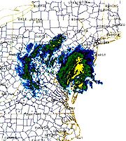
Tropical Storm Danielle was a weak tropical storm that made landfall on Virginia
in the 1992 Atlantic hurricane season
. The fourth storm of the season, Danielle was one of two Atlantic storms
in the year to make landfall in the United States
, the other being Hurricane Andrew
. It formed out of a stationary trough of low pressure on September 18 near the coast of North Carolina
. The system quickly reached tropical storm status, and Danielle looped to the west due to a change in steering currents. Tropical Storm Danielle reached a peak of 65 mph (105 km/h) winds before weakening and hitting the Delmarva Peninsula
. The storm quickly dissipated over land.
The storm dropped light rainfall throughout its path, and winds were minimal. The combination of Danielle and a high pressure system produced higher than normal tides and strong waves, causing beach erosion and light coastal damage. The waves killed two in New Jersey from a boat sinking, and also destroyed three houses in the Outer Banks
of North Carolina. Overall damage from the storm was minimal.
on September 18. On the same day, a weak tropical wave which moved off the coast of Africa
on September 8 approached the area. A cold front merged with the stationary area of disturbed weather on September 20, and on September 22 a circulation developed 200 miles (325 km) southeast of Cape Hatteras
, North Carolina
. Organization continued as outflow became better defined, and the system developed into Tropical Depression Six later that day.
The depression rapidly organized and attained tropical storm status with winds of 50 mph (80 km/h) just six hours after forming, upon which it was named Danielle
. In response to an approaching trough, Danielle initially moved to the northeast. However, the trough outran the system, and a developing high pressure system to its north resulted in Danielle executing a tight, anticyclonic loop on September 23 to the 24th. The storm strengthened as it turned to the northwest, and reached a peak of 65 mph (105 km/h) winds on September 25 while just off the northeastern coast of North Carolina. Danielle turned to the north-northwest, and made landfall on the Eastern Shore
of Virginia
late on the 25th. It rapidly weakened over land, and dissipated over eastern Pennsylvania
on September 26.
 Early in its life, forecasters had difficulties regarding the future track and intensity of Danielle, including a northeastward motion instead of its loop. After Danielle executed its loop, forecasters consistently predicted a landfall along the northeastern North Carolina
coastline. As a result, officials issued Tropical Storm Warnings
for the coast of North Carolina on September 24, 36 hours before the storm passed to the east of the state. The continued northward motion caught forecasters off guard, and consequentially tropical storm warnings were not issued for the Delmarva Peninsula
until just 12 hours before the storm made landfall. In addition, forecasters issued tropical storm warnings from Delaware
through Watch Hill, Rhode Island, as a precaution.
In North Carolina
, ferry operations between Ocracoke
and the mainland at Hyde County
were closed, while officials canceled schools in Dare County, North Carolina
due to the approaching storm. Several families voluntarily evacuated St. George's Island in southern St. Mary's County, Maryland. In addition, officials in Delaware
recommended evacuations for low-level areas and beaches. As a precaution, officials set up two shelters in Kent County
.
, peaking at 58 mph (93 km/h) at Alligator River Bridge
. Several other locations reported over tropical storm force winds. The pressure gradient also produced higher than normal waves along the coastline, with a maximum of 20 feet (6 m) at Duck. Despite passing close to the coastline, Danielle dropped only light rainfall, totaling to 0.2 inches (5 mm) at Cape Hatteras. However, locations in the central portion of the state experienced over 1 inch (25 mm) of rainfall.
Waves and high tides from the storm caused flooding along the Pamlico Sound
side of Ocracoke
and southern Hatteras Island
. High tides also resulted in overwash in Pea Island, forcing the closure of State Highway 17
due to 12 inches (305 mm) of salt water. High tides from the storm also destroyed two houses in South Nags Head and one in Rodanthe
, two of which were previously condemned after the 1991 Perfect Storm. Three other houses in the Outer Banks were threatened by the storm. Elsewhere in the Outer Banks, damage was minimal, and was limited to pedestrian ramps and steps to the beachfront.
 In Virginia
, Tropical Storm Danielle produced peak wind gusts of 61 mph (98 km/h) at Cape Henry
, though sustained winds remained below tropical storm strength. Rainfall was light along the coast, totaling to around 0.34 inches (8.6 mm). However, outer bands of the storm produced heavier rainfall in the center portion of the state, peaking at 4.09 inches (103.88 m) at Charlottesville
. The storm also produced higher than usual tides, peaking at 4.42 feet (1.3 m) at the mouth of the Elizabeth River
in Sewells Point
, as well as strong waves along the Virginia coastline. The waves caused significant overwash, leaving parts of Norfolk
under 2 feet (.6 m) of water. Several homes, businesses, and cars were flooded, as well. The waves also eroded beaches along the coast. Overall, damage was minimal, and there were no reports of deaths or injuries.
Upon making landfall Danielle produced an estimated storm tide of 2 to 3 feet (.6 to .9 m) in Ocean City
, Maryland
. Wind gusts peaked at 53 mph (85 km/h), also in Ocean City. The storm produced moderate rainfall of over 3 inches (76 mm) across the Eastern Shore of Maryland
, while interior amounts experienced slightly lesser amounts of up to 2.79 inches (71 mm) in Pasadena
. Waves from the storm caused minor to moderate beach erosion along the coastline, and the combination of waves and high tides caused moderate street flooding. Near Salisbury
, the storm produced a possible hook echo, though no tornadoes were reported. Danielle caused no deaths or injuries in the state.
In Delaware
, the storm dropped light precipitation, with a maximum amount of 3.75 inches (95 mm) in Smyrna
. Wind gusts peaked at 66 mph (106 km/h) at Cape Henlopen
. Danielle caused 2 to 3-foot (.6 to .9-m) higher than normal tides, along with strong waves. The combination of the two flooded some coastal houses and resulted in significant beach and dune erosion. The waves also sank four boats and washed away a dock near Slaughter Beach
. Gusty winds caused power outages in New Castle County
, while persistent rainfall caused sewer interruptions. Overall, with the exception of the severe beach erosion, damage was minimal.
, with some areas in the southwestern portion of the state experiencing over 3 inches (76 mm). Strong waves from the storm washed out miles of beaches along the coastline. In Ocean City
, the waves passed over the boardwalk and into houses. Further north, the waves crashed a four-person, 35-foot (10-m) sailboat near Island Beach State Park
. Two managed to swim safely to shore, though the other two occupants drowned.
Danielle's outer bands dropped light rainfall from Connecticut
through Maine
, with isolated locations in Rhode Island
and Massachusetts
reporting over 3 inches (76 mm). Damage in New England is unknown.
Virginia
The Commonwealth of Virginia , is a U.S. state on the Atlantic Coast of the Southern United States. Virginia is nicknamed the "Old Dominion" and sometimes the "Mother of Presidents" after the eight U.S. presidents born there...
in the 1992 Atlantic hurricane season
1992 Atlantic hurricane season
The 1992 Atlantic hurricane season had one of the latest dates on record for the first named storm. The season officially began on June 1, 1992, and lasted until November 30, 1992. It was the least active hurricane season in nine years due to a strong El Niño...
. The fourth storm of the season, Danielle was one of two Atlantic storms
Atlantic hurricane
North Atlantic tropical cyclones usually form in the northern hemisphere summer or fall. Tropical cyclones can be categorized by intensity. Tropical storms have one-minute maximum sustained winds of at least 39 mph , while hurricanes have one-minute maximum sustained exceeding 74 mph...
in the year to make landfall in the United States
United States
The United States of America is a federal constitutional republic comprising fifty states and a federal district...
, the other being Hurricane Andrew
Hurricane Andrew
Hurricane Andrew was the third Category 5 hurricane to make landfall in the United States, after the Labor Day Hurricane of 1935 and Hurricane Camille in 1969. Andrew was the first named storm and only major hurricane of the otherwise inactive 1992 Atlantic hurricane season...
. It formed out of a stationary trough of low pressure on September 18 near the coast of North Carolina
North Carolina
North Carolina is a state located in the southeastern United States. The state borders South Carolina and Georgia to the south, Tennessee to the west and Virginia to the north. North Carolina contains 100 counties. Its capital is Raleigh, and its largest city is Charlotte...
. The system quickly reached tropical storm status, and Danielle looped to the west due to a change in steering currents. Tropical Storm Danielle reached a peak of 65 mph (105 km/h) winds before weakening and hitting the Delmarva Peninsula
Delmarva Peninsula
The Delmarva Peninsula is a large peninsula on the East Coast of the United States, occupied by most of Delaware and portions of Maryland and Virginia...
. The storm quickly dissipated over land.
The storm dropped light rainfall throughout its path, and winds were minimal. The combination of Danielle and a high pressure system produced higher than normal tides and strong waves, causing beach erosion and light coastal damage. The waves killed two in New Jersey from a boat sinking, and also destroyed three houses in the Outer Banks
Outer Banks
The Outer Banks is a 200-mile long string of narrow barrier islands off the coast of North Carolina, beginning in the southeastern corner of Virginia Beach on the east coast of the United States....
of North Carolina. Overall damage from the storm was minimal.
Meteorological history
A surface trough of low pressure with an area of convection persisted off the southeast coast of the United StatesUnited States
The United States of America is a federal constitutional republic comprising fifty states and a federal district...
on September 18. On the same day, a weak tropical wave which moved off the coast of Africa
Africa
Africa is the world's second largest and second most populous continent, after Asia. At about 30.2 million km² including adjacent islands, it covers 6% of the Earth's total surface area and 20.4% of the total land area...
on September 8 approached the area. A cold front merged with the stationary area of disturbed weather on September 20, and on September 22 a circulation developed 200 miles (325 km) southeast of Cape Hatteras
Cape Hatteras
Cape Hatteras is a cape on the coast of North Carolina. It is the point that protrudes the farthest to the southeast along the northeast-to-southwest line of the Atlantic coast of North America...
, North Carolina
North Carolina
North Carolina is a state located in the southeastern United States. The state borders South Carolina and Georgia to the south, Tennessee to the west and Virginia to the north. North Carolina contains 100 counties. Its capital is Raleigh, and its largest city is Charlotte...
. Organization continued as outflow became better defined, and the system developed into Tropical Depression Six later that day.
The depression rapidly organized and attained tropical storm status with winds of 50 mph (80 km/h) just six hours after forming, upon which it was named Danielle
Danielle
Danielle is the French female variant of the male name Daniel, meaning "God is my judge" in the Hebrew language. The name appears in the Bible, where Daniel survives a night in a den of lions. The more common feminine version is "Daniella" or "Daniela" which is used in English, German, Italian and...
. In response to an approaching trough, Danielle initially moved to the northeast. However, the trough outran the system, and a developing high pressure system to its north resulted in Danielle executing a tight, anticyclonic loop on September 23 to the 24th. The storm strengthened as it turned to the northwest, and reached a peak of 65 mph (105 km/h) winds on September 25 while just off the northeastern coast of North Carolina. Danielle turned to the north-northwest, and made landfall on the Eastern Shore
Eastern Shore of Virginia
The Eastern Shore of Virginia consists of two counties on the Atlantic coast of the Commonwealth of Virginia in the United States. The region is part of the Delmarva Peninsula and is separated from the rest of Virginia by the Chesapeake Bay. Its population was 45,553 as of 2010...
of Virginia
Virginia
The Commonwealth of Virginia , is a U.S. state on the Atlantic Coast of the Southern United States. Virginia is nicknamed the "Old Dominion" and sometimes the "Mother of Presidents" after the eight U.S. presidents born there...
late on the 25th. It rapidly weakened over land, and dissipated over eastern Pennsylvania
Pennsylvania
The Commonwealth of Pennsylvania is a U.S. state that is located in the Northeastern and Mid-Atlantic regions of the United States. The state borders Delaware and Maryland to the south, West Virginia to the southwest, Ohio to the west, New York and Ontario, Canada, to the north, and New Jersey to...
on September 26.
Preparations
North Carolina
North Carolina is a state located in the southeastern United States. The state borders South Carolina and Georgia to the south, Tennessee to the west and Virginia to the north. North Carolina contains 100 counties. Its capital is Raleigh, and its largest city is Charlotte...
coastline. As a result, officials issued Tropical Storm Warnings
Tropical cyclone warnings and watches
Warnings and watches are two levels of alert issued by national weather forecasting bodies to coastal areas threatened by the imminent approach of a tropical cyclone of tropical storm or hurricane intensity. They are notices to the local population and civil authorities to make appropriate...
for the coast of North Carolina on September 24, 36 hours before the storm passed to the east of the state. The continued northward motion caught forecasters off guard, and consequentially tropical storm warnings were not issued for the Delmarva Peninsula
Delmarva Peninsula
The Delmarva Peninsula is a large peninsula on the East Coast of the United States, occupied by most of Delaware and portions of Maryland and Virginia...
until just 12 hours before the storm made landfall. In addition, forecasters issued tropical storm warnings from Delaware
Delaware
Delaware is a U.S. state located on the Atlantic Coast in the Mid-Atlantic region of the United States. It is bordered to the south and west by Maryland, and to the north by Pennsylvania...
through Watch Hill, Rhode Island, as a precaution.
In North Carolina
North Carolina
North Carolina is a state located in the southeastern United States. The state borders South Carolina and Georgia to the south, Tennessee to the west and Virginia to the north. North Carolina contains 100 counties. Its capital is Raleigh, and its largest city is Charlotte...
, ferry operations between Ocracoke
Ocracoke, North Carolina
Ocracoke is a census-designated place and unincorporated town located at the southern end of Ocracoke Island, located entirely within Hyde County, North Carolina. The population was 769 as of the 2000 census...
and the mainland at Hyde County
Hyde County, North Carolina
-National protected areas:* Alligator River National Wildlife Refuge * Cape Hatteras National Seashore * Mattamuskeet National Wildlife Refuge* Pocosin Lakes National Wildlife Refuge * Swanquarter National Wildlife Refuge-Demographics:...
were closed, while officials canceled schools in Dare County, North Carolina
Dare County, North Carolina
-National protected areas:* Alligator River National Wildlife Refuge * Cape Hatteras National Seashore * Fort Raleigh National Historic Site* Pea Island National Wildlife Refuge* Wright Brothers National Memorial-Demographics:...
due to the approaching storm. Several families voluntarily evacuated St. George's Island in southern St. Mary's County, Maryland. In addition, officials in Delaware
Delaware
Delaware is a U.S. state located on the Atlantic Coast in the Mid-Atlantic region of the United States. It is bordered to the south and west by Maryland, and to the north by Pennsylvania...
recommended evacuations for low-level areas and beaches. As a precaution, officials set up two shelters in Kent County
Kent County, Delaware
Kent County is a county located in the central part of the U.S. state of Delaware. It is coextensive with the Dover, Delaware, Metropolitan Statistical Area. As of 2010 the population was 162,310, a 28.1% increase over the previous decade. The county seat is Dover, the state capital...
.
North Carolina
The pressure gradient between Tropical Storm Danielle and a ridge of high pressure to its north produced moderately strong winds across eastern North CarolinaNorth Carolina
North Carolina is a state located in the southeastern United States. The state borders South Carolina and Georgia to the south, Tennessee to the west and Virginia to the north. North Carolina contains 100 counties. Its capital is Raleigh, and its largest city is Charlotte...
, peaking at 58 mph (93 km/h) at Alligator River Bridge
Alligator River National Wildlife Refuge
The Alligator River National Wildlife Refuge was established on March 14, 1984, to preserve and protect a unique wetland habitat type—the pocosin—and its associated wildlife species.The Refuge attracts visitors worldwide for its red wolf howling programs....
. Several other locations reported over tropical storm force winds. The pressure gradient also produced higher than normal waves along the coastline, with a maximum of 20 feet (6 m) at Duck. Despite passing close to the coastline, Danielle dropped only light rainfall, totaling to 0.2 inches (5 mm) at Cape Hatteras. However, locations in the central portion of the state experienced over 1 inch (25 mm) of rainfall.
Waves and high tides from the storm caused flooding along the Pamlico Sound
Pamlico Sound
Pamlico Sound in North Carolina, is the largest lagoon along the U.S. East Coast, being long and 24 to 48 km wide. It is a body of water separated from the Atlantic Ocean by the Outer Banks, a row of low, sandy barrier islands, including Cape Hatteras. The Neuse and Pamlico rivers flow in...
side of Ocracoke
Ocracoke, North Carolina
Ocracoke is a census-designated place and unincorporated town located at the southern end of Ocracoke Island, located entirely within Hyde County, North Carolina. The population was 769 as of the 2000 census...
and southern Hatteras Island
Hatteras Island
Hatteras Island is a barrier island located off the North Carolina coast. Dividing the Atlantic Ocean and the Pamlico Sound, it runs parallel to the coast, forming a bend at Cape Hatteras. It is part of North Carolina's Outer Banks and includes the towns of Rodanthe, Waves, Salvo, Avon, Buxton,...
. High tides also resulted in overwash in Pea Island, forcing the closure of State Highway 17
North Carolina State Highway 12
NC 12 is a North Carolina state highway that traverses the northeastern shoreline of North Carolina, linking the islands of the Outer Banks. It is a popular route for visitors touring the Outer Banks...
due to 12 inches (305 mm) of salt water. High tides from the storm also destroyed two houses in South Nags Head and one in Rodanthe
Rodanthe, North Carolina
Rodanthe is an unincorporated community located in Dare County, North Carolina, on Hatteras Island, part of North Carolina's Outer Banks. Rodanthe, along with Waves and Salvo, are part of the settlement of Chicamacomico...
, two of which were previously condemned after the 1991 Perfect Storm. Three other houses in the Outer Banks were threatened by the storm. Elsewhere in the Outer Banks, damage was minimal, and was limited to pedestrian ramps and steps to the beachfront.
Mid-Atlantic
Virginia
The Commonwealth of Virginia , is a U.S. state on the Atlantic Coast of the Southern United States. Virginia is nicknamed the "Old Dominion" and sometimes the "Mother of Presidents" after the eight U.S. presidents born there...
, Tropical Storm Danielle produced peak wind gusts of 61 mph (98 km/h) at Cape Henry
Cape Henry
Cape Henry is a cape on the Atlantic shore of Virginia north of Virginia Beach. It is the southern boundary of the entrance to Chesapeake Bay.Across the mouth of the bay to the north is Cape Charles...
, though sustained winds remained below tropical storm strength. Rainfall was light along the coast, totaling to around 0.34 inches (8.6 mm). However, outer bands of the storm produced heavier rainfall in the center portion of the state, peaking at 4.09 inches (103.88 m) at Charlottesville
Charlottesville, Virginia
Charlottesville is an independent city geographically surrounded by but separate from Albemarle County in the Commonwealth of Virginia, United States, and named after Charlotte of Mecklenburg-Strelitz, the queen consort of King George III of the United Kingdom.The official population estimate for...
. The storm also produced higher than usual tides, peaking at 4.42 feet (1.3 m) at the mouth of the Elizabeth River
Elizabeth River (Virginia)
The Elizabeth River is a tidal estuary forming an arm of Hampton Roads harbor at the southern end of Chesapeake Bay in southeast Virginia in the United States. It is located along the southern side of the mouth of the James River, between the cities of Portsmouth and Norfolk...
in Sewells Point
Sewell's Point
Sewells Point is a peninsula of land in the independent city of Norfolk, Virginia in the United States, located at the mouth of the salt-water port of Hampton Roads. Sewells Point is bordered by water on three sides, with Willoughby Bay to the north, Hampton Roads to the west, and the Lafayette...
, as well as strong waves along the Virginia coastline. The waves caused significant overwash, leaving parts of Norfolk
Norfolk, Virginia
Norfolk is an independent city in the Commonwealth of Virginia in the United States. With a population of 242,803 as of the 2010 Census, it is Virginia's second-largest city behind neighboring Virginia Beach....
under 2 feet (.6 m) of water. Several homes, businesses, and cars were flooded, as well. The waves also eroded beaches along the coast. Overall, damage was minimal, and there were no reports of deaths or injuries.
Upon making landfall Danielle produced an estimated storm tide of 2 to 3 feet (.6 to .9 m) in Ocean City
Ocean City, Maryland
Ocean City, sometimes known as OC, or OCMD, is an Atlantic Ocean resort town in Worcester County, Maryland, United States. Ocean City is widely known in the Mid-Atlantic region of the United States and is a frequent destination for vacationers in that area...
, Maryland
Maryland
Maryland is a U.S. state located in the Mid Atlantic region of the United States, bordering Virginia, West Virginia, and the District of Columbia to its south and west; Pennsylvania to its north; and Delaware to its east...
. Wind gusts peaked at 53 mph (85 km/h), also in Ocean City. The storm produced moderate rainfall of over 3 inches (76 mm) across the Eastern Shore of Maryland
Eastern Shore of Maryland
The Eastern Shore of Maryland is a territorial part of the U.S. state of Maryland that lies predominately on the east side of the Chesapeake Bay and consists of nine counties. The origin of term Eastern Shore was derived to distinguish a territorial part of the State of Maryland from the Western...
, while interior amounts experienced slightly lesser amounts of up to 2.79 inches (71 mm) in Pasadena
Pasadena, Maryland
Pasadena is a census-designated place in Anne Arundel County, Maryland, United States. The population was 12,093 at the 2000 census.-Geography:Pasadena is located at ....
. Waves from the storm caused minor to moderate beach erosion along the coastline, and the combination of waves and high tides caused moderate street flooding. Near Salisbury
Salisbury, Maryland
-Demographics:Salisbury is the principal city of the Salisbury-Ocean Pines CSA, a Combined Statistical Area that includes the Salisbury metropolitan area and the Ocean Pines micropolitan area , which had a combined population of 176,657 at the 2010 census.As of the census of 2000, there were...
, the storm produced a possible hook echo, though no tornadoes were reported. Danielle caused no deaths or injuries in the state.
In Delaware
Delaware
Delaware is a U.S. state located on the Atlantic Coast in the Mid-Atlantic region of the United States. It is bordered to the south and west by Maryland, and to the north by Pennsylvania...
, the storm dropped light precipitation, with a maximum amount of 3.75 inches (95 mm) in Smyrna
Smyrna, Delaware
Smyrna is a town in Kent and New Castle counties in the U.S. state of Delaware. It is part of the Dover, Delaware Metropolitan Statistical Area...
. Wind gusts peaked at 66 mph (106 km/h) at Cape Henlopen
Cape Henlopen
Cape Henlopen is the southern cape of the Delaware Bay along the Atlantic coast of the United States. It lies in the state of Delaware, near the town of Lewes, Delaware...
. Danielle caused 2 to 3-foot (.6 to .9-m) higher than normal tides, along with strong waves. The combination of the two flooded some coastal houses and resulted in significant beach and dune erosion. The waves also sank four boats and washed away a dock near Slaughter Beach
Slaughter Beach, Delaware
As of the census of 2000, there were 198 people, 108 households, and 64 families residing in the town. The population density was 147.9 people per square mile . There were 253 housing units at an average density of 189.0 per square mile...
. Gusty winds caused power outages in New Castle County
New Castle County, Delaware
New Castle County is the northernmost of the three counties of the U.S. state of Delaware. As of 2010 its population was 538,479, an increase of 7.6% over the previous decade. The county seat is Wilmington. The center of population of Delaware is located in New Castle County, in the town of...
, while persistent rainfall caused sewer interruptions. Overall, with the exception of the severe beach erosion, damage was minimal.
Northeast United States
Tropical Storm Danielle dropped light rainfall across much of New JerseyNew Jersey
New Jersey is a state in the Northeastern and Middle Atlantic regions of the United States. , its population was 8,791,894. It is bordered on the north and east by the state of New York, on the southeast and south by the Atlantic Ocean, on the west by Pennsylvania and on the southwest by Delaware...
, with some areas in the southwestern portion of the state experiencing over 3 inches (76 mm). Strong waves from the storm washed out miles of beaches along the coastline. In Ocean City
Ocean City, New Jersey
Ocean City is a city in Cape May County, New Jersey, United States. It is the principal city of the Ocean City Metropolitan Statistical Area which encompasses all of Cape May County. As of the 2010 United States Census, the city population was 11,701...
, the waves passed over the boardwalk and into houses. Further north, the waves crashed a four-person, 35-foot (10-m) sailboat near Island Beach State Park
Island Beach State Park
Island Beach State Park is a New Jersey state park located just south of Seaside Park on the Barnegat Peninsula in Berkeley Township, Ocean County, New Jersey, United States. The park is operated and maintained by the New Jersey Division of Parks and Forestry...
. Two managed to swim safely to shore, though the other two occupants drowned.
Danielle's outer bands dropped light rainfall from Connecticut
Connecticut
Connecticut is a state in the New England region of the northeastern United States. It is bordered by Rhode Island to the east, Massachusetts to the north, and the state of New York to the west and the south .Connecticut is named for the Connecticut River, the major U.S. river that approximately...
through Maine
Maine
Maine is a state in the New England region of the northeastern United States, bordered by the Atlantic Ocean to the east and south, New Hampshire to the west, and the Canadian provinces of Quebec to the northwest and New Brunswick to the northeast. Maine is both the northernmost and easternmost...
, with isolated locations in Rhode Island
Rhode Island
The state of Rhode Island and Providence Plantations, more commonly referred to as Rhode Island , is a state in the New England region of the United States. It is the smallest U.S. state by area...
and Massachusetts
Massachusetts
The Commonwealth of Massachusetts is a state in the New England region of the northeastern United States of America. It is bordered by Rhode Island and Connecticut to the south, New York to the west, and Vermont and New Hampshire to the north; at its east lies the Atlantic Ocean. As of the 2010...
reporting over 3 inches (76 mm). Damage in New England is unknown.
See also
- Other storms of the same nameHurricane DanielleThe name Danielle has been used for six tropical cyclones in the Atlantic Ocean:* Tropical Storm Danielle – flooded the area of Beaumont-Port Arthur, Texas* Tropical Storm Danielle – caused light damage to the Windward Islands...
- List of North Carolina hurricanes
- List of New Jersey hurricanes
- Timeline of the 1992 Atlantic hurricane seasonTimeline of the 1992 Atlantic hurricane seasonThe 1992 Atlantic hurricane season was a below-average season that produced six named tropical cyclones. The season officially started on June 1, 1992 and finished on November 30; however, Subtropical Storm One formed outside the official timeline on April 21...