

Coosa River
Encyclopedia
The Coosa River is a tributary of the Alabama River
in the U.S. state
s of Alabama
and Georgia
. The river is about 280 miles (450.6 km) long altogether.
The Coosa River is one of Alabama
's most developed rivers. It begins at the confluence
of the Oostanaula
and Etowah
rivers in Rome, Georgia
, and ends just northeast of the Alabama state capital, Montgomery
, where it joins the Tallapoosa River
to form the Alabama River
just south of Wetumpka
. Around 90% of the Coosa River's length is located in Alabama. Coosa County, Alabama
, is located on the Coosa River.
Most of the river has been impounded, with Alabama Power, a unit of the Southern Company
, maintaining seven power dams on the Coosa River. The hydroelectric power
dams have provided power to the citizens of Alabama, but are costly to some species endemic to the Coosa River.
Native Americans
had been living on the Coosa Valley for millennia before Hernando de Soto and his men became the first Europe
ans to discover it in 1540. The Coosa chiefdom
was one of the most powerful chiefdoms in the southeast at the time. Some have claimed that DeSoto mistreated the natives living in the area at the time, but most of this has been dismissed as political rhetoric.
Over a century after the Spanish
left the Coosa Valley, the British
established heavy trading ties with the tribes around the late 17th century, much to the dismay of France
. The French believed that the Coosa River was a key gateway to the entire South and they earnestly wanted to control the valley, since the main transportation of the day was by boat
. The convergence of the Coosa and Tallapoosa rivers was the gateway to Mobile Bay
, which was where the French docked coming and going from their home countries.
In the 18th century, almost all European and Indian trade in the southeast ceased during the tribal uprisings brought on by the Yamasee War
against the Carolinas
. After a few years, the Indian trade system was resumed under somewhat reformed policies. The conflict between the French and English over the Coosa Valley, and much of the southeast in general, continued. It wasn't until the Treaty of Paris
was signed in 1763, ending the French and Indian War
, that France relinquished its holdings east of the Mississippi River.
After the United States
won its independence, the Coosa Valley was home to the Creeks and the Cherokee
. After the Fort Mims massacre
, General Andrew Jackson
led American troops, along with Cherokee allies, against the Creeks in the Creek War
, which culminated in the Creek defeat at the Battle of Horseshoe Bend. Afterwards, the Treaty of Fort Jackson
in 1814 forced the cession of a large amount of land from the Creeks, but left them a reserve between the Coosa and Tallapoosa Rivers. Even there the Creeks were edged out by white settlers who had begun moving into the places which were not included in the nation. Finally, during the 1820s and 1830s the Creeks, Cherokee, and virtually all the southeastern Indians were removed to present-day Oklahoma
. The Cherokee removal is remembered as the Trail of Tears
. The Cherokee capital city of New Echota
was located on the headwater tributaries of the Coosa River, in Georgia, until the Cherokee removal. The Creek and Choctaw removals were similar to the Cherokee Trail of Tears. After the removals, the Coosa River valley and the southeast in general was wide open for American settlers. This, in conjunction with new cotton hybrids that could be grown inland, resulted in large-scale migrations known as "Alabama Fever".
The first river town to form in the Coosa Basin was at the foot of the last water falls on the Coosa River, the "Devil's Staircase", with the native name Wetumpka
(for "rumbling waters" or "falling stream") adopted shortly thereafter.
The Coosa River played an important role into the early 20th century as a commercial waterway for riverboat
s along the upper section of the river for 200 miles south of Rome. However, shoals and waterfalls such the Devil's Staircase along the river's lowest 65 miles blocked the upper Coosa's riverboats from access to the Alabama River and the Gulf of Mexico
.
The building of the dams on the Coosa—Lay, Mitchell and Jordan—allowed Alabama Power to pioneer new methods of controlling and eliminating malaria
which was a major health issue in rural Alabama in the early 1900s. So successful were their pioneering efforts in this area, that the Medical Division of the League of Nations
visited Alabama to study the new methods during the construction of Mitchell Dam.
For a time, the Popeye the Sailorman
cartoons were inspired by Tom Sims, a Coosa River resident familiar with riverboat life and characters of the early 1900s in Rome, Georgia.
(Picoides borealis), critically imperiled aquatic species (fish, mussels, and snails), southern hognose snake (Heterodon simus
), caddisflies, and imperiled plants. Maintaining the biodiversity of the Coosa River system is particularly important because it has already lost a significant portion of its aquatic fauna to extinction.
. The first four sections are tributary systems that converge to form the main artery of the Coosa River in Georgia. These main tributary rivers are the Conasauga and Coosawattee Rivers, which together then form the Oostanaula River. The Oostanaula then joins with the Etowah River in Rome, Georgia, forming the Coosa River.
Other significant tributaries of the Coosa are:
The Alabama Rivers Alliance works to unite the citizens of Alabama to protect peoples right to clean, healthy, waters.
Alabama Water Watch is dedicated to volunteer citizen monitoring of water quality in Alabama Rivers.
The Alabama Power Foundation is a non-profit foundation providing grants for watershed, environmental and community projects along the Coosa River and within the state of Alabama
The Coosa River Basin Initiative
is a grassroots environmental organization with the mission of informing and empowering citizens so that they may become involved in the process of creating a clean, healthy and economically viable Coosa River Basin.
Alabama River
The Alabama River, in the U.S. state of Alabama, is formed by the Tallapoosa and Coosa rivers, which unite about north of Montgomery.The river flows west to Selma, then southwest until, about from Mobile, it unites with the Tombigbee, forming the Mobile and Tensaw rivers, which discharge into...
in the U.S. state
U.S. state
A U.S. state is any one of the 50 federated states of the United States of America that share sovereignty with the federal government. Because of this shared sovereignty, an American is a citizen both of the federal entity and of his or her state of domicile. Four states use the official title of...
s of Alabama
Alabama
Alabama is a state located in the southeastern region of the United States. It is bordered by Tennessee to the north, Georgia to the east, Florida and the Gulf of Mexico to the south, and Mississippi to the west. Alabama ranks 30th in total land area and ranks second in the size of its inland...
and Georgia
Georgia (U.S. state)
Georgia is a state located in the southeastern United States. It was established in 1732, the last of the original Thirteen Colonies. The state is named after King George II of Great Britain. Georgia was the fourth state to ratify the United States Constitution, on January 2, 1788...
. The river is about 280 miles (450.6 km) long altogether.
The Coosa River is one of Alabama
Alabama
Alabama is a state located in the southeastern region of the United States. It is bordered by Tennessee to the north, Georgia to the east, Florida and the Gulf of Mexico to the south, and Mississippi to the west. Alabama ranks 30th in total land area and ranks second in the size of its inland...
's most developed rivers. It begins at the confluence
Confluence
Confluence, in geography, describes the meeting of two or more bodies of water.Confluence may also refer to:* Confluence , a property of term rewriting systems...
of the Oostanaula
Oostanaula River
The Oostanaula River is a principal tributary of the Coosa River, about long, in northwestern Georgia in the United States. Via the Coosa and Alabama rivers, it is part of the watershed of the Mobile River, which flows to the Gulf of Mexico. Its name is said to come from a Cherokee Indian term...
and Etowah
Etowah River
The Etowah River is a waterway that rises northwest of Dahlonega, Georgia, north of Atlanta. Its name is the Cherokee version of the original Muskogee word Etalwa, which means a "trail crossing". On Matthew Carey's 1795 map the river was labeled "High Town River"...
rivers in Rome, Georgia
Rome, Georgia
Located in the foothills of the Appalachian Mountains, Rome is the largest city and the county seat of Floyd County, Georgia, United States. It is the principal city of the Rome, Georgia Metropolitan Statistical Area which encompasses all of Floyd County...
, and ends just northeast of the Alabama state capital, Montgomery
Montgomery, Alabama
Montgomery is the capital of the U.S. state of Alabama, and is the county seat of Montgomery County. It is located on the Alabama River southeast of the center of the state, in the Gulf Coastal Plain. As of the 2010 census, Montgomery had a population of 205,764 making it the second-largest city...
, where it joins the Tallapoosa River
Tallapoosa River
The Tallapoosa River runs from the southern end of the Appalachian Mountains in Georgia, in the United States, southward and westward into Alabama. It is formed by the confluence of McClendon Creek and Mud Creek in Paulding County, Georgia. Lake Martin at Alexander City, Alabama is a large and...
to form the Alabama River
Alabama River
The Alabama River, in the U.S. state of Alabama, is formed by the Tallapoosa and Coosa rivers, which unite about north of Montgomery.The river flows west to Selma, then southwest until, about from Mobile, it unites with the Tombigbee, forming the Mobile and Tensaw rivers, which discharge into...
just south of Wetumpka
Wetumpka, Alabama
Wetumpka is a city in Elmore County, Alabama, United States. At the 2000 census the population was 5,726.The city is the county seat of Elmore County, one of the fastest growing counties in the state....
. Around 90% of the Coosa River's length is located in Alabama. Coosa County, Alabama
Coosa County, Alabama
Coosa County is a county of the U.S. state of Alabama. Its name derives from a town of the Creek tribe. As of 2010 the population was 11,539, but since that time it has lost the most population by percentage of any Alabama county...
, is located on the Coosa River.
Most of the river has been impounded, with Alabama Power, a unit of the Southern Company
Southern Company
Southern Company is a public utility holding company of primarily electric utilities in the southern United States. It is headquartered in Atlanta, Georgia with executive offices also located in Birmingham, Alabama. The company is currently the 16th largest utility company in the world and the...
, maintaining seven power dams on the Coosa River. The hydroelectric power
Hydroelectricity
Hydroelectricity is the term referring to electricity generated by hydropower; the production of electrical power through the use of the gravitational force of falling or flowing water. It is the most widely used form of renewable energy...
dams have provided power to the citizens of Alabama, but are costly to some species endemic to the Coosa River.
History
Native Americans
Native Americans in the United States
Native Americans in the United States are the indigenous peoples in North America within the boundaries of the present-day continental United States, parts of Alaska, and the island state of Hawaii. They are composed of numerous, distinct tribes, states, and ethnic groups, many of which survive as...
had been living on the Coosa Valley for millennia before Hernando de Soto and his men became the first Europe
Europe
Europe is, by convention, one of the world's seven continents. Comprising the westernmost peninsula of Eurasia, Europe is generally 'divided' from Asia to its east by the watershed divides of the Ural and Caucasus Mountains, the Ural River, the Caspian and Black Seas, and the waterways connecting...
ans to discover it in 1540. The Coosa chiefdom
Coosa chiefdom
The Coosa chiefdom was a powerful Native American paramount chiefdom near what are now Gordon and Murray counties in Georgia, in the United States. It was inhabited from about 1400 until about 1600, and dominated several smaller chiefdoms...
was one of the most powerful chiefdoms in the southeast at the time. Some have claimed that DeSoto mistreated the natives living in the area at the time, but most of this has been dismissed as political rhetoric.
Over a century after the Spanish
Spain
Spain , officially the Kingdom of Spain languages]] under the European Charter for Regional or Minority Languages. In each of these, Spain's official name is as follows:;;;;;;), is a country and member state of the European Union located in southwestern Europe on the Iberian Peninsula...
left the Coosa Valley, the British
United Kingdom
The United Kingdom of Great Britain and Northern IrelandIn the United Kingdom and Dependencies, other languages have been officially recognised as legitimate autochthonous languages under the European Charter for Regional or Minority Languages...
established heavy trading ties with the tribes around the late 17th century, much to the dismay of France
France
The French Republic , The French Republic , The French Republic , (commonly known as France , is a unitary semi-presidential republic in Western Europe with several overseas territories and islands located on other continents and in the Indian, Pacific, and Atlantic oceans. Metropolitan France...
. The French believed that the Coosa River was a key gateway to the entire South and they earnestly wanted to control the valley, since the main transportation of the day was by boat
Ship transport
Ship transport is watercraft carrying people or goods . Sea transport has been the largest carrier of freight throughout recorded history. Although the importance of sea travel for passengers has decreased due to aviation, it is effective for short trips and pleasure cruises...
. The convergence of the Coosa and Tallapoosa rivers was the gateway to Mobile Bay
Mobile Bay
Mobile Bay is an inlet of the Gulf of Mexico, lying within the state of Alabama in the United States. Its mouth is formed by the Fort Morgan Peninsula on the eastern side and Dauphin Island, a barrier island on the western side. The Mobile River and Tensaw River empty into the northern end of the...
, which was where the French docked coming and going from their home countries.
In the 18th century, almost all European and Indian trade in the southeast ceased during the tribal uprisings brought on by the Yamasee War
Yamasee War
The Yamasee War was a conflict between British settlers of colonial South Carolina and various Native American Indian tribes, including the Yamasee, Muscogee, Cherokee, Chickasaw, Catawba, Apalachee, Apalachicola, Yuchi, Savannah River Shawnee, Congaree, Waxhaw, Pee Dee, Cape Fear, Cheraw, and...
against the Carolinas
Province of Carolina
The Province of Carolina, originally chartered in 1629, was an English and later British colony of North America. Because the original Heath charter was unrealized and was ruled invalid, a new charter was issued to a group of eight English noblemen, the Lords Proprietors, in 1663...
. After a few years, the Indian trade system was resumed under somewhat reformed policies. The conflict between the French and English over the Coosa Valley, and much of the southeast in general, continued. It wasn't until the Treaty of Paris
Treaty of Paris (1763)
The Treaty of Paris, often called the Peace of Paris, or the Treaty of 1763, was signed on 10 February 1763, by the kingdoms of Great Britain, France and Spain, with Portugal in agreement. It ended the French and Indian War/Seven Years' War...
was signed in 1763, ending the French and Indian War
French and Indian War
The French and Indian War is the common American name for the war between Great Britain and France in North America from 1754 to 1763. In 1756, the war erupted into the world-wide conflict known as the Seven Years' War and thus came to be regarded as the North American theater of that war...
, that France relinquished its holdings east of the Mississippi River.
After the United States
United States
The United States of America is a federal constitutional republic comprising fifty states and a federal district...
won its independence, the Coosa Valley was home to the Creeks and the Cherokee
Cherokee
The Cherokee are a Native American people historically settled in the Southeastern United States . Linguistically, they are part of the Iroquoian language family...
. After the Fort Mims massacre
Fort Mims massacre
The Fort Mims massacre occurred on 30 August 1813, when a force of Creek people, belonging to the "Red Sticks" faction under the command of Peter McQueen and William Weatherford "Red Eagle", his cousin by marriage, killed hundreds of settlers, mixed-blood Creeks, and militia at Fort Mims...
, General Andrew Jackson
Andrew Jackson
Andrew Jackson was the seventh President of the United States . Based in frontier Tennessee, Jackson was a politician and army general who defeated the Creek Indians at the Battle of Horseshoe Bend , and the British at the Battle of New Orleans...
led American troops, along with Cherokee allies, against the Creeks in the Creek War
Creek War
The Creek War , also known as the Red Stick War and the Creek Civil War, began as a civil war within the Creek nation...
, which culminated in the Creek defeat at the Battle of Horseshoe Bend. Afterwards, the Treaty of Fort Jackson
Treaty of Fort Jackson
The Treaty of Fort Jackson was signed on August 9, 1814 at Fort Jackson near Wetumpka, Alabama following the defeat of the Red Stick resistance by United States allied forces at the Battle of Horseshoe Bend. It occurred on the banks of the Tallapoosa River near the present city of Alexander City,...
in 1814 forced the cession of a large amount of land from the Creeks, but left them a reserve between the Coosa and Tallapoosa Rivers. Even there the Creeks were edged out by white settlers who had begun moving into the places which were not included in the nation. Finally, during the 1820s and 1830s the Creeks, Cherokee, and virtually all the southeastern Indians were removed to present-day Oklahoma
Oklahoma
Oklahoma is a state located in the South Central region of the United States of America. With an estimated 3,751,351 residents as of the 2010 census and a land area of 68,667 square miles , Oklahoma is the 28th most populous and 20th-largest state...
. The Cherokee removal is remembered as the Trail of Tears
Trail of Tears
The Trail of Tears is a name given to the forced relocation and movement of Native American nations from southeastern parts of the United States following the Indian Removal Act of 1830...
. The Cherokee capital city of New Echota
New Echota
New Echota was the capital of the Cherokee Nation prior to their forced removal in the 1830s. New Echota is 3.68 miles north of present-day Calhoun, Georgia, and south of Resaca, Georgia. The site is a state park and an historic site....
was located on the headwater tributaries of the Coosa River, in Georgia, until the Cherokee removal. The Creek and Choctaw removals were similar to the Cherokee Trail of Tears. After the removals, the Coosa River valley and the southeast in general was wide open for American settlers. This, in conjunction with new cotton hybrids that could be grown inland, resulted in large-scale migrations known as "Alabama Fever".
The first river town to form in the Coosa Basin was at the foot of the last water falls on the Coosa River, the "Devil's Staircase", with the native name Wetumpka
Wetumpka, Alabama
Wetumpka is a city in Elmore County, Alabama, United States. At the 2000 census the population was 5,726.The city is the county seat of Elmore County, one of the fastest growing counties in the state....
(for "rumbling waters" or "falling stream") adopted shortly thereafter.
The Coosa River played an important role into the early 20th century as a commercial waterway for riverboat
Riverboat
A riverboat is a ship built boat designed for inland navigation on lakes, rivers, and artificial waterways. They are generally equipped and outfitted as work boats in one of the carrying trades, for freight or people transport, including luxury units constructed for entertainment enterprises, such...
s along the upper section of the river for 200 miles south of Rome. However, shoals and waterfalls such the Devil's Staircase along the river's lowest 65 miles blocked the upper Coosa's riverboats from access to the Alabama River and the Gulf of Mexico
Gulf of Mexico
The Gulf of Mexico is a partially landlocked ocean basin largely surrounded by the North American continent and the island of Cuba. It is bounded on the northeast, north and northwest by the Gulf Coast of the United States, on the southwest and south by Mexico, and on the southeast by Cuba. In...
.
The building of the dams on the Coosa—Lay, Mitchell and Jordan—allowed Alabama Power to pioneer new methods of controlling and eliminating malaria
Malaria
Malaria is a mosquito-borne infectious disease of humans and other animals caused by eukaryotic protists of the genus Plasmodium. The disease results from the multiplication of Plasmodium parasites within red blood cells, causing symptoms that typically include fever and headache, in severe cases...
which was a major health issue in rural Alabama in the early 1900s. So successful were their pioneering efforts in this area, that the Medical Division of the League of Nations
League of Nations
The League of Nations was an intergovernmental organization founded as a result of the Paris Peace Conference that ended the First World War. It was the first permanent international organization whose principal mission was to maintain world peace...
visited Alabama to study the new methods during the construction of Mitchell Dam.
For a time, the Popeye the Sailorman
Popeye
Popeye the Sailor is a cartoon fictional character created by Elzie Crisler Segar, who has appeared in comic strips and animated cartoons in the cinema as well as on television. He first appeared in the daily King Features comic strip Thimble Theatre on January 17, 1929...
cartoons were inspired by Tom Sims, a Coosa River resident familiar with riverboat life and characters of the early 1900s in Rome, Georgia.
Impoundments and sections
The following table describes the seven impoundments on the Coosa River from the south to north built by the Alabama Power Company as well as the tailwater section below Jordan Dam. Harvey H. Jackson III in his book Putting Loafing Streams To Work characterized the importance of the first Coosa River dams as follows:| Impoundment/Section | Description | Images |
|---|---|---|
| Jordan Dam Tailwater | The Jordan Dam Tailwater flows approximate 7.5 miles into Wetumpka, Alabama and is a combination of pools, shoals and rapids. Alabama Power currently maintains minimum flow releases from Jordan Dam for whitewater boating and aquatic enhancement of the Coosa and Alabama Rivers below the dam. This section of river is home to the infamous Moccasin Gap rapids, a class III whitewater. | 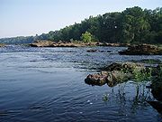 |
| Lake Jordan | Lake Jordan was impounded December 31, 1928 and named after the maiden name (Jordan) of the mother of Reuben and Sidney Mitchell, who were instrumental in the construction of Mitchell Dam on the Coosa River. The dam is 125 ft high and impounds 6800 acres (28 km²). Lake Jordan has a surface elevation of 252’ MSL and 180 miles of shoreline. The nearest town is Wetumpka, Alabama. It is an Alabama Power lake with an 100,000 Kilowatt generating capacity. Lake Jordan is an excellent recreational lake with fishing opportunities for largemouth bass Largemouth bass The largemouth bass is a species of black bass in the sunfish family native to North America . It is also known as widemouth bass, bigmouth, black bass, bucketmouth, Potter's fish, Florida bass, Florida largemouth, green bass, green trout, linesides, Oswego bass, southern largemouth... , spotted bass Spotted bass The Spotted Bass , also called "Spotty", "Leeman", or "Spots" in various fishing communities, is a species of freshwater fish sunfish family of order Perciformes. One of the black basses, it is native to the Mississippi River basin and across theGulf States, from central Texas through the Florida... , bluegill Bluegill The Bluegill is a species of freshwater fish sometimes referred to as bream, brim, or copper nose. It is a member of the sunfish family Centrarchidae of the order Perciformes.-Range and distribution:... and other sunfish, crappie Crappie Crappie is a genus of freshwater fish in the sunfish family of order Perciformes. The type species is P. annularis, the white crappie... , catfish Catfish Catfishes are a diverse group of ray-finned fish. Named for their prominent barbels, which resemble a cat's whiskers, catfish range in size and behavior from the heaviest and longest, the Mekong giant catfish from Southeast Asia and the second longest, the wels catfish of Eurasia, to detritivores... , striped bass Striped bass The striped bass is the state fish of Maryland, Rhode Island, South Carolina, and the state saltwater fish of New York, Virginia, and New Hampshire... , hybrid Striped bass The striped bass is the state fish of Maryland, Rhode Island, South Carolina, and the state saltwater fish of New York, Virginia, and New Hampshire... and white bass White bass The white bass or sand bass The white bass or sand bass The white bass or sand bass (MoroneIt is the state fish of Oklahoma.- Range :White bass are distributed widely across the United States, particularly in the midwest. They are very abundant in Pennsylvania and the area around Lake Erie... . It was the location of the 2004 Bass Masters Classic Tournament. The lake has two public access sites maintained by Alabama Power. |
 |
| Lake Bouldin | Impounded July 27, 1967 and named for Walter Bouldin, Bouldin is part of Lake Jordan and is connected to Lake Jordan and the Coosa River by two man made canals. Bouldin added 225,000 kilowatt generating power to the Lake Jordan system. On February 10, 1975, an earth embankment section of Walter Bouldin Dam was breached, causing total evacuation of the forebay reservoir and rendering the 225-MW power plant inoperable. | |
| Lake Mitchell | Lake Mitchell was impounded August 15, 1923 and named for James Mitchell, Alabama Power president from 1912 to 1920. The dam impounds 5850 acres (24 km²) and created a lake with 147 miles of shoreline. The nearest town is Clanton, Alabama Clanton, Alabama Clanton is a city in Chilton County, Alabama, United States. It is part of the Birmingham–Hoover–Cullman Combined Statistical Area. At the 2000 census the population was 7,800. The city is the county seat of Chilton County.-History:... . Lake Mitchell is an Alabama Power lake with an 170,000 kilowatt generating capacity. It is an excellent recreational lake with fishing opportunities for largemouth bass, spotted bass, bluegill and other sunfish, crappie, catfish, walleye, striped bass, hybrid and white bass. Alabama Power maintains three public access sites on the lake. |
 |
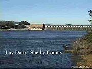
| Lay Lake | Lay Lake was impounded in 1914 and named after Captain William Patrick Lay, the first Alabama Power President. The dam impounds 12,000 acres (49 km²) with a shoreline of 289 miles. The nearest town is Columbiana, Alabama Columbiana, Alabama Columbiana is a city in Shelby County, Alabama, United States. At the 2010 census the population was 4,197. The city is the county seat of Shelby County.-History:... . Lay Lake is an Alabama Power lake with 177,000 kilowatt generating capacity. It is an excellent recreational lake with fishing opportunities for largemouth bass, spotted bass, bluegill and other sunfish, crappie, catfish, striped bass, hybrid and white bass. Alabama Power maintains seven public access sites on the lake. Lay Dam was one of the earliest concrete dams in the US and its construction helped pioneer dam building technology in the early 20th century. |
 |
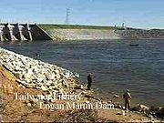
| Lake Logan Martin | Lake Logan Martin was impounded August 10, 1964 and named after William Logan Martin, Jr. He was a circuit court judge in Montgomery and also served as attorney general for the State of Alabama. The lake covers 15,263 acres (61.8 km²) and has 275 miles of shoreline. The nearest town is Pell City, Alabama Pell City, Alabama Pell City is a city in St. Clair County, Alabama, United States. The city is the county seat of St. Clair County along with Ashville. At the 2000 census the population was 9,565. At the 2010 census, the city-limit population jumped to 12,695. -Geography:... . Lake Logan Martin is an Alabama Power lake with an 128,250 Kilowatt annual generating capacity. It is an excellent recreational lake with fishing opportunities for largemouth bass, spotted bass, bluegill and other sunfish, crappie, catfish, striped bass, hybrid and white bass. Alabama Power maintains three public access sites on the lake. |
|
| Lake Neely Henry | Lake Neely Henry was impounded June 2, 1966 and named for H. Neely Henry, a senior executive vice-president of Alabama Power Company. The dam impounds 11,200 acres (45.3 km²) with 339 miles of shoreline. The nearest town is Ohatchee, Alabama Ohatchee, Alabama Ohatchee is a town in Calhoun County in Alabama, United States. At the 2000 census the population was 1,215. It is included in the Anniston-Oxford, Alabama Metropolitan Statistical Area.-Geography:... . Lake Neely Henry is an Alabama Power lake with an 72,900 kilowatt generating capacity. It is an excellent recreational lake with fishing opportunities for largemouth bass, spotted bass, bluegill and other sunfish, crappie, catfish, striped bass, hybrid and white bass. Alabama Power maintains three public access sites on the lake. |
 |
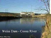
| Lake Weiss | Lake Weiss was impounded June 5, 1961 and named for F.C. Weiss, a former chief engineer of Alabama Power. The dam impounds a 30,200 acres (122 km²) lake with 447 miles of shoreline. The nearest town is Leesburg, Alabama Leesburg, Alabama Leesburg is a town in Cherokee County, Alabama, United States. At the 2000 census the population was 799.-Geography:Leesburg is located at 34°10'57.446" North, 85°46'8.350" West .According to the U.S... . Lake Weiss is an Alabama Power lake with an 87,750 kilowatt generating capacity. It is an excellent recreational lake with fishing opportunities for largemouth bass, spotted bass, bluegill and other sunfish, crappie, catfish, striped bass, hybrid and white bass. Weiss Lake is known for it excellent crappie fishing and often called the “Crappie Capital of the World”. Alabama Power maintains five Public Access sites on the lake. |
 |
Flora and fauna biodiversity highlights
In the Middle Coosa River Watershed, 281 occurrences of rare plant and animal species and natural communities have been documented, including 73 occurrences of 23 species that are federal or state protected. Ten conservation targets were chosen: the riverine system, matrix forest communities (oak hickory-pine forest), gray bat (Myotis grisescens), riparian vegetation, mountain longleaf pine (Pinus palustris) forest communities, red-cockaded woodpeckerRed-cockaded Woodpecker
The Red-cockaded Woodpecker is a woodpecker found in southeastern North America.- Description :About the size of the Northern Cardinal, it is approximately 8.5 in. long, with a wingspan of about 14 in. and a weight of about 1.5 ounces...
(Picoides borealis), critically imperiled aquatic species (fish, mussels, and snails), southern hognose snake (Heterodon simus
Heterodon simus
Heterodon simus is a harmless snake species found in the southeastern United States. No subspecies are currently recognized.-Description:Adults are 35.5-61 cm in length. Stout with a wide neck and a sharply upturned snout...
), caddisflies, and imperiled plants. Maintaining the biodiversity of the Coosa River system is particularly important because it has already lost a significant portion of its aquatic fauna to extinction.
| Category | Summary | Details (S)=State Status (F)=Federal Status |
|---|---|---|
| Aquatic gastropods (snails) | 82 species. According to research, 26 of the historically known 82 species of aquatic gastropods living in the Coosa River Basin, are now considered extinct!
|
Endangered, Threatened, and Rare Species |
| Amphibians | 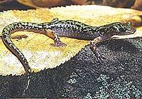 |
Endangered, Threatened, and Rare Species
Green salamander -Abstract:The Green Salamander is an extremely unique member of the lungless salamanders, Plethodontidae and is the only member of the Aneides genus that inhabits the Eastern United States... is "rare" in Georgia (S) |
| Fish | 87 species representing 17 families (13 of the fish species have been listed for protection by Federal or State agencies as endangered, threatened, or rare.)
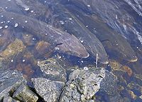 Lake sturgeon The lake sturgeon is a North American temperate freshwater fish, one of about 20 species of sturgeon. Like other sturgeons, this species is an evolutionarily ancient bottomfeeder with a partly cartilaginous skeleton and skin bearing rows of bony plates... (Acipenser fulvescens), a threatened species and once prevalent in the Coosa River system until the 1960s, is being re-introduced by the Georgia Department of Natural Resources. The Alabama Sturgeon, a former resident of the Coosa River below the fall line Fall line A fall line is a geomorphologic unconformity between an upland region of relatively hard crystalline basement rock and a coastal plain of softer sedimentary rock. A fall line is typically prominent when crossed by a river, for there will often be rapids or waterfalls... was placed on the endangered species list in September 2000 |
Endangered, Threatened, Rare and Invasive Species
|
| Mussels | Freshwater Mussels serve as natural filtration systems that help keep the water clean and clear. Georgia has 98 species of mussels laying its claim to the most diverse mussel fauna of the 50 states. Eleven species of these mussels native to the Coosa basin are currently listed or proposed for listing as endangered or threatened. 13 species are now extinct! Alabama has one of the richest and most diverse assemblages of mussels in the world with about 180 species. Approximately two-thirds of North American mussel species have been reported from Alabama. | Endangered, Threatened, and Rare Species |
| Plants | 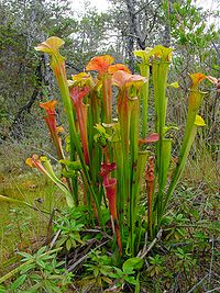 The upper Coosa watershed in northeastern Alabama and north Georgia is home to the majority of the remaining clumps of the endangered Green Pitcherplant Sarracenia oreophila Sarracenia oreophila, also known as the Green Pitcher Plant, is a carnivorous plant in the genus Sarracenia. It has highly modified leaves in the form of pitchers that act as pitfall traps for prey... . |
Endangered, Threatened, and Rare Species
|
| Reptiles | The southern hognose snake was a candidate species (C2) for listing as either threatened or endangered by the U.S. Fish and Wildlife Service (USFWS). However, the USFWS discontinued the designation of C2 species as candidates for listing (50 CFR 17; 28 February 1996). The southern hognose snake is considered to be a species of concern, but more biological research and field study are needed to resolve its conservation
status. |
Endangered, Threatened, and Rare Species
|
| Birds and mammals |  The Bald Eagle Bald Eagle The Bald Eagle is a bird of prey found in North America. It is the national bird and symbol of the United States of America. This sea eagle has two known sub-species and forms a species pair with the White-tailed Eagle... , once an endangered species now has nesting populations on and in the vicinity of Coosa River impoundments The largest concentration of clusters in Alabama of the Red-cockaded Woodpecker Red-cockaded Woodpecker The Red-cockaded Woodpecker is a woodpecker found in southeastern North America.- Description :About the size of the Northern Cardinal, it is approximately 8.5 in. long, with a wingspan of about 14 in. and a weight of about 1.5 ounces... , an endangered species, occurs on lands adjacent to Lake Mitchell under the stewardship of Alabama Power. |
Endangered, Threatened, and Rare Species
|
Tributaries
The Coosa River's drainage has hundreds of tributaries, which have been divided into sections based on the different areas of the watershedDrainage basin
A drainage basin is an extent or an area of land where surface water from rain and melting snow or ice converges to a single point, usually the exit of the basin, where the waters join another waterbody, such as a river, lake, reservoir, estuary, wetland, sea, or ocean...
. The first four sections are tributary systems that converge to form the main artery of the Coosa River in Georgia. These main tributary rivers are the Conasauga and Coosawattee Rivers, which together then form the Oostanaula River. The Oostanaula then joins with the Etowah River in Rome, Georgia, forming the Coosa River.
Other significant tributaries of the Coosa are:
- Amicalola Creek
- Armuchee Creek
- Big Wills Creek
- Cartecay River
- Cedar Creek
- Chattooga River
- Chocolocco Creek
- Coahulla River
- Ellijay River
- Hatchett Creek
- Heath Creek
- Little River
- Mill Creek
- Mountain Creek
- Raccoon Creek
- Rock Creek
- Spring Creek
- Sugar Creek
- Terrapin Creek
- Weogufka Creek (through Hatchett Creek)
| Location | Tributaries |
|---|---|
| Rome, GA to Weiss Dam | Cedar Creek, Chattooga River, Spring Creek, Cowan River, Little River, Yellow Creek |
| Weiss Dam to H. Neely Henry Dam | Ballplay Creek, Cove Creek, Henley Creek, Canoe Creek, Permita Creek, Green's Creek, Beaver Creek, Ottery Creek, Shoal Creek |
| H. Neely Henry Dam to Logan Martin Dam | Cheaha Creek |
| Logan Martin Dam to Lay Dam | Kelly Creek, Talladega Creek, Tallaseehatchee Creek, Dry Branch, Bulley Creek, Beeswax Creek, Flat Branch, Cedar Creek, Sulphur Creek, Peckerwood Creek, Spring Creek, Blue Springs Creek, Reid Creek, Coaggie Creek, Waxahatchee Creek, Paint Creek |
| Lay Dam to Mitchell Dam | Clay Creek, Walnut Creek, Hatchet Creek, Pennymotley Creek, Weougufka Creek, Cargile Creek, Blue Creek |
| Mitchell Dam to Jordan Dam | Chesnut Creek, Shoals Creek, Weoka Creek, Sofkahatchee Creek |
| Jordan Dam to Confluence of Tallapoosa River | Corn Creek |
Major cities
A number of significant cities lie on the banks of the Coosa River. They include:- Childersburg, AlabamaChildersburg, AlabamaChildersburg is a city in Talladega county in the U.S. state of Alabama. At the 2000 census the population was 4,927. It claims a history dating back before 1540, when it was noted as a village of the Coosa Nation visited by the Spanish explorer Hernando de Soto...
- near Lay Lake - Gadsden, AlabamaGadsden, AlabamaThe city of Gadsden is the county seat of Etowah County in the U.S. state of Alabama, and it is located about 65 miles northeast of Birmingham, Alabama. It is the primary city of the Gadsden Metropolitan Statistical Area, which has a population of 103,459. Gadsden is closely associated with the...
- between Weiss and H. Neely Henry lakes - Rainbow City, AlabamaRainbow City, AlabamaRainbow City is a city in Etowah County, Alabama, United States. It is part of the Gadsden Metropolitan Statistical Area.-Geography:Rainbow City is located at .According to the U.S...
- on the Coosa due south of Gadsden - Rome, GeorgiaRome, GeorgiaLocated in the foothills of the Appalachian Mountains, Rome is the largest city and the county seat of Floyd County, Georgia, United States. It is the principal city of the Rome, Georgia Metropolitan Statistical Area which encompasses all of Floyd County...
- headwaters - Southside, AlabamaSouthside, AlabamaSouthside is a city in Etowah county in the U.S. state of Alabama. It is part of the Gadsden Metropolitan Statistical Area. The population was 7,036 at the 2000 census...
- on the Coosa due south of Rainbow City - Wetumpka, AlabamaWetumpka, AlabamaWetumpka is a city in Elmore County, Alabama, United States. At the 2000 census the population was 5,726.The city is the county seat of Elmore County, one of the fastest growing counties in the state....
- near confluence with Tallapoosa River forming the Alabama River
Advocates
The Coosa-Alabama River Improvement Association, founded in 1890 in Gadsden, Alabama to promote navigation on the Coosa River is a leading advocate of the economic, recreational and environmental benefits of the Coosa River system.The Alabama Rivers Alliance works to unite the citizens of Alabama to protect peoples right to clean, healthy, waters.
Alabama Water Watch is dedicated to volunteer citizen monitoring of water quality in Alabama Rivers.
The Alabama Power Foundation is a non-profit foundation providing grants for watershed, environmental and community projects along the Coosa River and within the state of Alabama
The Coosa River Basin Initiative
Coosa river basin initiative
Coosa River Basin Initiative is a 501c3 grassroots environmental organization based in Rome, Georgia with the mission of informing and empowering citizens to protect, preserve and restore North America's most biologically diverse river basin, the Coosa...
is a grassroots environmental organization with the mission of informing and empowering citizens so that they may become involved in the process of creating a clean, healthy and economically viable Coosa River Basin.
See also
- List of rivers of Georgia (U.S. state)
- List of rivers of Alabama
- List of dams and reservoirs in Alabama