
Transportation in Houston
Encyclopedia
Roads and highways


Texas Department of Transportation
The Texas Department of Transportation is a governmental agency in the U.S. state of Texas. Its stated mission is to "work cooperatively to provide safe, effective and efficient movement of people and goods" throughout the state...
(TxDOT) planners have sought ways to reduce rush hour congestion, primarily through High-occupancy vehicle (HOV) lanes for vans and carpools. Timed freeway entrances, which regulate the addition of cars to the freeway, are also common. Houston has an extensive network of freeway cameras linked to a transit control center to monitor and study traffic. One characteristic of Houston's freeways (and Texas freeways in general) are its frontage road
Frontage road
A frontage road is a non-limited access road running parallel to a higher-speed road, usually a freeway, and feeding it at appropriate points of access...
s (which locals call "feeders"). Alongside most freeways are two to four lanes in each direction parallel to the freeway permitting easy access to individual city streets. Frontage roads provide access to the freeway from businesses alongside, such as gas stations and retail stores. New landscaping projects and a longstanding ban on new billboards are ways Houston has tried to control the potential side effects of convenience.
Houston has a hub-and-spoke
Spoke-hub distribution paradigm
The hub-and-spoke distribution paradigm is a system of connections arranged like a chariot wheel, in which all traffic moves along spokes connected to the hub at the center...
freeway structure with multiple loops. The innermost is Interstate 610
Interstate 610 (Texas)
Interstate 610 is a freeway that forms a forty-two-mile loop around the downtown sector of city of Houston, Texas. Interstate 610, colloquially known as "The Loop", "Loop 610", "The 610 Loop", or just "610", traditionally marks the border between the inner city of Houston and its surrounding areas...
, forming approximately a 10 miles (16.1 km) loop around downtown. The roughly square "Loop-610" is quartered into "North Loop," "South Loop," "West Loop," and "East Loop." The roads of Beltway 8
State Highway Beltway 8 (Texas)
Beltway 8 , the Sam Houston Parkway, along with the Sam Houston Tollway, is an beltway around the city of Houston, Texas, United States, lying entirely within Harris County. Beltway 8, a state highway, runs mostly along the frontage roads, only using the main lanes where they are free...
and their freeway core, the Sam Houston Tollway, are the next loop, at a diameter of roughly 25 miles. A proposed highway project, State Highway 99
State Highway 99 (Texas)
State Highway 99, also known as the Grand Parkway, is a Texas highway, which opened its first section in 1994. When State Highway 99 is complete, it will be the longest beltway in the world, and the third loop within the Houston–Sugar Land–Baytown metropolitan area, with Interstate 610 being...
(The Grand Parkway), would form a third loop outside of Houston, though some sections of this project have been controversial. As of 2007, the completed portion of State Highway 99 runs from just north of Interstate 10, west of Houston, to U.S. Highway 59 in Sugar Land
Sugar Land, Texas
Sugar Land is a city in the U.S. state of Texas within the metropolitan area and Fort Bend County. Sugar Land is one of the most affluent and fastest-growing cities in Texas, having grown more than 158 percent in the last decade. In the time period of 2000–2007, Sugar Land also enjoyed a...
, southwest of Houston, and was completed in 1994. The next portion to be constructed is from the current terminus at U.S. Highway 59 to State Highway 288
State Highway 288 (Texas)
State Highway 288, or SH 288, is a north–south highway in the southeastern portion of the U.S. state of Texas, between I-45 in downtown Houston and Freeport, where it terminates on FM 1495...
in Brazoria County
Brazoria County, Texas
Brazoria County[p] is a county in the U.S. state of Texas, located on the Gulf Coast within the Houston–Sugar Land–Baytown metropolitan area. Regionally, parts of the county are within the extreme southern-most fringe of the regions locally known as Southeast Texas. Brazoria County is among a...
.
Houston also lies along the route of the proposed Interstate 69 North American Free Trade Agreement
North American Free Trade Agreement
The North American Free Trade Agreement or NAFTA is an agreement signed by the governments of Canada, Mexico, and the United States, creating a trilateral trade bloc in North America. The agreement came into force on January 1, 1994. It superseded the Canada – United States Free Trade Agreement...
(NAFTA) superhighway that will link Canada, the U.S. industrial mid-west, Texas, and Mexico.
Mass transit

Metropolitan Transit Authority of Harris County, Texas
The Metropolitan Transit Authority of Harris County is a major public transportation agency based in Houston . It operates bus, light rail, future commuter rail, and paratransit service in the city as well as most of Harris County...
, or METRO, provides public transportation in the form of buses, trolleys, and lift vans.
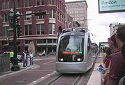
METRO began running light rail service (METRORail
METRORail
METRORail is the light rail line in Houston . It is the second major light rail service in Texas following the Dallas Area Rapid Transit system. With an approximate daily ridership of 34,155, the METRORail ranks as the fourteenth most-traveled light rail system in the United States, with the...
) on January 1, 2004. Currently the track runs approximately 8 miles (13 km) from Downtown Houston to the Texas Medical Center
Texas Medical Center
The Texas Medical Center is the largest medical center in the world with one of the highest densities of clinical facilities for patient care, basic science, and translational research...
and Reliant Park
Reliant Park
Reliant Park is a complex in Houston, Texas, USA, named after the energy company Reliant Energy. It is located on Kirby Drive at the 610 Loop...
. METRO operates an extensive park-and-ride bus system to serve many of Houston's outlying suburban areas. Most of the park-and-ride buses run in barrier-separated high-occupancy-vehicle (HOV) lanes that provide direct service from park-and-ride parking lots to major employment destinations. Prior to the opening of METRORail, Houston was the largest city in the United States without a rail transit system.
Following a successful referendum
Referendum
A referendum is a direct vote in which an entire electorate is asked to either accept or reject a particular proposal. This may result in the adoption of a new constitution, a constitutional amendment, a law, the recall of an elected official or simply a specific government policy. It is a form of...
held locally in 2003, METRO is currently in the beginning design phases of a 10-year expansion plan to add five more sections to connect to the current rail system. An 8.3 mile (13.4 km) expansion has been approved to run the service from the Uptown
Uptown Houston
The Uptown District of Houston is located 6.2 miles west of downtown and is centered along Post Oak Boulevard, Westheimer Road , and the Galleria...
through Texas Southern University
Texas Southern University
Texas Southern University is a historically black university located in Houston, Texas, United States....
, ending at the University of Houston
University of Houston
The University of Houston is a state research university, and is the flagship institution of the University of Houston System. Founded in 1927, it is Texas's third-largest university with nearly 40,000 students. Its campus spans 667 acres in southeast Houston, and was known as University of...
campus.
In addition, Harris County Transit
Harris County Transit
The Harris County Transit Services Division is a transportation agency that serves areas of Harris County, Texas that do not have service from Metropolitan Transit Authority of Harris County, Texas...
operates some services in the portion of Clear Lake City in Houston.
Airports within the city limits

George Bush Intercontinental Airport
George Bush Intercontinental Airport, is a Class B international airport in Houston, Texas, serving the Houston–Sugar Land–Baytown metropolitan area, the sixth-largest metropolitan area in the United States. Located north of Downtown Houston between Interstate 45 and U.S. Highway 59...
(IAH). The airport is the 7th-busiest in the United States for total passengers, and 16th busiest worldwide. Houston is the headquarters of Continental Airlines
Continental Airlines
Continental Airlines was a major American airline now merged with United Airlines. On May 3, 2010, Continental Airlines, Inc. and UAL, Inc. announced a merger via a stock swap, and on October 1, 2010, the merger closed and UAL changed its name to United Continental Holdings, Inc...
, Bush Intercontinental is Continental's largest hub, with more than 750 daily departures (more than 250 of which are Continental flights).
Bush Intercontinental currently ranks second in the United States for non-stop domestic and international service (221 destinations), trailing only Atlanta Hartsfield with 250 destinations. The United States Department of Transportation
United States Department of Transportation
The United States Department of Transportation is a federal Cabinet department of the United States government concerned with transportation. It was established by an act of Congress on October 15, 1966, and began operation on April 1, 1967...
has also recently named Bush Intercontinental one of the top ten fastest growing airports in the United States.
The second-largest commercial airport in Houston is the William P. Hobby Airport
William P. Hobby Airport
William P. Hobby Airport is a public airport in Houston, Texas, located from Downtown Houston. The airport covers and has four runways. Hobby Airport is Houston's oldest commercial airport and was the city's primary air terminal until the opening of Houston Intercontinental Airport in 1969...
(named Houston International Airport until 1967). The airport operates primarily small to medium-haul flights and is the only airport in Houston served by Southwest Airlines
Southwest Airlines
Southwest Airlines Co. is an American low-cost airline based in Dallas, Texas. Southwest is the largest airline in the United States, based upon domestic passengers carried,...
and JetBlue Airways
JetBlue Airways
JetBlue Airways Corporation is an American low-cost airline. The company is headquartered in the Forest Hills neighborhood of the New York City borough of Queens. Its main base is John F. Kennedy International Airport, also in Queens....
.
The third-largest airport and former U.S. Air Force base, Ellington Airport (formerly Ellington Field), is primarily used for government and private aircraft. At one point, Continental Express
Continental Express
Continental Express is the operating brand name used by a number of independently owned regional airlines providing regional jet feeder service under agreement with Continental Airlines...
operated flights across the city to Bush Intercontinental primarily for residents of southeast Houston and Galveston County. Passenger flights ended on September 7, 2004.
The Federal Aviation Administration
Federal Aviation Administration
The Federal Aviation Administration is the national aviation authority of the United States. An agency of the United States Department of Transportation, it has authority to regulate and oversee all aspects of civil aviation in the U.S...
and the state of Texas selected the Houston Airport System
Houston Airport System
Houston Airport System is a department of the City of Houston, Texas, United States that manages city airports. Its administrative offices are on the property of George Bush Intercontinental Airport. It operates Bush, William P. Hobby Airport, and Ellington Airport in Houston.The city of Houston...
, which manages Bush, Hobby, and Ellington, as Airport of the Year for 2005, largely because of its multi-year, $3.1 billion airport improvement program for both major airports in Houston.
Andrau Airpark
Andrau Airpark
Andrau Airpark was a public use airport located in the Alief community of Houston, Texas, United States, formerly an unincorporated section of Harris County, from the late 1940s through 1998. The airport was southeast of the intersection of Old Westheimer road and Richmond Avenue...
, a privately owned airport, was located in Houston until 1998; it was demolished and as of 2008 contains the Royal Oaks Country Club subdivision.
Publicly owned airports outside of the city limits
The following publicly owned airports are in the Houston area:- Harris County:
- La Porte Municipal AirportLa Porte Municipal Airport (Texas)La Porte Municipal Airport is a city-owned public-use airport located three miles northwest of the central business district of La Porte, a city in Harris County, Texas, United States.- Facilities and aircraft :...
in La PorteLa Porte, TexasLa Porte is a city in Harris County, Texas within the Bay Area of the Houston–Sugar Land–Baytown metropolitan area. As of the 2000 U.S. Census, the city population was 31,880... - Baytown AirportBaytown AirportBaytown Airport is a public-use airport located north of the central business district of Baytown, a city in Harris County, Texas, United States. It is privately-owned by Raceco Inc.- Facilities and aircraft :...
in unincorporated east Harris County, north of BaytownBaytown, TexasBaytown is a city within Harris County and partially in Chambers County in the Gulf Coast region of the U.S. state of Texas. Located within the Houston–Sugar Land–Baytown metropolitan area, it lies along both State Highway 146 and Interstate 10. As of 2010, Baytown had an population of 71,802...
- La Porte Municipal Airport
- Fort Bend County:
- Sugar Land Regional AirportSugar Land Regional AirportSugar Land Regional Airport is a city-owned public-use airport located in Sugar Land, Texas , southwest of the central business district of Houston....
in Sugar LandSugar Land, TexasSugar Land is a city in the U.S. state of Texas within the metropolitan area and Fort Bend County. Sugar Land is one of the most affluent and fastest-growing cities in Texas, having grown more than 158 percent in the last decade. In the time period of 2000–2007, Sugar Land also enjoyed a...
- Sugar Land Regional Airport
- Galveston County:
- Scholes International Airport at GalvestonScholes International Airport at GalvestonScholes International Airport at Galveston is an airport located in Galveston, Texas, United States. The airport, three miles southwest of downtown Galveston, has two runways.- Overview :...
, a general aviation and military airport, is located in GalvestonGalveston, TexasGalveston is a coastal city located on Galveston Island in the U.S. state of Texas. , the city had a total population of 47,743 within an area of...
- Scholes International Airport at Galveston
- Montgomery County:
- Lone Star Executive AirportLone Star Executive AirportLone Star Executive Airport is a county-owned public-use airport located in Conroe, Montgomery County, Texas, United States, 37 miles north of the central business district of Houston...
in ConroeConroe, TexasConroe is a suburban city 40 miles north of Houston in the gulf coastal plains/piney woods region of southeast Texas.It is the seat of Montgomery County and falls within the metropolitan area.As of the 2000 U.S...
- Lone Star Executive Airport
- Brazoria County:
- Brazoria County AirportBrazoria County AirportTexas Gulf Coast Regional Airport , previously known as Brazoria County Airport, is a county-owned public-use airport located four miles southwest of the central business district of Angleton and north of Lake Jackson, both cities in Brazoria County, Texas, United States.Although most U.S...
between Lake JacksonLake Jackson, TexasLake Jackson is a city in Brazoria County, Texas within the Houston–Sugar Land–Baytown metropolitan area. As of a 2006 U.S. Census Bureau estimate, the city population was 27,614....
and AngletonAngleton, TexasAngleton is a city in and the county seat of Brazoria County, Texas, United States, within the Houston–Sugar Land–Baytown metropolitan area. Angleton lies at the intersection of State Highway 288, State Highway 35, and the Union Pacific Railroad. The population was 18,130 at the 2000 census...
in an unincorporated area
- Brazoria County Airport
- Liberty County:
- Liberty Municipal AirportLiberty Municipal AirportLiberty Municipal Airport is a public use airport in Liberty County, Texas, United States. It is owned by the City of Liberty and is located six nautical miles northeast of its central business district.-Facilities and aircraft:...
is in LibertyLiberty, TexasLiberty is a city in and the county seat of Liberty County, Texas, United States and a part of the Houston-Sugar Land-Baytown metropolitan area. The population was 8,033 at the 2000 census....
. - Cleveland Municipal AirportCleveland Municipal Airport (Texas)Cleveland Municipal Airport is a general aviation airport located 4 miles northeast of Cleveland, Texas, United States.The designated Area Control Center is Houston Air Route Traffic Control Center.-External links:* *...
is in ClevelandCleveland, TexasCleveland is a city in Liberty County, Texas, United States. The population was 7,605 at the 2000 census.-History:In 1854, a church and convent was built by Father Peter La Cour near the town's present site...
.
- Liberty Municipal Airport
- Chambers County:
- Chambers County AirportChambers County AirportChambers County Airport is a county-owned general aviation airport located in unincorporated Chambers County, Texas, United States east of the city of Anahuac....
in an unincorporated area, east of AnahuacAnahuac, TexasAnahuac is a city in the U.S. state of Texas within the Houston–Sugar Land–Baytown metropolitan area. The population of the city was 2,210 at the 2000 census. Anahuac is the seat of Chambers County and is situated in East Texas.- History :... - Chambers County-Winnie Stowell AirportChambers County-Winnie Stowell AirportChambers County-Winnie Stowell Airport is a county-owned public-use airport located in Chambers County, Texas, United States. The airport is named after the unincorporated communities of Winnie and Stowell, both located east of the airport...
in an unincorporated area, near WinnieWinnie, TexasWinnie is a census-designated place in Chambers County, Texas, United States. The population was 2,914 at the 2000 census.-Geography:Winnie is located at . According to the United States Census Bureau, the CDP has a total area of , all of it land.-Historical development:The town plat was filed in...
and StowellStowell, TexasStowell is a census-designated place in Chambers County, Texas, United States The population was 1,572 at the 2000 census.-Geography:Stowell is located at ....
- Chambers County Airport
Privately owned airports outside of the city limits
The following privately owned airports for public use are in the Houston area:- Harris County
- West Houston AirportWest Houston AirportWest Houston Airport is a general aviation airport located in unincorporated western Harris County, Texas, United States, immediately west of the Houston city limits.The airport is located 13 miles west of Downtown Houston...
is a general aviation airport located in unincorporated western Harris County, west of the Houston city limits. - David Wayne Hooks Memorial AirportDavid Wayne Hooks Memorial AirportDavid Wayne Hooks Memorial Airport is a public-use airport located near the city of Tomball in unincorporated Harris County, Texas. It is northwest of the central business district of Houston...
, a general aviation airport, is located outside of the TomballTomball, TexasTomball is a city in Harris county in the U.S. state of Texas, a part of the Houston metropolitan area. The population was 9,089 at the 2000 census. In 1907, the community of Peck was renamed Tomball. The city are named for local congressman Thomas Henry Ball, who had a major role in the...
city limits in unincorporated northwest Harris County. - Weiser Air ParkWeiser Air ParkWeiser Air Park is a privately owned, public-use airport located on the Northwest Freeway in Cypress, an unincorporated area of Harris County, Texas, United States. The airport is 11 nautical miles northwest of the central business district of HoustonAlthough most U.S...
is in unincorporated northwest Harris County. - Sack-O-Grande AcroportSack-O-Grande AcroportSack-O-Grande Acroport , also known as the Harbican Airport is an airport in unincorporated Harris County, Texas, United States. It is located seven nautical miles north of the central business district of the city of Katy....
(also known as Harbican Airport) is located in an unincorporated area in western Harris County
- West Houston Airport
- Fort Bend County
- Houston Southwest AirportHouston Southwest AirportHouston Southwest Airport or Houston-Southwest Airport is a public-use airport located in Arcola, a city in Fort Bend County, Texas, United States, 15 miles southwest of the central business district of Houston. It is privately owned by James Griffith, Jr.Although most U.S...
in ArcolaArcola, TexasArcola is a city in Fort Bend County, Texas within the Houston–Sugar Land–Baytown metropolitan area. The population was 1,642 at the 2010 census.Arcola incorporated in 1986.-Geography:Arcola is located at .... - Westheimer Air ParkWestheimer Air ParkWestheimer Air Park is a privately-owned, public-use airport in unincorporated Fort Bend County, Texas, United States. The airport is 20 nautical miles west of the central business district of Houston...
in an unincorporated area - Happy Landings AirportHappy Landings AirportHouston Fort Bend Airport is a public-use airport located in unincorporated Fort Bend County, Texas, United States. The airport is located east of Beasley and southwest of the central business district of Houston. It is privately owned by John D. Hull, Jr...
in an unincorporated area
- Houston Southwest Airport
- Brazoria County
- Skyway Manor AirportSkyway Manor AirportSkyway Manor Airport is a public-use airport located three nautical miles west of the central business district of Pearland, a city in Brazoria County, Texas, United States. The airport is privately owned by Skyway Manor.- Facilities and aircraft :...
in PearlandPearland, TexasPearland , is a city located along the Gulf Coast region in the US state of Texas within the metropolitan area and is in the counties of Brazoria, Fort Bend, and Harris. As of the census of 2000, the city's population was 37,640. As of 2008, Pearland is estimated to have a population of 90,700... - Pearland Regional AirportPearland Regional AirportPearland Regional Airport is a public-use general aviation airport located in unincorporated Brazoria County, Texas, United States south of the city limits of Pearland and 17 miles south of the central business district of Houston. It is privately owned by the Clover Acquisition Corporation and...
(also known as Clover Field Airport) south of Pearland in an unincorporated area - Flyin' B AirportFlyin' B AirportFlyin' B Airport is an airport located in unincorporated Brazoria County, Texas, United States. The airport is located near Pearland.The airport is privately owned by Ned Lewis Beaman....
in an unincorporated area
- Skyway Manor Airport
- Chambers County
- RWJ AirparkRWJ AirparkRWJ Airpark is a public-use airport located in Beach City, Chambers County, Texas, United States, seven miles east of the central business district of Baytown. It is privately-owned by the R. W. Johnson Const. Co...
in Beach CityBeach City, TexasBeach City is a city in Chambers County, Texas, United States. The population was 1,645 at the 2000 census.-Geography:Beach City is located at ....
- RWJ Airpark
- Waller County
- Houston Executive AirportHouston Executive AirportHouston Executive Airport is a public-use airport in unincorporated Waller County, Texas, United States. The airport is located 28 nautical miles west of Downtown Houston. and it is in proximity to Brookshire. The airport is privately owned by WCF, LLC, which is based in Waller County.Although...
is located in an unincorporated area - Skydive Houston AirportSkydive Houston AirportSkydive Houston Airport is a privately owned, private airport located in unincorporated Waller County, Texas, United States. It is four nautical miles south of the central business district of Waller and is northwest of Houston...
(Skylake Airport) is located in an unincorporated area
- Houston Executive Airport
Air traffic control center
The Houston Air Route Traffic Control CenterHouston Air Route Traffic Control Center
Houston Air Route Traffic Control Center is located at George Bush Intercontinental Airport at 16600 JFK Boulevard, Houston, Texas, United States 77032...
stands on the George Bush Intercontinental Airport grounds.
Intercity rail

Amtrak
The National Railroad Passenger Corporation, doing business as Amtrak , is a government-owned corporation that was organized on May 1, 1971, to provide intercity passenger train service in the United States. "Amtrak" is a portmanteau of the words "America" and "track". It is headquartered at Union...
, the national rail passenger system, provides service to Houston via the (Los Angeles–New Orleans), which stops at the Houston Station
Houston (Amtrak station)
The Houston Amtrak station is a train station in Houston, Texas, United States served by Amtrak, the U.S. national railroad passenger system.Of the 19 Texas stations served by Amtrak, Houston was the sixth-busiest in FY2010, boarding or detraining an average of approximately 50 passengers daily.The...
on the north side of the Downtown area. The station saw 10,855 boardings and alightings in FY 2006.
Intercity bus
Greyhound Lines
Greyhound Lines, Inc., based in Dallas, Texas, is an intercity common carrier of passengers by bus serving over 3,700 destinations in the United States, Canada and Mexico, operating under the well-known logo of a leaping greyhound. It was founded in Hibbing, Minnesota, USA, in 1914 and...
operates services from five train stations:
- Houston Greyhound Station at 2121 South Main Street http://www.greyhound.com/scripts/en/TicketCenter/terminal.asp?city=681440
- Coach USA Inc. Dept. Casin (Houston Crosstimbers) at 4001 North Freeway http://www.greyhound.com/scripts/en/TicketCenter/terminal.asp?city=680142
- The Box Store (Houston Northwest) at 1500 West Loop North Suite 117 http://www.greyhound.com/scripts/en/TicketCenter/terminal.asp?city=683353
- Americanos U.S. L.L.C. (Houston Southeast) at 7000 Harrisburg Street http://www.greyhound.com/scripts/en/TicketCenter/terminal.asp?city=680098
- Agencia Autobuses (Houston Southwest) at 6590 Southwest Freeway
In addition, Greyhound operates services from two stops http://www.greyhound.com/scripts/en/TicketCenter/locations.asp?state=tx:
- Houston Aau
- HoustonHouston (Amtrak station)The Houston Amtrak station is a train station in Houston, Texas, United States served by Amtrak, the U.S. national railroad passenger system.Of the 19 Texas stations served by Amtrak, Houston was the sixth-busiest in FY2010, boarding or detraining an average of approximately 50 passengers daily.The...
(AmtrakAmtrakThe National Railroad Passenger Corporation, doing business as Amtrak , is a government-owned corporation that was organized on May 1, 1971, to provide intercity passenger train service in the United States. "Amtrak" is a portmanteau of the words "America" and "track". It is headquartered at Union...
station)
Greyhound also operates services to stops within the Greater Houston
Greater Houston
Houston–Sugar Land–Baytown is a 10-county metropolitan area defined by the Office of Management and Budget. It is located along the Gulf Coast region in the U.S. state of Texas...
area, including:
- AlvinAlvin, TexasAlvin is a city in the U.S. state of Texas within the Houston–Sugar Land–Baytown metropolitan area and Brazoria County. As of the 2000 U.S. Census, the city population was 21,413. Alvin's claim to fame is Baseball Hall of Famer Nolan Ryan, who moved with his family to the city in 1947 as...
(Yellow Jacket Grocery-CitgoCitgoCITGO Petroleum Corporation is a United States-incorporated, Venezuela-owned refiner, transporter and marketer of transportation fuels, lubricants, petrochemicals and other industrial products. The company is owned by PDV America, Inc., an indirect wholly owned subsidiary of Petróleos de...
) http://www.greyhound.com/scripts/en/TicketCenter/terminal.asp?city=680097 - AngletonAngleton, TexasAngleton is a city in and the county seat of Brazoria County, Texas, United States, within the Houston–Sugar Land–Baytown metropolitan area. Angleton lies at the intersection of State Highway 288, State Highway 35, and the Union Pacific Railroad. The population was 18,130 at the 2000 census...
(Ocampos Mexican Rest) http://www.greyhound.com/scripts/en/TicketCenter/terminal.asp?city=683540 - BaytownBaytown, TexasBaytown is a city within Harris County and partially in Chambers County in the Gulf Coast region of the U.S. state of Texas. Located within the Houston–Sugar Land–Baytown metropolitan area, it lies along both State Highway 146 and Interstate 10. As of 2010, Baytown had an population of 71,802...
(Baytown Travel Express) http://www.greyhound.com/scripts/en/TicketCenter/terminal.asp?city=688567 - ConroeConroe, TexasConroe is a suburban city 40 miles north of Houston in the gulf coastal plains/piney woods region of southeast Texas.It is the seat of Montgomery County and falls within the metropolitan area.As of the 2000 U.S...
(Conroe Greyhound Station) http://www.greyhound.com/scripts/en/TicketCenter/terminal.asp?city=680669 - GalvestonGalveston, TexasGalveston is a coastal city located on Galveston Island in the U.S. state of Texas. , the city had a total population of 47,743 within an area of...
(Galveston Bus Station) http://www.greyhound.com/scripts/en/TicketCenter/terminal.asp?city=681208 - KatyKaty, TexasKaty is a city located in Harris, Fort Bend and Waller Counties in the U.S. state of Texas, within the Houston–Sugar Land–Baytown metropolitan area...
(at Millers ExxonExxonExxon is a chain of gas stations as well as a brand of motor fuel and related products by ExxonMobil. From 1972 to 1999, Exxon was the corporate name of the company previously known as Standard Oil Company of New Jersey or Jersey Standard....
) http://www.greyhound.com/scripts/en/TicketCenter/terminal.asp?city=681550 - Prairie ViewPrairie View, TexasPrairie View is a city in Waller County, Texas, United States. The population was 4,410 at the 2000 census.Prairie View A&M University is located in the city.-Geography:Prairie View is located at ....
(at Unco Food Store) http://www.greyhound.com/scripts/en/TicketCenter/terminal.asp?city=682363 - RosenbergRosenberg, TexasRosenberg is a city located in the U.S. state of Texas within Fort Bend County and is part of the Houston–Sugar Land–Baytown metropolitan area. The population was 31,676 at the 2010 census...
(at ShellRoyal Dutch ShellRoyal Dutch Shell plc , commonly known as Shell, is a global oil and gas company headquartered in The Hague, Netherlands and with its registered office in London, United Kingdom. It is the fifth-largest company in the world according to a composite measure by Forbes magazine and one of the six...
-McDonalds) http://www.greyhound.com/scripts/en/TicketCenter/terminal.asp?city=682495 - SealySealy, TexasSealy is a city in Austin County, Texas within the Houston–Sugar Land–Baytown metropolitan area. The population was 5,248 at the 2000 census. Sealy is located 50 miles west of the downtown Houston area.-Geography:...
(at Mazac Muffler City-AC) http://www.greyhound.com/scripts/en/TicketCenter/terminal.asp?city=682638 - Texas CityTexas City, TexasTexas City is a city in Chambers and Galveston counties in the U.S. state of Texas. The population was 41,521 at the 2000 census. It is a part of the Houston–Sugar Land–Baytown, Texas Metropolitan Statistical Area.-History:...
(at McKown Air Conditioning, also serving La MarqueLa Marque, TexasLa Marque is a city in the U.S. state of Texas within the Houston–Sugar Land–Baytown metropolitan area. As of the 2010 U.S. Census, the city population was 14,509...
) http://www.greyhound.com/scripts/en/TicketCenter/terminal.asp?city=682935
Kerrville Bus Company http://www.kervillebus.com/ operates from the Houston Greyhound Station in conjunction with Greyhound.
El Expreso Bus Company http://www.elexpreso.net/english.php operates services to a station in Houston adjacent to the Greyhound Station.
Tornado Bus Company operates services to two stations in Houston http://tornadobus.com/houston.html, with one along Airline Drive and one along Harrisburg.
In the 1990s various bus companies began operations in the East End, serving Mexico and other parts of the United States from East End terminals.
Intercity bus to airport
VivaAerobus, a Mexican airline, operated a bus shuttle between Austin-Bergstrom International AirportAustin-Bergstrom International Airport
Austin-Bergstrom International Airport is a mixed-use commercial airport located southeast of the central business district of Austin, Texas, United States. It covers and has two runways and three helipads.The airport began passenger service on May 23, 1999...
South Terminal and the Omnibus Mexicanos Bus Terminal in eastern Houston for VivaAerobus passengers on flights going to and from Cancun and Monterrey. On May 16, 2009, VivaAerobus stated it would cease passenger operations at Austin-Bergstrom International Airport on May 31, 2009. The airline blamed the pullout in part on the outbreak of the swine flu, which caused an unprecedented decrease in demand for service.
Pedestrian travel
Texas Department of TransportationTexas Department of Transportation
The Texas Department of Transportation is a governmental agency in the U.S. state of Texas. Its stated mission is to "work cooperatively to provide safe, effective and efficient movement of people and goods" throughout the state...
statistics said that in an eight county area including Houston, between 2003 and 2008, around 100 pedestrians died and 1,175 were injured in accidents every year. Mark Seegers, a spokesperson for Harris County commissioner Sylvia Garcia, said in 2009 that "The county does not do sidewalks; it’s not what gets cars [the predominate form of transportation in the Houston area] from point A to point B." Robin Holzer, a transportation advocate with the Citizens' Transportation Coalition, criticized the emphasis on automobiles, saying "The people on foot and bike are trying to go to the same schools and restaurants and shops as people in cars are going to."
In 2005 the Houston-Galveston Area Council identified several communities in Harris County considered to be among the most hazardous to pedestrians. Many of them, including Greenspoint and Gulfton, are located outside of the 610 Loop. In 2009 the lobby group Transportation for America said that the Houston area was the eighth most dangerous area for pedestrians in 2007-2008.
Demographics by mode of travel
Dan Felstein and Claudia Kolker of the Houston ChronicleHouston Chronicle
The Houston Chronicle is the largest daily newspaper in Texas, USA, headquartered in the Houston Chronicle Building in Downtown Houston. , it is the ninth-largest newspaper by circulation in the United States...
said in 1997 that most Houstonians who take public transportation are poor. A 1995 survey concluded that 76% of people riding on local bus lines of the Metropolitan Transit Authority of Harris County (METRO) took the buses because they had no other means of transportation. A 1993 survey concluded that of the people who had stopped riding local bus routes of METRO, 46% had acquired or repaired automobiles. 37% of the respondents said that METRO could not possibly do anything to convince them to ride the buses again.
As of U.S. Census figures current as of 1997, 9% of residents in Harris County did not own automobiles. This figure does not include people who own cars, but do not have enough money to repair the automobiles. As of that year, while the average income of all residents of the county was $41,000, the average income of households without cars was $13,000.
In Harris County, the average one way commute for a person using an automobile was 25 minutes, while the average commute for a person not using an automobile was 44 minutes, a 76% longer duration than the figure for commuters with cars.
As of 1997 many poor people and immigrants rely on bicycles, entrepreneurs, family members, and neighbors for transportation. Dan Feldstein and Claudia Kolker of the Houston Chronicle
Houston Chronicle
The Houston Chronicle is the largest daily newspaper in Texas, USA, headquartered in the Houston Chronicle Building in Downtown Houston. , it is the ninth-largest newspaper by circulation in the United States...
said that "ironically, some of the poorest Houstonians have wider transportation options than their middle-class counterparts."
See also
- Houston Highway Construction