

Transport in Bristol
Encyclopedia
Bristol
is a city in south west England
, situated near the Bristol Channel
coast, approximately 115 miles (185 km) west of London
. Several factors have influenced the development of its transport network. It is a major centre of employment, retail, culture and higher education, has many historic areas, and has a history of maritime industry. The city has a population of 400,000, with a metropolitan area
of 550,000, and lies at the centre of the former County of Avon
, which includes many dormitory towns, and has a population of one million. Additionally, it has the seventh highest population density of any English district.
(BRS), at Lulsgate, which has seen substantial improvements to its runway, terminal and other facilities. The airport offers services to major European destinations, but the service to Newark Airport
near New York City
was withdrawn in November 2010.
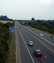
The city is connected by road on an east-west axis from London to Wales
by the M4 motorway
, and on a north-southwest axis from Birmingham
to Exeter by the M5 motorway
. Also within the county is the M49 motorway
, a shortcut between the M5 in the south and M4 Severn Crossing
in the west.
.jpg) There are two principal railway stations in Bristol they are Bristol Parkway
There are two principal railway stations in Bristol they are Bristol Parkway
and Bristol Temple Meads
. There are also scheduled coach links to most major UK cities.
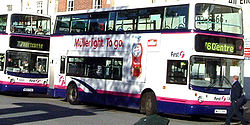
within the city is still largely bus
-based, with Bristol Bus Station
being located in Marlborough Street, near the Broadmead
shopping area. The majority of the local bus service is operated by First Group. The central part of the city also has water-based routes, operated as the Bristol Ferry Boat
, which provide both leisure and commuter services on the harbour. Bristol has over 50 bus and coach services operating in the city, providing links not just around the city but also rail links, park and rides and links to other major UK cities. The majority of the local bus services are operated by First Group.
Bristol has never been well served by suburban railways
, though the Severn Beach Line
to Avonmouth
and Severn Beach
survived the Beeching Axe
and is still in operation today - in 2006 funding was secured to improve the frequency of services on this line from late 2007. The Portishead Railway
was closed in the Beeching Axe but was relaid between 2000-2002 as far as the Royal Portbury Dock
with a Strategic Rail Authority
rail-freight grant. Plans to relay a further three miles of track to Portishead, a largely dormitory town with only one connecting road, have been discussed but there is insufficient funding to rebuild stations.
The Bristol Ferry Boat operates passenger ferry boat services on Bristol Harbour in the centre of Bristol. Services are operated both for the leisure market and for commuters to and from both the city centre and Bristol Temple Meads railway station
, and serve 15 landing stages throughout the length of the harbour. Services are provided by a fleet of historic, yellow painted ferry boats. The north of the city is served by Bristol Parkway railway station
.
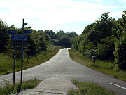
 The A4174 "Avon ring road"
serves as a relief road for parts of the northern, eastern, and southern suburbs of the city. During 2006 plans have been considered to extend the existing A4174 ring road to improve transport links in the south.
Bristol city centre
was, until the 1990s, surrounded by a ring road
. This has since been partially dismantled, but major routes still converge on the city centre. Radiating from this are several major arterial roads. The M32 motorway
, constructed in the late 1960s, runs north from the centre to the M4, and is the busiest route. The A4 runs east to Keynsham
and Bath, and west through the Avon Gorge
to the M5 at Avonmouth
. The northern suburbs are served by the A4018
and A38 "Gloucester Road"
, the east by the A420
, A431
and A432
and the south by the A37 and A38. Several other commuter towns also lie on major routes radiating from the city, including Weston-super-Mare
on the A370
and Portishead
on the A369
.
 Despite being hilly, Bristol is one of the prominent cycling cities of England. Bristol is home to the national cycle campaigning group Sustrans
. It has a number of urban cycle routes, as well as links to National Cycle Network
routes to Bath and London, to Gloucester and Wales, and to the south-western peninsula of England. 4.6% of journeys to work are by bicycle. Between 1991 and 2001 Bristol had the third highest increase in bicycle use of any UK council area, at 1.64%. Following the 2001 Local Transport Plan cycling increased even more rapidly, with a 21% increase in journeys.
Bristol was recently awarded £22.8 million to double its cycling population after being awarded "cycling city" status. More information can be found at the region's cycling website Better By Bike
friendly city. The city council recognises that motorcycle use eases congestion as motorcycles take up less space both on the road and when parked. Its motorcycling policy includes the following:
and Portishead, which have good connections to the M5, but poor public transport systems, contribute to the congestion, and have growing populations.
 Bristol's bus service, run by First Group, has been a regular target of criticism. The University of the West of England
Student's Union described First Bus as "unsatisfactory" and "untenable", while the 2006 Local Transport Plan describes public transport in Bristol as unattractive and expensive. Bristol East
MP
, Kerry McCarthy
, has stated that attempts to get motorists onto public transport will fail when, as in Bristol, providers repeatedly put fares up above the rate of inflation. In 2005 the company was fined £96,250 for delays, and nearly lost a sixth of its vehicle licenses due to poor maintenance. First Group in Bristol have a target 95% punctuality (maximum five minutes late), but in January-February 2008, punctuality was 83.9%, and reliability 97.5%.
In addition to problems with local public transport, the main local rail franchise, First Great Western
, has a poor record of punctuality, with only 71% of trains reaching their destinations on time. In January 2007 and January 2008, fare strikes were organised, during which fake tickets were issued to passengers during morning commutes.. There are no suburban rail links into the actual centre of Bristol, and those that do go near to it have infrequent services . This means that rail-travel is not widely used for in-city transport.
system in its Local Transport Plan
, but has so far been unable to fund the project. The city was offered European Union
funding for the system, but the Department for Transport
did not provide the required additional funding.
As well as improvements to public transport, the 2005 Greater Bristol Strategic Transport Study, commissioned by the regional government office
, recommended road building to tackle congestion. These include re-routing and extended the South Bristol Ring Road. The road is currently partially single carriageway and indirect, terminating at the A38 in a built-up area. When the current sections of the road were built it was intended that the road would continue as dual carriageway to a section of the A38 further south, and development prevented on the intended route. The proposals follow this route west from Hengrove Park roundabout to the A38 at Castle Farm (phase 1), and from there to the A370 near Long Ashton Park and Ride (phase 2). There are additional recommendations (phase 3) for a new Whitchurch
bypass from Hengrove Park roundabout, along the base of Dundry Hill
, around Stockwood and joining the existing A4174 at Hicks Gate roundabout on the A4. Phase one and two of the ring road are the only major road building schemes adopted by the Joint Local Transport Plan, which claimed they would reduce delays across the Greater Bristol area by 6%, and lead to a 9% increase in public transport use. Bristol City Council has since endorsed all three phases, hoping to begin construction of the first two phases in 2010 and 2011, and the third phase potentially some time after 2016.
There are several other major road developments proposed by the Strategic Transport Study. Emersons Green
, a rapidly expanding business and industrial suburb with a £300 million "science park" currently in development, could be connected to the M4, with a new junction where the motorway crosses the dismantled Midlands railway (ST689779) and a new road following the route of the railway to the A4174 roundabout (ST675771). When St Philip's Causeway was built by Bristol Development Corporation
in the 1980s, connecting the M32 in St Pauls
to the A4 at Arno's Vale, it was originally intended to be part of a larger road scheme. A proposed Callington Road Link would extend the road along the route of the dismantled Radstock railway line to the A4174, with a junction on the A4. Bristol International Airport
has also been attracting increasing levels of transport to roads south of Bristol, and an Airport link has been discussed for several years. Two schemes are suggested in the STS, both entirely new roads. One route connects Junction 20 of the M5 at Clevedon
to the west end of the Long Ashton bypass as a new "Nailsea Bypass", coupled with an "Orange Route" link from the Long Ashton bypass, approximately one kilometre from its west end, to the A38 at the B3130 junction. The other route would run from the A38 just south of the airport, north of Wrington
and south of Congresbury
to the M5 at Weston-super-Mare. The final major project proposal is a second Avonmouth Bridge
. This would be a lower level to the M5 bridge, with a swing or lifting mechanism, to the West of the existing bridge, and would relieve the motorway of the local traffic it carries.
Rail services in Bristol currently suffer from overcrowding and there is a proposal to increase rail capacity under the Greater Bristol Metro scheme
.
More recent but less thorough data from a survey of commuters into inner city employers produced the following results.
Bristol
Bristol is a city, unitary authority area and ceremonial county in South West England, with an estimated population of 433,100 for the unitary authority in 2009, and a surrounding Larger Urban Zone with an estimated 1,070,000 residents in 2007...
is a city in south west England
England
England is a country that is part of the United Kingdom. It shares land borders with Scotland to the north and Wales to the west; the Irish Sea is to the north west, the Celtic Sea to the south west, with the North Sea to the east and the English Channel to the south separating it from continental...
, situated near the Bristol Channel
Bristol Channel
The Bristol Channel is a major inlet in the island of Great Britain, separating South Wales from Devon and Somerset in South West England. It extends from the lower estuary of the River Severn to the North Atlantic Ocean...
coast, approximately 115 miles (185 km) west of London
London
London is the capital city of :England and the :United Kingdom, the largest metropolitan area in the United Kingdom, and the largest urban zone in the European Union by most measures. Located on the River Thames, London has been a major settlement for two millennia, its history going back to its...
. Several factors have influenced the development of its transport network. It is a major centre of employment, retail, culture and higher education, has many historic areas, and has a history of maritime industry. The city has a population of 400,000, with a metropolitan area
Greater Bristol
Greater Bristol is a term used for the conurbation which contains and surrounds the city of Bristol in the South West of England. There is no official "Greater Bristol" authority, but the term is sometimes used by local, regional and national authorities, and others as a synonym for either the...
of 550,000, and lies at the centre of the former County of Avon
Avon (county)
Avon was, from 1974 to 1996, a non-metropolitan and ceremonial county in the west of England.The county was named after the River Avon, which runs through the area. It was formed from parts of the historic counties of Gloucestershire and Somerset, together with the City of Bristol...
, which includes many dormitory towns, and has a population of one million. Additionally, it has the seventh highest population density of any English district.
National and international connections
The city is also served by its own airport, Bristol InternationalBristol International Airport
Bristol Airport , located at Lulsgate Bottom in North Somerset, is the commercial airport serving the city of Bristol, England and the surrounding area. At first it was named Bristol Lulsgate Airport and from March 1997 to March 2010 it was known as Bristol International Airport...
(BRS), at Lulsgate, which has seen substantial improvements to its runway, terminal and other facilities. The airport offers services to major European destinations, but the service to Newark Airport
Newark Liberty International Airport
Newark Liberty International Airport , first named Newark Metropolitan Airport and later Newark International Airport, is an international airport within the city limits of both Newark and Elizabeth, New Jersey, United States...
near New York City
New York City
New York is the most populous city in the United States and the center of the New York Metropolitan Area, one of the most populous metropolitan areas in the world. New York exerts a significant impact upon global commerce, finance, media, art, fashion, research, technology, education, and...
was withdrawn in November 2010.
The city is connected by road on an east-west axis from London to Wales
Wales
Wales is a country that is part of the United Kingdom and the island of Great Britain, bordered by England to its east and the Atlantic Ocean and Irish Sea to its west. It has a population of three million, and a total area of 20,779 km²...
by the M4 motorway
M4 motorway
The M4 motorway links London with South Wales. It is part of the unsigned European route E30. Other major places directly accessible from M4 junctions are Reading, Swindon, Bristol, Newport, Cardiff and Swansea...
, and on a north-southwest axis from Birmingham
Birmingham
Birmingham is a city and metropolitan borough in the West Midlands of England. It is the most populous British city outside the capital London, with a population of 1,036,900 , and lies at the heart of the West Midlands conurbation, the second most populous urban area in the United Kingdom with a...
to Exeter by the M5 motorway
M5 motorway
The M5 is a motorway in England. It runs from a junction with the M6 at West Bromwich near Birmingham to Exeter in Devon. Heading south-west, the M5 runs east of West Bromwich and west of Birmingham through Sandwell Valley...
. Also within the county is the M49 motorway
M49 motorway
The M49 motorway is a 5 mile motorway west of Bristol, England, that forms a shortcut between the M5 motorway and the Second Severn Bridge on the M4 motorway. It was constructed in 1996, at the same time as the bridge and is unique as it is only accessible from other motorways...
, a shortcut between the M5 in the south and M4 Severn Crossing
Severn Bridge
The Severn Bridge is a suspension bridge spanning the River Severn between South Gloucestershire, just north of Bristol, England, and Monmouthshire in South Wales, via Beachley, a peninsula between the River Severn and River Wye estuary. It is the original Severn road crossing between England and...
in the west.
Bristol Parkway railway station
Bristol Parkway railway station is situated in Stoke Gifford in the northern suburbs of Bristol, England. It is part of the British railway system owned by Network Rail, and is managed by First Great Western....
and Bristol Temple Meads
Bristol Temple Meads railway station
Bristol Temple Meads railway station is the oldest and largest railway station in Bristol, England. It is an important transport hub for public transport in Bristol, with bus services to various parts of the city and surrounding districts, and a ferry service to the city centre in addition to the...
. There are also scheduled coach links to most major UK cities.
Public transport
Public transportPublic transport
Public transport is a shared passenger transportation service which is available for use by the general public, as distinct from modes such as taxicab, car pooling or hired buses which are not shared by strangers without private arrangement.Public transport modes include buses, trolleybuses, trams...
within the city is still largely bus
Bus
A bus is a road vehicle designed to carry passengers. Buses can have a capacity as high as 300 passengers. The most common type of bus is the single-decker bus, with larger loads carried by double-decker buses and articulated buses, and smaller loads carried by midibuses and minibuses; coaches are...
-based, with Bristol Bus Station
Bristol Bus Station
Bristol Bus and Coach Station serves the city of Bristol in the west of England. It is situated at Marlborough Street, near the Broadmead shopping area...
being located in Marlborough Street, near the Broadmead
Broadmead
Broadmead is a street in the central area of Bristol, England, which has given its name to the principal shopping district of the city.- History :The name of the street was first recorded in 1383 as Brodemede...
shopping area. The majority of the local bus service is operated by First Group. The central part of the city also has water-based routes, operated as the Bristol Ferry Boat
Bristol Ferry Boat
The Bristol Ferry Boat Company operates water bus services on Bristol Harbour in the centre of the English city of Bristol.Services are operated for the leisure market to and from both the city centre and Bristol Temple Meads railway station, and serve 15 landing stages throughout the length of the...
, which provide both leisure and commuter services on the harbour. Bristol has over 50 bus and coach services operating in the city, providing links not just around the city but also rail links, park and rides and links to other major UK cities. The majority of the local bus services are operated by First Group.
Bristol has never been well served by suburban railways
Commuter rail in the United Kingdom
Urban rail, commuter rail, regional rail, or suburban rail, plays a key role in the public transport system of many of the United Kingdom's major cities. Urban rail is defined as a rail service between a central business district and suburbs or other locations that draw large numbers of people on a...
, though the Severn Beach Line
Severn Beach Line
The Severn Beach Line is a local railway in Bristol, UK. It runs from Narroways Hill Junction to Severn Beach, and is the successor to the Bristol Port Railway and Pier, which ran from a Bristol terminus in the Avon Gorge to a station and pier on the Severn Estuary.Passenger trains run from Bristol...
to Avonmouth
Avonmouth
Avonmouth is a port and suburb of Bristol, England, located on the Severn Estuary, at the mouth of the River Avon.The council ward of Avonmouth also includes Shirehampton and the western end of Lawrence Weston.- Geography :...
and Severn Beach
Severn Beach
Severn Beach is a village on the mouth of the river Severn in South Gloucestershire, England. A riverside footpath, which is part of the Severn Way, leads beneath the Second Severn Crossing bridge...
survived the Beeching Axe
Beeching Axe
The Beeching Axe or the Beeching Cuts are informal names for the British Government's attempt in the 1960s to reduce the cost of running British Railways, the nationalised railway system in the United Kingdom. The name is that of the main author of The Reshaping of British Railways, Dr Richard...
and is still in operation today - in 2006 funding was secured to improve the frequency of services on this line from late 2007. The Portishead Railway
Portishead Railway
The Portishead Railway was a branch line railway running from Portishead in Somerset to the Great Western Main Line in Bristol, England. It was constructed in the 1860s by the Bristol & Portishead Pier and Railway, which was incorporated to build a pier and a broad gauge link to the Bristol and...
was closed in the Beeching Axe but was relaid between 2000-2002 as far as the Royal Portbury Dock
Royal Portbury Dock
The Royal Portbury Dock is part of the Port of Bristol, in England. It is situated near the village of Portbury on the southern side of the mouth of the Avon, where the river joins the Severn estuary — the Avonmouth Docks are on the opposite side of the Avon, within Avonmouth...
with a Strategic Rail Authority
Strategic Rail Authority
In existence from 2001 to 2006, the Strategic Rail Authority was a non-departmental public body in the United Kingdom set up under the Transport Act 2000 to provide strategic direction for the railway industry....
rail-freight grant. Plans to relay a further three miles of track to Portishead, a largely dormitory town with only one connecting road, have been discussed but there is insufficient funding to rebuild stations.
The Bristol Ferry Boat operates passenger ferry boat services on Bristol Harbour in the centre of Bristol. Services are operated both for the leisure market and for commuters to and from both the city centre and Bristol Temple Meads railway station
Bristol Temple Meads railway station
Bristol Temple Meads railway station is the oldest and largest railway station in Bristol, England. It is an important transport hub for public transport in Bristol, with bus services to various parts of the city and surrounding districts, and a ferry service to the city centre in addition to the...
, and serve 15 landing stages throughout the length of the harbour. Services are provided by a fleet of historic, yellow painted ferry boats. The north of the city is served by Bristol Parkway railway station
Bristol Parkway railway station
Bristol Parkway railway station is situated in Stoke Gifford in the northern suburbs of Bristol, England. It is part of the British railway system owned by Network Rail, and is managed by First Great Western....
.
Local road network
A4174 road
The A4174 is a major road in England which runs around the northern and eastern edge of Bristol, mainly in South Gloucestershire, and through the southern suburbs of Bristol...
serves as a relief road for parts of the northern, eastern, and southern suburbs of the city. During 2006 plans have been considered to extend the existing A4174 ring road to improve transport links in the south.
Bristol city centre
Bristol city centre
Bristol city centre is the commercial, cultural and business centre of Bristol, England. It is the area south of the central ring road and north of the Floating Harbour, bounded north by St Pauls and Easton, east by Temple Meads and Redcliffe, and west by Clifton and Canon's Marsh...
was, until the 1990s, surrounded by a ring road
Ring road
A ring road, orbital motorway, beltway, circumferential highway, or loop highway is a road that encircles a town or city...
. This has since been partially dismantled, but major routes still converge on the city centre. Radiating from this are several major arterial roads. The M32 motorway
M32 motorway
The M32 is a motorway in South Gloucestershire and Bristol, England. It provides a link from Bristol city centre to the M4 and is part of the Bristol Parkway. At about , it is one of Britain's shortest motorways...
, constructed in the late 1960s, runs north from the centre to the M4, and is the busiest route. The A4 runs east to Keynsham
Keynsham
Keynsham is a town and civil parish between Bristol and Bath in Somerset, south-west England. It has a population of 15,533.It was listed in the Domesday Book as Cainesham, which is believed to mean the home of Saint Keyne....
and Bath, and west through the Avon Gorge
Avon Gorge
The Avon Gorge is a 1.5-mile long gorge on the River Avon in Bristol, England. The gorge runs south to north through a limestone ridge west of Bristol city centre, and about 3 miles from the mouth of the river at Avonmouth. The gorge forms the boundary between the unitary authorities of...
to the M5 at Avonmouth
Avonmouth
Avonmouth is a port and suburb of Bristol, England, located on the Severn Estuary, at the mouth of the River Avon.The council ward of Avonmouth also includes Shirehampton and the western end of Lawrence Weston.- Geography :...
. The northern suburbs are served by the A4018
A4018 road
The A4018 is an A-road from Bristol to a junction with the M5 motorway at Cribbs Causeway. It is one of the three principal roads which link Bristol city centre to the motorway network .-History:...
and A38 "Gloucester Road"
A38 road
The A38, part of which is also known as the Devon Expressway, is a major A-class trunk road in England.The road runs from Bodmin in Cornwall to Mansfield in Nottinghamshire. It is long, making it one of the longest A-roads in England. It was formerly known as the Leeds — Exeter Trunk Road,...
, the east by the A420
A420 road
The A420 is a road between Bristol and Oxford in England. Between Swindon and Oxford it is a primary route.-Present route:Since the opening of the M4 motorway, the road is in two sections. The first section begins on Old Market Street near the centre of Bristol, it passes through Kingswood before...
, A431
A431 road
The A431 is an A road running from Bristol to Bath in England. It runs parallel to, and about to the north of, the A4, the principal route between Bristol and Bath on the south side of the River Avon....
and A432
A432 road
The A432 is a road running from Bristol to Old Sodbury. It starts near Lawrence Hill in Bristol and passes through Eastville, Fishponds, Downend, Coalpit Heath, Yate and Chipping Sodbury before terminating at a junction with the A46 just to the east of Old Sodbury...
and the south by the A37 and A38. Several other commuter towns also lie on major routes radiating from the city, including Weston-super-Mare
Weston-super-Mare
Weston-super-Mare is a seaside resort, town and civil parish in the unitary authority of North Somerset, which is within the ceremonial county of Somerset, England. It is located on the Bristol Channel coast, south west of Bristol, spanning the coast between the bounding high ground of Worlebury...
on the A370
A370 road
The A370 is a primary road in England running from Bristol to Weston-super-Mare and on to East Brent in Somerset. A more direct route from Bristol to East Brent is the A38.-Route:...
and Portishead
Portishead, Somerset
Portishead is a coastal town on the Severn Estuary within the unitary authority of North Somerset, which falls within the ceremonial county of Somerset England. It has a population of 22,000, an increase of over 3,000 since the 2001 census, with a growth rate of 40 per cent, considerably in excess...
on the A369
A369 road
The A369 is an A road running from Bristol to Portishead in South West England. It passes Leigh Woods, Abbots Leigh, Easton in Gordano to Portishead....
.
Cycling
Sustrans
Sustrans is a British charity to promote sustainable transport. The charity is currently working on a number of practical projects to encourage people to walk, cycle and use public transport, to give people the choice of "travelling in ways that benefit their health and the environment"...
. It has a number of urban cycle routes, as well as links to National Cycle Network
National Cycle Network
The National Cycle Network is a network of cycle routes in the United Kingdom.The National Cycle Network was created by the charity Sustrans , and aided by a £42.5 million National Lottery grant. In 2005 it was used for over 230 million trips.Many routes hope to minimise contact with motor...
routes to Bath and London, to Gloucester and Wales, and to the south-western peninsula of England. 4.6% of journeys to work are by bicycle. Between 1991 and 2001 Bristol had the third highest increase in bicycle use of any UK council area, at 1.64%. Following the 2001 Local Transport Plan cycling increased even more rapidly, with a 21% increase in journeys.
Bristol was recently awarded £22.8 million to double its cycling population after being awarded "cycling city" status. More information can be found at the region's cycling website Better By Bike
Motorcycles
Bristol is a motorcycleMotorcycle
A motorcycle is a single-track, two-wheeled motor vehicle. Motorcycles vary considerably depending on the task for which they are designed, such as long distance travel, navigating congested urban traffic, cruising, sport and racing, or off-road conditions.Motorcycles are one of the most...
friendly city. The city council recognises that motorcycle use eases congestion as motorcycles take up less space both on the road and when parked. Its motorcycling policy includes the following:
- Motorcycles have been allowed to use most of the bus lanes in the city since 1996. Bristol was one of the first cities in the United Kingdom to permit bus lane use, following a campaign by the local branch of the Motorcycle Action Group (MAG). Motorcycles are also permitted to use the high-occupancy vehicle laneHigh-occupancy vehicle laneIn transportation engineering and transportation planning, a high-occupancy vehicle lane is a lane reserved for vehicles with a driver and one or more passengers...
(HOV) on the A370A370 roadThe A370 is a primary road in England running from Bristol to Weston-super-Mare and on to East Brent in Somerset. A more direct route from Bristol to East Brent is the A38.-Route:...
Long Ashton bypass and the HOV lane on the A4174 ring road. - Free motorcycle specific parking areas are provided across the city, which are fitted with ground anchors so that motorcycles can be locked. A map is published by the city council showing these and other areas where motorcycles can be parked for free.
- The local Safety Camera PartnershipSafety Camera PartnershipA Safety Camera Partnership is a local multi-agency partnership between Local Government, police authorities, HMCS, Highways Agency and the National Health Service within the United Kingdom...
uses money from speedingSpeed limitRoad speed limits are used in most countries to regulate the speed of road vehicles. Speed limits may define maximum , minimum or no speed limit and are normally indicated using a traffic sign...
fines to fund motorcycle safety courses for riders from Bristol, Bath & North East Somerset, North Somerset and South Gloucestershire.
Current problems
The rate of traffic increase in the Greater Bristol area has been up to three times the national average, and during peak time 50% of motorway traffic is local. Without intervention the council predicts that between 2006 and 2016 an additional 20,000 people would be commuting in cars. Average peak time speeds in Bristol are 16 mph (26 km/h), the lowest of the eight English "core cities", with 23% of journey times spent stationary, costing the local economy £350 million per year. Cars are used for 45% of journeys under 2 km, and 68% of 2–5 km journeys. The dormitory towns of Weston-super-Mare, ClevedonClevedon
Clevedon is a town and civil parish in the unitary authority of North Somerset, which covers part of the ceremonial county of Somerset, England...
and Portishead, which have good connections to the M5, but poor public transport systems, contribute to the congestion, and have growing populations.
University of the West of England
The University of the West of England is a university based in the English city of Bristol. Its main campus is at Frenchay, about five miles north of the city centre...
Student's Union described First Bus as "unsatisfactory" and "untenable", while the 2006 Local Transport Plan describes public transport in Bristol as unattractive and expensive. Bristol East
Bristol East (UK Parliament constituency)
Bristol East is a borough constituency represented in the House of Commons of the Parliament of the United Kingdom. It elects one Member of Parliament by the first past the post system of election.-Boundaries:...
MP
Member of Parliament
A Member of Parliament is a representative of the voters to a :parliament. In many countries with bicameral parliaments, the term applies specifically to members of the lower house, as upper houses often have a different title, such as senate, and thus also have different titles for its members,...
, Kerry McCarthy
Kerry McCarthy
Kerry Gillian McCarthy is a British Labour Party politician who has been the Member of Parliament for Bristol East since 2005.-Early life:...
, has stated that attempts to get motorists onto public transport will fail when, as in Bristol, providers repeatedly put fares up above the rate of inflation. In 2005 the company was fined £96,250 for delays, and nearly lost a sixth of its vehicle licenses due to poor maintenance. First Group in Bristol have a target 95% punctuality (maximum five minutes late), but in January-February 2008, punctuality was 83.9%, and reliability 97.5%.
In addition to problems with local public transport, the main local rail franchise, First Great Western
First Great Western
First Great Western is the operating name of First Greater Western Ltd, a British train operating company owned by FirstGroup that serves Greater London, the South East, South West and West Midlands regions of England, and South Wales....
, has a poor record of punctuality, with only 71% of trains reaching their destinations on time. In January 2007 and January 2008, fare strikes were organised, during which fake tickets were issued to passengers during morning commutes.. There are no suburban rail links into the actual centre of Bristol, and those that do go near to it have infrequent services . This means that rail-travel is not widely used for in-city transport.
Future developments
Since 2000 the city council has included a light railLight rail
Light rail or light rail transit is a form of urban rail public transportation that generally has a lower capacity and lower speed than heavy rail and metro systems, but higher capacity and higher speed than traditional street-running tram systems...
system in its Local Transport Plan
Local Transport Plan
Local transport plans, divided into full local transport plans and local implementation plans for transport are an important part of transport planning in England...
, but has so far been unable to fund the project. The city was offered European Union
European Union
The European Union is an economic and political union of 27 independent member states which are located primarily in Europe. The EU traces its origins from the European Coal and Steel Community and the European Economic Community , formed by six countries in 1958...
funding for the system, but the Department for Transport
Department for Transport
In the United Kingdom, the Department for Transport is the government department responsible for the English transport network and a limited number of transport matters in Scotland, Wales and Northern Ireland which are not devolved...
did not provide the required additional funding.
As well as improvements to public transport, the 2005 Greater Bristol Strategic Transport Study, commissioned by the regional government office
South West England
South West England is one of the regions of England defined by the Government of the United Kingdom for statistical and other purposes. It is the largest such region in area, covering and comprising Bristol, Gloucestershire, Somerset, Dorset, Wiltshire, Devon, Cornwall and the Isles of Scilly. ...
, recommended road building to tackle congestion. These include re-routing and extended the South Bristol Ring Road. The road is currently partially single carriageway and indirect, terminating at the A38 in a built-up area. When the current sections of the road were built it was intended that the road would continue as dual carriageway to a section of the A38 further south, and development prevented on the intended route. The proposals follow this route west from Hengrove Park roundabout to the A38 at Castle Farm (phase 1), and from there to the A370 near Long Ashton Park and Ride (phase 2). There are additional recommendations (phase 3) for a new Whitchurch
Whitchurch, Bristol
Whitchurch is a village in north Somerset, England and an adjoining suburb of south eastern Bristol, bounded by Hartcliffe to the west and Hengrove and Knowle to the north. The suburb was initially developed during the 1930s....
bypass from Hengrove Park roundabout, along the base of Dundry Hill
Dundry Down
Dundry Hill is immediately south of Bristol, England: it includes farmland, a small number of houses and a church. It stretches east-west for some two miles....
, around Stockwood and joining the existing A4174 at Hicks Gate roundabout on the A4. Phase one and two of the ring road are the only major road building schemes adopted by the Joint Local Transport Plan, which claimed they would reduce delays across the Greater Bristol area by 6%, and lead to a 9% increase in public transport use. Bristol City Council has since endorsed all three phases, hoping to begin construction of the first two phases in 2010 and 2011, and the third phase potentially some time after 2016.
There are several other major road developments proposed by the Strategic Transport Study. Emersons Green
Emersons Green
Emersons Green is a residential area on the northern outskirts of Bristol, England. It was developed from farming land during the 1990s and early 21st century, and sits between the historic villages of Mangotsfield and Downend...
, a rapidly expanding business and industrial suburb with a £300 million "science park" currently in development, could be connected to the M4, with a new junction where the motorway crosses the dismantled Midlands railway (ST689779) and a new road following the route of the railway to the A4174 roundabout (ST675771). When St Philip's Causeway was built by Bristol Development Corporation
Bristol Development Corporation
The Bristol Development Corporation was established in 1989 to develop parts of eastern Bristol, England. Its flagship developments included the Bristol Spine Road. During its lifetime 1.3m sq.ft. of non-housing development and 676 housing units were built. Around 4,825 new jobs were created and...
in the 1980s, connecting the M32 in St Pauls
St Pauls, Bristol
St Pauls is an inner suburb of Bristol, England, situated just north east of the city centre and west of the M32. It is bounded by the A38, the B4051 and the A4032 roads...
to the A4 at Arno's Vale, it was originally intended to be part of a larger road scheme. A proposed Callington Road Link would extend the road along the route of the dismantled Radstock railway line to the A4174, with a junction on the A4. Bristol International Airport
Bristol International Airport
Bristol Airport , located at Lulsgate Bottom in North Somerset, is the commercial airport serving the city of Bristol, England and the surrounding area. At first it was named Bristol Lulsgate Airport and from March 1997 to March 2010 it was known as Bristol International Airport...
has also been attracting increasing levels of transport to roads south of Bristol, and an Airport link has been discussed for several years. Two schemes are suggested in the STS, both entirely new roads. One route connects Junction 20 of the M5 at Clevedon
Clevedon
Clevedon is a town and civil parish in the unitary authority of North Somerset, which covers part of the ceremonial county of Somerset, England...
to the west end of the Long Ashton bypass as a new "Nailsea Bypass", coupled with an "Orange Route" link from the Long Ashton bypass, approximately one kilometre from its west end, to the A38 at the B3130 junction. The other route would run from the A38 just south of the airport, north of Wrington
Wrington
Wrington is a village and civil parish in North Somerset, England. It lies in the valley of the Congresbury Yeo river about east of Weston-super-Mare and south-east of Yatton. It is both a civil parish, with a population of 2,896, and an ecclesiastical parish...
and south of Congresbury
Congresbury
Congresbury is a village and civil parish in Somerset, England. It is situated in the Unitary authority of North Somerset, and in 2001 had a population of 3,400. It lies on the A370, roughly equidistant between Junction 21 of the M5 and Bristol Airport, approximately south of Bristol city centre,...
to the M5 at Weston-super-Mare. The final major project proposal is a second Avonmouth Bridge
Avonmouth Bridge
The Avonmouth Bridge is a road bridge that carries the M5 motorway over the River Avon into Somerset near Bristol, England. The main span is long, and the bridge is long, with an air draught above mean high water level of . It also contains a separate footpath and cycleway.The bridge was built...
. This would be a lower level to the M5 bridge, with a swing or lifting mechanism, to the West of the existing bridge, and would relieve the motorway of the local traffic it carries.
Rail services in Bristol currently suffer from overcrowding and there is a proposal to increase rail capacity under the Greater Bristol Metro scheme
Greater Bristol Metro scheme
The Greater Bristol Metro scheme is a proposal to improve the rail services in Bristol, England, and the surrounding region first proposed at First Great Western's Stakeholder Event in March 2008. The aim of the project is to develop half hourly services through central Bristol which will also...
.
Transport used for commute
Source: 2001 census| Mode of transport | Bristol % | National % |
|---|---|---|
| Car driver | 55.20 | 61.78 |
| On foot | 12.78 | 9.68 |
| Bus or coach | 11.08 | 4.72 |
| Car passenger | 6.35 | 6.77 |
| Bicycle | 4.12 | 2.52 |
| Motorcycle | 1.67 | 1.06 |
| Train | 0.76 | 3.12 |
| Taxi | 0.25 | 0.36 |
| Other | 0.31 | 0.49 |
| Work from home | 7.40 | 9.48 |
More recent but less thorough data from a survey of commuters into inner city employers produced the following results.
- Car as a driver 38.6%, Walk 20.8%, Cycle 12.1%, Bus 8.6%, Car – as a passenger 5.8%, Train 5.8%, working from home today 1.5%, Motorbike 1.6%, Park and Ride 1.5%. These numbers, with high walking/cycling, low work from home may be consistent with the survey, as they are a selective count of people who work in the inner city -not in the North Fringe, nor from home unless their employer is one of the set based in the city and included in the survey.