

Transport in Auckland
Encyclopedia
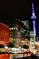
Auckland
The Auckland metropolitan area , in the North Island of New Zealand, is the largest and most populous urban area in the country with residents, percent of the country's population. Auckland also has the largest Polynesian population of any city in the world...
, New Zealand
New Zealand
New Zealand is an island country in the south-western Pacific Ocean comprising two main landmasses and numerous smaller islands. The country is situated some east of Australia across the Tasman Sea, and roughly south of the Pacific island nations of New Caledonia, Fiji, and Tonga...
's largest city, is defined by various factors, among them the shape of the Auckland isthmus
Isthmus
An isthmus is a narrow strip of land connecting two larger land areas usually with waterforms on either side.Canals are often built through isthmuses where they may be particularly advantageous to create a shortcut for marine transportation...
(with its large lengths of coastline and assorted chokepoints, and thus often long distances for land transport), the suburban character of much of the Auckland area and the large car-ownership ratio of New Zealanders.
These factors have resulted in a mostly motor vehicle
Motor vehicle
A motor vehicle or road vehicle is a self-propelled wheeled vehicle that does not operate on rails, such as trains or trolleys. The vehicle propulsion is provided by an engine or motor, usually by an internal combustion engine, or an electric motor, or some combination of the two, such as hybrid...
-based transport system, which uses several major motorways as its main arteries (due to the geography of the isthmus, there are almost no ring routes). Public transport in Auckland
Public transport in Auckland
Public transport in Auckland, the largest metropolitan area of New Zealand, consists of three modes – bus, train and ferry. Services are provided under the "MAXX" brand by private transport providers, coordinated by Auckland Transport, the council controlled organisation that replaced the Auckland...
had declined to very low levels during the second half of the 20th century, though it has seen a strong resurgence in the 2000s and major efforts are underway to increase use further, partly because congestion in the city is very substantial and authorities have agreed that further road projects alone will not be sufficient to combat it. Experts in urban planning and transport policy have also criticised how unfriendly the city is for pedestrians and cyclists, to a degree rarely seen in the First World.
Auckland has New Zealand's largest commercial port
Ports of Auckland
Ports of Auckland Limited , the successor to the Auckland Harbour Board, is the company administering Auckland's commercial freight and cruise ship harbour facilities...
(mostly used for international commerce) as well as the country's largest international airport. It also has the Southern Hemisphere's largest marina
Westhaven Marina
Westhaven Marina in Auckland, New Zealand, is the largest yacht marina in the Southern Hemisphere. The marina has nearly two thousand berths and swing moorings, and tends to be continually booked...
.
History

Auckland
The Auckland metropolitan area , in the North Island of New Zealand, is the largest and most populous urban area in the country with residents, percent of the country's population. Auckland also has the largest Polynesian population of any city in the world...
's initial (19th century) urban growth occurred in a very intense fashion, concentrated around the harbour in a very similar manner to most other mercantile cities, with lack of transportation options limiting development to locations within walking distance of each other. The overcrowding of the inner city eventually created a demand for expansion made viable when new transportation technology appeared around 1900 in the form of streetcars (trams) and railways arriving in Auckland.
Auckland’s first tram
Tram
A tram is a passenger rail vehicle which runs on tracks along public urban streets and also sometimes on separate rights of way. It may also run between cities and/or towns , and/or partially grade separated even in the cities...
(streetcar) line, from the CBD
Central business district
A central business district is the commercial and often geographic heart of a city. In North America this part of a city is commonly referred to as "downtown" or "city center"...
to Ponsonby
Ponsonby
Ponsonby is a surname which may refer to:*Arthur Ponsonby, 1st Baron Ponsonby of Shulbrede was a British politician, writer, and social activist...
via Karangahape Road
Karangahape Road
Karangahape Road is one of the main streets in the central business district of Auckland, New Zealand. The massive expansion of motorways through the nearby inner city area - and subsequent flight of residents and retail into the suburbs - turned it from one of Auckland's premier shopping streets...
was opened on November 24, 1902, and as the system grew, it facilitated the expansion of Auckland’s built-up area in two ways: in an intermittent linear pattern to the west and south along the railway line, and in a more continuous manner along the main streetcar routes. The demand for more living space from people who had been confined to the crowded downtown area, coupled with an affordable and reliable transportation network led to the creation of many of Auckland's original suburbs, along Great North Road, New North Road, Sandringham Road, Dominion Road, Mt Eden Road, Manukau Road and Remuera Road, forming a new arc of suburban development in Auckland by 1915.
Auckland first railway, from Queen Street Auckland to Onehunga opened in 1873. Expansion of the railway network facilitated growth in more distant locations, such as Otahuhu
Otahuhu
Otahuhu is a suburb of Auckland. It is located to the southeast of the city centre, on a narrow isthmus between an arm of the Manukau Harbour to the west and the Tamaki River estuary to the east...
and New Lynn, while ferries served Devonport
Devonport, New Zealand
Devonport is a harbourside suburb of Auckland, New Zealand. It is located on the North Shore, at the southern end of a peninsula that runs southeast from near Lake Pupuke in Takapuna, forming the northern side of the Waitemata Harbour...
, Takapuna
Takapuna
Takapuna is a central, coastal suburb of North Shore City, located in the northern North Island of New Zealand, at the beginning of a south-east-facing peninsula forming the northern side of the Waitemata Harbour...
and Birkenhead
Birkenhead, New Zealand
Birkenhead is a suburb of Auckland, in northern New Zealand. It is located on the north shore of the Waitemata Harbour, four kilometres northwest of the Auckland city centre....
on the North Shore. Indeed, Auckland’s urban development in the early twentieth century is intrinsically linked to its transportation networks, and because of their limited reach (compared to that of the automobile) the city developed in a fairly compact manner to maximise the efficiency of the streetcar, railway and ferry systems. However, this situation was not to last for long, as even before the Second World War the automobile was becoming an integral part of life for many New Zealanders, opening up previously unreachable land for development.
The number of automobiles in New Zealand skyrocketed from 37,500 in 1922 to 261,850 in 1938, at that stage the second highest rate of vehicles per capita in the world after the United States
United States
The United States of America is a federal constitutional republic comprising fifty states and a federal district...
. This growing popularity meant that urban development could break free from the constraints of predetermined transit networks and occur anywhere roads were built. This would become a mixed blessing, as commuters were no longer forced to locate close to their place of work or to a streetcar line - leading to a rapid decentralisation of urban growth, today often referred to as urban sprawl
Urban sprawl
Urban sprawl, also known as suburban sprawl, is a multifaceted concept, which includes the spreading outwards of a city and its suburbs to its outskirts to low-density and auto-dependent development on rural land, high segregation of uses Urban sprawl, also known as suburban sprawl, is a...
. In a complementary move to combat the threat of the suburbs upstaging the CBD in commercial importance, parking lots and later, parking buildings started to spring up in the central city, with the first municipal parking building (Britomart Place) being erected in 1958. This trend increased in the 1960s as shopping centres brought more retail competition into the suburbs.
With the changing public and political opinions on public transport, the last tram lines were removed by 1956, and roads finally became fully paramount, with the extension of arterial roads and the state highway system. Also waned has the importance of shipping, which in historical times (i.e. the first century of settlement) was often dominant over land routes. Nowadays, shipping is mostly restricted to some ferry services and freight, as well as to yachting
Yachting
Yachting refers to recreational sailing or boating, the specific act of sailing or using other water vessels for sporting purposes.-Competitive sailing:...
, which is not strictly a form of transport.
Trends
Auckland's transport, and the transport of all its constituent cities, is dominated by the motor vehicleMotor vehicle
A motor vehicle or road vehicle is a self-propelled wheeled vehicle that does not operate on rails, such as trains or trolleys. The vehicle propulsion is provided by an engine or motor, usually by an internal combustion engine, or an electric motor, or some combination of the two, such as hybrid...
. This is ascribed by many to Auckland's low density, which makes public transport more costly. Public transport in Auckland has declined heavily in use during the 20th century, a common trend in most Western cities, but as some researchers suggest, also due to a long-term history of the city having one of the most car-favouring transport policies worldwide. In recent years, growth of the city and increasing traffic congestion have caused public transport to again receive higher priority, though some question the viability of wanting to achieve Auckland's sustainability
Sustainability
Sustainability is the capacity to endure. For humans, sustainability is the long-term maintenance of well being, which has environmental, economic, and social dimensions, and encompasses the concept of union, an interdependent relationship and mutual responsible position with all living and non...
and mobility goals with this form of transport.
Rail freight transport has also declined in importance through the last decades. Most new growth (and the import and export trade via Ports of Auckland
Ports of Auckland
Ports of Auckland Limited , the successor to the Auckland Harbour Board, is the company administering Auckland's commercial freight and cruise ship harbour facilities...
) occurs on the roads. In this matter, Auckland and New Zealand follows the example of other westernised countries, where the great flexibility of the truck eclipsed the train in terms of market share.
At the same time, Auckland sees about 40 additional cars registered a day (2007), with traffic on the city's roads increasing between 1-3% a year. "Peak hour" conditions now extend over almost seven hours a day, leading both city and Transit New Zealand representatives to the conclusion that focusing solely on cars will not alleviate the congestion issues. They also agree that rather than simply providing more space for traffic to flow freely, projects like the Victoria Park Tunnel
Victoria Park Tunnel
The Victoria Park Tunnel is a motorway tunnel under construction on New Zealand State Highway 1 in Auckland, New Zealand. When finished end of 2011, it is to take the northbound traffic off the Victoria Park Viaduct, which will then be converted to all southbound traffic...
would in fact cause traffic increases.
Funding
While there is a widespread belief in New Zealand that taxes gathered in the rest of the country are extensively spent in Auckland, in terms of transport, the reality has been different for many years. Of the NZ$7 billion paid by Aucklanders between 1990 and 2005 in fuel taxes, road user charges and vehicle fees, only about $3 billion was reinvested in transport-related funding in the region.To remedy some of the transport defects existing, the Auckland Region was to be subject to a regional fuel tax of between 5c and 10c per litre from January 1, 2009, which was to be spent on transport infrastructure enhancements in the region, focusing on (but not exclusive to) public transport in Auckland
Public transport in Auckland
Public transport in Auckland, the largest metropolitan area of New Zealand, consists of three modes – bus, train and ferry. Services are provided under the "MAXX" brand by private transport providers, coordinated by Auckland Transport, the council controlled organisation that replaced the Auckland...
. The funding decisions for the money raised was to be split between the New Zealand government (which intends to focus on electrifying Auckland's rail tracks
Auckland Railway electrification
The Auckland railway electrification has been proposed for several decades, but physical works only began in the late 2000s. After investment into new infrastructure and improved services created massive patronage gains on Auckland's commuter rail network in the middle 2000s, the long-discussed...
, completing the Western Ring Route
Western Ring Route
The Western Ring Route is a motorway system being constructed in Auckland, New Zealand. It runs along three existing state highways: the Southwestern Motorway , the Northwestern Motorway and the Upper Harbour Highway . When finished it will surpass the Southern Motorway to become the longest...
and helping Rodney District Council build a toll road
Toll road
A toll road is a privately or publicly built road for which a driver pays a toll for use. Structures for which tolls are charged include toll bridges and toll tunnels. Non-toll roads are financed using other sources of revenue, most typically fuel tax or general tax funds...
to Whangaparaoa Peninsula
Whangaparaoa Peninsula
Whangaparaoa Peninsula is a peninsula and suburban area, around 25 km north of Auckland, New Zealand. Part of Rodney District, as of 2006, it had 22,788 residents, many of them in the eponymous town of Whangaparaoa on its southern side.-Geography:...
) and the Auckland Regional Council
Auckland Regional Council
The Auckland Regional Council was the regional council of the Auckland Region. Its predecessor the Auckland Regional Authority was formed in 1963 and became the ARC in 1989...
(which intended to spend money on 35 new electric trains and support facilities, maintenance and upgrade of existing diesel trains, tracks and stations, ferry terminal upgrades and an electronic ticketing system). In addition to its share of the fuel tax money, the ARC was also to invest hundreds of millions from its regional rate money into these projects.
However, the regional fuel tax was eventually canned by national government, against the wishes of the ARC, though some local authorities welcomed the additional national funding, and some editorialists argued that national-level funding for Auckland's transport woes was only just, seeing that funds for transport projects in preceding decades had, per capita, gone disproportionally to the countryside of New Zealand, with the fuel tax concept leaving Auckland to pay extra for its transport.
While government has promised to make up funding for projects like electrification of the rail network (partly from the national fuel tax, which is to be retained), a significant funding gap of around NZ$202 million remained for various projects as of mid-2009. Critics have also decried that the move significantly disempowers Auckland's authorities by removing their ability to fund their own projects, thus putting them at the mercy of decisions made at a national level – visible by decisions such as the ARC now having been forced in March 2010 to hand ownership over their train stations to the national rail provider ONTRACK
OnTrack
OnTrack was a regional rail line that operated in Syracuse, New York from 1994 to 2007. During its operation, Syracuse was the smallest city in the United States to have regional train service. The line ran from Colvin Street on the city's south side via Syracuse University and Armory Square to the...
- because the sudden funding hole would have otherwise meant an untenable rates rise of 15% over an already planned increase of 3.9%. Mike Lee, the ARC chairman, called the development a 'technical confiscation'.
In November 2009, government confirmed that it would fund the second $500 million half of the electrification project from Crown funds, and had approved it in the budget. This was applauded by regional politicians including ARC chairman Mike Lee, who however also noted that the government change of mind had cost over a year of delay.
Overview

State highway
State highway, state road or state route can refer to one of three related concepts, two of them related to a state or provincial government in a country that is divided into states or provinces :#A...
network, planned decades ago during the height of the post-World War II road building era, remains incomplete as of 2008. It is unlikely that this original plan will ever be built in its entirety because of strong public resistance to more roads in built-up areas of the Isthmus. A number of crucial gaps do exist in the current network, mainly the fact that there is no motorway detour around the Central Motorway Junction south of the CBD
Central business district
A central business district is the commercial and often geographic heart of a city. In North America this part of a city is commonly referred to as "downtown" or "city center"...
, thus forcing all motorway traffic in the Isthmus to pass through it. This is being addressed by the State Highway 20 (SH20) extensions through southern and western Auckland (see below). A similar chokepoint is the Auckland Harbour Bridge towards North Shore City (also see below).
Auckland motorways often also have an arterial road
Arterial road
An arterial road, or arterial thoroughfare, is a high-capacity urban road. The primary function of an arterial road is to deliver traffic from collector roads to freeways, and between urban centres at the highest level of service possible. As such, many arteries are limited-access roads, or feature...
function (i.e. they are being used for short-distance trips within the conurbation instead of solely for long-distance traffic), which further aggravates congestion, especially between the centre of Auckland and Waitakere City, North Shore City and Manukau City. Ramp signals have recently (late 2000s) been installed on many on-ramps, to regulate the flow onto the motorway. While this causes delays and vehicle queues when getting onto the motorway, it produces smoother through flows on the motorway itself. Around 30 onramps are eventually to be controlled in this way, at a cost of NZ$50 million.
Recent improvements to the Northern Motorway (which have also included a bus expressway) have greatly reduced travel times from the North Shore to Orewa
Orewa
Orewa, a town in New Zealand's North Island lies on the Hibiscus Coast, just north of the base of the Whangaparaoa Peninsula and 40 kilometres north of central Auckland. Orewa's population was 7,326 in the 2006 Census, an increase of 1,692 from 2001. It is a popular holiday destination...
, while at the same time extending Auckland's urban sprawl
Urban sprawl
Urban sprawl, also known as suburban sprawl, is a multifaceted concept, which includes the spreading outwards of a city and its suburbs to its outskirts to low-density and auto-dependent development on rural land, high segregation of uses Urban sprawl, also known as suburban sprawl, is a...
into southern Rodney District
Rodney District
The Rodney District of New Zealand was a local government area in the northernmost part in New Zealand's Auckland Region, created in 1989 from the amalgamation of Helensville Borough and Rodney County. The seat of the district council is at Orewa, and the district includes Kawau Island to the...
. It is projected that Orewa will eventually be swallowed up by Auckland's northward urban expansion.
Western Ring Route
The Southwestern Motorway (SH20), coming from the south-east, currently (2010) ends in the suburb of SandringhamSandringham, New Zealand
Sandringham is a suburb of Auckland City, New Zealand. Sandringham is a bustling, multi-ethnic suburb, and has a population of 10,800.Sandringham was named after the country house of Edward, Prince of Wales. This house, which is located in Norfolk, England, is the private property of the British...
. This highway, once it is linked up to the Northwestern Motorway westwards to Waitakere City, will provide a way of detouring the Central Motorway Junction, thus taking some pressure from SH1 and the Auckland Harbour Bridge.
The Mt Roskill–Waterview
Waterview, New Zealand
Waterview is a suburb of Auckland City, located along the western edge of central part of Auckland's isthmus. The geographical boundaries of Waterview are Oakley Creek in the east, Heron Park in the south, the Waitemata Harbour in the West, and the SH16 motorway and the Oakley Creek inlet in the...
section of the Western Ring Route is called the Waterview Connection
SH20 Waterview Connection
The Waterview Connection is a planned motorway section which will form part of the Western Ring Route through Auckland, New Zealand. It is to connect the stub of State Highway 20 in the south from Mt Roskill to join up with another motorway, State Highway 16 in the west at Point Chevalier, and is a...
, and is to cost about $1.4 billion. Due to this high cost, the ecological significance of some of the affected sections, and the debate about the cost-efficiency of tunneling versus the negative effects of a surface route on the relatively heavily settled area, this project has long been the most controversial link of the Western Ring Route. In 2009, the new National government declared it a "Road of National Significance" and fast-tracked the project, which is now (as of early 2010) close to the supposedly final consenting process, and could be completed by 2015-16.
Eastern Transport Corridor
During the 2001-2004 term the mayors of Auckland City and Manukau, John BanksJohn Banks (New Zealand)
John Archibald Banks, CNZM QSO is a New Zealand politician. He served as Mayor of Auckland City for two terms, from 2001 to 2004, and from 2007 to 2010...
and Sir Barry Curtis
Barry Curtis
Sir Barry Curtis was the Mayor of Manukau from 1983 until 2007. When he announced his intention to retire in 2007, he was New Zealand's longest serving mayor at that time.-Career:...
respectively, strongly advocated a proposal for an Eastern Transport Corridor
Eastern Transport Corridor
The Eastern Transport Corridor in Auckland, New Zealand, is a transport reserve along a strip of land and water some of which is occupied by housing, commerce, industry and local roads...
, including significant roading elements. Vociferous campaigners both supported and opposed the NZ$4 billion proposal throughout the term. John Banks subsequently lost the 2004 local body election, chiefly due to public opposition to the proposed motorway, including wards that were traditionally supportive of Banks' centre-right governance. The next Auckland City Council had a centre-left grouping as its largest bloc, aided by the anti-motorway Action Hobson
Action Hobson
Action Hobson were a centrist council ticket in the Hobson Ward of Auckland City, New Zealand. They were formed to combat the proposed Eastern Transport Corridor by then Mayor of Auckland City, John Banks , and his supporting Citizens and Ratepayers Now bloc.-History:In the October 2004 election,...
ticket. The corresponding Deputy Mayor Bruce Hucker announced in early November 2004 a major change in direction for Auckland City. No substantial action (beyond some policy work) was undertaken in the corridor area.
John Banks subsequently won the following election in 2007 and once again became Mayor, although the original proposals for the Eastern Transport Corridor have been revised substantially because of a new focus on 'affordable' progress. Fewer roads are to be constructed, with a stronger emphasis on public transport and connections with Manukau City instead of with the Auckland CBD.
AMETI (Auckland-Manukau)
Partly based on the strong opposition to the Eastern Transport CorridorEastern Transport Corridor
The Eastern Transport Corridor in Auckland, New Zealand, is a transport reserve along a strip of land and water some of which is occupied by housing, commerce, industry and local roads...
, the new AMETI (Auckland-Manukau Eastern Transport Initiative) project intends to primarily improve the connections of eastern Auckland towards the south-east (Manukau City), via less problematic routes. The new roads and public transport links are to serve intensified residential and mixed developments like the Mount Wellington Quarry area. Construction is to begin in 2008 and to be finished around 2015, costing around NZ$1 billion.
Central Motorway Junction
Since 2001, several motorway construction projects began in and around the Central Motorway Junction (CMJ, also known as "Spaghetti Junction"), and in December 2006, the new sections of the CMJ were opened to traffic. The difficult works involved fitting various new lanes, as well as on- and off-ramps into a multi-story (and multi-level) interchange, which also, within a length of just a few kilometres, offers multiple connections into the city.Previously, northbound traffic from (as well as to) Auckland Harbour had to follow a waterfront route from the east of the CBD to the west and get onto SH1 near Victoria Park
Victoria Park, Auckland
Victoria Park is a park and sports ground in Auckland City, New Zealand. It lies on reclaimed bay land in Freemans Bay, a suburb directly west of the Auckland CBD. This origin of the land makes it very flat and level...
. The new CMJ layout allows northbound traffic to travel via Grafton Gully
Grafton Gully
Grafton Gully is a deep and very wide gully cutting northwards through the volcanic hills of the Auckland Volcanic Field in Auckland, New Zealand. It divides the CBD of the city from the suburbs of Grafton and Parnell in the east.Grafton Gully is crossed by Grafton Bridge near its south end...
onto SH1, to then continue over the harbour bridge northwards, reducing truck traffic in downtown Auckland. The second major change provides direct motorway-motorway connections from the Northern (SH1) to the Northwestern Motorway (SH16), or vice versa, where previously, they had to travel through a congested stretch of the southern Auckland CBD.
The four year, NZ$207 million project has been described as a 'gruelling struggle of "overs and unders" in which engineers have managed to snake and squeeze the new links through a devilishly tight corridor', while also being required to stay within the strict geometric minimum standards for a high-quality motorway.
Major bridges
An iconic structure of Auckland, the harbour bridge is also a bottleneck for traffic. With the only other north-south motorway connection involving a wide detour through WaitakereWaitakere
Waitakere City was the name of a city which existed from 1989 until 2010 in the Auckland region. It was New Zealand's fifth largest city, with an annual growth of about 2%...
, this bridge has to accommodate large amounts of rush hour traffic, mainly from the North Shore into the city in the morning, and vice-versa in the afternoon.
The bridge was extended in 1969 by constructing cantilevered 'clip-on' lanes at both outer sides of the original construction, giving it 8 lanes in total (from 4 lanes before). As this eventually was still not enough to manage the growing traffic loads, a traffic management solution involving a movable barrier was installed, giving it 5 lanes per dominant direction depending on the time of day. A second crossing, likely as a tunnel, is proposed, but would still be a decade or more away even if approved.
This bridge carries State Highway 20 over the Mangere Inlet of the Manukau Harbour
Manukau Harbour
Manukau Harbour is the second largest natural harbour in New Zealand by area. It is located to the southwest of the Auckland isthmus, and is an arm of the Tasman Sea.-Geography:...
. While at the moment, SH20 ends in southern Auckland (coming from the southeast), the completion of the Western Ring Route will further increase the importance of this link.
This 700 m long motorway viaduct to the southeast of the CBD carries the Southern Motorway
Auckland Southern Motorway
The Auckland Southern Motorway is the major route south out of the Auckland Region of New Zealand. It is part of State Highway 1....
over Newmarket
Newmarket, New Zealand
Newmarket is an Auckland suburb to the south-east of the central business district. With its high building density, especially of retail shops, it is considered New Zealand's premier retailing area, and a rival of local competitor Auckland CBD...
. This section of the motorway carries more traffic than the Auckland Harbour Bridge which is often wrongly considered the most-used part of the Auckland motorway system. Built to relatively low earthquake standards, the bridge is to be replaced by a new structure within the next few years, possibly before 2011.
This bridge in the northwest of Auckland, between Waitakere City and North Shore City, is an important part of the connection between those cities, and also offers an alternative route to the Auckland Harbour Bridge, which is going to become even more important with the completion of the Western Ring Route.
Public transport
Britomart Transport Centre
Britomart Transport Centre is the CBD public transport hub of Auckland, New Zealand, and the northern terminus of the North Island Main Trunk line. It combines a bus interchange with a railway station in a former Edwardian post office, extended with expansive post-modernist architectural elements...
near the Auckland waterfront
Auckland waterfront
The Auckland waterfront is a city-side stretch of the southern Waitemata Harbour coastline in Auckland City, New Zealand...
, opened July 2003, where ferry, bus and train services meet.
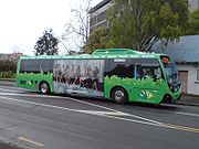
Bus services
Bus services, the bulk of public transport in the city, are mostly provided by NZ Bus, under the Auckland Transport - MAXXMAXX Blue (livery)
thumb|Passengers board a MAXX branded Northern Express operated by [[Ritchies Coachlines]] on the [[Northern Busway, Auckland|Northern Busway]]....
. Bus lines are mainly radial lines connecting Auckland CBD
Central business district
A central business district is the commercial and often geographic heart of a city. In North America this part of a city is commonly referred to as "downtown" or "city center"...
with the suburbs. Various large scale bus priority
Bus priority
Bus priority or transit signal priority is a name for various techniques to speed up bus public transport services at intersections with traffic signals amongst other methods. Trams and light rail vehicles can also be given priority...
measures have been implemented in recent years, such as the Central Connector
Central Connector, Auckland
The Central Connector , is a bus rapid transit link between Britomart Transport Centre in the Auckland CBD, New Zealand, and the commercial suburb of Newmarket. It is to improve journey times by about 14 minutes for around to 2,600 buses per week, about 65,000 passengers daily...
(opened in November 2009) and the Northern Busway
Northern Busway, Auckland
thumb|Passengers boarding a [[MAXX Regional Transport]] Northern Express service operated by [[Ritchies Coachlines]].The Northern Busway is a physically separated busway with dedicated park & ride facilities along State Highway 1 in the north of Auckland, New Zealand, linking the North Shore with...
(opened in early 2008).
Frequent long-distance services, principally operated by Intercity
Intercity (New Zealand)
InterCity Group Ltd is a passenger transport and tourism company and operates New Zealand's largest coach network and ferries and cruises in the Bay of Islands...
and its subsidiary Newmans, link Auckland with all the main centres throughout the North Island
North Island
The North Island is one of the two main islands of New Zealand, separated from the much less populous South Island by Cook Strait. The island is in area, making it the world's 14th-largest island...
.
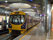
Rail services
Auckland has only one long distance rail passenger service: The Overlander (operated by Tranz ScenicTranz Scenic
Tranz Scenic is the long-distance passenger train brand of KiwiRail, formed from the New Zealand Railways Corporation InterCity Rail services. Tranz Scenic was renamed along with the other operating divisions of Tranz Rail in 1995...
, a division of KiwiRail
KiwiRail
KiwiRail Holdings Limited is the rail operations subsidiary of the New Zealand Railways Corporation, which trades as KiwiRail. Headquartered in Wellington, New Zealand, KiwiRail is the largest rail transport operator in New Zealand. Since July 2010 John Spencer has been the Chairman...
) between Auckland and Wellington, operating daily during the summer months and on Friday, Saturday and Sunday during the winter months.
There are four main railway lines in the Auckland Region itself - the Western, Southern, Eastern and Onehunga lines. Auckland's urban rail services are operated under the MAXX
MAXX Blue (livery)
thumb|Passengers board a MAXX branded Northern Express operated by [[Ritchies Coachlines]] on the [[Northern Busway, Auckland|Northern Busway]]....
brand by Veolia
Veolia (New Zealand)
Veolia Transport Auckland, formerly Connex Auckland Ltd, is a division of Australasia's largest passenger train company, French-owned Veolia. It runs Auckland's urban passenger trains under contract from Auckland Transport under their MAXX brand, on infrastructure owned and managed by KiwiRail...
. Since the opening of Britomart Transport Centre
Britomart Transport Centre
Britomart Transport Centre is the CBD public transport hub of Auckland, New Zealand, and the northern terminus of the North Island Main Trunk line. It combines a bus interchange with a railway station in a former Edwardian post office, extended with expansive post-modernist architectural elements...
, significant improvements were made to the local-area rail services. In October 2005, Sunday services were reintroduced for the first time in over 30 years, with more peak hour trains and later trains on Friday and Saturday nights in particular.
Recent (late 2000s and ongoing) investment in Auckland's rail services has resulted in strongly increased patronage, though from a very low level. Investment has focused on upgrading and refurbishing the current rolling stock and railway stations. Some double-tracking to allow higher frequencies has been undertaken or is in planning, and has resulted in a 25% increase in frequency, and a rise in punctuality (defined as trains being late 5 minutes or less) from 60.9% in 2005 to 83.1% in 2006. Large new infrastructure investments have recently (mid 2007) been signed off by all parties, and NZ$1 billion will be invested within the next decade in electrifying the commuter network
Auckland Railway electrification
The Auckland railway electrification has been proposed for several decades, but physical works only began in the late 2000s. After investment into new infrastructure and improved services created massive patronage gains on Auckland's commuter rail network in the middle 2000s, the long-discussed...
and buying new rolling stock
Rolling stock
Rolling stock comprises all the vehicles that move on a railway. It usually includes both powered and unpowered vehicles, for example locomotives, railroad cars, coaches and wagons...
to use on the electrified lines. This is in addition to NZ$600 million already being spent on double-tracking heavily used sections of the network. Major further works, such as a rail connection to Auckland Airport, a rail tunnel to North Shore City, or an underground loop tunnel through the Auckland CBD
Auckland CBD
The Auckland CBD is the geographical and economic heart of the Auckland metropolitan area. Bounded by several major motorways and by the harbour coastline in the north, it is surrounded further out by mostly suburban areas...
are proposed but have not yet moved beyond the concept stage.
Ferry services

Significant services also connect the city with Waiheke Island
Waiheke Island
Waiheke Island is an island in the Hauraki Gulf of New Zealand, located about from Auckland.The island is the second-largest in the Hauraki Gulf after Great Barrier Island. It is the most populated, with nearly 8,000 permanent residents plus another estimated 3,400 who have second or holiday homes...
, Gulf Harbour
Gulf Harbour
Gulf Harbour is a development some 4 km from the end of the Whangaparaoa Peninsula, towards the northern end of Auckland, New Zealand. It has one of the country's largest marinas, one of the country's top golf courses, and is regarded as a retreat for Auckland's well-off...
and Half Moon Bay
Half Moon Bay, Auckland
Half Moon Bay is a coastal suburb located immediately south of Bucklands Beach in Manukau City, Auckland, New Zealand.It is well known for the Half Moon Bay Marina, home to over 500 boats...
. Ferries to Great Barrier Island
Great Barrier Island
Great Barrier Island is a large island of New Zealand, situated to the north-east of central Auckland in the outer Hauraki Gulf. With an area of it is the fourth-largest island of New Zealand's main chain of islands, with its highest point, Mount Hobson, rising...
are less regular, with 4h-long passages once every 1–2 days, depending on the time of the year and the weather. Rangitoto
Rangitoto Island
Rangitoto Island is a volcanic island in the Hauraki Gulf near Auckland, New Zealand. The 5.5 km wide island is an iconic and widely visible landmark of Auckland with its distinctive symmetrical shield volcano cone rising 260 metres high over the Hauraki Gulf...
, Motuihe Island
Motuihe Island
Motuihe Island lies between Motutapu and Waiheke islands in the Hauraki Gulf of New Zealand, near Auckland. The island measures about , of which around are remnants of coastal forest. The island is a recreation reserve controlled by the Department of Conservation and administered by the Motuihe...
and Tiritiri Matangi Island
Tiritiri Matangi Island
Tiritiri Matangi Island lies in the Hauraki Gulf of New Zealand, east of the Whangaparaoa Peninsula in the North Island and north east of Auckland. The island is an open nature reserve managed under the supervision of the Department of Conservation and is noted for its bird life, including kiwi...
and the Coromandel
Coromandel Peninsula
The Coromandel Peninsula lies in the North Island of New Zealand. It is part of the Waikato Region and Thames-Coromandel District and extends 85 kilometres north from the western end of the Bay of Plenty, forming a natural barrier to protect the Hauraki Gulf and the Firth of Thames in the west...
have services usually focused on weekend and tourist trips.
Currently, there are no ferry services on the western shores of Auckland, and none are planned, as Auckland's waterfront
Auckland waterfront
The Auckland waterfront is a city-side stretch of the southern Waitemata Harbour coastline in Auckland City, New Zealand...
waterfront orientation is much stronger towards the east (Waitemata Harbour
Waitemata Harbour
The quite famous Waitemata Harbour is the main access by sea to Auckland, New Zealand. For this reason it is often referred to as Auckland Harbour, despite the fact that it is only one of two harbours surrounding the city, and is crossed by the Auckland Harbour Bridge. The Waitemata forms the north...
) than to the west (Manukau Harbour
Manukau Harbour
Manukau Harbour is the second largest natural harbour in New Zealand by area. It is located to the southwest of the Auckland isthmus, and is an arm of the Tasman Sea.-Geography:...
).
Freight turnover
Auckland also has New Zealand's largest commercial port, its turnover exceeding even that of large rivals like TaurangaTauranga
Tauranga is the most populous city in the Bay of Plenty region, in the North Island of New Zealand.It was settled by Europeans in the early 19th century and was constituted as a city in 1963...
substantially. Ports of Auckland
Ports of Auckland
Ports of Auckland Limited , the successor to the Auckland Harbour Board, is the company administering Auckland's commercial freight and cruise ship harbour facilities...
, the company managing all Auckland ports, handles the movement of 60% of New Zealand's imports and 40% of New Zealand's exports (both by value). 70% of this trade enters or leaves the country in containers
Intermodal container
An intermodal container is a standardized reusable steel box used for the safe, efficient and secure storage and movement of materials and products within a global containerized intermodal freight transport system...
- though ships unloading large amounts of cars are also a typical sight at the wharves of Auckland. The ports move 4 million tonnes of 'breakbulk' cargo per year, as well as over 670,000 TEUs (Twenty-foot equivalent container units
Twenty-foot equivalent unit
The twenty-foot equivalent unit is an inexact unit of cargo capacity often used to describe the capacity of container ships and container terminals...
) (2006).
According to an economic impact assessment, a third of the regional economy and 173,000 jobs in Auckland Region
Auckland Region
The Auckland Region was one of the sixteen regions of New Zealand, named for the city of Auckland, the country's largest urban area. With one third of the nation's residents, it was by far the biggest population and economy of any region of New Zealand, but the second-smallest land area.On 1...
are dependent on the port.
Cruise ships
In the 2005/2006 season, POAL also catered for 48 cruise ship visits (at the Overseas Passenger Terminal, Princes WharfPrinces Wharf
Princes Wharf is a former commercial wharf on the Auckland waterfront, in Auckland City, New Zealand, which has been redeveloped into a multi-story high-class mixed-use development and cruise ship terminal....
), with more than 100,000 passengers passing through the port, mostly disembarking for short stopover trips into Auckland or the surrounding region.
Air transport
With Auckland being the largest city of New Zealand, a great number of international and national flight connections exist. Main routes are to AustraliaAustralia
Australia , officially the Commonwealth of Australia, is a country in the Southern Hemisphere comprising the mainland of the Australian continent, the island of Tasmania, and numerous smaller islands in the Indian and Pacific Oceans. It is the world's sixth-largest country by total area...
, Singapore
Singapore
Singapore , officially the Republic of Singapore, is a Southeast Asian city-state off the southern tip of the Malay Peninsula, north of the equator. An island country made up of 63 islands, it is separated from Malaysia by the Straits of Johor to its north and from Indonesia's Riau Islands by the...
, Hong Kong
Hong Kong
Hong Kong is one of two Special Administrative Regions of the People's Republic of China , the other being Macau. A city-state situated on China's south coast and enclosed by the Pearl River Delta and South China Sea, it is renowned for its expansive skyline and deep natural harbour...
, Japan
Japan
Japan is an island nation in East Asia. Located in the Pacific Ocean, it lies to the east of the Sea of Japan, China, North Korea, South Korea and Russia, stretching from the Sea of Okhotsk in the north to the East China Sea and Taiwan in the south...
, and to the US West Coast
West Coast of the United States
West Coast or Pacific Coast are terms for the westernmost coastal states of the United States. The term most often refers to the states of California, Oregon, and Washington. Although not part of the contiguous United States, Alaska and Hawaii do border the Pacific Ocean but can't be included in...
. Within New Zealand, the main connections are to the capital in Wellington
Wellington
Wellington is the capital city and third most populous urban area of New Zealand, although it is likely to have surpassed Christchurch due to the exodus following the Canterbury Earthquake. It is at the southwestern tip of the North Island, between Cook Strait and the Rimutaka Range...
and to the main city of the South Island, Christchurch
Christchurch
Christchurch is the largest city in the South Island of New Zealand, and the country's second-largest urban area after Auckland. It lies one third of the way down the South Island's east coast, just north of Banks Peninsula which itself, since 2006, lies within the formal limits of...
. However, smaller planes fly to almost all other cities and to many small airports all over New Zealand.
Historically, Auckland had first been served by flying boat services from Mechanics Bay
Mechanics Bay
Mechanics Bay is the name of a former bay on the Waitemata Harbour in Auckland City, New Zealand. It is also the name used to describe the area of the former bay that is now mainly occupied by commercial and port facilities...
and Hobsonville
Hobsonville
Hobsonville is a former Royal New Zealand Air Force airfield which are currently being redeveloped as a new suburb of Auckland, in the area of the former Waitakere City, New Zealand...
. As aircraft such as the Short Solent
Short Solent
- External links :* * *...
and Short Sunderland
Short Sunderland
The Short S.25 Sunderland was a British flying boat patrol bomber developed for the Royal Air Force by Short Brothers. It took its service name from the town and port of Sunderland in northeast England....
were replaced by land-based planes, the first airport was opened at Mangere
Mangere
Māngere is one of the larger suburbs in South Auckland, in northern New Zealand.The suburb is located on flat land at the northeastern shore of the Manukau Harbour, to the northwest of the centre of Manukau city and 15 kilometres south of Auckland city centre...
, supplanting earlier airfields at Ardmore and Whenuapai
Whenuapai
Whenuapai is a suburb and airport located in the western Waitakere area of Auckland City, in the North Island of New Zealand. It is located on the northwestern shore of the Waitemata Harbour, 15 kilometres to the northwest of Auckland's city centre. It is one of the landing points for the Southern...
.
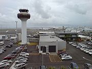
Airports
Auckland Airport, New Zealand's largest airport, lies beside Manukau HarbourManukau Harbour
Manukau Harbour is the second largest natural harbour in New Zealand by area. It is located to the southwest of the Auckland isthmus, and is an arm of the Tasman Sea.-Geography:...
, in the southern suburb of Mangere
Mangere
Māngere is one of the larger suburbs in South Auckland, in northern New Zealand.The suburb is located on flat land at the northeastern shore of the Manukau Harbour, to the northwest of the centre of Manukau city and 15 kilometres south of Auckland city centre...
, which is part of Manukau
Manukau
Manukau City was a large territorial authority in Auckland, New Zealand. The city was sometimes referred to as South Auckland, but this term did not possess official recognition and did not encompass areas like East Auckland, which was previously within the official boundaries of Manukau City...
. It is a major base for Air New Zealand
Air New Zealand
Air New Zealand Limited is the national airline and flag carrier of New Zealand. Based in Auckland, New Zealand, the airline operates scheduled passenger flights to 26 domestic destinations and 24 international destinations in 15 countries across Asia, Europe, North America and Oceania, and is...
. A new runway is planned north of the main airport area, with a shorter length well suitable for the booming intra-New Zealand flight market.
Ongoing discussions concern the development of a second airport at Whenuapai
Whenuapai
Whenuapai is a suburb and airport located in the western Waitakere area of Auckland City, in the North Island of New Zealand. It is located on the northwestern shore of the Waitemata Harbour, 15 kilometres to the northwest of Auckland's city centre. It is one of the landing points for the Southern...
, a RNZAF airbase in Waitakere
Waitakere
Waitakere City was the name of a city which existed from 1989 until 2010 in the Auckland region. It was New Zealand's fifth largest city, with an annual growth of about 2%...
, to the northwest of the Auckland conurbation. As the air force is signalled to move to Ohakea base near Palmerston North
Palmerston North
Palmerston North is the main city of the Manawatu-Wanganui region of the North Island of New Zealand. It is an inland city with a population of and is the country's seventh largest city and eighth largest urban area. Palmerston North is located in the eastern Manawatu Plains near the north bank...
, the feasibility of a secondary airport north of the city is being explored.
Most private flights and light aircraft operate from the three smaller General Aviation (GA) airfields at the edges of the Auckland conurbation; Ardmore Airport south of the city which is NZ's busiest airfield in terms of movements, North Shore Aerodrome
North Shore Aerodrome
North Shore Aerodrome sometimes also called Dairy Flat airfield, is a small, uncontrolled aerodrome located south southwest of Silverdale, near Auckland in New Zealand's North Island.- Operational Information :*Lighting...
to the north and Parakai Airfield
Parakai Aerodrome
West Auckland Airport Parakai The facility previously known as Parakai Airfield was renamed as West Auckland Airport in 2011.-External links:*...
to the north west.
Mechanics Bay
Mechanics Bay
Mechanics Bay is the name of a former bay on the Waitemata Harbour in Auckland City, New Zealand. It is also the name used to describe the area of the former bay that is now mainly occupied by commercial and port facilities...
near the city centre, was the first international airport, and was used for many years as a base for flying boats
Seaplane
A seaplane is a fixed-wing aircraft capable of taking off and landing on water. Seaplanes that can also take off and land on airfields are a subclass called amphibian aircraft...
of TEAL
TEAL
Tasman Empire Airways Limited was the forerunner of Air New Zealand. It was first registered in Wellington as a limited liability company on 26 April 1940....
and amphibians
Amphibious aircraft
An amphibious aircraft or amphibian is an aircraft that can take off and land on either land or water. Fixed-wing amphibious aircraft are seaplanes that are equipped with retractable wheels, at the expense of extra weight and complexity, plus diminished range and fuel economy compared to planes...
of Tourist Air Travel and Sea Bee Air. The area now holds a heliport
Heliport
A heliport is a small airport suitable only for use by helicopters. Heliports typically contain one or more helipads and may have limited facilities such as fuel, lighting, a windsock, or even hangars...
and the Auckland Marine Rescue Centre
Auckland Marine Rescue Centre
The Auckland Marine Rescue Centre is the control centre for the Coastguard Northern Region and Surf Lifesaving Northern Region, New Zealand . It also houses other marine services such as the Harbourmaster and the Maritime Police...
.
A Royal New Zealand Air Force facility at Hobsonville
Hobsonville
Hobsonville is a former Royal New Zealand Air Force airfield which are currently being redeveloped as a new suburb of Auckland, in the area of the former Waitakere City, New Zealand...
has been vacated and is currently under redevelopment primarily as a residential area, although some light commercial and industrial uses (for example super-yacht building) are present.
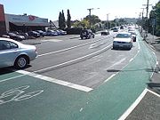
Walking and cycling
Wellington
Wellington is the capital city and third most populous urban area of New Zealand, although it is likely to have surpassed Christchurch due to the exodus following the Canterbury Earthquake. It is at the southwestern tip of the North Island, between Cook Strait and the Rimutaka Range...
and Christchurch
Christchurch
Christchurch is the largest city in the South Island of New Zealand, and the country's second-largest urban area after Auckland. It lies one third of the way down the South Island's east coast, just north of Banks Peninsula which itself, since 2006, lies within the formal limits of...
. This, and to some degree the hillier nature of Auckland, have caused cycling to so far remain a marginal pursuit - only 1% of all morning peak trips are being made by bicycle. In Wellington, with an even hillier topography, the cycling numbers were approximately twice as high as of 2008. However, in the early 2010s, indications of a reversal appeared, with a regionwide gain in cycling numbers in 2010 by 27% over the year before, and an increase of 11% in the number of people who feel cycling is a safe way of travel in the region.
Low numbers are reported for walking, with work commute trips in the Auckland Region having declined from 3.7% to 3.5% from 1996 to 2001, substantially below national levels of 5.4% in 2001. To compare with other urban areas, in Wellington more than twice (8.1%) of all trips to work were done by walking in 2001. Similar to the situation for cycling, the walking environment in Auckland is considered badly degraded due to the car-centric design of most areas.
Some efforts are being made to change this environment, with, for example, a number of shared space
Shared space
Shared space is an urban design concept aimed at integrated use of public spaces. It encourages traffic engineers, urban planners and experts from other fields to consult with users of public space when planning and designing streets and squares in both built and non-built environments...
projects planned by Auckland City Council
Auckland City Council
Auckland City Council was the local government authority representing Auckland City, New Zealand, and was amalgamated into the Auckland Council on 1 November 2010. It was an elected body representing the 404,658 residents of the city...
in several of the streets in the Auckland CBD
Auckland CBD
The Auckland CBD is the geographical and economic heart of the Auckland metropolitan area. Bounded by several major motorways and by the harbour coastline in the north, it is surrounded further out by mostly suburban areas...
, to improve the ability of pedestrians, cyclists and (slow-speed) motor vehicles to share the same transport spaces.
See also
- Auckland Airport
- Ports of AucklandPorts of AucklandPorts of Auckland Limited , the successor to the Auckland Harbour Board, is the company administering Auckland's commercial freight and cruise ship harbour facilities...
- Public transport in AucklandPublic transport in AucklandPublic transport in Auckland, the largest metropolitan area of New Zealand, consists of three modes – bus, train and ferry. Services are provided under the "MAXX" brand by private transport providers, coordinated by Auckland Transport, the council controlled organisation that replaced the Auckland...
- Transport in New ZealandTransport in New ZealandTransport in New Zealand, with its mountainous topography and a relatively small population mostly located near its long coastline, has always faced many challenges. Before Europeans arrived, Māori either walked or used watercraft on rivers or along the coasts...
External links
- Fullers The Fullers FerriesFullers FerriesFullers Group is a ferry and tourism company in Auckland, New Zealand. It operates in the Hauraki Gulf and in 2007, transported 4.2 million passengers.- Services :Fullers run ferries from the Auckland Ferry Terminal in Quay Street, Downtown Auckland...
company is the main provider for commuter services. - SeaLink Formerly Subritzky, ferry service to Waiheke and Great BarrierGreat Barrier IslandGreat Barrier Island is a large island of New Zealand, situated to the north-east of central Auckland in the outer Hauraki Gulf. With an area of it is the fourth-largest island of New Zealand's main chain of islands, with its highest point, Mount Hobson, rising...
. - 360 Discovery Cruises Harbour Cruises and trips to Tiritiri Matangi Island, Motuihe and Coromandel
- Auckland Motorways (a private website covering the Auckland motorway system)