

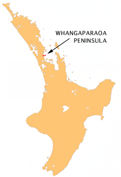
Whangaparaoa Peninsula
Encyclopedia
Auckland
The Auckland metropolitan area , in the North Island of New Zealand, is the largest and most populous urban area in the country with residents, percent of the country's population. Auckland also has the largest Polynesian population of any city in the world...
, New Zealand
New Zealand
New Zealand is an island country in the south-western Pacific Ocean comprising two main landmasses and numerous smaller islands. The country is situated some east of Australia across the Tasman Sea, and roughly south of the Pacific island nations of New Caledonia, Fiji, and Tonga...
. Part of Rodney District
Rodney District
The Rodney District of New Zealand was a local government area in the northernmost part in New Zealand's Auckland Region, created in 1989 from the amalgamation of Helensville Borough and Rodney County. The seat of the district council is at Orewa, and the district includes Kawau Island to the...
, as of 2006, it had 22,788 residents, many of them in the eponymous town of Whangaparaoa on its southern side.
Geography
Whangaparaoa Peninsula is located in the northern North IslandNorth Island
The North Island is one of the two main islands of New Zealand, separated from the much less populous South Island by Cook Strait. The island is in area, making it the world's 14th-largest island...
of New Zealand
New Zealand
New Zealand is an island country in the south-western Pacific Ocean comprising two main landmasses and numerous smaller islands. The country is situated some east of Australia across the Tasman Sea, and roughly south of the Pacific island nations of New Caledonia, Fiji, and Tonga...
, close to the base of the North Auckland Peninsula
North Auckland Peninsula
The North Auckland Peninsula, frequently referred to simply as the Northland Peninsula, is located in the far north of the North Island of New Zealand. The peninsula is easily confused with, though not the same as Northland Region, which occupies the top 80% of the peninsula...
. Whangaparaoa is Māori
Maori language
Māori or te reo Māori , commonly te reo , is the language of the indigenous population of New Zealand, the Māori. It has the status of an official language in New Zealand...
for "Bay of Whales", and pods of orca
Orca
The killer whale , commonly referred to as the orca, and less commonly as the blackfish, is a toothed whale belonging to the oceanic dolphin family. Killer whales are found in all oceans, from the frigid Arctic and Antarctic regions to tropical seas...
and dolphin
Dolphin
Dolphins are marine mammals that are closely related to whales and porpoises. There are almost forty species of dolphin in 17 genera. They vary in size from and , up to and . They are found worldwide, mostly in the shallower seas of the continental shelves, and are carnivores, mostly eating...
are regularly spotted in the waters off the peninsula. While it lies within the semi-rural Rodney District
Rodney District
The Rodney District of New Zealand was a local government area in the northernmost part in New Zealand's Auckland Region, created in 1989 from the amalgamation of Helensville Borough and Rodney County. The seat of the district council is at Orewa, and the district includes Kawau Island to the...
, the peninsula is increasingly urbanised and forms part of the Northern Auckland Zone of the Auckland
Auckland
The Auckland metropolitan area , in the North Island of New Zealand, is the largest and most populous urban area in the country with residents, percent of the country's population. Auckland also has the largest Polynesian population of any city in the world...
urban area, as defined by Statistics New Zealand
Statistics New Zealand
Statistics New Zealand is the national statistical office of New Zealand.-Organisation:New Zealand's Minister of Statistics is Maurice Williamson who serves as a member of the New Zealand House of Representatives and holds several other posts within government...
. Proposals mooted in 2006 would have seen it absorbed into North Shore City. Since 2010, it is part of Auckland.
Until relatively recently a sparsely inhabited rural area, it is now seen as something of a retreat for the more well-to-do members of Auckland society, the city lying 25 kilometres to the south. This is particularly true of the resort of Gulf Harbour
Gulf Harbour
Gulf Harbour is a development some 4 km from the end of the Whangaparaoa Peninsula, towards the northern end of Auckland, New Zealand. It has one of the country's largest marinas, one of the country's top golf courses, and is regarded as a retreat for Auckland's well-off...
which sits four kilometres from the tip of the peninsula. Classification of this area as predominantly "Metro 1" by the Auckland Regional Council
Auckland Regional Council
The Auckland Regional Council was the regional council of the Auckland Region. Its predecessor the Auckland Regional Authority was formed in 1963 and became the ARC in 1989...
caused sharp rates rises recently, causing outcry among residents.
Auckland's Northern Motorway
Auckland Northern Motorway
The Auckland Northern Motorway is a major motorway in the Auckland Region of New Zealand, linking central Auckland City and Puhoi in the Rodney District, via the Hibiscus Coast and North Shore...
(State Highway One) was extended to Orewa
Orewa
Orewa, a town in New Zealand's North Island lies on the Hibiscus Coast, just north of the base of the Whangaparaoa Peninsula and 40 kilometres north of central Auckland. Orewa's population was 7,326 in the 2006 Census, an increase of 1,692 from 2001. It is a popular holiday destination...
at the end of the 1990s, reducing journey time into the city and making it more popular for commuters. The proposed Penlink
Penlink
Penlink is the nickname for a roading project that is to create a quicker route between the Whangaparaoa Peninsula and central Auckland in New Zealand...
roading project (including a bridge over the Wade River from Stanmore Bay to Stillwater) would provide a quicker path between Whangaparaoa and central Auckland.
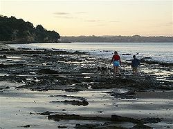
The peninsula stretches east for 11 kilometres into the waters of the Hauraki Gulf
Hauraki Gulf
The Hauraki Gulf is a coastal feature of the North Island of New Zealand. It has a total area of 4000 km², and lies between the Auckland Region, the Hauraki Plains, the Coromandel Peninsula and Great Barrier Island...
to the north of East Coast Bays
East Coast Bays
East Coast Bays is the collective name for a series of small suburbs of North Shore City, in the Auckland metropolitan area of New Zealand, which line the northeast coast of the city along the shore of the Hauraki Gulf and Rangitoto Channel...
. The island of Tiritiri Matangi
Tiritiri Matangi Island
Tiritiri Matangi Island lies in the Hauraki Gulf of New Zealand, east of the Whangaparaoa Peninsula in the North Island and north east of Auckland. The island is an open nature reserve managed under the supervision of the Department of Conservation and is noted for its bird life, including kiwi...
lies three kilometres off its eastern tip. The town of Whangaparaoa sits on the peninsula's southwestern shore, and is regarded as the start of the section of coastline known as the Hibiscus Coast.
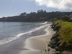
Communities along the peninsula include Red Beach
Red Beach
Red Beach is a suburb and beach on the Hibiscus Coast, Orewa, New Zealand. State Highway 1 runs through the suburb, but the majority of traffic travels along the Northern motorway inland instead, and the motorway will be redesignated as State Highway 1 when an extension is complete in 2009.The...
, Stanmore Bay
Stanmore Bay
Stanmore Bay is a suburb and beach on the Whangaparaoa Peninsula, in the Auckland Region of New Zealand. The beach is on the northern side of the peninsula.The population was 5,007 in the 2006 Census, an increase of 405 from 2001.-Education:...
, Big Manly, Tindalls Beach, Army Bay, Gulf Harbour, Matakatia, Little Manly, and Arkles Bay. At the end of the peninsula is Shakespear Regional Park
Shakespear Regional Park
Shakespear Regional Park is a nature park in the Auckland Region of New Zealand. It is located at the tip of the Whangaparaoa Peninsula, and is named after the Shakespear family which bought the land in the 1880s from local Maori....
. The New Zealand Defence Force also owns part of this area, which has been used as a resettlement camp for refugees.
In the past ten years a township has developed on the high land above Stanmore Bay and Big Manly beach. This development includes a shopping centre, a movie theatre, a bowling alley and a library and community centre. While the area was once relatively remote, the shopping facilities, including a large supermarket, have made living on the extremities of the peninsula more convenient, especially as the central city is now no more than forty minutes from this centre during off-peak periods.
Association football
Whangaparaoa Peninsula is home to football (soccer) club Hibiscus Coast AFCHibiscus Coast AFC
Hibiscus Coast A.F.C is a semi-professional football club from Whangaparaoa Peninsula, New Zealand. They compete in the Lotto Sport Italia NRFL Division 2.Their home ground is at Stanmore Bay Park in the Hibiscus Coast region....
who compete in the Lotto Sport Italia NRFL Division 2
Lotto Sport Italia NRFL Division 2
The Lotto Sport Italia NRFL Division 2 is a New Zealand Association football semi-professional status league competition that is run by the Auckland Football Federation and includes soccer clubs located in the northern part of the North Island, New Zealand. It is open to clubs from the Northland,...
.
Transportation
Hibiscus CoastHibiscus Coast
The Hibiscus Coast is a stretch of the Hauraki Gulf coast located in New Zealand's Rodney District, 10 minutes north of the former North Shore City by car. It contains the northernmost part of the Auckland metropolitan area....
is served by NorthStar Bus Routes offering an extensive range of destinations including Auckland City
Auckland City
Auckland City was the city and local authority covering the Auckland isthmus and most of the islands of the Hauraki Gulf, in the North Island of New Zealand. On 1 November 2010 it was amalgamated into the wider Auckland Region under the authority of the new Auckland Council...
.
There are also Ferry services 360* Discovery and MAXX Fuller Ferries which commute between Gulf Harbour
Gulf Harbour
Gulf Harbour is a development some 4 km from the end of the Whangaparaoa Peninsula, towards the northern end of Auckland, New Zealand. It has one of the country's largest marinas, one of the country's top golf courses, and is regarded as a retreat for Auckland's well-off...
and The surrounding islands including Auckland
Auckland
The Auckland metropolitan area , in the North Island of New Zealand, is the largest and most populous urban area in the country with residents, percent of the country's population. Auckland also has the largest Polynesian population of any city in the world...
City Daily.
Education
Whangaparaoa College - Known as the former Intermediate School, Hibiscus CoastHibiscus Coast
The Hibiscus Coast is a stretch of the Hauraki Gulf coast located in New Zealand's Rodney District, 10 minutes north of the former North Shore City by car. It contains the northernmost part of the Auckland metropolitan area....
Intermediate, Whangaparaoa College Is a very modern new school which offers state of the art facilities. It Formed from the Intermediate in 2005. 2009 has been the first year for the college to have all years 7 to 13 attending. It has become Whangaparaoa Peninsula's main college.
Other Schools in the area:
- Wentworth College (Gulf HarbourGulf HarbourGulf Harbour is a development some 4 km from the end of the Whangaparaoa Peninsula, towards the northern end of Auckland, New Zealand. It has one of the country's largest marinas, one of the country's top golf courses, and is regarded as a retreat for Auckland's well-off...
) - Whangaparaoa Primary
- Stanmore Bay Primary
- Gulf HarbourGulf HarbourGulf Harbour is a development some 4 km from the end of the Whangaparaoa Peninsula, towards the northern end of Auckland, New Zealand. It has one of the country's largest marinas, one of the country's top golf courses, and is regarded as a retreat for Auckland's well-off...
School - Red BeachRed BeachRed Beach is a suburb and beach on the Hibiscus Coast, Orewa, New Zealand. State Highway 1 runs through the suburb, but the majority of traffic travels along the Northern motorway inland instead, and the motorway will be redesignated as State Highway 1 when an extension is complete in 2009.The...
Primary - Orewa College