
Devonport, New Zealand
Encyclopedia
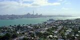
Devonport is a harbourside suburb of Auckland
, New Zealand
. It is located on the North Shore, at the southern end of a peninsula that runs southeast from near Lake Pupuke
in Takapuna
, forming the northern side of the Waitemata Harbour
. East of Devonport lies North Head
, the northern promontory guarding the mouth of the harbour.
The population of Devonport and the adjoining suburb of Cheltenham
was 5,337 in the 2006 Census
, an increase of 126 since 2001.
With the additional suburbs of Stanley Bay
, Vauxhall
and Narrow Neck
, the 2006 population was 11,142.
The suburb hosts the Devonport Naval Base
of the Royal New Zealand Navy
, the main facility for the country's naval vessels, but is best known for its harbourside dining and drinking establishments and its heritage charm. In its scenery and setting, Devonport has been compared to Sausalito, California
.
In 2011 the Devonport community, led by parents and local publication the Devonport Flagstaff, launched a grassroots movement protesting the sale of the synthetic cannabis Kronic in local dairies. The battle was a success, and Kronic was banned from the area.
Day trips combining a meal in Devonport with a trip up Mt Victoria or an exploration of the military emplacements on nearby North Head are also very popular. Devonport is also noted for the popular annual event, the Devonport Food & Wine Festival, as well as for the Devonport Museum located near Mt. Cambria.
The navy base at Devonport features strongly in the local character, with the North Shore City Council having signed a Memorandum of Understanding with the Navy which recognises the developing partnership between them.
and between them Mount Cambria
(now largely quarried away).
The earliest evidence for (Māori) settlement dates from the mid-14th century (roughly during the same time as the supposed landing of the Tainui waka
which is commemorated by a stone memorial on the foreshore). The last remaining significant Māori settlement in the area, on North Head
, was wiped out by rival tribes in the 1790s.
Jules Dumont d'Urville
, a French explorer, is thought to have gone ashore in the area in 1827, possibly as the first European. The first permanent European inhabitant was a pilot and harbour master stationed on North Head
in 1836. The suburb of Devonport itself was first settled in 1840 and is one of the oldest in Auckland and the first on the North Shore. It was initially called Flagstaff because of the flagstaff raised on nearby Mount Victoria (Takarunga)
. For the first half century or so of its existence Devonport was geographically isolated from the rest of the North Shore, and was sometimes called "the island" by the local inhabitants. Only a thin strip of land beside the beach at Narrow Neck connected Devonport to Belmont and the rest of the North Shore peninsula. In the late 19th century the mangrove
swamp that stretched from Narrow Neck to Ngataringa Bay was filled in to form a racecourse, now a golf course. A new road was built along the western edge of the racecourse allowing more direct travel to the north.
On the southern shore, to the west of the centre of Devonport, a nearby deep water anchorage suitable for Royal Navy
vessels, the Devonport Naval Base
was established. William Hobson
, then the Governor of New Zealand, considered the sandspit-protected area a better choice for a naval installation than the shallower Tamaki
waters on the southern side of the harbour. While some facilities have expanded and shifted in location over time, the area is still the primary base for the Royal New Zealand Navy
. The Calliope Dock at Stanley Bay
, part of the base, was opened on 16 February 1888 and at the time was the largest dock in the Southern hemisphere
. The suburb also had one of the oldest New Zealand shipyards, now part of the Devonport Yacht Club area.
The main centre of the suburb slowly shifted west from Church Street and the original wharf at Torpedo Bay, to its current location around the ferry wharf. The settlement itself was renamed Devonport by 1859 after the English
naval town of Devonport
. Devonport achieved Borough
status in 1886 and was incorporated into North Shore City in 1989.
services to Auckland city began in the 1840s These were open sailing cutters operated by local seamen running passengers to the foot of Queen Street
Auckland's main road. In 1860 the first paddlesteamer ferries began operation.
These were in turn replaced by double-ended, screw-driven ferries in 1904. Both passenger and vehicle ferries operated on the Devonport run until the opening of the Auckland Harbour Bridge
in 1959. Immediately after the opening of the bridge passenger ferry services to other North Shore destinations (such as Northcote
and Birkenhead
) were cancelled as were all vehicular ferries. The Devonport passenger ferry was retained on a much reduced timetable. The majority of the ferries were scrapped, only a handful being retained until being replaced by more modern vessels. The last of the old-style double-ended ferries, the diesel-engined Kestrel (built in 1905), was retired from the commuter run in 1988 and was then operated for cruises and sightseeing. In 2002 the Kestrel was moved to Tauranga to serve as a floating restaurant. The Kestrel has since changed hands again and moved back to Auckland, currently residing at the Auckland City ferry terminal.
Today, ferry services, subsidised by the Auckland Regional Transport Authority, are more numerous again. A crossing between the Auckland CBD
and Devonport takes about 12 minutes, usually on the 'Seabus Kea
', a newer double-ended ferry.
The Devonport Wharf / Ferry Terminal received a variety of maintenance and repairs during 2011 in advance of the Rugby World Cup. Further structural works are to be carried out in 2012.
 Between the wharf and Mt Victoria is located the Devonport shops, the most prominent landmarks of which are:
Recently, in July 2007, Devonport was given permission to be excluded from a list of local Auckland growth node centres. The Auckland Regional Council
accepted that while it was encouraging intensified growth (such as higher-density housing) around transport nodes such as Devonport, the character and historical nature of the Devonport Wharf area would make such a designation inappropriate in this case.
 Devonport School, St Leo's School and AppleTree Education Centre are coeducational primary schools with rolls of 312, 124 and 22 respectively. Devonport School and St Leo's School have decile rating
s of 10 and provide education for years 1-6. St Leo's is a state integrated Catholic school. AppleTree Education Centre is an independent school established with a curriculum focusing on the development of multiple human intelligences
for students in years 1-8. It moved to its current premises in 2004.
Auckland
The Auckland metropolitan area , in the North Island of New Zealand, is the largest and most populous urban area in the country with residents, percent of the country's population. Auckland also has the largest Polynesian population of any city in the world...
, New Zealand
New Zealand
New Zealand is an island country in the south-western Pacific Ocean comprising two main landmasses and numerous smaller islands. The country is situated some east of Australia across the Tasman Sea, and roughly south of the Pacific island nations of New Caledonia, Fiji, and Tonga...
. It is located on the North Shore, at the southern end of a peninsula that runs southeast from near Lake Pupuke
Lake Pupuke
Lake Pupuke is a heart-shaped freshwater lake occupying a volcanic explosion crater between the suburbs of Takapuna and Milford on the North Shore of Auckland, New Zealand. The heart shape is a result of its formation by the linking of two circular craters - a larger one forming most of the lake...
in Takapuna
Takapuna
Takapuna is a central, coastal suburb of North Shore City, located in the northern North Island of New Zealand, at the beginning of a south-east-facing peninsula forming the northern side of the Waitemata Harbour...
, forming the northern side of the Waitemata Harbour
Waitemata Harbour
The quite famous Waitemata Harbour is the main access by sea to Auckland, New Zealand. For this reason it is often referred to as Auckland Harbour, despite the fact that it is only one of two harbours surrounding the city, and is crossed by the Auckland Harbour Bridge. The Waitemata forms the north...
. East of Devonport lies North Head
North Head, New Zealand
North Head is a volcanic cone forming a headland within North Shore City, New Zealand, in the suburb of Devonport at the east end of the Waitemata Harbour ....
, the northern promontory guarding the mouth of the harbour.
The population of Devonport and the adjoining suburb of Cheltenham
Cheltenham, New Zealand
Cheltenham is North-Eastern suburb of Auckland, New Zealand. It gets its name from the English town of Cheltenham, and has a magnificent view of Rangitoto Island from its beachfront areas. The suburb is in the North Shore ward, one of the thirteen administrative divisions of the city of Auckland....
was 5,337 in the 2006 Census
New Zealand Census of Population and Dwellings
The New Zealand government department Statistics New Zealand conducts a census of population and dwellings every five years. The census scheduled for 2011 was cancelled due to circumstances surrounding the February 2011 Christchurch earthquake, however, and legislation introduced to hold the next...
, an increase of 126 since 2001.
With the additional suburbs of Stanley Bay
Stanley Bay, New Zealand
Stanley Bay on the North Shore, New Zealand is a small suburb near Devonport. It is mostly residential; the surrounding towns and shops are only a walk away...
, Vauxhall
Vauxhall, Auckland
Vauxhall is a suburb of North Shore City, Auckland, New Zealand. Alison Park lies directly to the east, separating Vauxhall from Lake Road which carries the majority of traffic between Takapuna and Devonport....
and Narrow Neck
Narrow Neck, New Zealand
- to the south-east - to the south - to the west - to the north-west Hauraki GulfVauxhall Devonport Bayswater Belmont Narrow Neck is a suburb of Auckland, New Zealand....
, the 2006 population was 11,142.
The suburb hosts the Devonport Naval Base
Devonport Naval Base
Devonport Naval Base is the home of the Royal New Zealand Navy, located at Devonport, New Zealand on Auckland's North Shore. It is currently the only base of the navy that operates ships, and was a navy base from as far back as 1841...
of the Royal New Zealand Navy
Royal New Zealand Navy
The Royal New Zealand Navy is the maritime arm of the New Zealand Defence Force...
, the main facility for the country's naval vessels, but is best known for its harbourside dining and drinking establishments and its heritage charm. In its scenery and setting, Devonport has been compared to Sausalito, California
Sausalito, California
Sausalito is a San Francisco Bay Area city, in Marin County, California, United States. Sausalito is south-southeast of San Rafael, at an elevation of 13 feet . The population was 7,061 as of the 2010 census. The community is situated near the northern end of the Golden Gate Bridge, and prior to...
.
In 2011 the Devonport community, led by parents and local publication the Devonport Flagstaff, launched a grassroots movement protesting the sale of the synthetic cannabis Kronic in local dairies. The battle was a success, and Kronic was banned from the area.
Character
The Devonport shops contain a fair array of antiques, gift & book shops as well a number of good cafes and restaurants making it a popular destination for tourists and Aucklanders. People often travel over from Auckland on the ferry for dinner, the starry sky and glittering lights of Auckland on the return trip being very beautiful.Day trips combining a meal in Devonport with a trip up Mt Victoria or an exploration of the military emplacements on nearby North Head are also very popular. Devonport is also noted for the popular annual event, the Devonport Food & Wine Festival, as well as for the Devonport Museum located near Mt. Cambria.
The navy base at Devonport features strongly in the local character, with the North Shore City Council having signed a Memorandum of Understanding with the Navy which recognises the developing partnership between them.
Overview
Around 40,000 years ago Devonport consisted of three islands of volcanic origin, Mount Victoria, North HeadNorth Head, New Zealand
North Head is a volcanic cone forming a headland within North Shore City, New Zealand, in the suburb of Devonport at the east end of the Waitemata Harbour ....
and between them Mount Cambria
Mount Cambria
Mount Cambria is one of the volcanoes in the Auckland Volcanic Field. Located north-east of Mt Victoria, it's 30m scoria cone was quarried away. The site is now Cambria Reserve...
(now largely quarried away).
The earliest evidence for (Māori) settlement dates from the mid-14th century (roughly during the same time as the supposed landing of the Tainui waka
Waka (canoe)
Waka are Māori watercraft, usually canoes ranging in size from small, unornamented canoes used for fishing and river travel, to large decorated war canoes up to long...
which is commemorated by a stone memorial on the foreshore). The last remaining significant Māori settlement in the area, on North Head
North Head, New Zealand
North Head is a volcanic cone forming a headland within North Shore City, New Zealand, in the suburb of Devonport at the east end of the Waitemata Harbour ....
, was wiped out by rival tribes in the 1790s.
Jules Dumont d'Urville
Jules Dumont d'Urville
Jules Sébastien César Dumont d'Urville was a French explorer, naval officer and rear admiral, who explored the south and western Pacific, Australia, New Zealand and Antarctica.-Childhood:Dumont was born at Condé-sur-Noireau...
, a French explorer, is thought to have gone ashore in the area in 1827, possibly as the first European. The first permanent European inhabitant was a pilot and harbour master stationed on North Head
North Head, New Zealand
North Head is a volcanic cone forming a headland within North Shore City, New Zealand, in the suburb of Devonport at the east end of the Waitemata Harbour ....
in 1836. The suburb of Devonport itself was first settled in 1840 and is one of the oldest in Auckland and the first on the North Shore. It was initially called Flagstaff because of the flagstaff raised on nearby Mount Victoria (Takarunga)
Mount Victoria, Auckland
Mount Victoria is the highest volcano on Auckland's North Shore, rising to 87 m. Its age is currently unknown. Its lava flows now line much of Devonport's waterfront...
. For the first half century or so of its existence Devonport was geographically isolated from the rest of the North Shore, and was sometimes called "the island" by the local inhabitants. Only a thin strip of land beside the beach at Narrow Neck connected Devonport to Belmont and the rest of the North Shore peninsula. In the late 19th century the mangrove
Mangrove
Mangroves are various kinds of trees up to medium height and shrubs that grow in saline coastal sediment habitats in the tropics and subtropics – mainly between latitudes N and S...
swamp that stretched from Narrow Neck to Ngataringa Bay was filled in to form a racecourse, now a golf course. A new road was built along the western edge of the racecourse allowing more direct travel to the north.
On the southern shore, to the west of the centre of Devonport, a nearby deep water anchorage suitable for Royal Navy
Royal Navy
The Royal Navy is the naval warfare service branch of the British Armed Forces. Founded in the 16th century, it is the oldest service branch and is known as the Senior Service...
vessels, the Devonport Naval Base
Devonport Naval Base
Devonport Naval Base is the home of the Royal New Zealand Navy, located at Devonport, New Zealand on Auckland's North Shore. It is currently the only base of the navy that operates ships, and was a navy base from as far back as 1841...
was established. William Hobson
William Hobson
Captain William Hobson RN was the first Governor of New Zealand and co-author of the Treaty of Waitangi.-Early life:...
, then the Governor of New Zealand, considered the sandspit-protected area a better choice for a naval installation than the shallower Tamaki
Tamaki, New Zealand
Tamaki is a small suburb of the city of Auckland, in the North Island of New Zealand. It is located in the east of the city, 11 kilometres from the city centre, by the banks of the estuarial Tamaki River, which is a southern arm of the Hauraki Gulf...
waters on the southern side of the harbour. While some facilities have expanded and shifted in location over time, the area is still the primary base for the Royal New Zealand Navy
Royal New Zealand Navy
The Royal New Zealand Navy is the maritime arm of the New Zealand Defence Force...
. The Calliope Dock at Stanley Bay
Stanley Bay, New Zealand
Stanley Bay on the North Shore, New Zealand is a small suburb near Devonport. It is mostly residential; the surrounding towns and shops are only a walk away...
, part of the base, was opened on 16 February 1888 and at the time was the largest dock in the Southern hemisphere
Southern Hemisphere
The Southern Hemisphere is the part of Earth that lies south of the equator. The word hemisphere literally means 'half ball' or "half sphere"...
. The suburb also had one of the oldest New Zealand shipyards, now part of the Devonport Yacht Club area.
The main centre of the suburb slowly shifted west from Church Street and the original wharf at Torpedo Bay, to its current location around the ferry wharf. The settlement itself was renamed Devonport by 1859 after the English
England
England is a country that is part of the United Kingdom. It shares land borders with Scotland to the north and Wales to the west; the Irish Sea is to the north west, the Celtic Sea to the south west, with the North Sea to the east and the English Channel to the south separating it from continental...
naval town of Devonport
Devonport, Devon
Devonport, formerly named Plymouth Dock or just Dock, is a district of Plymouth in the English county of Devon, although it was, at one time, the more important settlement. It became a county borough in 1889...
. Devonport achieved Borough
Borough
A borough is an administrative division in various countries. In principle, the term borough designates a self-governing township although, in practice, official use of the term varies widely....
status in 1886 and was incorporated into North Shore City in 1989.
Ferries
The first ferryFerry
A ferry is a form of transportation, usually a boat, but sometimes a ship, used to carry primarily passengers, and sometimes vehicles and cargo as well, across a body of water. Most ferries operate on regular, frequent, return services...
services to Auckland city began in the 1840s These were open sailing cutters operated by local seamen running passengers to the foot of Queen Street
Queen Street, Auckland
Queen Street is the major commercial thoroughfare in the Auckland CBD, Auckland, New Zealand's main population centre. It starts at Queens Wharf on the Auckland waterfront, adjacent to the Britomart Transport Centre and the Downtown Ferry Terminal, and runs uphill for almost three kilometres in a...
Auckland's main road. In 1860 the first paddlesteamer ferries began operation.
These were in turn replaced by double-ended, screw-driven ferries in 1904. Both passenger and vehicle ferries operated on the Devonport run until the opening of the Auckland Harbour Bridge
Auckland Harbour Bridge
The Auckland Harbour Bridge is an eight-lane box truss motorway bridge over the Waitemata Harbour, joining St Marys Bay in Auckland with Northcote in North Shore City, New Zealand. The bridge is part of State Highway 1 and the Auckland Northern Motorway...
in 1959. Immediately after the opening of the bridge passenger ferry services to other North Shore destinations (such as Northcote
Northcote, New Zealand
Northcote is a suburb of North Shore City, one of several cities in the Auckland metropolitan area in northern New Zealand. It is located on the north shore of the Waitemata Harbour, four kilometres northwest of the Auckland city centre....
and Birkenhead
Birkenhead, New Zealand
Birkenhead is a suburb of Auckland, in northern New Zealand. It is located on the north shore of the Waitemata Harbour, four kilometres northwest of the Auckland city centre....
) were cancelled as were all vehicular ferries. The Devonport passenger ferry was retained on a much reduced timetable. The majority of the ferries were scrapped, only a handful being retained until being replaced by more modern vessels. The last of the old-style double-ended ferries, the diesel-engined Kestrel (built in 1905), was retired from the commuter run in 1988 and was then operated for cruises and sightseeing. In 2002 the Kestrel was moved to Tauranga to serve as a floating restaurant. The Kestrel has since changed hands again and moved back to Auckland, currently residing at the Auckland City ferry terminal.
Today, ferry services, subsidised by the Auckland Regional Transport Authority, are more numerous again. A crossing between the Auckland CBD
Auckland CBD
The Auckland CBD is the geographical and economic heart of the Auckland metropolitan area. Bounded by several major motorways and by the harbour coastline in the north, it is surrounded further out by mostly suburban areas...
and Devonport takes about 12 minutes, usually on the 'Seabus Kea
Seabus Kea
M.V. Kea is a commercial passenger ferry that operates the busy Devonport-Downtown Auckland express route for Fullers Ferries . The Kea operates a regular service departing from Downtown Auckland every half hour...
', a newer double-ended ferry.
The Devonport Wharf / Ferry Terminal received a variety of maintenance and repairs during 2011 in advance of the Rugby World Cup. Further structural works are to be carried out in 2012.
Notable locations
- The Devonport Wharf; rebuilt in the 1990s and about to be redeveloped.
- The Esplanade Hotel; This is an elegant example of an 1890s seaside hotel, reminiscent of many an English seaside resort of the period. Recently restored.
- King Edward Parade Reserve; here are located the 1970s Public Library, the War Memorial [a bronze soldier figure] and under the Morton Bay Fig trees a charming 1950s styled bandstand.
- The Victoria Cinema; Built in 1912 and remodelled in the 1930s internally and externally in the fashionable Art Deco Style, this is apparently the oldest cinema in the Southern hemisphere in continuous use. Victoria Cinema has since opened after renovations, having recently (2006) been purchased by the North Shore City Council on behalf of the city.
Recently, in July 2007, Devonport was given permission to be excluded from a list of local Auckland growth node centres. The Auckland Regional Council
Auckland Regional Council
The Auckland Regional Council was the regional council of the Auckland Region. Its predecessor the Auckland Regional Authority was formed in 1963 and became the ARC in 1989...
accepted that while it was encouraging intensified growth (such as higher-density housing) around transport nodes such as Devonport, the character and historical nature of the Devonport Wharf area would make such a designation inappropriate in this case.
Notable people
- Dove-Myer RobinsonDove-Myer RobinsonSir Dove-Myer Robinson was Mayor of Auckland City from 1959 to 1965 and from 1968 to 1980, the longest tenure of any holder of the office....
, a former Auckland Mayor, attended Devonport Primary School. - Isabel Maude Peacocke, teacher, novelist, broadcaster, born in Devonport in 1881.
- Tom AshleyTom AshleyThomas John Mitchell Ashley, ONZM is a sailor from New Zealand, who won the gold medal in the men's sailboard event at the 2008 Summer Olympics, he also won the 2008 RS:X World Championships. He is the Olympic champion and the 2008 World champion...
, Boardsailing Olypic Gold medallist - Sir Peter BlakePeter Blake (yachtsman)Sir Peter James Blake, KBE was a New Zealand yachtsman who won the Whitbread Round the World Race, the Jules Verne Trophy – setting the fastest time around the world of 74 days 22 hours 17 minutes 22 seconds on catamaran Enza, and led his country to successive victories in the America’s Cup...
, attended Bayswater Primary School, Takapuna Grammar School
Education
Socio-Economic Decile
Decile, Socio-Economic Decile or Socio-Economic Decile Band is a widely used measure in education in New Zealand used to target funding and support to more needy schools....
s of 10 and provide education for years 1-6. St Leo's is a state integrated Catholic school. AppleTree Education Centre is an independent school established with a curriculum focusing on the development of multiple human intelligences
Theory of multiple intelligences
The theory of multiple intelligences was proposed by Howard Gardner in 1983 as a model of intelligence that differentiates intelligence into various specific modalities, rather than seeing it as dominated by a single general ability....
for students in years 1-8. It moved to its current premises in 2004.