

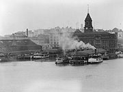
Auckland waterfront
Encyclopedia
Waitemata Harbour
The quite famous Waitemata Harbour is the main access by sea to Auckland, New Zealand. For this reason it is often referred to as Auckland Harbour, despite the fact that it is only one of two harbours surrounding the city, and is crossed by the Auckland Harbour Bridge. The Waitemata forms the north...
coastline in Auckland City
Auckland City
Auckland City was the city and local authority covering the Auckland isthmus and most of the islands of the Hauraki Gulf, in the North Island of New Zealand. On 1 November 2010 it was amalgamated into the wider Auckland Region under the authority of the new Auckland Council...
, New Zealand
New Zealand
New Zealand is an island country in the south-western Pacific Ocean comprising two main landmasses and numerous smaller islands. The country is situated some east of Australia across the Tasman Sea, and roughly south of the Pacific island nations of New Caledonia, Fiji, and Tonga...
. Previously mostly dominated by Ports of Auckland
Ports of Auckland
Ports of Auckland Limited , the successor to the Auckland Harbour Board, is the company administering Auckland's commercial freight and cruise ship harbour facilities...
uses, from the 2000s on it is becoming increasingly open to recreational public use, with a number of former wharves being converted to office, entertainment, and later also some residential uses.
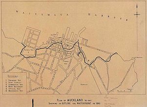
Extents
The waterfront stretches roughly from the suburb of Saint Marys BaySaint Marys Bay, New Zealand
Saint Marys Bay is an Auckland suburb- 1800s :mid-1840s George Scott farms the land where 3 Lamps is now.1853 For £1100 Catholic Bishop Pompallier purchases 19ha in the area between 3 lamps and the shoreline from James O’Neill christening it Mount St. Mary.1854 O’Neill’s house becomes St. Anne’s...
/ the Auckland Harbour Bridge
Auckland Harbour Bridge
The Auckland Harbour Bridge is an eight-lane box truss motorway bridge over the Waitemata Harbour, joining St Marys Bay in Auckland with Northcote in North Shore City, New Zealand. The bridge is part of State Highway 1 and the Auckland Northern Motorway...
in the west to the Ports of Auckland
Ports of Auckland
Ports of Auckland Limited , the successor to the Auckland Harbour Board, is the company administering Auckland's commercial freight and cruise ship harbour facilities...
areas in the east. However, in most usage, 'Auckland waterfront' only refers to those parts freely accessible to the public (such as around the Viaduct Basin
Viaduct Basin
Viaduct Basin is a former commercial harbour on the Auckland waterfront, now turned into a development of mostly upscale apartments, office space and restaurants. It is located on the site of a formerly run-down area of the Freemans Bay / Auckland CBD waterfront in Auckland City, New Zealand...
and the Auckland CBD
Auckland CBD
The Auckland CBD is the geographical and economic heart of the Auckland metropolitan area. Bounded by several major motorways and by the harbour coastline in the north, it is surrounded further out by mostly suburban areas...
), and thus at the moment excludes much of the Western Reclamation
Western Reclamation
The Wynyard Quarter is a reclaimed piece of land on the Waitemata Harbour at the western edge of the Auckland waterfront, New Zealand....
and almost the whole of the Ports of Auckland area to the east.
While Auckland City technically has a second waterfront on the Manukau Harbour
Manukau Harbour
Manukau Harbour is the second largest natural harbour in New Zealand by area. It is located to the southwest of the Auckland isthmus, and is an arm of the Tasman Sea.-Geography:...
, this is never called 'Auckland waterfront'.
Future
During 2006, a prolonged public discussion about the future of the waterfront was begun, first by the start of public consultationPublic consultation
Public consultation, or simply consultation, is a regulatory process by which the public's input on matters affecting them is sought. Its main goals are in improving the efficiency, transparency and public involvement in large-scale projects or laws and policies...
on the future of the Western Reclamation
Western Reclamation
The Wynyard Quarter is a reclaimed piece of land on the Waitemata Harbour at the western edge of the Auckland waterfront, New Zealand....
, then by the plans for Stadium New Zealand
Stadium New Zealand
Stadium New Zealand, often called the Waterfront Stadium, was the provisional name for a national stadium proposed for Auckland's waterfront to host the 2011 Rugby World Cup. The stadium never advanced beyond a concept design....
on the land of Ports of Auckland
Ports of Auckland
Ports of Auckland Limited , the successor to the Auckland Harbour Board, is the company administering Auckland's commercial freight and cruise ship harbour facilities...
. While the plans for Stadium New Zealand were eventually scrapped (partly because of complaints of some citizens that it would block harbour views, but mostly due to its effect on port operations), the discussion had shown that Aucklanders would prefer greater access to the waterfront, which is at the moment is still industrial land / port land in large areas.
However, Ports of Auckland (the company still owning most of the Auckland wharves
Wharf
A wharf or quay is a structure on the shore of a harbor where ships may dock to load and unload cargo or passengers.Such a structure includes one or more berths , and may also include piers, warehouses, or other facilities necessary for handling the ships.A wharf commonly comprises a fixed...
) noted that while it will explore plans for greater public access, it needed most of the space for the foreseeable future. As most of the Western Reclamation will not see any immediate transformation (due to ongoing commercial lease
Leasing
Leasing is a process by which a firm can obtain the use of a certain fixed assets for which it must pay a series of contractual, periodic, tax deductible payments....
s and required decontamination before future use), the sights are currently set on extending the public areas of the Viaduct Basin with a new entertainment strip along Jellicoe St to the west of it. This is to be linked by a bridge to the Viaduct and the Auckland CBD, with the bridge design possibly being internationally tendered, and for all works to be completed in time for the Rugby World Cup 2011.
Queens Wharf
In early 2008, ARCAuckland Regional Council
The Auckland Regional Council was the regional council of the Auckland Region. Its predecessor the Auckland Regional Authority was formed in 1963 and became the ARC in 1989...
plans were unveiled that may see Queens Wharf, the wharf closest to the Auckland Ferry Terminal
Auckland Ferry Terminal
The Auckland Ferry Terminal, sometimes called the Downtown Ferry Terminal, is the hub of the Auckland ferry network that connects Auckland City with North Shore City and some locations in Waitakere City and Manukau City. The ferry terminal is in the Auckland CBD on the Auckland waterfront...
, converted into public space. Currently the wharf is used to store ripening bananas and hold import cars before fumigation treatment by Ministry of Agriculture and Forestry
Ministry of Agriculture and Forestry (New Zealand)
The Ministry of Agriculture and Forestry is the state sector organisation of New Zealand which deals with matters relating to agriculture, forestry and biosecurity...
staff. However, plans for the specific activities are still up in the air, though a new cruise ship
Cruise ship
A cruise ship or cruise liner is a passenger ship used for pleasure voyages, where the voyage itself and the ship's amenities are part of the experience, as well as the different destinations along the way...
terminal, to support the heavily booked Princes Wharf
Princes Wharf
Princes Wharf is a former commercial wharf on the Auckland waterfront, in Auckland City, New Zealand, which has been redeveloped into a multi-story high-class mixed-use development and cruise ship terminal....
terminal, seems likely to be part of the mix.
Commentators have remarked that the wharf has been open to the public before during its early working life, when loading took place next to strolling members of the public, recreational fishing and other uses, a kind of life as on a "European square", and that the authorities should try to recreate such a feeling by providing for compatible mixed uses. The Yokohama Passenger Terminal
Osanbashi Pier
is the main international pier at the Port of Yokohama, located in Naka Ward, Yokohama, Japan. Ōsanbashi is the oldest pier in Yokohama, originally constructed between 1889 and 1896.To meet modern demands, Ōsanbashi was reconstructed between 1987 and 2002...
was held up as an example, with port, ferry and customs/immigration facilities contained within a wharf, and with a sweeping public park on the roof of the structure.
Economic future
A 2010 report by PricewaterhouseCoopersPricewaterhouseCoopers
PricewaterhouseCoopers is a global professional services firm headquartered in London, United Kingdom. It is the world's largest professional services firm measured by revenues and one of the "Big Four" accountancy firms....
projected that up to 2040, the waterfront would generate $4.29 billion for the economy of the region, and about 13,600 people could be employed in waterfront businesses by that time.
See also
- Auckland CBDAuckland CBDThe Auckland CBD is the geographical and economic heart of the Auckland metropolitan area. Bounded by several major motorways and by the harbour coastline in the north, it is surrounded further out by mostly suburban areas...
- Auckland Ferry TerminalAuckland Ferry TerminalThe Auckland Ferry Terminal, sometimes called the Downtown Ferry Terminal, is the hub of the Auckland ferry network that connects Auckland City with North Shore City and some locations in Waitakere City and Manukau City. The ferry terminal is in the Auckland CBD on the Auckland waterfront...
- Auckland Ferry Terminal
- Bays or former bays:
- Commercial BayCommercial BayCommercial Bay was the bay on the southern side of the Waitemata Harbour, formerly defining the original extent of the Auckland waterfront, Auckland, New Zealand...
(reclaimed former bay, now the site of the Auckland CBD) - Freemans BayFreemans BayFreemans Bay is the name of a former bay and now inner city suburb of Auckland, in the North Island of New Zealand. The historical bay was filled in to a large extent, and lost its shoreline to reclamation works...
(reclaimed former bay, now a suburb without waterfront access, blocked by the Viaduct Basin suburb) - Mechanics BayMechanics BayMechanics Bay is the name of a former bay on the Waitemata Harbour in Auckland City, New Zealand. It is also the name used to describe the area of the former bay that is now mainly occupied by commercial and port facilities...
(reclaimed former bay, now a suburb without waterfront access, blocked by the Port of Auckland)
- Commercial Bay
- Ports of AucklandPorts of AucklandPorts of Auckland Limited , the successor to the Auckland Harbour Board, is the company administering Auckland's commercial freight and cruise ship harbour facilities...
(commercial users of the eastern waterfront)- Stadium New ZealandStadium New ZealandStadium New Zealand, often called the Waterfront Stadium, was the provisional name for a national stadium proposed for Auckland's waterfront to host the 2011 Rugby World Cup. The stadium never advanced beyond a concept design....
(formerly proposed large sports stadium on the waterfront)
- Stadium New Zealand
- Princes WharfPrinces WharfPrinces Wharf is a former commercial wharf on the Auckland waterfront, in Auckland City, New Zealand, which has been redeveloped into a multi-story high-class mixed-use development and cruise ship terminal....
(upmarket residential area and cruise ship terminal) - Viaduct BasinViaduct BasinViaduct Basin is a former commercial harbour on the Auckland waterfront, now turned into a development of mostly upscale apartments, office space and restaurants. It is located on the site of a formerly run-down area of the Freemans Bay / Auckland CBD waterfront in Auckland City, New Zealand...
(former fishing and marine use quarter turned into upmarket residential area) - Western ReclamationWestern ReclamationThe Wynyard Quarter is a reclaimed piece of land on the Waitemata Harbour at the western edge of the Auckland waterfront, New Zealand....
(western industrial area to become a public park and residential area) - Westhaven MarinaWesthaven MarinaWesthaven Marina in Auckland, New Zealand, is the largest yacht marina in the Southern Hemisphere. The marina has nearly two thousand berths and swing moorings, and tends to be continually booked...
(west of the Western Reclamation, a large recreational / yachting marina)