

Victoria Park, Auckland
Encyclopedia
Auckland City
Auckland City was the city and local authority covering the Auckland isthmus and most of the islands of the Hauraki Gulf, in the North Island of New Zealand. On 1 November 2010 it was amalgamated into the wider Auckland Region under the authority of the new Auckland Council...
, New Zealand
New Zealand
New Zealand is an island country in the south-western Pacific Ocean comprising two main landmasses and numerous smaller islands. The country is situated some east of Australia across the Tasman Sea, and roughly south of the Pacific island nations of New Caledonia, Fiji, and Tonga...
. It lies on reclaimed bay land in Freemans Bay
Freemans Bay
Freemans Bay is the name of a former bay and now inner city suburb of Auckland, in the North Island of New Zealand. The historical bay was filled in to a large extent, and lost its shoreline to reclamation works...
, a suburb directly west of the Auckland CBD
Auckland CBD
The Auckland CBD is the geographical and economic heart of the Auckland metropolitan area. Bounded by several major motorways and by the harbour coastline in the north, it is surrounded further out by mostly suburban areas...
. This origin of the land makes it very flat and level. However, it does not have direct connection to the foreshore anymore, as the Western Reclamation
Western Reclamation
The Wynyard Quarter is a reclaimed piece of land on the Waitemata Harbour at the western edge of the Auckland waterfront, New Zealand....
and the Viaduct Basin
Viaduct Basin
Viaduct Basin is a former commercial harbour on the Auckland waterfront, now turned into a development of mostly upscale apartments, office space and restaurants. It is located on the site of a formerly run-down area of the Freemans Bay / Auckland CBD waterfront in Auckland City, New Zealand...
quarter lie between it and the Waitemata Harbour
Waitemata Harbour
The quite famous Waitemata Harbour is the main access by sea to Auckland, New Zealand. For this reason it is often referred to as Auckland Harbour, despite the fact that it is only one of two harbours surrounding the city, and is crossed by the Auckland Harbour Bridge. The Waitemata forms the north...
.
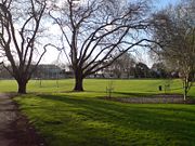
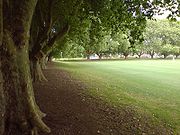
It is surrounded by London plane trees on all sides (planted in 1905 for the opening of the park), which provide an oval frame for the sports fields in the middle. However, urban expansion and traffic needs have not fully bypassed the park, and it is bordered by some of the busier Auckland arterials on the north (Fanshaw Street) and south (Victoria Street), as well as having State Highway 1 pass overhead on a four-lane viaduct
Viaduct
A viaduct is a bridge composed of several small spans. The term viaduct is derived from the Latin via for road and ducere to lead something. However, the Ancient Romans did not use that term per se; it is a modern derivation from an analogy with aqueduct. Like the Roman aqueducts, many early...
in the western part of the park.
Major close-by attractions are the Victoria Park Market
Victoria Park Market
Victoria Park Market is a craft, souvenir and clothing market and retail complex in Auckland, New Zealand. It is housed in a former waste depot and incinerator complex. The Market is located in Freemans Bay and takes its name from nearby Victoria Park...
, an old rubbish incinerator (once known as the Destructor) now housing an arts & crafts market and several entertainment venues. The market was to receive a major makeover in the late 2000s, which would have seen many of the older buildings restored (and some of the smaller stores merged for larger tenancies), while the carpark on the northern end of the site was to be moved underground and apartments built in its stead. However, this project seems to have been delayed or cancelled.
The suburb also has New World
New World (supermarket)
New World is a New Zealand full-service supermarket chain owned by the Foodstuffs cooperative.Founded in 1963, New World was the first American-style full-service supermarket brand of Foodstuffs, and the second in New Zealand...
Victoria Park, one of only two large supermarkets in the whole of the CBD area, while Westhaven Marina
Westhaven Marina
Westhaven Marina in Auckland, New Zealand, is the largest yacht marina in the Southern Hemisphere. The marina has nearly two thousand berths and swing moorings, and tends to be continually booked...
lies close by to the north.
History
The following information is mostly derived from an Auckland City timeline:- The public park was first mooted at a Council meeting in 1884, and eventually it was opened in 1905 by the mayor Arthur MyersArthur MyersSir Arthur Mielziner Myers was a New Zealand politician. He was Mayor of Auckland City from 1905 to 1909, Member of the House of Representatives from 1910 to 1921, and a Cabinet Minister...
, with the first grandstandGrandstandA grandstand is a large and normally permanent structure for seating spectators, most often at a racetrack. This includes both auto racing and horse racing. The grandstand is in essence like a single section of a stadium, but differs from a stadium in that it does not wrap all or most of the way...
pavillon opened a year later.
- It has been the home ground of the Ponsonby PoniesPonsonby PoniesThe Ponsonby Ponies are a rugby league club based in Ponsonby, New Zealand. The club was founded in 1908 and competes in the Auckland Rugby League's Fox Memorial competition.-History:...
rugby league club since their foundation in 1908.
- Asphalt tennis courts followed in 1909, with bowling greenBowling greenA bowling green is a finely-laid, close-mown and rolled stretch of lawn for playing the game of lawn bowls.Before 1830, when Edwin Beard Budding invented the lawnmower, lawns were often kept cropped by grazing sheep on them...
s, croquetCroquetCroquet is a lawn game, played both as a recreational pastime and as a competitive sport. It involves hitting plastic or wooden balls with a mallet through hoops embedded into the grass playing court.-History:...
lawns and a playgroundPlaygroundA playground or play area is a place with a specific design for children be able to play there. It may be indoors but is typically outdoors...
added later. In 1907 and 1911 and 1911 the park was also extended both west and east.
- In 1910 'Campbell Free Kindergarten' opens in the western part of the park, with funds from Sir John Logan CampbellJohn Logan CampbellSir John Logan Campbell was a prominent New Zealand public figure. He was the son of Doctor John Campbell and his wife Catherine. He was described by his contemporaries as "the father of Auckland".- Early life:...
and Lady Campbell. This building was later used by a sports club, and is owned by Auckland City Council, but fell into disrepair and has not had a tenant for two decades as of 2010, crumbling aways slowly. However, in June 2010 it was announced that NZTANew Zealand Transport AgencyThe New Zealand Transport Agency is a New Zealand Crown entity tasked with promoting safe and functional transport by land, including the responsibility for driver and vehicle licensing and investigating rail accidents. It was created on 1 August 2008 by the Land Transport Management Amendment...
and Council had reached an agreement whereby some Vic Park TunnelVictoria Park ViaductThe Victoria Park Viaduct is a major motorway viaduct carrying the Auckland Northern Motorway over the Victoria Park area in Auckland City, New Zealand...
control equipment would be housed in a refurbished building provided as a legacy feature, with a 100-people occupancy community space on the ground floor.
- Victoria Park was the site if the first ever match of international rugby leagueRugby leagueRugby league football, usually called rugby league, is a full contact sport played by two teams of thirteen players on a rectangular grass field. One of the two codes of rugby football, it originated in England in 1895 by a split from Rugby Football Union over paying players...
played on New Zealand soil when Great BritainGreat Britain national rugby league teamThe Great Britain national rugby league team represents the United Kingdom in rugby league football. Administered by the Rugby Football League , the team is nicknamed "The Lions" or "Great Britain Lions"....
played against the New Zealand Maori team on 20 July as part of their first ever tour of Australasia1910 Great Britain Lions tour of Australia and New ZealandThe 1910 Great Britain Lions tour of Australia and New Zealand was the first international tour of the Great Britain national rugby league team, "The Lions". They played the second ever Ashes series against Australia before travelling to Auckland to take on New Zealand...
.
- During the Second World WarWorld War IIWorld War II, or the Second World War , was a global conflict lasting from 1939 to 1945, involving most of the world's nations—including all of the great powers—eventually forming two opposing military alliances: the Allies and the Axis...
, the park was used for accommodation of US Armed Forces and covered with temporary huts. In the early 1950s, the park escaped closure and industrial redevelopment after it was decided that the facility was of regional use and the provision of parks in the outer suburbs would not suffice to replace it.
- In 1960, the kindergarten moves to Tahuna Street, with the building now occupied jointly by Grafton United Cricket Club, Ponsonby Soccer Club and the Pipe Band. The building is later abandoned (around the 1980s, with the building now (2007) derelict).
- In 1962 the State Highway 1State Highway 1 (New Zealand)State Highway 1 is the longest and most significant road in the New Zealand roading network, running the length of both main islands. It appears on road maps as SH 1 and on road signs as a white number 1 on a red shield, but it has the official designations SH 1N in the North Island, SH 1S in the...
motorway extension through the park (on an elevated roadway) becomes the first completed section of the inner city transport plan. Later plans to widen the viaduct (which by now is the narrowest part of the motorway in the Auckland area) meet resistance, as it is feared that this would further despoil the park it bisects. Currently (2007), the plan is for a tunnel to be built underneath the park to carry the additional lanes.
- In 1989 Auckland City receives ownership of Victoria Park from the Auckland Harbour Board, exchanging it for stub roads used for wharf access in Viaduct Basin.
Tunnel plans
One, possibly two tunnels are currently planned underneath Victoria Park. With the 4-lane Victoria Park Viaduct being one of the bottlenecks of traffic through the Auckland area, and towards the Auckland Harbour BridgeAuckland Harbour Bridge
The Auckland Harbour Bridge is an eight-lane box truss motorway bridge over the Waitemata Harbour, joining St Marys Bay in Auckland with Northcote in North Shore City, New Zealand. The bridge is part of State Highway 1 and the Auckland Northern Motorway...
, Transit New Zealand
Transit New Zealand
Transit New Zealand was, from 1989 to 2008, the New Zealand Crown entity responsible for operating and planning the New Zealand State Highway network...
has decided to widen the section of SH1
State Highway 1 (New Zealand)
State Highway 1 is the longest and most significant road in the New Zealand roading network, running the length of both main islands. It appears on road maps as SH 1 and on road signs as a white number 1 on a red shield, but it has the official designations SH 1N in the North Island, SH 1S in the...
going through the park. As a second viaduct was not considered viable, the new lanes will be added underground from 2012 on. There is also talk of a future tunnel from a second harbour crossing underneath the Tank Farm
Western Reclamation
The Wynyard Quarter is a reclaimed piece of land on the Waitemata Harbour at the western edge of the Auckland waterfront, New Zealand....
possibly joining the motorway near the southern side of the park.