

Thorntoun house and estate
Encyclopedia
Thorntoun School was opened by Barnardo's
in September 1971 for children with emotional difficulties aged 11 to 16 years. The school closed in 1990 and Thorntoun is now a Nursing Home
. The complex lies between the villages of Springside
(North Ayrshire) and Crosshouse, Kilmarnock
in East Ayrshire
, Scotland
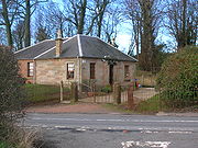
. The old Thorntoun mansion house was demolished in the late 1940s, leaving the West Lodge, some of the home farm outbuildings, the stables and the walled garden as 'memorials' to the ancient history of the site. Many fine trees remain from the estate policies and the surviving gardens are very well maintained (2007). An entrance with a slight deviation from the old course has been created to serve the large modern buildings which house the nursing home.
 In 1866 James Paterson , another historian, brought up locally, gives 'Thorntoun' as "This property, situated to the west of Busbie (Knockentiber
), is about 300 acres (1.2 km²) in extent. It belonged, of old, according to Wood, to one of the branches of the Montgomerie family."
|- style="text-align:center;"
|Etymology
|- style="text-align:left; font-size:x-medium;"
|Near Thorntoun in 1604 was a Thornhill. This fact, combined with the consistent spelling over the years suggests that the name relates to 'Thorns' i.e., either Blackthorn
(Sloe) or Hawthorn. Both species are still common in the area today. A 'Toun' or 'Ton' was a farm and its outbuildings, originally an area fenced or walled off, with a dwelling within.
|}
Thorntoun was at first part of the Barony of Kilmaurs
and then later it was placed within the Barony of Robertoun, Parish of Kilmaurs. The estate is first recorded as belonging to Murthhaw or Murchaw de Montgomery
, who is mentioned in the Ragman's Roll
(a list of those loyal to Edward I of England) of 1296. A Johne of Montgomery of Thornetoun is mentioned in a legal document of 1482, forfeiting the estate to Lord Home by order of King James V. By the beginning of the seventeenth century Thorntoun had passed into the ownership of another ancient and renowned Ayrshire family, the Mures (or Muirs), a branch of the Mures of Rowallan Castle
near Kilmaurs
. James Mure, Burgess of Glasgow, had married Margaret, a daughter of Robert Ross of Thorntoun on June 27, 1607 and inherited the property through his spouse. Nothing is known of how and when the Ross's, another ancient Ayrshire family, had come to possess Thorntoun. Hew (Hugh) was one son, a merchant in Edinburgh, his will is dated 4 Nov 1679 and another son, James succeeded to the property of Thorntoun, and married a Janet Naper, who died in 1626. Robert Muir, son of James & Janet, is mentioned in a document of 1634.
in 1698 and his only daughter, Margaret, married John Cuninghame of Caddel, in the Parish of Ardrossan
, in 1699. They inherited Thorntoun and Caddel and had two sons and three daughters. Archibald succeeded his father and John became a successful merchant in Lisbon
(Portugal), eventually retiring to live at Carmelbank (previously called Mote), adjacent to Thorntoun. Their father was married a second time to a daughter of Mr. Stevenson of Montgreenan, by whom they had another sixteen children. This John Cuninghame died in 1753.
 Archibald Cuninghame, who was a captain in Boscawen's 29th. Regiment of Foot, married Christiana, eldest daughter of Andrew Macredie of Perceton
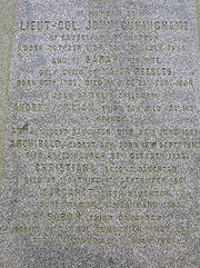
in 1754. They had three sons, John, Andrew and Archibald and five daughters. Their eldest son was Lieut-Col. John Cuninghame, born in 1756 and died in 1836. He entered the army in 1775 and served in America (now the USA) and the West Indies. He was severely wounded whilst fighting the French in the Caribbean island of St. Kitts. John recovered to serve on board the 74 gun, HMS Montague, at the great Caribbean naval victory of the Battle of the Saintes
against the French who were commanded by Admiral Count François Joseph Paul de Grasse
. He left the army as a lieutenant-colonel in 1802. John's spouse was Sarah Peebles, only daughter of Major John Peebles in Irvine, late of the 42nd regiment, She was born in 1783 and died in 1854. They had nine children, Andrew, John, Archibald, Anna, Christiana, Helen, Margaret, Catherine and Sarah. Many of the family died in childhood or when relatively young. Catherine married Clarence Esme Stuart of Oldenham Abbey, Hertfordshire
. Christiana first inherited, followed by Sarah. The colonels' rental value of the property in 1799 was £300 (Scots) per annum, compared with that of the Earl of Eglinton
, who had an income of £1,120 (Scots) from his estates. The Lieut-Col and his family are commemorated and / or buried at the family burial plot in the cemetery of Kilmaurs-Glencairn kirk.
 Sarah Cuninghame's spouse was George Bourchier Wrey from North Devon
. They had a son, George Edward Bourchier Wrey who had succeeded to the property by 1912. He appears to have inherited Carmelbank from his great-uncle, John Cuninghame by this date. The combined rental income of Thorntoun and Carmelbank was £2,640 12s 0d., the second highest in the parish, only exceeded by Robert Morris Pollock-Morris of Craig house. This is a reversal for both of the situation in 1799 and may reflect earnings from the establishment of collieries, etc. rather than the straightforward 'traditional' income from farms and the like.
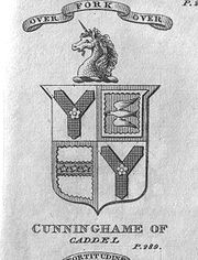
are a 'shake fork' with a 'cinq foil', for Glengarnock: a cross 'maline', within a Bordure invectee, for Caddel: three stars within a border invectee for Muir of Thorntoun and a crest of a Unicorn's head erect. The motto is 'Over fork over' and as such is unchaged from that of the senior branch, the Cunninghames of Kilmaurs, Earls of Glencairn
.
 The Darien Company was an attempt by the Scots to set up a trading colony in America in the late 1690s, however the opposition from England and elsewhere was so great that the attempt failed with huge losses and great financial implications for the country and for individuals. Half of the whole circulating capital of Scotland was subscribed and mostly lost. In Cunninghame some examples of losses are Sir Archibald Mure of Thorntoun (£1000), Major James Cunninghame of Aiket (£200), Sir William Cunninghame of Cunninghamhead (£1000), William Watson of Tour (£150) and James Thomson of Hill in Kilmaurs (£100). In modern terms a thousand pounds loss in the 17th century must have been a devastating blow to the family finances.
In 1780 Captain John Peebles noted in his journal the "General Rules for Manouvring the Battn. by the Commanding Officer"; appended to these directions are a series of signals for giving orders to the troops -
Preparative, to begin firing by Companies, which is to go on as fast as each is loaded till the first part of the General when not a shot more is ever to be fired.
Grenadrs. March. to advance in Line.
Point of War. to Charge.
To Arms. to form the Battn. (whether advancing or Retreating in Column) upon the leading division.
Double flam. to halt Upon the word forward, in forming, the Divisions to run up in Order.15
Monday 22d. June rain in the night The Army... moved on to the Black Horse a small Village about 7 or 8 miles from Mount holly & Encampd in two lines facing NW—Genl. Kniphausens Division on the left—the Queens Rangers on our Right... Maxwells Corps of Rebels left the Black horse this Morng.
Sunday 28 June a fight... (This was the Battle of Monmouth
!).
Monday 29th. June … Genl. Knyphausens Division moved on to Middletown, with the Provision & baggage Train - & wounded.
's map of 1604 as published by Johan Blaeu in 1654 clearly marks Thorntoun so do Ainslie's map of 1821, Armstrong's map of 1775 and Herman Moll's map of The Shire of Renfrew with Cuningham in 1745. General Roy's Military Survey map of Scotland (1745–55) shows the site named as simply 'Thorn'.
 Thomson's map of 1828 gives some detail, showing two entrances and driveways, with substantial woodlands and an enclosed park on the Springside boundary, as used for deer or cattle. He also marks the name 'Mains', indicating the home farm, apparently situated to the right of the house on the 'east' driveway on the Crosshouse side..This was later rebuilt above the 'West' Lodge (1898 OS), however buildings remain in the 'old' site up until the time of the 1921-28 OS map. This map also indicates a building roughly in the centre of the walled garden. The walls show no signs of typical conservatory-style greenhouses built against them, so this may be a large 'greenhouse'. The stone is red sandstone
with freestone corners and coping stones. The materials were landed at Troon
harbour and brought here by cart. A 'trig point
' is carved on the corner of the walled garden nearest the old quarry.. A well is shown near the walled garden in the vicinity of the modern housing. An old freestone quarry is shown on the 1860 map, close to the trig point
on the walled garden. Buildings are indicated on the 1912 OS map as lying fairy close to the northern wall of the walled gardens. Only vague foundations and scattered stones now exist at the site in 2007.
The 1912 map appears to show an enclosed area, partially wooded, in the nearby field, of a similar size and shape to the walled garden. This may be a fox covert or cover for pheasants. No sign of this feature is now extant (2007).
A small cottage used to stand near the entrance to the new driveway into the nursing home. The 1912 map shows a track running into the estate at this point and this building may have served as a lodge house. The name 'West Lodge' itself suggests that a second lodge existed at one time and the 1911 OS clearly marks this lodge situated at what is now the realigned entrance to the main driveway.
A number of local names appear to have been lost, such as Thornhill (1604), Greenside, Hayside, and Laurieslaw from 1828 and Montgomery Holme (1745–1828). A Laurieland Row, Crawfurdhill and Thorntoun Row were present in 1860. A Thornyhill cottage is however present (2007) near Busbiehill.
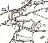
The Royal Mail
re-organised its postal districts in the 1930s and at that point many hamlets and localities ceased to exist officially, such as Sprighill, Corsehill, Bankhead and Kirklands. The present Springside was called Bankhead up until at least the 1921 - 1928 OS, the hamlet of Springside being originally clustered around the railway station.
A number of Lime kilns are marked on 1860 OS, the nearest being at Holme and West Gatehead farms.
 In 1776 Thorntoun is marked on the toll road to Irvine and the two milestones are shown.
A horse trough was present on the left of the main road facing Springside, in between the West Lodge and the lane up to Thorntoun Mains; the trough has long vanished, but its niche in the bank with its side walls is still there. This was a turnpike
or Toll road, with the nearest Toll house
located at Crosshouse. The 1860 OS map show two milestones were near Thorntoun, one close to the junction of the lane down to Hallbarns and Cauldhame farms and the other on the left facing Crosshouse, before the Holm Burn bridge, indicating 4 miles (6.4 km) to Irvine and three to Kilmarnock
. Most milestones were buried during the Second World War so as not to provide assistance to invading troops, German spies, etc. This happened all over Scotland, however Fife
at least was more fortunate than Ayrshire, for the stones were taken into storage and put back in place after the war had finished.
The name 'Turnpike' originated from the original 'gate' used being just a simple wooden bar attached at one end to a hinge on the supporting post. The hinge allowed it to 'open' or 'turn' This bar looked like the 'pike' used as a weapon in the army at that time and therefore we get 'turnpike'. The term was also used by the military for barriers set up on roads specifically to prevent the passage of horses. In addition to providing better surfaces and more direct routes, the turnpikes settled the confusion of the different lengths given to miles, which varied from 4,854 to nearly 7000 feet (2,133.6 m). Long miles, short miles, Scotch or Scot's miles (5,928 ft), Irish miles (6,720 ft), etc. all existed. 5280 feet (1,609.3 m) seems to have been an average! Another important point is that when these new toll roads were constructed the Turnpike Trusts went to a great deal of trouble to improve the route of the new road and these changes could be quite considerable as the old roads tended to go from farm to farm, hardly the shortest route. The tolls on roads were abolished in 1878 to be replaced by a road 'assessment', which was taken over by the County Council in 1889.
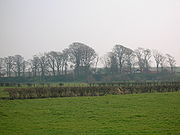
.jpg) The woodland policies contain a mixture of mature oak, Norway maple, beech, copper beech, willow, horse chestnut, aspen, rhododendron, Scots pine, alder, ash, elm, monkey puzzle, willow, sycamore, holy, elder, yew, lime, hawthorn, blackthorn and other species. The woodland floor has drifts of snowdrops, bluebells and some primroses, together with ground ivy, bird's-foot trefoil, coltsfoot, three-veined sandwort, vetch, ladys mantle, red campion, bistort, foxgloves, tuberous comfrey, ivy, yellow saxifrage, pendulous sedge, brambles, etc. An area of the woodland is a genuine 'bluebell wood.' The large leaved Persian Ivy
The woodland policies contain a mixture of mature oak, Norway maple, beech, copper beech, willow, horse chestnut, aspen, rhododendron, Scots pine, alder, ash, elm, monkey puzzle, willow, sycamore, holy, elder, yew, lime, hawthorn, blackthorn and other species. The woodland floor has drifts of snowdrops, bluebells and some primroses, together with ground ivy, bird's-foot trefoil, coltsfoot, three-veined sandwort, vetch, ladys mantle, red campion, bistort, foxgloves, tuberous comfrey, ivy, yellow saxifrage, pendulous sedge, brambles, etc. An area of the woodland is a genuine 'bluebell wood.' The large leaved Persian Ivy
(Hedera colchica) grows at the walled garden, a relict of the exotic plantings of yesteryear, as is the very unusual stand of Butcher's Broom. The ground flora of the Thorntoun policies is typical of the semi-natural diversity of many deciduous woodlands in Ayrshire, particularly of those associated with current or previous country estates. The bird fauna is quite diverse, including pigeons, rooks, starlings, blackbirds, kestrels, etc. Hedgehogs are present (2007).
mineral railway lines, criss-crossing the countryside; they all now lifted, with only a few embankments left to indicate their original course. The Thorntoun colliery beside Holme farm had a miner's row and a railway which ran over several wooden bridges down to join the surviving railway through Gatehead at Holm ley
, close to the Laigh Milton viaduct
. In 1860 numerous old and current coal pits dotted the area. The bing of Springhill (Pit No.3) still lies close to Springside in the field that may have been the Thorntoun deer park.
 Strawhorn
states in 1951 that a fair number of inhabitants are of Cornish extraction, having been brought up here to break a coal workers strike in the 1880s.
The road running down to Springside is known as the 'Thorntoun Brae' and on the left, just before Thorntoun bridge over the Garrier Burn was the local curling pond, clearly marked on the 1911 OS map
A mill-wand was the rounded piece of wood acting as an axle with which several people would role a millstone form the quarry to the mill and to permit this the width of some early roads was set at a 'mill-wand breadth'. The nearest mills to Thorntoun were those at Busbie beside Crosshouse and Laigh Milton mill, where the building, weir and part of the wheel still exist (2007).
Margaret Muir, was the spouse of Frederick Cunninghame, a merchant in Kilmarnock
. She died on 17 March 1685 and could therefore have been a daughter of James Mure and Janet Naper.
One of the bells in St Giles Cathedral in Edinburgh
is inscribed "Archibald Mure, Thorntoun, Lord Provost"
In 1902 a Mrs. Margaret Sturrock, née Finnie was living at Thorntoun House.
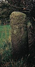
A Trig point
at the walled garden marks a height of 169 feet (51.5 m) elevation above sea level.
Letters survive in the National Archives of Scotland concerning the imprisonment of Margaret Cuninghame at Lucca
in Tuscany
, Italy
for evangelical teaching, 1853-1854.
The Cuninghames of Thorntoun & Caddel held title to lands in Ayr
and tenements in Glasgow, 1573–1836,
including, tack
s of lands in Stirling
.
The estate factors' accounts of Caddell and Thorntoun, survive for the period 1700-1947. Thorntoun house may have been demolished in 1947.
Sir Philip Bourchier Sherard Wrey stood for election to the Southern Rhodesia
legislative council in 1920.
Mr Cunningham attended the famous 1839 Eglinton Tournament in what is now Eglinton Country Park
and he was alloted a seat in the Grand Stand.
Barnardo's
Barnardo's is a British charity founded by Thomas John Barnardo in 1866, to care for vulnerable children and young people. As of 2010, it spends over £190 million each year on more than 400 local services aimed at helping these same groups...
in September 1971 for children with emotional difficulties aged 11 to 16 years. The school closed in 1990 and Thorntoun is now a Nursing Home
Nursing home
A nursing home, convalescent home, skilled nursing unit , care home, rest home, or old people's home provides a type of care of residents: it is a place of residence for people who require constant nursing care and have significant deficiencies with activities of daily living...
. The complex lies between the villages of Springside
Springside
Springside may refer to:*Springside, Ayrshire, a village in Scotland*Springside , estate of Matthew Vassar with landscaped grounds in Poughkeepsie, New York, U.S.A....
(North Ayrshire) and Crosshouse, Kilmarnock
Kilmarnock
Kilmarnock is a large burgh in East Ayrshire, Scotland, with a population of 44,734. It is the second largest town in Ayrshire. The River Irvine runs through its eastern section, and the Kilmarnock Water passes through it, giving rise to the name 'Bank Street'...
in East Ayrshire
East Ayrshire
East Ayrshire is one of 32 council areas of Scotland. It borders on to North Ayrshire, East Renfrewshire, South Lanarkshire, South Ayrshire and Dumfries and Galloway...
, Scotland
Scotland
Scotland is a country that is part of the United Kingdom. Occupying the northern third of the island of Great Britain, it shares a border with England to the south and is bounded by the North Sea to the east, the Atlantic Ocean to the north and west, and the North Channel and Irish Sea to the...
. The old Thorntoun mansion house was demolished in the late 1940s, leaving the West Lodge, some of the home farm outbuildings, the stables and the walled garden as 'memorials' to the ancient history of the site. Many fine trees remain from the estate policies and the surviving gardens are very well maintained (2007). An entrance with a slight deviation from the old course has been created to serve the large modern buildings which house the nursing home.
The History of Thorntoun house and estate
In 1823 the historian Robertson describes "Thornton" as being "situated about half way betwixt Irvine and Kilmarnock: the manor or place (palace) is an elegant modern mansion, set down on the brow of a considerable height, overlooking, from amid its fine old timber and more recent plantings, a great expanse of rich country."Knockentiber
Knockentiber is a village in East Ayrshire, Parish of Kilmaurs, Scotland. Knockentiber is WNW of Kilmarnock and 1/2 mile NE of Crosshouse. Latitude:55.6193°N Longitude:4.5455°W and . The population was 359 in 1991, however the population is much higher following the construction of several...
), is about 300 acres (1.2 km²) in extent. It belonged, of old, according to Wood, to one of the branches of the Montgomerie family."
The Montgomerie, Mure and Ross families
{|style="float:left; margin:1em 1em 1em 1em; width:27em; border: 1px solid #a0a0a0; padding: 10px; background-color: #F5F5F5; text-align:left;"|- style="text-align:center;"
|Etymology
|- style="text-align:left; font-size:x-medium;"
|Near Thorntoun in 1604 was a Thornhill. This fact, combined with the consistent spelling over the years suggests that the name relates to 'Thorns' i.e., either Blackthorn
Blackthorn
Prunus spinosa is a species of Prunus native to Europe, western Asia, and locally in northwest Africa. It is also locally naturalised in New Zealand and eastern North America....
(Sloe) or Hawthorn. Both species are still common in the area today. A 'Toun' or 'Ton' was a farm and its outbuildings, originally an area fenced or walled off, with a dwelling within.
|}
Thorntoun was at first part of the Barony of Kilmaurs
Kilmaurs
Kilmaurs is a village in East Ayrshire, Scotland. It lies on the Carmel, 21.1 miles south by west of Glasgow. Population recorded in 2001 Census, 2601- History :...
and then later it was placed within the Barony of Robertoun, Parish of Kilmaurs. The estate is first recorded as belonging to Murthhaw or Murchaw de Montgomery
Montgomery
-In France:* Sainte-Foy-de-Montgommery, a commune in département Calvados, Normandy* Saint-Germain-de-Montgommery, idem* Colleville-Montgomery, idem-In Pakistan:...
, who is mentioned in the Ragman's Roll
Ragman
Ragman is a fictional mystic vigilante and superhero who first appeared in the short-lived comic-book series named after him. He is one of a limited number of Jewish superheroes, and his continuity is tied to that of DC Comics' Golem, derived from the Golem of Prague of Jewish folklore.Ragman is...
(a list of those loyal to Edward I of England) of 1296. A Johne of Montgomery of Thornetoun is mentioned in a legal document of 1482, forfeiting the estate to Lord Home by order of King James V. By the beginning of the seventeenth century Thorntoun had passed into the ownership of another ancient and renowned Ayrshire family, the Mures (or Muirs), a branch of the Mures of Rowallan Castle
Thomas Corbett, 2nd Baron Rowallan
Thomas Godfrey Polson Corbett, 2nd Baron Rowallan, KT, KBE, MC, TD , had a distinguished military career, was Chief Scout of the British Commonwealth and Empire and Governor of Tasmania.-Early life:...
near Kilmaurs
Kilmaurs
Kilmaurs is a village in East Ayrshire, Scotland. It lies on the Carmel, 21.1 miles south by west of Glasgow. Population recorded in 2001 Census, 2601- History :...
. James Mure, Burgess of Glasgow, had married Margaret, a daughter of Robert Ross of Thorntoun on June 27, 1607 and inherited the property through his spouse. Nothing is known of how and when the Ross's, another ancient Ayrshire family, had come to possess Thorntoun. Hew (Hugh) was one son, a merchant in Edinburgh, his will is dated 4 Nov 1679 and another son, James succeeded to the property of Thorntoun, and married a Janet Naper, who died in 1626. Robert Muir, son of James & Janet, is mentioned in a document of 1634.
The Cuninghame Family
Archibald Muir of Thorntoun was knighted by King William IIIWilliam III of England
William III & II was a sovereign Prince of Orange of the House of Orange-Nassau by birth. From 1672 he governed as Stadtholder William III of Orange over Holland, Zeeland, Utrecht, Guelders, and Overijssel of the Dutch Republic. From 1689 he reigned as William III over England and Ireland...
in 1698 and his only daughter, Margaret, married John Cuninghame of Caddel, in the Parish of Ardrossan
Ardrossan
Ardrossan is a town on the North Ayrshire coast in south-western Scotland. The name "Ardrossan" describes its physical position — 'ard' from the Gaelic àird meaning headland, 'ros' a promontory and the diminutive suffix '-an' - headland of the little promontory...
, in 1699. They inherited Thorntoun and Caddel and had two sons and three daughters. Archibald succeeded his father and John became a successful merchant in Lisbon
Lisbon
Lisbon is the capital city and largest city of Portugal with a population of 545,245 within its administrative limits on a land area of . The urban area of Lisbon extends beyond the administrative city limits with a population of 3 million on an area of , making it the 9th most populous urban...
(Portugal), eventually retiring to live at Carmelbank (previously called Mote), adjacent to Thorntoun. Their father was married a second time to a daughter of Mr. Stevenson of Montgreenan, by whom they had another sixteen children. This John Cuninghame died in 1753.
Perceton
Perceton is a medieval settlement and estate in North Ayrshire, Scotland, near the town of Irvine. The old church in Perceton is one of the oldest buildings in the Irvine district...
in 1754. They had three sons, John, Andrew and Archibald and five daughters. Their eldest son was Lieut-Col. John Cuninghame, born in 1756 and died in 1836. He entered the army in 1775 and served in America (now the USA) and the West Indies. He was severely wounded whilst fighting the French in the Caribbean island of St. Kitts. John recovered to serve on board the 74 gun, HMS Montague, at the great Caribbean naval victory of the Battle of the Saintes
Battle of the Saintes
The Battle of the Saintes took place over 4 days, 9 April 1782 – 12 April 1782, during the American War of Independence, and was a victory of a British fleet under Admiral Sir George Rodney over a French fleet under the Comte de Grasse forcing the French and Spanish to abandon a planned...
against the French who were commanded by Admiral Count François Joseph Paul de Grasse
François Joseph Paul de Grasse
Lieutenant Général des Armées Navales François-Joseph Paul, marquis de Grasse Tilly, comte de Grasse was a French admiral. He is best known for his command of the French fleet at the Battle of the Chesapeake, which led directly to the British surrender at Yorktown...
. He left the army as a lieutenant-colonel in 1802. John's spouse was Sarah Peebles, only daughter of Major John Peebles in Irvine, late of the 42nd regiment, She was born in 1783 and died in 1854. They had nine children, Andrew, John, Archibald, Anna, Christiana, Helen, Margaret, Catherine and Sarah. Many of the family died in childhood or when relatively young. Catherine married Clarence Esme Stuart of Oldenham Abbey, Hertfordshire
Hertfordshire
Hertfordshire is a ceremonial and non-metropolitan county in the East region of England. The county town is Hertford.The county is one of the Home Counties and lies inland, bordered by Greater London , Buckinghamshire , Bedfordshire , Cambridgeshire and...
. Christiana first inherited, followed by Sarah. The colonels' rental value of the property in 1799 was £300 (Scots) per annum, compared with that of the Earl of Eglinton
Earl of Eglinton
Earl of Eglinton is a title in the Peerage of Scotland.Some authorities spell the title: Earl of Eglintoun In 1859 the thirteenth Earl of Eglinton, Archibald Montgomerie, was also created Earl of Winton in the Peerage of the United Kingdom, which gave him an automatic seat in the House of Lords,...
, who had an income of £1,120 (Scots) from his estates. The Lieut-Col and his family are commemorated and / or buried at the family burial plot in the cemetery of Kilmaurs-Glencairn kirk.
The Wrey Family
North Devon
North Devon is the northern part of the English county of Devon. It is also the name of a local government district in Devon. Its council is based in Barnstaple. Other towns and villages in the North Devon District include Braunton, Fremington, Ilfracombe, Instow, South Molton, Lynton and Lynmouth...
. They had a son, George Edward Bourchier Wrey who had succeeded to the property by 1912. He appears to have inherited Carmelbank from his great-uncle, John Cuninghame by this date. The combined rental income of Thorntoun and Carmelbank was £2,640 12s 0d., the second highest in the parish, only exceeded by Robert Morris Pollock-Morris of Craig house. This is a reversal for both of the situation in 1799 and may reflect earnings from the establishment of collieries, etc. rather than the straightforward 'traditional' income from farms and the like.
Coat of arms
The Coat of ArmsCoat of arms
A coat of arms is a unique heraldic design on a shield or escutcheon or on a surcoat or tabard used to cover and protect armour and to identify the wearer. Thus the term is often stated as "coat-armour", because it was anciently displayed on the front of a coat of cloth...
are a 'shake fork' with a 'cinq foil', for Glengarnock: a cross 'maline', within a Bordure invectee, for Caddel: three stars within a border invectee for Muir of Thorntoun and a crest of a Unicorn's head erect. The motto is 'Over fork over' and as such is unchaged from that of the senior branch, the Cunninghames of Kilmaurs, Earls of Glencairn
Earl of Glencairn
The title of Earl of Glencairn was created in the Peerage of Scotland in 1488 for the first Lord Kilmaurs .On the death of the fifteenth earl in 1796, there existing no original Letters Patent of the creation nor a given remainder in the various confirmations in title of previous earls the title...
.
The Barony of Robertoun
This barony, once part of the Barony of Kilmaurs, ran from Kilmaurs south to the river Irvine. It had no manor house and belonged to the Eglinton family latterly. The following properties were part of the barony: parts of Kilmaurs, Craig, Gatehead, Woodhills, Greenhill, Altonhill, Plann, Hayside, Thorntoun, Rash-hill Park, Milton, Windyedge, Fardelhill, Muirfields, Corsehouse and Knockentiber.The Darien Affair
The Journals of Major John Peebles
Located in the Cuninghame of Thorntoun Papers in the National Archives of Scotland is the American Revolution journal of Captain John Peebles (1739–1823), a grenadier officer of the 42nd (Royal Highland Regiment or Black Watch). The journal provides an enlightening insight into the life and activities of the British army during the rebellion. John Peebles was John Cuninghame's father-in-law.In 1780 Captain John Peebles noted in his journal the "General Rules for Manouvring the Battn. by the Commanding Officer"; appended to these directions are a series of signals for giving orders to the troops -
Signals by Drum
The following extracts illustrate the battlefield manoeuvres which drum 'signals' could signal -Preparative, to begin firing by Companies, which is to go on as fast as each is loaded till the first part of the General when not a shot more is ever to be fired.
Grenadrs. March. to advance in Line.
Point of War. to Charge.
To Arms. to form the Battn. (whether advancing or Retreating in Column) upon the leading division.
Double flam. to halt Upon the word forward, in forming, the Divisions to run up in Order.15
The New Jersey Brigade and the Monmouth Campaign
Here are a few extracts from John's American War of Independence journal -Monday 22d. June rain in the night The Army... moved on to the Black Horse a small Village about 7 or 8 miles from Mount holly & Encampd in two lines facing NW—Genl. Kniphausens Division on the left—the Queens Rangers on our Right... Maxwells Corps of Rebels left the Black horse this Morng.
Sunday 28 June a fight... (This was the Battle of Monmouth
Battle of Monmouth
The Battle of Monmouth was an American Revolutionary War battle fought on June 28, 1778 in Monmouth County, New Jersey. The Continental Army under General George Washington attacked the rear of the British Army column commanded by Lieutenant General Sir Henry Clinton as they left Monmouth Court...
!).
Monday 29th. June … Genl. Knyphausens Division moved on to Middletown, with the Provision & baggage Train - & wounded.
Evidence from Ordnance Survey (OS) and other maps
Timothy PontTimothy Pont
Timothy Pont was a Scottish topographer, the first to produce a detailed map of Scotland. Pont's maps are among the earliest surviving to show a European country in minute detail, from an actual survey.-Life:...
's map of 1604 as published by Johan Blaeu in 1654 clearly marks Thorntoun so do Ainslie's map of 1821, Armstrong's map of 1775 and Herman Moll's map of The Shire of Renfrew with Cuningham in 1745. General Roy's Military Survey map of Scotland (1745–55) shows the site named as simply 'Thorn'.
Sandstone
Sandstone is a sedimentary rock composed mainly of sand-sized minerals or rock grains.Most sandstone is composed of quartz and/or feldspar because these are the most common minerals in the Earth's crust. Like sand, sandstone may be any colour, but the most common colours are tan, brown, yellow,...
with freestone corners and coping stones. The materials were landed at Troon
Troon
Troon is a town in South Ayrshire. It is situated on the west coast of Scotland, about eight miles north of Ayr and three miles northwest of Glasgow Prestwick International Airport. Lying across the Firth of Clyde, the Isle of Arran can be seen. Troon is also a port with freight and ferry services...
harbour and brought here by cart. A 'trig point
Trig point
A triangulation station, also known as a triangulation pillar, trigonometrical station, trigonometrical point, trig station, trig beacon or trig point, and sometimes informally as a trig, is a fixed surveying station, used in geodetic surveying and other surveying projects in its vicinity...
' is carved on the corner of the walled garden nearest the old quarry.. A well is shown near the walled garden in the vicinity of the modern housing. An old freestone quarry is shown on the 1860 map, close to the trig point
Trig point
A triangulation station, also known as a triangulation pillar, trigonometrical station, trigonometrical point, trig station, trig beacon or trig point, and sometimes informally as a trig, is a fixed surveying station, used in geodetic surveying and other surveying projects in its vicinity...
on the walled garden. Buildings are indicated on the 1912 OS map as lying fairy close to the northern wall of the walled gardens. Only vague foundations and scattered stones now exist at the site in 2007.
The 1912 map appears to show an enclosed area, partially wooded, in the nearby field, of a similar size and shape to the walled garden. This may be a fox covert or cover for pheasants. No sign of this feature is now extant (2007).
A small cottage used to stand near the entrance to the new driveway into the nursing home. The 1912 map shows a track running into the estate at this point and this building may have served as a lodge house. The name 'West Lodge' itself suggests that a second lodge existed at one time and the 1911 OS clearly marks this lodge situated at what is now the realigned entrance to the main driveway.
A number of local names appear to have been lost, such as Thornhill (1604), Greenside, Hayside, and Laurieslaw from 1828 and Montgomery Holme (1745–1828). A Laurieland Row, Crawfurdhill and Thorntoun Row were present in 1860. A Thornyhill cottage is however present (2007) near Busbiehill.
The Royal Mail
Royal Mail
Royal Mail is the government-owned postal service in the United Kingdom. Royal Mail Holdings plc owns Royal Mail Group Limited, which in turn operates the brands Royal Mail and Parcelforce Worldwide...
re-organised its postal districts in the 1930s and at that point many hamlets and localities ceased to exist officially, such as Sprighill, Corsehill, Bankhead and Kirklands. The present Springside was called Bankhead up until at least the 1921 - 1928 OS, the hamlet of Springside being originally clustered around the railway station.
A number of Lime kilns are marked on 1860 OS, the nearest being at Holme and West Gatehead farms.
The Turnpike and Milestones
A horse trough was present on the left of the main road facing Springside, in between the West Lodge and the lane up to Thorntoun Mains; the trough has long vanished, but its niche in the bank with its side walls is still there. This was a turnpike
Turnpike trust
Turnpike trusts in the United Kingdom were bodies set up by individual Acts of Parliament, with powers to collect road tolls for maintaining the principal highways in Britain from the 17th but especially during the 18th and 19th centuries...
or Toll road, with the nearest Toll house
Toll house
A tollhouse or toll house is a building with accommodation for a toll collector, beside a tollgate on a toll road or canal. Many tollhouses were built by turnpike trusts in England, Wales and Scotland during the 18th and early 19th centuries...
located at Crosshouse. The 1860 OS map show two milestones were near Thorntoun, one close to the junction of the lane down to Hallbarns and Cauldhame farms and the other on the left facing Crosshouse, before the Holm Burn bridge, indicating 4 miles (6.4 km) to Irvine and three to Kilmarnock
Kilmarnock
Kilmarnock is a large burgh in East Ayrshire, Scotland, with a population of 44,734. It is the second largest town in Ayrshire. The River Irvine runs through its eastern section, and the Kilmarnock Water passes through it, giving rise to the name 'Bank Street'...
. Most milestones were buried during the Second World War so as not to provide assistance to invading troops, German spies, etc. This happened all over Scotland, however Fife
Fife
Fife is a council area and former county of Scotland. It is situated between the Firth of Tay and the Firth of Forth, with inland boundaries to Perth and Kinross and Clackmannanshire...
at least was more fortunate than Ayrshire, for the stones were taken into storage and put back in place after the war had finished.
The name 'Turnpike' originated from the original 'gate' used being just a simple wooden bar attached at one end to a hinge on the supporting post. The hinge allowed it to 'open' or 'turn' This bar looked like the 'pike' used as a weapon in the army at that time and therefore we get 'turnpike'. The term was also used by the military for barriers set up on roads specifically to prevent the passage of horses. In addition to providing better surfaces and more direct routes, the turnpikes settled the confusion of the different lengths given to miles, which varied from 4,854 to nearly 7000 feet (2,133.6 m). Long miles, short miles, Scotch or Scot's miles (5,928 ft), Irish miles (6,720 ft), etc. all existed. 5280 feet (1,609.3 m) seems to have been an average! Another important point is that when these new toll roads were constructed the Turnpike Trusts went to a great deal of trouble to improve the route of the new road and these changes could be quite considerable as the old roads tended to go from farm to farm, hardly the shortest route. The tolls on roads were abolished in 1878 to be replaced by a road 'assessment', which was taken over by the County Council in 1889.
Natural history
Ivy
Ivy, plural ivies is a genus of 12–15 species of evergreen climbing or ground-creeping woody plants in the family Araliaceae, native to western, central and southern Europe, Macaronesia, northwestern Africa and across central-southern Asia east to Japan and Taiwan.-Description:On level ground they...
(Hedera colchica) grows at the walled garden, a relict of the exotic plantings of yesteryear, as is the very unusual stand of Butcher's Broom. The ground flora of the Thorntoun policies is typical of the semi-natural diversity of many deciduous woodlands in Ayrshire, particularly of those associated with current or previous country estates. The bird fauna is quite diverse, including pigeons, rooks, starlings, blackbirds, kestrels, etc. Hedgehogs are present (2007).
The Collieries and Coal Pits
The 1860, 1898–1904 and, 1911 and 1912 OS maps all show that the extent to which the Thorntoun House was surrounded by collieries, coal pits and freight only railway or 'tram' lines. Collieries were located near Cauldhame farm (Cauldhame and Springhill (Pit No.4), one at Crosshouse, one at Holme farm and at Bankhead (one called West Thorntoun), Springhill (Pit No.1) and Springhill (Pit No.2) at Sprighill,and another between Busbiehill and Warwickhill. These were all served by standard gaugeStandard gauge
The standard gauge is a widely-used track gauge . Approximately 60% of the world's existing railway lines are built to this gauge...
mineral railway lines, criss-crossing the countryside; they all now lifted, with only a few embankments left to indicate their original course. The Thorntoun colliery beside Holme farm had a miner's row and a railway which ran over several wooden bridges down to join the surviving railway through Gatehead at Holm ley
LEY
LEY may refer to:* Lelystad Airport, The Netherlands; IATA airport code: LEY* Leyland railway station, England; National Rail station code: LEY...
, close to the Laigh Milton viaduct
Kilmaurs
Kilmaurs is a village in East Ayrshire, Scotland. It lies on the Carmel, 21.1 miles south by west of Glasgow. Population recorded in 2001 Census, 2601- History :...
. In 1860 numerous old and current coal pits dotted the area. The bing of Springhill (Pit No.3) still lies close to Springside in the field that may have been the Thorntoun deer park.
Miscellaneous and Trivia
states in 1951 that a fair number of inhabitants are of Cornish extraction, having been brought up here to break a coal workers strike in the 1880s.
| Etymology |
| Carmel, the oldest form of which is Caremuall, is thought to be derived, according to McNaught, from the Gaelic 'Car' meaning a 'fort', and 'Meall'. meaning a hill. Therefore, 'The fort on the hill'.. |
The road running down to Springside is known as the 'Thorntoun Brae' and on the left, just before Thorntoun bridge over the Garrier Burn was the local curling pond, clearly marked on the 1911 OS map
A mill-wand was the rounded piece of wood acting as an axle with which several people would role a millstone form the quarry to the mill and to permit this the width of some early roads was set at a 'mill-wand breadth'. The nearest mills to Thorntoun were those at Busbie beside Crosshouse and Laigh Milton mill, where the building, weir and part of the wheel still exist (2007).
Margaret Muir, was the spouse of Frederick Cunninghame, a merchant in Kilmarnock
Kilmarnock
Kilmarnock is a large burgh in East Ayrshire, Scotland, with a population of 44,734. It is the second largest town in Ayrshire. The River Irvine runs through its eastern section, and the Kilmarnock Water passes through it, giving rise to the name 'Bank Street'...
. She died on 17 March 1685 and could therefore have been a daughter of James Mure and Janet Naper.
One of the bells in St Giles Cathedral in Edinburgh
Edinburgh
Edinburgh is the capital city of Scotland, the second largest city in Scotland, and the eighth most populous in the United Kingdom. The City of Edinburgh Council governs one of Scotland's 32 local government council areas. The council area includes urban Edinburgh and a rural area...
is inscribed "Archibald Mure, Thorntoun, Lord Provost"
In 1902 a Mrs. Margaret Sturrock, née Finnie was living at Thorntoun House.
A Trig point
Trig point
A triangulation station, also known as a triangulation pillar, trigonometrical station, trigonometrical point, trig station, trig beacon or trig point, and sometimes informally as a trig, is a fixed surveying station, used in geodetic surveying and other surveying projects in its vicinity...
at the walled garden marks a height of 169 feet (51.5 m) elevation above sea level.
Letters survive in the National Archives of Scotland concerning the imprisonment of Margaret Cuninghame at Lucca
Lucca
Lucca is a city and comune in Tuscany, central Italy, situated on the river Serchio in a fertile plainnear the Tyrrhenian Sea. It is the capital city of the Province of Lucca...
in Tuscany
Tuscany
Tuscany is a region in Italy. It has an area of about 23,000 square kilometres and a population of about 3.75 million inhabitants. The regional capital is Florence ....
, Italy
Italy
Italy , officially the Italian Republic languages]] under the European Charter for Regional or Minority Languages. In each of these, Italy's official name is as follows:;;;;;;;;), is a unitary parliamentary republic in South-Central Europe. To the north it borders France, Switzerland, Austria and...
for evangelical teaching, 1853-1854.
The Cuninghames of Thorntoun & Caddel held title to lands in Ayr
Ayr
Ayr is a town and port situated on the Firth of Clyde in south-west Scotland. With a population of around 46,000, Ayr is the largest settlement in Ayrshire, of which it is the county town, and has held royal burgh status since 1205...
and tenements in Glasgow, 1573–1836,
including, tack
Tack
Tack may refer to:* A type of cut nail, used in upholstery, shoe making and saddle manufacture* Horse tack, harness and equipment to allow horse-back riding* Tack , quick, temporary stitching intended to be removed...
s of lands in Stirling
Stirling
Stirling is a city and former ancient burgh in Scotland, and is at the heart of the wider Stirling council area. The city is clustered around a large fortress and medieval old-town beside the River Forth...
.
The estate factors' accounts of Caddell and Thorntoun, survive for the period 1700-1947. Thorntoun house may have been demolished in 1947.
Sir Philip Bourchier Sherard Wrey stood for election to the Southern Rhodesia
Rhodesia
Rhodesia , officially the Republic of Rhodesia from 1970, was an unrecognised state located in southern Africa that existed between 1965 and 1979 following its Unilateral Declaration of Independence from the United Kingdom on 11 November 1965...
legislative council in 1920.
Mr Cunningham attended the famous 1839 Eglinton Tournament in what is now Eglinton Country Park
Eglinton Country Park
Eglinton Country Park is located in the grounds of the old Eglinton Castle estate, Kilwinning, North Ayrshire, Scotland . Eglinton Park is situated in the parish of Kilwinning, part of the former district of Cunninghame, and covers an area of 400 hectares...
and he was alloted a seat in the Grand Stand.
See also
- LambroughtonLambroughtonLambroughton is a village in the old Barony of Kilmaurs, North Ayrshire, Scotland. This is a rural area famous for its milk and cheese production and the Ayrshire or Dunlop breed of cattle.-Origins of the name:...
- ChapeltounChapeltounChapeltoun is an estate on the banks of the Annick Water in East Ayrshire, Scotland. This is a rural area famous for its milk and cheese production and the Ayrshire or Dunlop breed of cattle.-Templeton and the Knights Templar:...
- CunninghamheadCunninghamheadCunninghamhead is a hamlet in North Ayrshire, Scotland. It was the centre of the lands of Cunninghamhead, Perceton and Annick Lodge in Cunninghame...
- Corsehill
- A Researcher's Guide to Local History terminology
- Cunninghamhead, Perceton and Annick Lodge
- Laigh Milton viaductLaigh Milton ViaductLaigh Milton Viaduct is a railway viaduct near Laigh Milton mill at Gatehead in East Ayrshire, Scotland. It lies in the parishes of Kilmaurs and Dundonald, at map reference: NS 3834 3690. The viaduct was closed in 1846 when the railway line was realigned.- Laigh Milton viaduct :The stone viaduct...
- KnockentiberKnockentiberKnockentiber is a village in East Ayrshire, Parish of Kilmaurs, Scotland. Knockentiber is WNW of Kilmarnock and 1/2 mile NE of Crosshouse. Latitude:55.6193°N Longitude:4.5455°W and . The population was 359 in 1991, however the population is much higher following the construction of several...