

Taupo Volcano
Encyclopedia
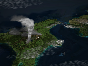
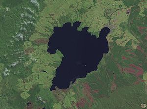
Lake Taupo
, in the centre of New Zealand
’s North Island is not recognised as such by most people, but it is actually the Caldera
of a large rhyolitic volcano. This huge volcano has produced two of the world’s most violent eruptions in geologically recent times.
The Taupo Volcano forms part of the Taupo Volcanic Zone
, a region of volcanic activity that extends from Ruapehu
in the South, through the Taupo
and Rotorua regions, to White Island
, in the Bay of Plenty
.
Taupo began erupting about 300,000 years ago, but the main eruptions that still affect the surrounding landscape are the Oruanui eruption
, about 26,500 years ago, that is responsible for the shape of the modern caldera, and the Taupo Eruption, about 1,800 years ago. However, there have been many more eruptions, with about one every thousand years or so.
, a viscous magma, with a high silica content.
If the magma does not contain much gas, rhyolite tends to just form a lava dome. However, when mixed with gas or steam, rhyolitic eruptions can be extremely violent. The magma froths to form pumice and ash, which is thrown out with great force.
If the volcano creates a stable plume, high in the atmosphere, the pumice and ash is blown sideways, and eventually falls to the ground, draping the landscape like snow.
If the material thrown out cools too rapidly, and becomes denser than the air, it cannot rise as high, and suddenly collapses back to the ground, forming a Pyroclastic Flow
, hitting the surface like water from a waterfall, and spreading sideways across the land at enormous speed. When the pumice and ash settles, it is sufficiently hot to stick together as a rock called Ignimbrite
. Pyroclastic flows can travel hundreds of kilometres an hour.
While Taupo has been active for 300,000 years, explosive eruptions became more common 65,000 years ago.
 The Oruanui eruption of the Taupo volcano was the world's largest known eruption in the past 70,000 years, with a Volcanic Explosivity Index
of 8. It occurred around 26,500 years ago and generated approximately 430 km³ of pyroclastic fall
deposits, 320 km³ of pyroclastic density current (PDC) deposits (mostly ignimbrite
) and 420 km³ of primary intracaldera material, equivalent to 530 km³ of magma
.
Modern Lake Taupo
partly fills the caldera
generated during this eruption.
Tephra
from the eruption covered much of the central North Island
with ignimbrite up to 200 metres deep. Most of New Zealand was affected by ash fall, with even an 18 cm ash layer left on the Chatham Islands
, 1,000 km away. Later erosion and sedimentation had long-lasting effects on the landscape, and caused the Waikato River
to shift from the Hauraki Plains
to its current course through the Waikato to the Tasman Sea
.
 The Taupo Eruption (also known as the Hatepe eruption) represents the latest eruption from the Taupo Volcano, and occurred about 1,800 years ago. It represents the most violent eruption in the world in the last 5,000 years.
The main pyroclastic flow devastated the surrounding area, climbing over 1500 metres (5000 ft) to overtop the nearby Kaimanawa Ranges and Mount Tongariro
, and covering the land within 80 kilometres (49.7 mi) with ignimbrite
from Rotorua
to Waiouru
. Only Ruapehu
was high enough to divert the flow.
The power of the pyroclasitc flow was so strong that in some places it eroded more material off the ground surface than it replaced with ignimbrite. Valleys were filled with ignimbrite, evening out the shape of the land.
All vegetation within the area was flattened. Loose pumice and ash deposits formed lahars down all the main rivers.
The eruption further expanded the lake
, which had formed after the much larger Oruanui eruption. The previous outlet was blocked, raising the lake 35 metres above its present level until it broke out in a huge flood, flowing for more than a week at roughly 200 times the Waikato River
's current rate.
s in Greenland
and Antarctica. It is possible that the meteorological phenomena described by Fan Ye
in China and by Herodian
in Rome were due to this eruption, which would give a date of exactly to 186 however ash from volcanic activity does not normally cross hemispheres, and recent radiocarbon dating by R. Sparks has put the date at 233 CE +/- 13 (95% confidence).
There was no local population at this time
, so the nearest humans would have been those in Australia, more than 2000 km to the west.
Lake Taupo
Lake Taupo is a lake situated in the North Island of New Zealand. With a surface area of , it is the largest lake by surface area in New Zealand, and the second largest freshwater lake by surface area in geopolitical Oceania after Lake Murray ....
, in the centre of New Zealand
New Zealand
New Zealand is an island country in the south-western Pacific Ocean comprising two main landmasses and numerous smaller islands. The country is situated some east of Australia across the Tasman Sea, and roughly south of the Pacific island nations of New Caledonia, Fiji, and Tonga...
’s North Island is not recognised as such by most people, but it is actually the Caldera
Caldera
A caldera is a cauldron-like volcanic feature usually formed by the collapse of land following a volcanic eruption, such as the one at Yellowstone National Park in the US. They are sometimes confused with volcanic craters...
of a large rhyolitic volcano. This huge volcano has produced two of the world’s most violent eruptions in geologically recent times.
The Taupo Volcano forms part of the Taupo Volcanic Zone
Taupo Volcanic Zone
The Taupo Volcanic Zone is a highly active volcanic V shaped area in the North Island of New Zealand that is spreading east -west at the rate of about 8mm per year...
, a region of volcanic activity that extends from Ruapehu
Mount Ruapehu
Mount Ruapehu, or just Ruapehu, is an active stratovolcano at the southern end of the Taupo Volcanic Zone in New Zealand. It is 23 kilometres northeast of Ohakune and 40 kilometres southwest of the southern shore of Lake Taupo, within Tongariro National Park...
in the South, through the Taupo
Taupo District
The Taupo District covers 6,350 km² of land, as well as a further 610 km² of lake area, both in Lake Taupo, New Zealand's largest lake, and also in the smaller Lake Rotoaira. The district stretches from the small town of Mangakino in the northwest to the Tongariro National Park in the...
and Rotorua regions, to White Island
Whakaari/White Island
Whakaari/White Island is an active andesite stratovolcano, situated from the east coast of the North Island of New Zealand, in the Bay of Plenty. The nearest mainland towns are Whakatane and Tauranga....
, in the Bay of Plenty
Bay of Plenty
The Bay of Plenty , often abbreviated to BOP, is a region in the North Island of New Zealand situated around the body of water of the same name...
.
Taupo began erupting about 300,000 years ago, but the main eruptions that still affect the surrounding landscape are the Oruanui eruption
Oruanui eruption
The Oruanui eruption of New Zealand's Taupo Volcano was the world's largest known eruption in the past 70,000 years, with a Volcanic Explosivity Index of 8...
, about 26,500 years ago, that is responsible for the shape of the modern caldera, and the Taupo Eruption, about 1,800 years ago. However, there have been many more eruptions, with about one every thousand years or so.
Rhyolitic Eruptions
The Taupo Volcano erupts rhyoliteRhyolite
This page is about a volcanic rock. For the ghost town see Rhyolite, Nevada, and for the satellite system, see Rhyolite/Aquacade.Rhyolite is an igneous, volcanic rock, of felsic composition . It may have any texture from glassy to aphanitic to porphyritic...
, a viscous magma, with a high silica content.
If the magma does not contain much gas, rhyolite tends to just form a lava dome. However, when mixed with gas or steam, rhyolitic eruptions can be extremely violent. The magma froths to form pumice and ash, which is thrown out with great force.
If the volcano creates a stable plume, high in the atmosphere, the pumice and ash is blown sideways, and eventually falls to the ground, draping the landscape like snow.
If the material thrown out cools too rapidly, and becomes denser than the air, it cannot rise as high, and suddenly collapses back to the ground, forming a Pyroclastic Flow
Pyroclastic flow
A pyroclastic flow is a fast-moving current of superheated gas and rock , which reaches speeds moving away from a volcano of up to 700 km/h . The flows normally hug the ground and travel downhill, or spread laterally under gravity...
, hitting the surface like water from a waterfall, and spreading sideways across the land at enormous speed. When the pumice and ash settles, it is sufficiently hot to stick together as a rock called Ignimbrite
Ignimbrite
An ignimbrite is the deposit of a pyroclastic density current, or pyroclastic flow, a hot suspension of particles and gases that flows rapidly from a volcano, driven by a greater density than the surrounding atmosphere....
. Pyroclastic flows can travel hundreds of kilometres an hour.
Earlier Eruptions
Earlier ignimbrite eruptions occurred further north than Taupo. Some of these were enormous, and two eruptions around 1.25 and 1.0 million years ago were big enough to generate an ignimbrite sheet that covered the North Island from Auckland to Napier.While Taupo has been active for 300,000 years, explosive eruptions became more common 65,000 years ago.
The Oruanui Eruption
Volcanic Explosivity Index
The Volcanic Explosivity Index was devised by Chris Newhall of the U.S. Geological Survey and Stephen Self at the University of Hawaii in 1982 to provide a relative measure of the explosiveness of volcanic eruptions....
of 8. It occurred around 26,500 years ago and generated approximately 430 km³ of pyroclastic fall
Pyroclastic fall
A pyroclastic fall is a uniform deposit of material which has been ejected from a volcanic eruption or plume such as an ash fall or tuff. Pyroclastic air fall deposits are a result of:...
deposits, 320 km³ of pyroclastic density current (PDC) deposits (mostly ignimbrite
Ignimbrite
An ignimbrite is the deposit of a pyroclastic density current, or pyroclastic flow, a hot suspension of particles and gases that flows rapidly from a volcano, driven by a greater density than the surrounding atmosphere....
) and 420 km³ of primary intracaldera material, equivalent to 530 km³ of magma
Magma
Magma is a mixture of molten rock, volatiles and solids that is found beneath the surface of the Earth, and is expected to exist on other terrestrial planets. Besides molten rock, magma may also contain suspended crystals and dissolved gas and sometimes also gas bubbles. Magma often collects in...
.
Modern Lake Taupo
Lake Taupo
Lake Taupo is a lake situated in the North Island of New Zealand. With a surface area of , it is the largest lake by surface area in New Zealand, and the second largest freshwater lake by surface area in geopolitical Oceania after Lake Murray ....
partly fills the caldera
Caldera
A caldera is a cauldron-like volcanic feature usually formed by the collapse of land following a volcanic eruption, such as the one at Yellowstone National Park in the US. They are sometimes confused with volcanic craters...
generated during this eruption.
Tephra
Tephra
200px|thumb|right|Tephra horizons in south-central [[Iceland]]. The thick and light coloured layer at center of the photo is [[rhyolitic]] tephra from [[Hekla]]....
from the eruption covered much of the central North Island
North Island
The North Island is one of the two main islands of New Zealand, separated from the much less populous South Island by Cook Strait. The island is in area, making it the world's 14th-largest island...
with ignimbrite up to 200 metres deep. Most of New Zealand was affected by ash fall, with even an 18 cm ash layer left on the Chatham Islands
Chatham Islands
The Chatham Islands are an archipelago and New Zealand territory in the Pacific Ocean consisting of about ten islands within a radius, the largest of which are Chatham Island and Pitt Island. Their name in the indigenous language, Moriori, means Misty Sun...
, 1,000 km away. Later erosion and sedimentation had long-lasting effects on the landscape, and caused the Waikato River
Waikato River
The Waikato River is the longest river in New Zealand. In the North Island, it runs for 425 kilometres from the eastern slopes of Mount Ruapehu, joining the Tongariro River system and emptying into Lake Taupo, New Zealand's largest lake. It drains Taupo at the lake's northeastern edge, creates the...
to shift from the Hauraki Plains
Hauraki Plains
The Hauraki Plains are a geographical feature and non-administrative area located in the northern North Island of New Zealand, at the lower end of the Thames Valley...
to its current course through the Waikato to the Tasman Sea
Tasman Sea
The Tasman Sea is the large body of water between Australia and New Zealand, approximately across. It extends 2,800 km from north to south. It is a south-western segment of the South Pacific Ocean. The sea was named after the Dutch explorer Abel Janszoon Tasman, the first recorded European...
.
The Taupo Eruption
Stages of Eruption
The eruption went through several stages.- A minor eruption occurred beneath the ancestral Lake Taupo.
- A dramatic increase in activity produced a high eruption column from a second vent, and pumice was deposited over a wide area.
- Water entered the first vent, and mixed with the magma, producing a white ash-rich pumice fall.
- A new vent formed, and produced a dark ash- and obsidian-rich fall deposit.
- A larger eruption ensued, producing pumice over a huge area, and a small ignimbriteIgnimbriteAn ignimbrite is the deposit of a pyroclastic density current, or pyroclastic flow, a hot suspension of particles and gases that flows rapidly from a volcano, driven by a greater density than the surrounding atmosphere....
deposit. - The most destructive part of the eruption then occurred. Part of the vent area collapsed, unleashing about 30 km³ of material, that formed a fast moving (600–900 km/h) pyroclastic flow.
- Rhyolitic lava domeLava dome|250px|thumb|right|Image of the [[rhyolitic]] lava dome of [[Chaitén Volcano]] during its 2008–2009 eruption.In volcanology, a lava dome is a roughly circular mound-shaped protrusion resulting from the slow extrusion of viscous lava from a volcano...
s were extruded some years later, forming the Horomatangi reefReefIn nautical terminology, a reef is a rock, sandbar, or other feature lying beneath the surface of the water ....
s and Waitahanui bank.
The main pyroclastic flow devastated the surrounding area, climbing over 1500 metres (5000 ft) to overtop the nearby Kaimanawa Ranges and Mount Tongariro
Mount Tongariro
Mount Tongariro is a volcanic complex in the North Island of New Zealand. It is located 20 kilometres to the southwest of Lake Taupo, and is the northernmost of the three active volcanoes that dominate the landscape of the central North Island....
, and covering the land within 80 kilometres (49.7 mi) with ignimbrite
Ignimbrite
An ignimbrite is the deposit of a pyroclastic density current, or pyroclastic flow, a hot suspension of particles and gases that flows rapidly from a volcano, driven by a greater density than the surrounding atmosphere....
from Rotorua
Rotorua
Rotorua is a city on the southern shores of the lake of the same name, in the Bay of Plenty region of the North Island of New Zealand. The city is the seat of the Rotorua District, a territorial authority encompassing the city and several other nearby towns...
to Waiouru
Waiouru
Waiouru is a small town in the centre of the North Island of New Zealand. It is on the North Island Volcanic Plateau, 25 kilometres south-east of Mount Ruapehu, and in the Ruapehu District....
. Only Ruapehu
Ruapehu
Ruapehu may refer to:* Mount Ruapehu, the highest mountain in the North Island of New Zealand* Ruapehu District, the local government area that covers much land generally west and south of Mount Ruapehu, mostly in the headwaters of the Whanganui River...
was high enough to divert the flow.
The power of the pyroclasitc flow was so strong that in some places it eroded more material off the ground surface than it replaced with ignimbrite. Valleys were filled with ignimbrite, evening out the shape of the land.
All vegetation within the area was flattened. Loose pumice and ash deposits formed lahars down all the main rivers.
The eruption further expanded the lake
Lake
A lake is a body of relatively still fresh or salt water of considerable size, localized in a basin, that is surrounded by land. Lakes are inland and not part of the ocean and therefore are distinct from lagoons, and are larger and deeper than ponds. Lakes can be contrasted with rivers or streams,...
, which had formed after the much larger Oruanui eruption. The previous outlet was blocked, raising the lake 35 metres above its present level until it broke out in a huge flood, flowing for more than a week at roughly 200 times the Waikato River
Waikato River
The Waikato River is the longest river in New Zealand. In the North Island, it runs for 425 kilometres from the eastern slopes of Mount Ruapehu, joining the Tongariro River system and emptying into Lake Taupo, New Zealand's largest lake. It drains Taupo at the lake's northeastern edge, creates the...
's current rate.
Dating the Taupo Eruption
Many dates have been given for the Taupo Eruption. One estimated date is 181 CE from ice coreIce core
An ice core is a core sample that is typically removed from an ice sheet, most commonly from the polar ice caps of Antarctica, Greenland or from high mountain glaciers elsewhere. As the ice forms from the incremental build up of annual layers of snow, lower layers are older than upper, and an ice...
s in Greenland
Greenland
Greenland is an autonomous country within the Kingdom of Denmark, located between the Arctic and Atlantic Oceans, east of the Canadian Arctic Archipelago. Though physiographically a part of the continent of North America, Greenland has been politically and culturally associated with Europe for...
and Antarctica. It is possible that the meteorological phenomena described by Fan Ye
Fan Ye (historian)
Fan Ye , courtesy name Weizong , was a Chinese historian and the compiler of Book of Later Han of Liu Song. Fan came from an official family background, he was born in present-day Shaoxing, Zhejiang, his ancestry was from Nanyang, Henan. His father was Fan Tai .-References:*Tan, Jiajian, ....
in China and by Herodian
Herodian
Herodian or Herodianus of Syria was a minor Roman civil servant who wrote a colourful history in Greek titled History of the Empire from the Death of Marcus in eight books covering the years 180 to 238. His work is not entirely reliable although his relatively unbiased account of Elagabalus is...
in Rome were due to this eruption, which would give a date of exactly to 186 however ash from volcanic activity does not normally cross hemispheres, and recent radiocarbon dating by R. Sparks has put the date at 233 CE +/- 13 (95% confidence).
There was no local population at this time
History of New Zealand
The history of New Zealand dates back at least 700 years to when it was discovered and settled by Polynesians, who developed a distinct Māori culture centred on kinship links and land. The first European explorer to discover New Zealand was Abel Janszoon Tasman on 13 December 1642...
, so the nearest humans would have been those in Australia, more than 2000 km to the west.
External links
- Lake-floor relief map, from The main eruption vents are marked by submarine peaks on the far side of Lake Taupo.