

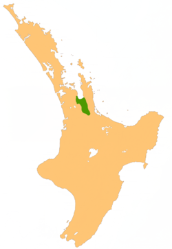
Hauraki Plains
Encyclopedia
North Island
The North Island is one of the two main islands of New Zealand, separated from the much less populous South Island by Cook Strait. The island is in area, making it the world's 14th-largest island...
of New Zealand
New Zealand
New Zealand is an island country in the south-western Pacific Ocean comprising two main landmasses and numerous smaller islands. The country is situated some east of Australia across the Tasman Sea, and roughly south of the Pacific island nations of New Caledonia, Fiji, and Tonga...
, at the lower (northern) end of the Thames Valley
Thames Valley
The Thames Valley Region is a loose term for the English counties and towns roughly following the course of the River Thames as it flows from Oxfordshire in the west to London in the east. It includes parts of Buckinghamshire, Berkshire, North Hampshire, Surrey and west London...
. They are located 75 kilometres south-east of Auckland
Auckland
The Auckland metropolitan area , in the North Island of New Zealand, is the largest and most populous urban area in the country with residents, percent of the country's population. Auckland also has the largest Polynesian population of any city in the world...
, at the foot of the Coromandel Peninsula
Coromandel Peninsula
The Coromandel Peninsula lies in the North Island of New Zealand. It is part of the Waikato Region and Thames-Coromandel District and extends 85 kilometres north from the western end of the Bay of Plenty, forming a natural barrier to protect the Hauraki Gulf and the Firth of Thames in the west...
and occupy the southern portion of a rift valley
Rift valley
A rift valley is a linear-shaped lowland between highlands or mountain ranges created by the action of a geologic rift or fault. This action is manifest as crustal extension, a spreading apart of the surface which is subsequently further deepened by the forces of erosion...
bounded on the north-west by the Hunua Ranges
Hunua Ranges
The Hunua Ranges form a block of hilly country to the southeast of Auckland in New Zealand's North Island. They cover some 250 square kilometres , containing 178 km² of parkland, and rise to 688 metres at Kohukohunui...
, to the east by the Coromandel
Coromandel Range
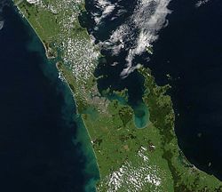
right|thumb|250px|A true-colour image showing Auckland city , the Hauraki Gulf and the Coromandel Peninsula . The scene was acquired by NASA's Terra satellite, on October 23, 2002.The Coromandel Range is a ridge of rugged hills running the length of the Coromandel Peninsula in the North Island of...
and Kaimai Ranges and the west by a series of undulating hills which separate the plains from the much larger plains of the Waikato River
Waikato River
The Waikato River is the longest river in New Zealand. In the North Island, it runs for 425 kilometres from the eastern slopes of Mount Ruapehu, joining the Tongariro River system and emptying into Lake Taupo, New Zealand's largest lake. It drains Taupo at the lake's northeastern edge, creates the...
. Broadly, the northern and southern parts of the Hauraki Plains are administered by the Hauraki District
Hauraki District
The Hauraki District Council is a municipality in the Waikato Region of New Zealand. The seat of the council is at Paeroa.The area covered by the district extends from the southwest corner of the Firth of Thames southeast towards Te Aroha, although that town lies beyond its boundaries...
and the Matamata-Piako District
Matamata-Piako District
The Matamata-Piako District is a local government area in the Waikato region of New Zealand. It lies to the east of the city of Hamilton.The district encompasses the southern end of the Hauraki Plains and much of the Thames Valley, and is bounded in the east by the Kaimai Range...
respectively.
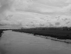
The alluvial plains have been built up by sediment deposited by the Piako
Piako River
The Piako River is a lowland river system that drains into the Firth of Thames on the North Island of New Zealand. Together with the Waihou River, it is one of the two main rivers systems which drains the Hauraki Plains...
and Waihou River
Waihou River
thumb|The Waihou River near [[Putaruru]]The Waihou River is located in the northern North Island of New Zealand. Its former name, Thames River, was bestowed by Captain James Cook....
s, which flow north to reach the sea at the Firth of Thames
Firth of Thames
The Firth of Thames is a large bay located in the north of the North Island of New Zealand. It is the firth of the rivers Waihou and Piako, the former of which was formerly named the Thames River, and the town of Thames lies on its southeastern coast....
, and earlier by the ancestral Waikato River. The resulting land is flat, peat-heavy, and partly swampy which has been converted into excellent land for dairy
Dairy
A dairy is a business enterprise established for the harvesting of animal milk—mostly from cows or goats, but also from buffalo, sheep, horses or camels —for human consumption. A dairy is typically located on a dedicated dairy farm or section of a multi-purpose farm that is concerned...
farming.
Economically, the dairy farming is the leading primary industry, supported by other grassland farming. More recently, tourism
Tourism
Tourism is travel for recreational, leisure or business purposes. The World Tourism Organization defines tourists as people "traveling to and staying in places outside their usual environment for not more than one consecutive year for leisure, business and other purposes".Tourism has become a...
in the Hauraki Plains region has been growing and part of the New Zealand Cycle Trail is being constructed in the Hauraki Plains.
The largest town fully within the Plains is Ngatea
Ngatea
Ngatea is a small town on the Hauraki Plains in the North Island of New Zealand. It is located 18 kilometres southwest of Thames and 70 kilometres southeast of Auckland. Ngatea lies on the Piako River, eight kilometres south of its outflow into the Firth of Thames.Ngatea is the 'service centre' for...
, with a smaller settlement of Turua
Turua
Turua is a small village community located on the banks of the Waihou River in the Hauraki Plains, southeast of Auckland in the North Island of New Zealand. Turua is a Maori place name meaning "twice seen," referring to reflections in the river...
. The larger town of Paeroa
Paeroa
Paeroa is a small town in New Zealand, in the northern Waikato region of the Thames Valley. Located at the foot of the Coromandel Peninsula, it is close to the junction of the Waihou and Ohinemuri Rivers, 20 kilometres from the coast at the Firth of Thames...
is located on the eastern edge of the Hauraki Plains. While there is no defined geographical southern boundary to the Hauraki Plains, this is generally taken as been a line between the towns of Te Aroha
Te Aroha
Te Aroha is a rural town in the Waikato region of New Zealand with a population of 3,768 . It is 53 km northeast of Hamilton and 50 km south of Thames. It sits at the foot of 952-metre Mount Te Aroha, the highest point in the Kaimai Range....
and Morrinsville
Morrinsville
Morrinsville is a town in the Waikato region of New Zealand's North Island. The land for the town and surrounding farmland was purchased from Wirimu Tamehana,the king maker prior to the NZ land wars of the 1860s. The land then was very swampy...
, approximately following State Highway 26.
Formation
Around 2-3 million years ago, a large block of the crust slumped down 500-2000 metres, forming the Hauraki grabenGraben
In geology, a graben is a depressed block of land bordered by parallel faults. Graben is German for ditch. Graben is used for both the singular and plural....
. The ancestral Waikato River
Waikato River
The Waikato River is the longest river in New Zealand. In the North Island, it runs for 425 kilometres from the eastern slopes of Mount Ruapehu, joining the Tongariro River system and emptying into Lake Taupo, New Zealand's largest lake. It drains Taupo at the lake's northeastern edge, creates the...
often flowed through the resulting valley into the Hauraki Gulf, most recently through the Hinuera Valley some 20,000 years ago. Over time, the Hauraki Basin slowly filled up with pumice, mud and gravel.
Wetlands
After the last shift of the Waikato River back to the west coast, the WaihouWaihou River
thumb|The Waihou River near [[Putaruru]]The Waihou River is located in the northern North Island of New Zealand. Its former name, Thames River, was bestowed by Captain James Cook....
and Piako River
Piako River
The Piako River is a lowland river system that drains into the Firth of Thames on the North Island of New Zealand. Together with the Waihou River, it is one of the two main rivers systems which drains the Hauraki Plains...
s were formed. These two rivers carried silt out into the Firth of Thames
Firth of Thames
The Firth of Thames is a large bay located in the north of the North Island of New Zealand. It is the firth of the rivers Waihou and Piako, the former of which was formerly named the Thames River, and the town of Thames lies on its southeastern coast....
or Tikapa.
The plains were full of mangroves and was a dense forest of kahikatea. Most of the land was raw peat, varying in depth from a metre to more than twenty metres. It was a morass, the home of wild ducks and eels. Nevertheless, the rich flora and fauna of the plains amply provided the staples of the Maori people who lived in the region.
The early European colonists were attracted not necessarily by the land but by the dense forest of kahikatea. The colonists, or Pakeha, were timber millers such as the George and Martha Bagnall family who settled at Turua in 1875. As the kahikatea was felled, farmers followed onto the newly cleared land. But, once a year the Waihou and Piako Rivers would overflow, making agricultural settlement of the area difficult because of the poor drainage. The people who lived around Hauraki wanted permission from the Government to drain the land but the Government said it could never be done. After all, parts of the Hauraki Plains were two meters below sea level. But the people persisted so in 1908, an act was passed to give the people permission to drain the land. The Government paid the workers to dig the drains. It was going to be a huge job that would take a good ten years.
First land ballots
In 1910 the Government decided to open an area of 16299 acres (66 km²) for settlement on the Hauraki Plains, and that ballots would be held for the blocks. This brought great interests. Not just to future settlers but also to businessmen in the Thames ValleyThames Valley, New Zealand
The Thames Valley is a non-administrative region in the North Island of New Zealand. Broadly, it is the valley component of the Waihou River catchment . The lower part of the valley is more commonly known as the Hauraki Plains. Geographically the valley extends as far as Piarere, although this is...
. Miners in the South Island
South Island
The South Island is the larger of the two major islands of New Zealand, the other being the more populous North Island. It is bordered to the north by Cook Strait, to the west by the Tasman Sea, to the south and east by the Pacific Ocean...
were saying, “If only one could draw a section one would be made.”On the 18th of May 1910 at the Miner’s Union Hall in Thames, the first applications for land blocks were made. Prices ranged from around $10-$15 an acre, depending on how much land was being bought and whether or not the block was in a good location. Some of the top spots had up to 99 applicants.
Drainage systems
Piako River
The Piako River is a lowland river system that drains into the Firth of Thames on the North Island of New Zealand. Together with the Waihou River, it is one of the two main rivers systems which drains the Hauraki Plains...
, which overflowed at least once a year, needed stop banks constructed to prevent flood and tidal overflow.
What the farmers had to do was to dig drains through their land. These would be about one to two metres wide. The drains would join onto the main drains, which brought the water out and into the canals. Floodgates were put in so water would flow out of the drains and into the canals but not back out them. Once the draining was completed over 75% of the wetlands of the Hauraki Plains was lost because of the draining.
Drainage was only the first step to making farmland. Once the land was semi-drained, it had to be turned into pasture. This meant clearing scrub, logs, tree stumps and levelling the earth. The workers usually stacked all the scrub and peat
Peat
Peat is an accumulation of partially decayed vegetation matter or histosol. Peat forms in wetland bogs, moors, muskegs, pocosins, mires, and peat swamp forests. Peat is harvested as an important source of fuel in certain parts of the world...
waste in to a big pile and burn it off.
"…But I can never forget the smell of burning peat in the hot summers. I liked it; the haze from the fires hung over everything, and the sunsets were glorious…" Mrs E. Bashum.
River transport
River transport was the best means of getting goods, people and animals to the Hauraki Plains in the early days, when the roads were non-existent or poorly maintained.Quote – “It was undoubtedly the waters of the Firth
Firth of Thames
The Firth of Thames is a large bay located in the north of the North Island of New Zealand. It is the firth of the rivers Waihou and Piako, the former of which was formerly named the Thames River, and the town of Thames lies on its southeastern coast....
, Piako
Piako River
The Piako River is a lowland river system that drains into the Firth of Thames on the North Island of New Zealand. Together with the Waihou River, it is one of the two main rivers systems which drains the Hauraki Plains...
and Waihou
Waihou River
thumb|The Waihou River near [[Putaruru]]The Waihou River is located in the northern North Island of New Zealand. Its former name, Thames River, was bestowed by Captain James Cook....
that gave access to the plains for human enterprise and settlement for both Māori and Pakeha” – Ruffus Tye (Hauraki Plains Story).
Ship traffic
Ships of all sizes plied the rivers of the Hauraki Plains, from tiny row boats to huge barques although, most of the boats were steamers and the engines were made at A & G Price in Thames.As industries progressed (like the mining in Waihi) bigger ships were required to carry the bigger loads. The majority of the boats were steamers, but some were paddle steamers. Larger passenger ships had luxurious lounges for men and women decorated with velvet upholstery and paintings on the walls. There were even brass bands on some boats and room for dancing on the decks. There was also room for horses and general cargo. Some cargo boats and punts were designed with drop sides to assist in loading and unloading on the river banks. This was especially useful when animals were being loaded.
During the mining strike the hotels were closed by the government but you could still drink on a moving boat. So people would get on the boats and take a trip for the day just to use the bar.
In 1877 massive timber ships called barque
Barque
A barque, barc, or bark is a type of sailing vessel with three or more masts.- History of the term :The word barque appears to have come from the Greek word baris, a term for an Egyptian boat. This entered Latin as barca, which gave rise to the Italian barca, Spanish barco, and the French barge and...
s traveled up to Bagnalls’ mill in Turua to collect the kahikatea logs and transport them to Auckland and Australia. You can still see the remains of the wharf where the ships berthed. When the Bagnalls first arrived in Turua and wanted to go to church in Thames, they rowed to Kopu then walked the last five miles (8 km) to Thames.
At Orchard (now called Ngatea
Ngatea
Ngatea is a small town on the Hauraki Plains in the North Island of New Zealand. It is located 18 kilometres southwest of Thames and 70 kilometres southeast of Auckland. Ngatea lies on the Piako River, eight kilometres south of its outflow into the Firth of Thames.Ngatea is the 'service centre' for...
), Pipiroa, Kopu and Paeroa there were punts (floating platforms) that carried people, horses and carts across the rivers for a small fee. At Te Aroha, there was a wire rope stretched across the river which originally had a Māori canoe tied to it on which people could pull themselves across and was later replaced by a punt with a crank and for two shillings people could crank themselves across.
River systems
Geologists have shown that a very long time ago the Waikato river came through the Hinurea valley and filled the Hauraki Basin with pumice, mud, drift wood and gravel to a depth of over 1200 ft. You can still see evidence of sea beaches between Shelly Beach and Maukoro.Before the arrival of the European
European ethnic groups
The ethnic groups in Europe are the various ethnic groups that reside in the nations of Europe. European ethnology is the field of anthropology focusing on Europe....
settlers the Hauraki Plains was 400 km² of peat and swamp land which acted as a big ponding area, through which ran two main rivers - the Waihou and Piako
Piako River
The Piako River is a lowland river system that drains into the Firth of Thames on the North Island of New Zealand. Together with the Waihou River, it is one of the two main rivers systems which drains the Hauraki Plains...
.
Māori used the rivers for hundreds of years to get to the rich food resources in the swamp. When the Europeans came they also used the rivers for transport. Because the Hauraki Plains were swamp land and there were no roads the easiest way to transport people, supplies, food and produce was by boat.
Gold brought many ships up the Waihou and Ohinimuri rivers with heavy machinery and miners aboard. There was even a special hard wharf built at Paeroa for fear of a conventional one collapsing while the machines were unloaded.
Bagnells’ mill at Turua was established to mill the tall kahikatea trees growing there. Huge barques (sailing ships) came up the river on flood tides to collect the wood, some of which would be taken to Australia and be made in to butter boxes.
After the scrub and kahikatea had been cleared farming was taken up and the farmers needed everything from food to animals and boats and the rivers carried it all in.
In pioneer days the rivers were the lifelines of the Hauraki Plains, but as roads improved and bridges were built the need for river transport diminished. Today it has all died away except the ferry that goes up the Waihou to Paeroa from Auckland, and the metal barge that comes into Kopu to pick up a load.
Waihou River
In 1769 Captain James Cook travelled up the Waihou RiverWaihou River
thumb|The Waihou River near [[Putaruru]]The Waihou River is located in the northern North Island of New Zealand. Its former name, Thames River, was bestowed by Captain James Cook....
to look at the “lofty trees which adorn its banks”. He was the first European to travel up the river. The Waihou reminded him of the River Thames
River Thames
The River Thames flows through southern England. It is the longest river entirely in England and the second longest in the United Kingdom. While it is best known because its lower reaches flow through central London, the river flows alongside several other towns and cities, including Oxford,...
in London so he named it the River Thames. Although this name stuck for quite some time, now it is known as the Waihou. His discovery of the kahikatea tree later brought many ships to the area looking for masts and spars.
In the 1900s the Waihou was navigable right up to Matamata
Matamata
Matamata is a rural Waikato town in New Zealand with a population of around 12,000 . It is located near the base of the Kaimai Ranges, and is a thriving farming area known for Thoroughbred horse breeding and training pursuits...
, because development had not yet silted up the river. Travelling up stream you would pass Kopu on the left then Turua
Turua
Turua is a small village community located on the banks of the Waihou River in the Hauraki Plains, southeast of Auckland in the North Island of New Zealand. Turua is a Maori place name meaning "twice seen," referring to reflections in the river...
on the right, Matatoki
Matatoki
Matatoki is a locality on the Hauraki Plains of New Zealand. It lies on State Highway 26, south east of Thames and north of Paeroa. The Matatoki Stream runs from the Coromandel Range through the area to join the Waihou River....
, Puriri
Puriri, New Zealand
Puriri is a small locality on the Hauraki Plains of New Zealand. It lies approximately 14km south-east of Thames, New Zealand.Puriri was originally a Ngati Maru settlement, which the Rev. Henry Williams and three fellow missionaries visited in October 1833. They subsequently established a mission...
, Hikutaia
Hikutaia
Hikutaia is a locality on the Hauraki Plains of New Zealand. It lies on State Highway 26, south east of Thames and north of Paeroa. The Hikutaia River runs from the Coromandel Range through the area to join the Waihou River.-History:...
, Paeroa
Paeroa
Paeroa is a small town in New Zealand, in the northern Waikato region of the Thames Valley. Located at the foot of the Coromandel Peninsula, it is close to the junction of the Waihou and Ohinemuri Rivers, 20 kilometres from the coast at the Firth of Thames...
and Te Aroha
Te Aroha
Te Aroha is a rural town in the Waikato region of New Zealand with a population of 3,768 . It is 53 km northeast of Hamilton and 50 km south of Thames. It sits at the foot of 952-metre Mount Te Aroha, the highest point in the Kaimai Range....
on the left and eventually Matamata on the right.
Piako River
The Piako RiverPiako River
The Piako River is a lowland river system that drains into the Firth of Thames on the North Island of New Zealand. Together with the Waihou River, it is one of the two main rivers systems which drains the Hauraki Plains...
is much smaller than the Waihou, but it was just as important in the development of the Hauraki Plains. Travelling up the Piako you would see Pipiroa, then Ngatea, both on the right, followed by Kerepehi, and the last town accessible by boat was Patetonga.
Supplies were brought up the Piako by a small yacht and later by a launch. The boat was the main outlet to civilization for the settlers who were mostly male bachelors and it was easier for them to eat stale bread brought up by the boat weekly than to make it themselves. It also brought mail and took cream back to Kopu which took four hours.
The rivers were a major lifeline for the Plains in the early days and they are still a part of everyday life, though not nearly as much as they used to be.
Dairy farming
Dairy farmingDairy farming
Dairy farming is a class of agricultural, or an animal husbandry, enterprise, for long-term production of milk, usually from dairy cows but also from goats and sheep, which may be either processed on-site or transported to a dairy factory for processing and eventual retail sale.Most dairy farms...
is the most important industry on the Hauraki plains, providing the most income for the region.The sizes of dairy farms range from around 100 cows to over 500. 66% of the total land area of the plains is used in dairy farming. This equates to 779.34 km² of land.
Other farming
Although dairy farming is the main industry it is not the only farming industry. Sheep and dry stock farming are beginning to catch on with farmers. There is still the demand for wool and meat, which the Hauraki Plains region helps to provide. An ostrich farm has been developed near TuruaTurua
Turua is a small village community located on the banks of the Waihou River in the Hauraki Plains, southeast of Auckland in the North Island of New Zealand. Turua is a Maori place name meaning "twice seen," referring to reflections in the river...
which deals in tourism
Tourism
Tourism is travel for recreational, leisure or business purposes. The World Tourism Organization defines tourists as people "traveling to and staying in places outside their usual environment for not more than one consecutive year for leisure, business and other purposes".Tourism has become a...
, meat sales and gifts.
Education
Hauraki Plains College is a co-ed school, situated in the end of Kaihere Road. It has approximately 650 students. Hauraki Plains College offers a junior diploma of learning for year 9 and 10 students. A wide range of extra curricular activities are available for students at all levels. In 1912, the school was first opened and called Ngatea Orchard School. It only had 15 students. Later on in 1923, the name was changed to Ngatea District High School. Finally in 1963, the name was once again changed to Hauraki Plains College.Wetlands conservation
In the 1840s an estimated 1100 km² of wetland covered the lower Waikato area and Hauraki Plains. Since then 85 to 90% of New Zealand wetlands have been lost. The Department of Conservation (DOC) estimates of wetlands that remain in the WaikatoWaikato
The Waikato Region is a local government region of the upper North Island of New Zealand. It covers the Waikato, Hauraki, Coromandel Peninsula, the northern King Country, much of the Taupo District, and parts of Rotorua District...
are around 320 km², which is 25% of what we had. This figure includes Whangamarino (5,130.35 hectares), and Kopuatai Peat Dome (9,238.44 hectares). Roughly 80% of New Zealand’s remaining wetlands are in areas across the Waikato Region, mostly within the Waikato
Waikato District
Waikato District is a territorial authority of New Zealand, in the northern part of Waikato Region, North Island. Waikato District is administered by the Waikato District Council, with headquarters in Ngaruawahia....
, Matamata-Piako
Matamata-Piako District
The Matamata-Piako District is a local government area in the Waikato region of New Zealand. It lies to the east of the city of Hamilton.The district encompasses the southern end of the Hauraki Plains and much of the Thames Valley, and is bounded in the east by the Kaimai Range...
and Hauraki
Hauraki District
The Hauraki District Council is a municipality in the Waikato Region of New Zealand. The seat of the council is at Paeroa.The area covered by the district extends from the southwest corner of the Firth of Thames southeast towards Te Aroha, although that town lies beyond its boundaries...
Districts. Five of New Zealand’s wetlands are listed on the International Convention on Wetlands of International Importance (Ramsar sites); there are three of them in the Waikato Region:
- Kopuatai Peat Dome
- Whangamarino WetlandWhangamarino RiverThe Whangamarino River is a lowland river of the Waikato Region of New Zealand's North Island, draining the Whangamarino Wetland and associated farmland catchment. The river converges with the Waikato River just north of Meremere...
- Firth of ThamesFirth of ThamesThe Firth of Thames is a large bay located in the north of the North Island of New Zealand. It is the firth of the rivers Waihou and Piako, the former of which was formerly named the Thames River, and the town of Thames lies on its southeastern coast....
estuary
Kopuatai Peat Dome
At 9,238.44 hectares, the Kopuatai Peat Dome is New Zealand’s largest unaltered restiad peat bog, and is also globally unique. The area is protected by the Wetland Management Reserve under the Conservation Act 1987 and is managed by the Department of Conservation.Fifty four species of birds have been recorded in the Kopuatai Peat Dome. Twenty seven are protected, 17 are unprotected and 10 are game birds. The endangered Australasian Bittern (Botaurus poiciloptilus) is found in the wetland with other endangered birds such as the Banded Rail (Rallus philipensis assimillis), Marsh Crake (Porzana pusilla affinis) and the North Island Fernbird (Bowdleria punctata vealeae).
Further reading
- Tye, RE, Hauraki Plains Story, Thames Valley News Ltd, Paeroa, 1974
- MacDonald, E, Western Hauraki Plains – It’s History, photocopy of handwritten book held by Hauraki Plains Library
- Sullivan, Captain William, “Kotuku” Log Book, handwritten, 1877
- Hatvany, M, "Environmental Failure, Success and Sustainable Development: The Hauraki Plains Wetlands Through Four Generations of New Zealanders," Environment and History, 14 (2008): 469-95.
- Historical Maritime Park, Paeroa
External links
- The Gulf and Its Catchment, Auckland Regional Council.