

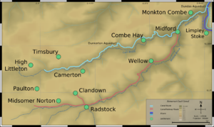
Somerset Coal Canal
Encyclopedia
England
England is a country that is part of the United Kingdom. It shares land borders with Scotland to the north and Wales to the west; the Irish Sea is to the north west, the Celtic Sea to the south west, with the North Sea to the east and the English Channel to the south separating it from continental...
, built around 1800 from basins at Paulton
Paulton
Paulton is a large village and civil parish, with a population of 4,896, located to the north of the Mendip Hills, in the unitary authority of Bath and North East Somerset , England....
and Timsbury
Timsbury, Somerset
Timsbury is a village and civil parish in the Bath and North East Somerset unitary authority of the county of Somerset, south-west of Bath England...
via Camerton
Camerton, Somerset
Camerton is a village and civil parish in Somerset, south west of Bath, lying on the Cam Brook. The parish has a population of 660.-History:...
, an aqueduct
Aqueduct
An aqueduct is a water supply or navigable channel constructed to convey water. In modern engineering, the term is used for any system of pipes, ditches, canals, tunnels, and other structures used for this purpose....
at Dunkerton
Dunkerton, Somerset
Dunkerton is a small village and civil parish north east of Radstock, and south west of Bath, in the Bath and North East Somerset unitary authority, Somerset, England. The parish has a population of 479.-History:...
, Combe Hay
Combe Hay
Combe Hay is a village and civil parish in the English county of Somerset. It falls within the Cotswolds Area of Outstanding Natural Beauty. The parish has a population of 149.-History:Combe Hay was known in the Domesday Book as Cumb...
, Midford
Midford
Midford is a village approximately miles south south east of Bath, Somerset, England within the Cotswold Area of Outstanding Natural Beauty...
and Monkton Combe
Monkton Combe
Monkton Combe is a village and civil parish in north Somerset, England, south of Bath. The parish, which includes the hamlet of Tucking Mill, has a population of 356.-History:Monkton Combe was part of the hundred of Bath Forum.According to Rev...
to Limpley Stoke
Limpley Stoke
Limpley Stoke is a village and civil parish in Wiltshire, in the Avon Valley, between Bath and Freshford. The village is below the A36 road.The civil parish, which had a population of 637 in 2001, also includes the hamlet of Waterhouse, and the outskirts of the Somerset village of Midford. The 18th...
where it joined the Kennet and Avon Canal
Kennet and Avon Canal
The Kennet and Avon Canal is a waterway in southern England with an overall length of , made up of two lengths of navigable river linked by a canal. The name is commonly used to refer to the entire length of the navigation rather than solely to the central canal section...
. This gave access from the Somerset coalfield
Somerset coalfield
The Somerset Coalfield included pits in the North Somerset, England, area where coal was mined from the 15th century until 1973.It is part of a wider coalfield which covered northern Somerset and southern Gloucestershire. It stretched from Cromhall in the north to the Mendip Hills in the south, and...
, which at its peak contained 80 collieries, to London
London
London is the capital city of :England and the :United Kingdom, the largest metropolitan area in the United Kingdom, and the largest urban zone in the European Union by most measures. Located on the River Thames, London has been a major settlement for two millennia, its history going back to its...
. The longest arm was 18 miles (29 km) long with 23 locks. From Midford an arm also ran via Writhlington
Writhlington
Writhlington is a suburb of Radstock and north-west of Frome in the Bath and North East Somerset district of Somerset, England.Andy Robinson taught Mathematics, Physical Education and Rugby at Writhlington School....
to Radstock
Radstock
Radstock is a town in Somerset, England, south west of Bath, and north west of Frome. It is within the unitary authority of Bath and North East Somerset and had a population of 5,275 according to the 2001 Census...
, with a tunnel
Tunnel
A tunnel is an underground passageway, completely enclosed except for openings for egress, commonly at each end.A tunnel may be for foot or vehicular road traffic, for rail traffic, or for a canal. Some tunnels are aqueducts to supply water for consumption or for hydroelectric stations or are sewers...
at Wellow
Wellow, Somerset
Wellow is a village and civil parish in Somerset, England, about south of Bath. The parish, which includes the hamlet of Twinhoe has a population of 511...
.
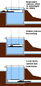
A feature of the canal was the variety of methods used at Combe Hay to overcome height differences between the upper and lower reaches of the canal, initially by the use of caisson lock
Caisson lock
A caisson lock is a type of canal lock in which a narrowboat is enclosed in a sealed box and raised or lowered between two water levels. It was intended primarily as a water-saving measure, but also to save construction costs when compared with other engineering solutions. It was capable of...
s and when this failed an inclined plane and then a flight of 22 locks.
The Radstock arm was never commercially successful and was replaced first with a tramway
Rail transport
Rail transport is a means of conveyance of passengers and goods by way of wheeled vehicles running on rail tracks. In contrast to road transport, where vehicles merely run on a prepared surface, rail vehicles are also directionally guided by the tracks they run on...
in 1815 and later incorporated into the Somerset and Dorset Joint Railway
Somerset and Dorset Joint Railway
The Somerset & Dorset Joint Railway – almost always referred to as "the S&D" – was an English railway line connecting Bath in north east Somerset and Bournemouth now in south east Dorset but then in Hampshire...
. The Paulton route flourished for some years until the coming of the railway and closed in 1898. Much of the course of the canal has since been used for a railway. In October 2006 a grant was obtained from the Heritage Lottery Fund
Heritage Lottery Fund
The Heritage Lottery Fund is a fund established in the United Kingdom under the National Lottery etc. Act 1993. The Fund opened for applications in 1994. It uses money raised through the National Lottery to transform and sustain the UK’s heritage...
to carry out a technical study on one of the locks and associated structures at Combe Hay.
History
Radstock
Radstock is a town in Somerset, England, south west of Bath, and north west of Frome. It is within the unitary authority of Bath and North East Somerset and had a population of 5,275 according to the 2001 Census...
and mining began in the area, however transport was a major problem because of the poor state of the roads. This cost and the potential for cheaper delivery of coal from south Wales
Wales
Wales is a country that is part of the United Kingdom and the island of Great Britain, bordered by England to its east and the Atlantic Ocean and Irish Sea to its west. It has a population of three million, and a total area of 20,779 km²...
via the Monmouthshire Canal led to the proposal for a canal which could transport the coal to Bath and Wiltshire
Wiltshire
Wiltshire is a ceremonial county in South West England. It is landlocked and borders the counties of Dorset, Somerset, Hampshire, Gloucestershire, Oxfordshire and Berkshire. It contains the unitary authority of Swindon and covers...
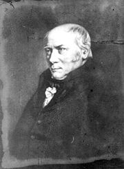
. Initial surveys were conducted during 1793 by William Jessop
William Jessop
William Jessop was an English civil engineer, best known for his work on canals, harbours and early railways in the late 18th and early 19th centuries.-Early life:...
and William Smith
William Smith (geologist)
William 'Strata' Smith was an English geologist, credited with creating the first nationwide geological map. He is known as the "Father of English Geology" for collating the geological history of England and Wales into a single record, although recognition was very slow in coming...
under the direction of John Rennie
John Rennie (father)
John Rennie was a Scottish civil engineer who designed many bridges, canals, and docks.-Early years:Rennie, a farmer's younger son, was born at Phantassie, near East Linton, East Lothian, Scotland, and showed a taste for mechanics at a very early age, and was allowed to spend much time in the...
who presented the report on 14 October 1793 estimating the cost of construction of the canal at £80,000. Smith, who also worked at the Mearns Pit at High Littleton
High Littleton
The village of High Littleton and its hamlets of Hallatrow and Amesbury form a civil parish and are located in the county of Somerset and straddle both the A39 and A37, from Bath, from Wells and from Bristol. The parish has a population of 2,086...
, made the original observations leading to his important stratification theory
Stratum
In geology and related fields, a stratum is a layer of sedimentary rock or soil with internally consistent characteristics that distinguish it from other layers...
by observing the dips
Strike and dip
Strike and dip refer to the orientation or attitude of a geologic feature. The strike line of a bed, fault, or other planar feature is a line representing the intersection of that feature with a horizontal plane. On a geologic map, this is represented with a short straight line segment oriented...
in the geological strata
Stratum
In geology and related fields, a stratum is a layer of sedimentary rock or soil with internally consistent characteristics that distinguish it from other layers...
through which the canal was cut. Smith became Surveyor to the company, but was dismissed in April 1799, apparently because he had used his position as surveyor to buy a local house at advantageous terms. He then set himself up in a private practice in Bath but was re-engaged by the company in 1811, to provide advice when repairs became necessary to the canal bed.
The canal was authorised by an Act of Parliament
Act of Parliament
An Act of Parliament is a statute enacted as primary legislation by a national or sub-national parliament. In the Republic of Ireland the term Act of the Oireachtas is used, and in the United States the term Act of Congress is used.In Commonwealth countries, the term is used both in a narrow...
entitled "An Act for making and maintaining a navigable Canal, with certain Railways and Stone Roads, from several Collieries in the county of Somerset, to communicate with the intended Kennet and Avon Canal, in the parish of Bradford, in the county of Wilts
Bradford on Avon
Bradford on Avon is a town in west Wiltshire, England with a population of about 9,326. The town's canal, historic buildings, shops, pubs and restaurants make it popular with tourists....
" of 1794, and further detailed surveys were carried out by Robert Whitworth and John Sutcliffe, who was then appointed as chief engineer.
In May 1795 tenders were invited for the first section to be built from the meadows near Goosehard (or Gooseyard) near Paulton to Hopyard in the Parish of Camerton. In June 1795 a contractor, (Houghton & Son from Shropshire), started the terminus at Paulton meadows using local labour. This first section of canal was completed on Monday the 1st of October 1798, the first load of coal along the canal was delivered to Bath via Dunkerton. Some 14 collieries at Timsbury & Paulton were connected to the Timsbury basin and Paulton meadow terminus by tramways. This involved the construction of three tramway bridges over the Cam brook. A further bridge at Dunford was required for the Canal, at this point tramways connected the Withy Mills and Radford workings. The course of the Cam brook was modified at various places to protect the canal from erosion. In 1799 William Whitmore and his partner, Norton, offered to build a balance (or geometrical) lift without payment, on condition that if successful they were to have £17,300 and a royalty of 4 pence per ton of goods passed.
The design of the caisson lock was not a success, on the 15th February 1798 the first descent failed. Mr. Weldon (the inventor), made one successful descent on the 7th June and said "I will undertake to pass 1,500 tons of goods through the lock in 12 hrs". Tenders were invited on the 28th June for further constructions. Two more attempts to use the caisson lock took place on the 11th April & the 2nd of May (only the latter was successful). By the 22nd August 1799 the second rebuilding of the caisson had been abandoned. It was replaced by three locks and an inclined plane, but the plane was not successful either, and the company proposed to raise more money to finance the building of a flight of 19 locks to replace it, the use of which would incur an additional toll of one shilling per ton on all traffic. This was vigorously opposed by the owners of the Kennet and Avon Canal
Kennet and Avon Canal
The Kennet and Avon Canal is a waterway in southern England with an overall length of , made up of two lengths of navigable river linked by a canal. The name is commonly used to refer to the entire length of the navigation rather than solely to the central canal section...
and the Wilts and Berks Canal
Wilts and Berks Canal
The Wilts & Berks Canal is a canal in the historic counties of Wiltshire and Berkshire, England, linking the Kennet and Avon Canal at Semington, near Melksham, to the River Thames at Abingdon. The North Wilts Canal merged with it to become a branch to the Thames and Severn Canal at Latton near...
, on the grounds that the price of coal to their customers would be too high. After negotiation, the company obtained a new Act of Parliament on 30 April 1802, which authorized the formation of a separate body called "The Lock Fund of the Somerset Coal Canal Company", with powers to raise the sum of £45,000. The money was raised by the Kennet and Avon, the Wilts and Berks and the Somerset Coal Canal each contributing £15,000, and the one shilling surcharge was to be levied until the capital had been repaid, after which it would cease. The act set the tonnage rates to be charged:
| Cargo | Rate |
|---|---|
| For all Coal, Coke, &c | 2½d per Ton, per Mile. |
| For all Iron, Lead, Ores, Cinders, &c | 4d ditto. ditto. |
| For all Stones, Tiles, Bricks, Slate, Timber, &c | 3d ditto. ditto. |
| For all Cattle, Sheep, Swine and other Beasts | 4d ditto. ditto. |
| For all other Goods | 4d ditto. ditto. |
| For every Horse or Ass Travelling on the Railway | 1d each. |
| For every Cow or other Neat Cattle ditto | ½d ditto. ditto. |
| For Sheep, Swine and Calves ditto | 5d per Score. |
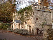
Fractions of a Mile to pay for Half a Mile, and of a Ton as a Quarter of a Ton; Rates for Wharfage to be determined by the Company. In addition to the above Rates, One Shilling per Ton is paid on all Goods to the Lock Fund, which also receives Three Farthings per Ton from the Coal Canal company. The boats were weighed at Midford where a Weigh house was constructed in 1831. The boats would be floated into a one-ended lock, the gate closed and the water drained. This left the boat resting on a cradle suspended by angled rods attached to a beam which took the weight of the boat. One-pound weights were then added to a pan with one pound being equivalent to one hundredweight
Hundredweight
The hundredweight or centum weight is a unit of mass defined in terms of the pound . The definition used in Britain differs from that used in North America. The two are distinguished by the terms long hundredweight and short hundredweight:* The long hundredweight is defined as 112 lb, which...
until the system was in equilibrium and the weight was recorded. The weigh house at Midford was one of only four known to have been built in England and Wales.
The canal opened in 1805 and was used for passenger traffic as well as coal. In 1814 the Benedictine
Benedictine
Benedictine refers to the spirituality and consecrated life in accordance with the Rule of St Benedict, written by Benedict of Nursia in the sixth century for the cenobitic communities he founded in central Italy. The most notable of these is Monte Cassino, the first monastery founded by Benedict...
monks who came to Downside Abbey
Downside Abbey
The Basilica of St Gregory the Great at Downside, commonly known as Downside Abbey, is a Roman Catholic Benedictine monastery and the Senior House of the English Benedictine Congregation. One of its main apostolates is a school for children aged nine to eighteen...
are said to have used the canal for the last stage of their journey. Another cargo carried by the canal was limestone from Combe Down
Combe Down
Combe Down is a village suburb of Bath, England in the Bath and North East Somerset unitary authority within the ceremonial county of Somerset. Combe Down sits on a ridge above and about 1.5 miles to the south of Bath city centre. "Combe" or "coombe" is a West Country word meaning a steep-sided...
. The peak level of cargo carried was in 1838 at 138,403 tons resulting in over £17,000 of tolls being paid. Cargoes of over 100,000 tons were common until the 1870s when competition from railways reduced the amount carried. The canal went into liquidation in 1893; it closed in 1898 and was finally abandoned in 1904 when it was sold to the Great Western Railway for £2,000, and used as a branch of the Bristol and North Somerset Railway. The closure caused problems across the Somerset coalfield especially to the pits in the northern area, which had relied on the canal for transportation.
The Radstock branch
When the Radstock branch was constructed, it was intended to link it to the main line of the Paulton branch at Midford, which was at a lower level at this point. The Lock Fund created in 1802 was to have paid for the construction of the locks, but because there was little regular traffic on the branch, the company built one lock, an aqueduct over the Midford Brook, and a short tramway to bridge the gap. This contributed to the economic failure of the branch, and its replacement by a tramway in 1815. The tramway was laid along the former canal's towpath. It was single-line with passing places every 600 yards (549 m), and was originally laid using cast iron plates on stone block sleepers, but was relaid using wrought iron plates.Engineers and surveyors
.jpg)
- William BennetWilliam Bennet (engineer)William Bennet was an English civil engineer, noted for his work on canals. Nothing is known of his early life or family history, but details of his work from about 1790 until 1826 are documented...
(d. 1826) - John Hodgkinson
- Benjamin OutramBenjamin OutramBenjamin Outram was an English civil engineer, surveyor and industrialist. He was a pioneer in the building of canals and tramways.-Personal life:...
(1764–1805) - John RennieJohn Rennie (father)John Rennie was a Scottish civil engineer who designed many bridges, canals, and docks.-Early years:Rennie, a farmer's younger son, was born at Phantassie, near East Linton, East Lothian, Scotland, and showed a taste for mechanics at a very early age, and was allowed to spend much time in the...
(1761–1821) - William SmithWilliam Smith (geologist)William 'Strata' Smith was an English geologist, credited with creating the first nationwide geological map. He is known as the "Father of English Geology" for collating the geological history of England and Wales into a single record, although recognition was very slow in coming...
(1769–1839) - John Sutcliffe
- Robert Weldon (?1754–1810)
- Robert Whitworth (d. 1799)
Data from Jim Shead's Waterways Information.
Combe Hay
Cam Brook, Somerset
The Cam brook is a small river in Somerset, England.It rises near Hinton Blewitt, flows through Cameley, Temple Cloud, Camerton, Dunkerton and Combe Hay...
was an inadequate source of water above Camerton, and the mills along it had water rights. Each narrow boat travelling through the series of locks (22 of them each 6 ft (1.8 m) deep) with a 25-ton load of coal caused 85 tons of water to be discharged into the brook below the locks. As a result the canal was designed with all 22 locks in one flight near Combe Hay and a pumping engine to raise water from the Cam – the first canal to entirely depend on pumping. A potential solution to the water supply problem was the use of Caisson Locks as proposed by Robert Weldon, three of which could replace the 22 conventional locks, because it wasted no water, however the technology had only been tried in a one-third scale prototype. Each lock was 80 ft (24.4 m) long and 60 ft (18.3 m) deep and contained a closed wooden box which could take a barge. This box moved up and down in the 60 ft (18 m) deep pool of water, which never left the lock. The box was demonstrated to the Prince Regent
Prince Regent
A prince regent is a prince who rules a monarchy as regent instead of a monarch, e.g., due to the Sovereign's incapacity or absence ....
(later George IV
George IV of the United Kingdom
George IV was the King of the United Kingdom of Great Britain and Ireland and also of Hanover from the death of his father, George III, on 29 January 1820 until his own death ten years later...
), but had engineering problems and was never successful commercially or built elsewhere.
It was temporarily replaced with an inclined plane
Canal inclined plane
An inclined plane is a system used on some canals for raising boats between different water levels. Boats may be conveyed afloat, in caissons, or may be carried in cradles or slings. It can be considered as a specialised type of cable railway....
by Benjamin Outram
Benjamin Outram
Benjamin Outram was an English civil engineer, surveyor and industrialist. He was a pioneer in the building of canals and tramways.-Personal life:...
who had successfully installed inclined planes at the Peak Forest Canal
Peak Forest Canal
The Peak Forest Canal, is a narrow locked artificial waterway in northern England. It is long and forms part of the connected English/Welsh inland waterway network.-General description:...
in Derbyshire
Derbyshire
Derbyshire is a county in the East Midlands of England. A substantial portion of the Peak District National Park lies within Derbyshire. The northern part of Derbyshire overlaps with the Pennines, a famous chain of hills and mountains. The county contains within its boundary of approx...
, whilst 22 locks and a Boulton & Watt Steam Pumping Station, capable of lifting 5,000 tons of water in 12 hours, were built to the latest design with metal plate clad wooden gates.
Construction. The two images show a recently uncovered (2009–10) Spillway / Drain (c1796) at Upper Midford, a location where a Caisson to take the canal from the 180 ft level to the 134 ft level at Midford Aqueduct was proposed.
Each Caisson would have had such a drain for maintenance purposes over the exit arch made to the same dimensions. The following extract from The Bath Herald Paper provides the details of the chosen sites.
"14 Jun 1798 Travel: Somerset coal canal - caisson cisterns to be formed at Combe Hay & nr. Midford. Sealed proposals reqd. on embanking & excavation with the masonry; or each separately - send to sub-committee, Waldegrave Arms, Radstock 20 Jul. Plans & specs. on appl."
For further Newspaper articles see here:- s:Bath Georgian Newspaper - Somerset Coal Canal
Paulton basin
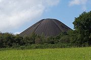
Paulton
Paulton is a large village and civil parish, with a population of 4,896, located to the north of the Mendip Hills, in the unitary authority of Bath and North East Somerset , England....
was the terminus of the northern branch of the Somerset Coal Canal and was a central point for at least 15 collieries around Paulton, Timsbury
Timsbury, Somerset
Timsbury is a village and civil parish in the Bath and North East Somerset unitary authority of the county of Somerset, south-west of Bath England...
and High Littleton
High Littleton
The village of High Littleton and its hamlets of Hallatrow and Amesbury form a civil parish and are located in the county of Somerset and straddle both the A39 and A37, from Bath, from Wells and from Bristol. The parish has a population of 2,086...
, which were connected to the canal by tramroads.
On the northern side of Paulton basin was the terminus for the tramroad which served Old Grove, Prior's, Tyning and Hayeswood pits, with a branch line to Amesbury and Mearns pits. Parts of this line were still in use in 1873, probably all carrying horse drawn wagons of coal. The southern side of the basin served Brittens, Littleborrok, Paulton Ham, Paulton Hill, Simons Hill terminating at Salisbury Colliery. In addition the Paulton Foundry used this line. The entire line was disused by 1871 as were the collieries it served.
The area has been designated as an ‘area of special architectural or historic interest, the character or appearance of which it
is desirable to preserve or enhance’ under section 69 of the Planning (Listed Buildings and Conservation Areas) Act 1990
Planning (Listed Buildings and Conservation Areas) Act 1990
The Planning Act 1990 is an Act of Parliament of the United Kingdom that altered the laws on granting of planning permission for building works, notably including those of the listed building system in England and Wales....
.
Coming of the railway
Bristol and North Somerset Railway
The Bristol and North Somerset Railway was a railway line in the West of England that connected Bristol with towns in the Somerset coalfield. The line ran almost due south from Bristol and was 16 miles long.-The main railway:...
's Frome to Radstock line completed in 1854 which took traffic away from the tramway. It finally closed in 1874 with the Somerset and Dorset Railway's extension to Bath , built along its route from Radstock to Midford. Another branch line was constructed in 1882 from Hallatrow to Camerton, running alongside the canal for the last 1.5 miles (2 km) of its route. The Great Western Railway
Great Western Railway
The Great Western Railway was a British railway company that linked London with the south-west and west of England and most of Wales. It was founded in 1833, received its enabling Act of Parliament in 1835 and ran its first trains in 1838...
built a railway line (the Bristol and North Somerset Railway
Bristol and North Somerset Railway
The Bristol and North Somerset Railway was a railway line in the West of England that connected Bristol with towns in the Somerset coalfield. The line ran almost due south from Bristol and was 16 miles long.-The main railway:...
) over much of the canal route from Limpley Stoke to Camerton, where it joined the existing 1882 branch line from Hallatrow to Camerton. This opened in 1910 for passenger and goods traffic, closed for the First World War, reopened after the war but ran for passengers only for two more years in the mid-1920s and finally closed to all traffic in the 1950s. The line was used in the 1950s Ealing comedy film The Titfield Thunderbolt
The Titfield Thunderbolt
The Titfield Thunderbolt is a 1953 British comedy film about a group of villagers trying to prevent British Railways from closing the fictional Titfield branch line. The film was written by T.E.B...
.
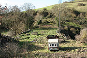
Today
The route of the canal lies in a largely agricultural area dotted with small villages and minor roads.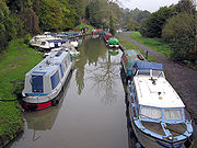
Dundas Aqueduct
Dundas Aqueduct carries the Kennet and Avon Canal over the River Avon and the Wessex Main Line railway from Bath to Westbury, near Limpley Stoke in Wiltshire, England....
was restored during the 1980s, and is used for moorings. Excavations of the old stop lock showed that this had originally been a broad (14 feet (4 m)) lock that at some point was narrowed to 7 feet (2 m) by moving the lock wall. While some canal features are on private land, the towpath may survive in places as a right of way, while the later railway between Midford to Wellow is being surfaced to form part of National Cycle Route 24. It has been proposed that a statue, commissioned by Sustrans
Sustrans
Sustrans is a British charity to promote sustainable transport. The charity is currently working on a number of practical projects to encourage people to walk, cycle and use public transport, to give people the choice of "travelling in ways that benefit their health and the environment"...
, of William Smith
William Smith (geologist)
William 'Strata' Smith was an English geologist, credited with creating the first nationwide geological map. He is known as the "Father of English Geology" for collating the geological history of England and Wales into a single record, although recognition was very slow in coming...
, the father of English Geology, will be sited next to the path on the line of the canal commemorating his work as surveyor on the canal and his recognition of the significance of rock strata.
Grant to study history of the canal
The canal has been studied for many years with exploration and restoration work being undertaken in Wellow and elsewhere. Particular effort, so far unsuccessful, has been put into trying to find the site of the Caisson lock at Combe Hay. In October 2006 a grant of £20,000 was obtained from the Heritage Lottery Fund, by the Somersetshire Coal Canal Society in association with Bath & North East Somerset CouncilBath and North East Somerset
Bath and North East Somerset is a unitary authority that was created on 1 April 1996 following the abolition of the County of Avon. It is part of the Ceremonial county of Somerset...
and the Avon Industrial Buildings Trust to carry out a technical study on one of the locks and associated structures at Combe Hay. Many of the locks and associated workings are listed buildings.
Route and points of interest
See also
- Canals of Great Britain
- History of the British canal systemHistory of the British canal systemThe British canal system of water transport played a vital role in the United Kingdom's Industrial Revolution at a time when roads were only just emerging from the medieval mud and long trains of pack horses were the only means of "mass" transit by road of raw materials and finished products The...