
.gif)
William Smith (geologist)
Encyclopedia
William 'Strata' Smith was an English
geologist
, credited with creating the first nationwide geological map. He is known as the "Father of English Geology
" for collating the geological history of England and Wales
into a single record, although recognition was very slow in coming. At the time his map was first published he was overlooked by the scientific community; his relatively humble education and family connections preventing him from mixing easily in learned society. Consequently his work was plagiarised, he was financially ruined, and he spent time in debtors' prison. It was only much later in his life that Smith received recognition for his accomplishments.
, the son of blacksmith John Smith, himself scion of a respectable farming family. His father died when Smith was just eight years old, and he was then raised by his uncle. In 1787, he found work as an assistant for Edward Webb of Stow-on-the-Wold
, Gloucestershire
, a surveyor. He was quick to learn, and soon became proficient at the trade. In 1791, he traveled to Somerset
to make a valuation survey of the Sutton Court
estate, and building on earlier work in the same area by John Strachey
. He stayed there for the next eight years, working first for Webb and later for the Somersetshire Coal Canal
Company.
Below is an extract from his writings in which he describes his experiences when living in High Littleton and Bath, Somerset.
, part of the Somerset coalfield
and the Somerset Coal Canal
. As he observed the rock layers (or strata
) at the pit, he realised that they were arranged in a predictable pattern and that the various strata could always be found in the same relative positions. Additionally, each particular stratum could be identified by the fossils it contained, and the same succession of fossil
groups from older to younger rocks could be found in many parts of England. Furthermore, he noticed an easterly dip of the beds of rock- small near the surface (about three degree
s) then bigger after the Triassic
rocks. This gave Smith a testable hypothesis, which he termed The Principle of Faunal Succession, and he began his search to determine if the relationships between the strata and their characteristics were consistent throughout the country. During subsequent travels, first as a surveyor (appointed by noted engineer
John Rennie) for the canal company until 1799 when he was dismissed, and later, he was continually taking samples and mapping the locations of the various strata, and displaying the vertical extent of the strata, and drawing cross-sections and tables of what he saw. This would earn him the name "Strata Smith". As a natural consequence, Smith amassed a large and valuable collection of fossils of the strata he had examined himself from exposures in canals, road
and railway cutting
s, quarries
and escarpment
s across the country. He also developed methods for the identification of deposits of Fuller's earth
to the south of Bath.
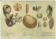 He published his findings with many pictures from his fossil collection, enabling others to investigate their distribution and test his theories. His collection is especially good on Jurassic
fossils he collected from the Cornbrash
, Kimmeridge clay
, Oxford clay
, Oolitic limestone and other horizons in the sequence. They included many types of brachiopod
s, ammonite
s and molluscs characteristic of the shallow seas in which they were deposited. Some of the names he coined (like Cornbrash) are still used today for this formation.
In 1801, he drew a rough sketch of what would become "The Map that Changed the World". Because he was unemployed, he could travel across the length and breadth of the country, while meeting some eminent people such as Thomas Coke, 1st Earl of Leicester
, and the Duke of Bedford
.
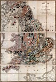 In 1815 he published the first geological map of Britain
. It covered the whole of England and Wales
, and parts of Scotland
. Conventional symbols were used to mark canals, tunnels, tramways and roads, collieries, lead, copper and tin mines, together with salt and alum works. The various geological types were indicated by different colours; the maps were hand coloured. Nevertheless, the map is remarkably similar to modern geological maps of England. He also published his Delineation of the Strata of England in the same year. In another of his books Strata Identified by Organized Fossils (London 1816-1819) he recognised that strata contained distinct fossil assemblages which could be used to match rocks across regions.
In 1817 he drew a remarkable geological section from Snowdon to London. Unfortunately, his maps were soon plagiarised
and sold for prices lower than he was asking. He went into debt and finally became bankrupt.
On 31 August 1819 Smith was released from King's Bench Prison
in London
, a debtor's prison
. He returned to his home of fourteen years at 15 Buckingham Street to find a bailiff
at the door and his home and property seized. Smith then worked as an itinerant surveyor for many years until one of his employers, Sir John Johnstone, recognised him and took steps to gain for him the respect he deserved. Between 1824 and 1826 he lived and worked in Scarborough, and was responsible for the building of the Rotunda
, a geological museum devoted to the Yorkshire coast.The Rotunda was re-opened as 'Rotunda – The William Smith Museum of Geology', on 9 May 2008 by Lord Oxburgh, however, the Prince of Wales visited the Rotunda as early as 14 September 2007 to view the progress of the refurbishment of this listed building.
conferred on Smith the first Wollaston Medal
in recognition of his achievement. It was on this occasion that the President, Adam Sedgwick
, referred to Smith as "the Father of English Geology". Smith travelled to Dublin with the British Association in 1835, and there totally unexpectedly received an honorary Doctorate of Laws (LL.D.) from Trinity College
. In 1838 he was appointed as one of the commissioners to select building-stone for the new Palace of Westminster
. He died in Northampton
, and is buried a few feet from the west tower of St Peter's Church, Marefair
. The inscription on the grave is badly worn but the name "William Smith" can just be seen.
The modern geological map of Britain is based on Smith's original work, his map being displayed at the Geological Society in London
, although now protected by a curtain.
English people
The English are a nation and ethnic group native to England, who speak English. The English identity is of early mediaeval origin, when they were known in Old English as the Anglecynn. England is now a country of the United Kingdom, and the majority of English people in England are British Citizens...
geologist
Geologist
A geologist is a scientist who studies the solid and liquid matter that constitutes the Earth as well as the processes and history that has shaped it. Geologists usually engage in studying geology. Geologists, studying more of an applied science than a theoretical one, must approach Geology using...
, credited with creating the first nationwide geological map. He is known as the "Father of English Geology
Geology
Geology is the science comprising the study of solid Earth, the rocks of which it is composed, and the processes by which it evolves. Geology gives insight into the history of the Earth, as it provides the primary evidence for plate tectonics, the evolutionary history of life, and past climates...
" for collating the geological history of England and Wales
England and Wales
England and Wales is a jurisdiction within the United Kingdom. It consists of England and Wales, two of the four countries of the United Kingdom...
into a single record, although recognition was very slow in coming. At the time his map was first published he was overlooked by the scientific community; his relatively humble education and family connections preventing him from mixing easily in learned society. Consequently his work was plagiarised, he was financially ruined, and he spent time in debtors' prison. It was only much later in his life that Smith received recognition for his accomplishments.
Early life
Smith was born in the village of Churchill, OxfordshireChurchill, Oxfordshire
Churchill is a village and civil parish about southwest of Chipping Norton, Oxfordshire in the Cotswolds Area of Outstanding Natural Beauty.-History:...
, the son of blacksmith John Smith, himself scion of a respectable farming family. His father died when Smith was just eight years old, and he was then raised by his uncle. In 1787, he found work as an assistant for Edward Webb of Stow-on-the-Wold
Stow-on-the-Wold
Stow-on-the-Wold is a market town and civil parish in Gloucestershire, England. It is situated on top of an 800 ft hill, at the convergence of a number of major roads through the Cotswolds, including the Fosse Way . The town was founded as a planned market place by Norman lords to take...
, Gloucestershire
Gloucestershire
Gloucestershire is a county in South West England. The county comprises part of the Cotswold Hills, part of the flat fertile valley of the River Severn, and the entire Forest of Dean....
, a surveyor. He was quick to learn, and soon became proficient at the trade. In 1791, he traveled to Somerset
Somerset
The ceremonial and non-metropolitan county of Somerset in South West England borders Bristol and Gloucestershire to the north, Wiltshire to the east, Dorset to the south-east, and Devon to the south-west. It is partly bounded to the north and west by the Bristol Channel and the estuary of the...
to make a valuation survey of the Sutton Court
Sutton Court
Sutton Court, Stowey, also known as Stowey Court, is a large English house built on the site of a fourteenth century castle, with sections built in the fifteenth and sixteenth century....
estate, and building on earlier work in the same area by John Strachey
John Strachey (geologist)
John Strachey was a British geologist.He was born in Chew Magna, England, a member of the Strachey Baronets. He inherited estates including Sutton Court from his father at three years of age. He matriculated at Trinity College, Oxford and was admitted at Middle Temple, London, in 1688...
. He stayed there for the next eight years, working first for Webb and later for the Somersetshire Coal Canal
Somerset Coal Canal
The Somerset Coal Canal was a narrow canal in England, built around 1800 from basins at Paulton and Timsbury via Camerton, an aqueduct at Dunkerton, Combe Hay, Midford and Monkton Combe to Limpley Stoke where it joined the Kennet and Avon Canal...
Company.
Below is an extract from his writings in which he describes his experiences when living in High Littleton and Bath, Somerset.
I resided from 1791-1795 in a part of the large old manor house belonging to Lady JONES called Rugburn in High Littleton. It was then occupied by a farmer [Cornelius HARRIS], who lodged and boarded me for half a guinea a week and kept my horse for half a crown a week. I have often said that in one respect my residence was the most singular, it being nearer to three cities than any other place in Britain: it is 10 miles from Bath, 10 from Bristol and 12 from Wells. What is called the lower road from Bath to Wells goes through High Littleton but Rugburn old house is a quarter of a mile east of the village and about half way between it and Mearns coal pit. It is a large quadrangular house, I believe with a double M roof; several of the windows used to be darkened [filled up]. There was a square walled court in front with
entrance gates between brick pillars on top of a flight of stone steps and on each side of the gates facing the south was a niche in the wall, where I used to sit and study. On the one side of the court was a row of lime trees, which screened it from the farmyard and the east wind, and on the other side was a large walled garden, and over the road of approach there was an avenue of fine elms all across a large piece of pasture. This had been the coach road when the house was occupied, as I understand, by a Major [Capt. John] BRITTON, who, according to the account of the old farmer, was said to have ruined himself by working the coal upon his own estate [BRITTON's half brother, William JONES of Stowey, baled him out with a loan of £1,200, in return for which BRITTON left JONES his High Littleton estates and lordship of the manor on his death in 1742]. I collected much information from the old colliers respecting the coal, ancient collieries, faults re which I must herein omit; but I must be rather particular in describing the house, through it's relation to the now extensively known science of geology; for, as some of my pupils and friends have called the vicinity of Bath the cradle of geology. I now inform them that RUGBURN WAS IT'S BIRTHPLACE.
Life's work
Smith worked at one of the estate's older mines, the Mearns Pit at High LittletonHigh Littleton
The village of High Littleton and its hamlets of Hallatrow and Amesbury form a civil parish and are located in the county of Somerset and straddle both the A39 and A37, from Bath, from Wells and from Bristol. The parish has a population of 2,086...
, part of the Somerset coalfield
Somerset coalfield
The Somerset Coalfield included pits in the North Somerset, England, area where coal was mined from the 15th century until 1973.It is part of a wider coalfield which covered northern Somerset and southern Gloucestershire. It stretched from Cromhall in the north to the Mendip Hills in the south, and...
and the Somerset Coal Canal
Somerset Coal Canal
The Somerset Coal Canal was a narrow canal in England, built around 1800 from basins at Paulton and Timsbury via Camerton, an aqueduct at Dunkerton, Combe Hay, Midford and Monkton Combe to Limpley Stoke where it joined the Kennet and Avon Canal...
. As he observed the rock layers (or strata
Stratum
In geology and related fields, a stratum is a layer of sedimentary rock or soil with internally consistent characteristics that distinguish it from other layers...
) at the pit, he realised that they were arranged in a predictable pattern and that the various strata could always be found in the same relative positions. Additionally, each particular stratum could be identified by the fossils it contained, and the same succession of fossil
Fossil
Fossils are the preserved remains or traces of animals , plants, and other organisms from the remote past...
groups from older to younger rocks could be found in many parts of England. Furthermore, he noticed an easterly dip of the beds of rock- small near the surface (about three degree
Degree (angle)
A degree , usually denoted by ° , is a measurement of plane angle, representing 1⁄360 of a full rotation; one degree is equivalent to π/180 radians...
s) then bigger after the Triassic
Triassic
The Triassic is a geologic period and system that extends from about 250 to 200 Mya . As the first period of the Mesozoic Era, the Triassic follows the Permian and is followed by the Jurassic. Both the start and end of the Triassic are marked by major extinction events...
rocks. This gave Smith a testable hypothesis, which he termed The Principle of Faunal Succession, and he began his search to determine if the relationships between the strata and their characteristics were consistent throughout the country. During subsequent travels, first as a surveyor (appointed by noted engineer
Engineer
An engineer is a professional practitioner of engineering, concerned with applying scientific knowledge, mathematics and ingenuity to develop solutions for technical problems. Engineers design materials, structures, machines and systems while considering the limitations imposed by practicality,...
John Rennie) for the canal company until 1799 when he was dismissed, and later, he was continually taking samples and mapping the locations of the various strata, and displaying the vertical extent of the strata, and drawing cross-sections and tables of what he saw. This would earn him the name "Strata Smith". As a natural consequence, Smith amassed a large and valuable collection of fossils of the strata he had examined himself from exposures in canals, road
Road
A road is a thoroughfare, route, or way on land between two places, which typically has been paved or otherwise improved to allow travel by some conveyance, including a horse, cart, or motor vehicle. Roads consist of one, or sometimes two, roadways each with one or more lanes and also any...
and railway cutting
Cutting
Cutting is the separation of a physical object, or a portion of a physical object, into two portions, through the application of an acutely directed force. An implement commonly used for cutting is the knife or in medical cases the scalpel...
s, quarries
Quarries
Quarries - The "Royal Quarries" — not found in Scripture — is the namegiven to the vast caverns stretching far underneath the northern hill, Bezetha, on which Jerusalem is built. Out of these mammoth caverns stones, a hard limestone, have been quarried in ancient times for the buildings in the...
and escarpment
Escarpment
An escarpment is a steep slope or long cliff that occurs from erosion or faulting and separates two relatively level areas of differing elevations.-Description and variants:...
s across the country. He also developed methods for the identification of deposits of Fuller's earth
Fuller's earth
Fuller's earth is any non-plastic clay or claylike earthy material used to decolorize, filter, and purify animal, mineral, and vegetable oils and greases.-Occurrence and composition:...
to the south of Bath.
Jurassic
The Jurassic is a geologic period and system that extends from about Mya to Mya, that is, from the end of the Triassic to the beginning of the Cretaceous. The Jurassic constitutes the middle period of the Mesozoic era, also known as the age of reptiles. The start of the period is marked by...
fossils he collected from the Cornbrash
Cornbrash
In geology, Cornbrash was the name applied to the uppermost member of the Bathonian stage of the Jurassic formation in England. It is an old English agricultural name applied in Wiltshire to a variety of loose rubble or brash which, in that part of the country, forms a good soil for growing corn...
, Kimmeridge clay
Kimmeridge Clay
The Kimmeridge Clay Formation is a sedimentary deposit of fossiliferous marine clay which is of Jurassic age. It occurs in Europe.Kimmeridge Clay is arguably the most economically important unit of rocks in the whole of Europe, being the major source rock for oil fields in the North Sea hydrocarbon...
, Oxford clay
Oxford Clay
The Oxford Clay Formation is a Jurassic marine sedimentary rock formation underlying much of southeast England, from as far west as Dorset and as far north as Yorkshire. The Oxford Clay is of middle Callovian to lower Oxfordian age and comprises 2 main facies. The lower facies comprises the...
, Oolitic limestone and other horizons in the sequence. They included many types of brachiopod
Brachiopod
Brachiopods are a phylum of marine animals that have hard "valves" on the upper and lower surfaces, unlike the left and right arrangement in bivalve molluscs. Brachiopod valves are hinged at the rear end, while the front can be opened for feeding or closed for protection...
s, ammonite
Ammonite
Ammonite, as a zoological or paleontological term, refers to any member of the Ammonoidea an extinct subclass within the Molluscan class Cephalopoda which are more closely related to living coleoids Ammonite, as a zoological or paleontological term, refers to any member of the Ammonoidea an extinct...
s and molluscs characteristic of the shallow seas in which they were deposited. Some of the names he coined (like Cornbrash) are still used today for this formation.
Publication and disappointment
In 1799 Smith produced the first large scale geologic map of the area around Bath, Somerset. Previously, he only knew how to draw the vertical extent of the rocks, but not how to display them horizontally. However, in the Somerset County Agricultural Society, he found a map showing the types of soils and vegetation around Bath and their geographical extent. Importantly, the differing types were coloured. Using this technique, Smith could draw a geological map from his observations showing the outcrops of the rocks. He took a few rock types, each with its own colour. Then he estimated the boundaries of each of the outcrops of rock, filled them in with colour and ended up with a crude geological map.In 1801, he drew a rough sketch of what would become "The Map that Changed the World". Because he was unemployed, he could travel across the length and breadth of the country, while meeting some eminent people such as Thomas Coke, 1st Earl of Leicester
Thomas Coke, 1st Earl of Leicester (seventh creation)
Thomas William Coke, 1st Earl of Leicester , known as Coke of Norfolk, was a British politician and agricultural reformer. Born to Wenman Coke, Member of Parliament for Derby and his wife Elizabeth, Coke was educated at several schools, including Eton College, before undertaking a Grand Tour of...
, and the Duke of Bedford
Duke of Bedford
thumb|right|240px|William Russell, 1st Duke of BedfordDuke of Bedford is a title that has been created five times in the Peerage of England. The first creation came in 1414 in favour of Henry IV's third son, John, who later served as regent of France. He was made Earl of Kendal at the same time...
.
Great Britain
Great Britain or Britain is an island situated to the northwest of Continental Europe. It is the ninth largest island in the world, and the largest European island, as well as the largest of the British Isles...
. It covered the whole of England and Wales
England and Wales
England and Wales is a jurisdiction within the United Kingdom. It consists of England and Wales, two of the four countries of the United Kingdom...
, and parts of Scotland
Scotland
Scotland is a country that is part of the United Kingdom. Occupying the northern third of the island of Great Britain, it shares a border with England to the south and is bounded by the North Sea to the east, the Atlantic Ocean to the north and west, and the North Channel and Irish Sea to the...
. Conventional symbols were used to mark canals, tunnels, tramways and roads, collieries, lead, copper and tin mines, together with salt and alum works. The various geological types were indicated by different colours; the maps were hand coloured. Nevertheless, the map is remarkably similar to modern geological maps of England. He also published his Delineation of the Strata of England in the same year. In another of his books Strata Identified by Organized Fossils (London 1816-1819) he recognised that strata contained distinct fossil assemblages which could be used to match rocks across regions.
In 1817 he drew a remarkable geological section from Snowdon to London. Unfortunately, his maps were soon plagiarised
Plagiarism
Plagiarism is defined in dictionaries as the "wrongful appropriation," "close imitation," or "purloining and publication" of another author's "language, thoughts, ideas, or expressions," and the representation of them as one's own original work, but the notion remains problematic with nebulous...
and sold for prices lower than he was asking. He went into debt and finally became bankrupt.
On 31 August 1819 Smith was released from King's Bench Prison
King's Bench Prison
The King's Bench Prison was a prison in Southwark, south London, from medieval times until it closed in 1880. It took its name from the King's Bench court of law in which cases of defamation, bankruptcy and other misdemeanours were heard; as such, the prison was often used as a debtor's prison...
in London
London
London is the capital city of :England and the :United Kingdom, the largest metropolitan area in the United Kingdom, and the largest urban zone in the European Union by most measures. Located on the River Thames, London has been a major settlement for two millennia, its history going back to its...
, a debtor's prison
Debtor's prison
A debtors' prison is a prison for those who are unable to pay a debt.Prior to the mid 19th century debtors' prisons were a common way to deal with unpaid debt.-Debt bondage in ancient Greece and Rome:...
. He returned to his home of fourteen years at 15 Buckingham Street to find a bailiff
Bailiff
A bailiff is a governor or custodian ; a legal officer to whom some degree of authority, care or jurisdiction is committed...
at the door and his home and property seized. Smith then worked as an itinerant surveyor for many years until one of his employers, Sir John Johnstone, recognised him and took steps to gain for him the respect he deserved. Between 1824 and 1826 he lived and worked in Scarborough, and was responsible for the building of the Rotunda
Rotunda Museum
The Rotunda Museum is one of the oldest purpose-built museums still in use in the United Kingdom. The curved grade II* listed building was constructed in 1829 as one of the country's first purpose-built museums...
, a geological museum devoted to the Yorkshire coast.The Rotunda was re-opened as 'Rotunda – The William Smith Museum of Geology', on 9 May 2008 by Lord Oxburgh, however, the Prince of Wales visited the Rotunda as early as 14 September 2007 to view the progress of the refurbishment of this listed building.
Later recognition
It was not until February 1831 that the Geological Society of LondonGeological Society of London
The Geological Society of London is a learned society based in the United Kingdom with the aim of "investigating the mineral structure of the Earth"...
conferred on Smith the first Wollaston Medal
Wollaston Medal
The Wollaston Medal is a scientific award for geology, the highest award granted by the Geological Society of London.The medal is named after William Hyde Wollaston, and was first awarded in 1831...
in recognition of his achievement. It was on this occasion that the President, Adam Sedgwick
Adam Sedgwick
Adam Sedgwick was one of the founders of modern geology. He proposed the Devonian period of the geological timescale...
, referred to Smith as "the Father of English Geology". Smith travelled to Dublin with the British Association in 1835, and there totally unexpectedly received an honorary Doctorate of Laws (LL.D.) from Trinity College
Trinity College, Dublin
Trinity College, Dublin , formally known as the College of the Holy and Undivided Trinity of Queen Elizabeth near Dublin, was founded in 1592 by letters patent from Queen Elizabeth I as the "mother of a university", Extracts from Letters Patent of Elizabeth I, 1592: "...we...found and...
. In 1838 he was appointed as one of the commissioners to select building-stone for the new Palace of Westminster
Palace of Westminster
The Palace of Westminster, also known as the Houses of Parliament or Westminster Palace, is the meeting place of the two houses of the Parliament of the United Kingdom—the House of Lords and the House of Commons...
. He died in Northampton
Northampton
Northampton is a large market town and local government district in the East Midlands region of England. Situated about north-west of London and around south-east of Birmingham, Northampton lies on the River Nene and is the county town of Northamptonshire. The demonym of Northampton is...
, and is buried a few feet from the west tower of St Peter's Church, Marefair
St Peter's Church, Northampton
St Peter's Church, Northampton, is a redundant Anglican church in Marefair, Northampton, England. It has been designated by English Heritage as a Grade I listed building, and is under the care of the Churches Conservation Trust...
. The inscription on the grave is badly worn but the name "William Smith" can just be seen.
The modern geological map of Britain is based on Smith's original work, his map being displayed at the Geological Society in London
London
London is the capital city of :England and the :United Kingdom, the largest metropolitan area in the United Kingdom, and the largest urban zone in the European Union by most measures. Located on the River Thames, London has been a major settlement for two millennia, its history going back to its...
, although now protected by a curtain.
Legacy
- The first geological map of Britain, much copied in his time, and the basis for all others.
- Geological SurveyGeological surveyThe term geological survey can be used to describe both the conduct of a survey for geological purposes and an institution holding geological information....
s around the world owe a debt to his work. - His nephew John PhillipsJohn Phillips (geologist)John Phillips FRS was an English geologist.- Life and work :Philips was born at Marden in Wiltshire...
lived during his youth with William Smith and was his apprentice. John Phillips became a major figure in 19th century geology and paleontology—among other things he's credited as first to specify most of the table of geologic eras that is used today (1841). - A craterImpact craterIn the broadest sense, the term impact crater can be applied to any depression, natural or manmade, resulting from the high velocity impact of a projectile with a larger body...
on MarsMarsMars is the fourth planet from the Sun in the Solar System. The planet is named after the Roman god of war, Mars. It is often described as the "Red Planet", as the iron oxide prevalent on its surface gives it a reddish appearance...
is named after him. (see List of craters on Mars: O-Z#S) - The Geological Society of London presents an annual lecture in his honour.
- In 2005, a William Smith 'facsimile' was created at the Natural History MuseumNatural History MuseumThe Natural History Museum is one of three large museums on Exhibition Road, South Kensington, London, England . Its main frontage is on Cromwell Road...
as a notable gallery character to patrol its displays, among other luminaries such as Carl Linnaeus, Mary AnningMary AnningMary Anning was a British fossil collector, dealer and palaeontologist who became known around the world for a number of important finds she made in the Jurassic age marine fossil beds at Lyme Regis where she lived...
, and Dorothea BateDorothea BateDorothea Minola Alice Bate FGS , also known as Dorothy Bate, was a British palaeontologist, a pioneer of archaeozoology...
.
Other sources
- John L Morton, Strata (New Edition, 2004), Horsham: Brocken Spectre Publishing. ISBN 0-9546829-1-2
- Simon WinchesterSimon WinchesterSimon Winchester, OBE , is a British-American author and journalist who resides mostly in the United States. Through his career at The Guardian, Winchester covered numerous significant events including Bloody Sunday and the Watergate Scandal...
, The Map That Changed the World: William Smith and the Birth of Modern GeologyThe Map that Changed the WorldThe Map that Changed the World is a book by Simon Winchester.It tells the story of geologist William Smith and his great achievement, the first geological map of England and Wales. It was the first national-scale geological map, and by far the most accurate of its time...
, (2001), New York: HarperCollins, ISBN 0-14-028039-1 - John PhillipsJohn Phillips (geologist)John Phillips FRS was an English geologist.- Life and work :Philips was born at Marden in Wiltshire...
, Memoirs of William Smith (1844, republished with additional material by Hugh Torrens, 2003 ISBN 0-9544941-0-5). - William Smith's Private Papers, Oxford University
- A.Taylor, "A History of the Taylor Family", (1986), Privately Published.
External links
- William Smith — a man who changed the world
- Biography of William "Strata" Smith.
- William "Strata" Smith and his achievements in Scarborough.
- Image of Smith's geological map of England and Wales and part of Scotland, published in 1815.
- Full-size replica of Smith's map at the Durham campus of the University of New Hampshire.
- NASA Earth Observatory biography
- NASA Earth Observatory page on William Smith's Geological Map
- Works of William Smith at the Oxford Digital Library