
Wilts and Berks Canal
Encyclopedia
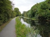
The Wilts & Berks Canal is a canal
in the historic counties
of Wiltshire
and Berkshire
, England
, linking the Kennet and Avon Canal
at Semington
, near Melksham
, to the River Thames
at Abingdon
. The North Wilts Canal merged with it to become a branch to the Thames and Severn Canal
at Latton
near Cricklade
. Among professional trades boatmen, the canal was nicknamed the Ippey Cut, possibly short for Chippenham.
The 52 miles (83.7 km) canal was opened in 1810, but abandoned in 1914 – a fate hastened by the collapse of Stanley aqueduct
in 1901. Much of the canal subsequently became unnavigable: many of the structures were deliberately damaged by army demolition exercises; parts of the route were filled in and in some cases built over. In 1977 the Wilts & Berks Canal Amenity Group
was formed with a view to full restoration of the canal. Several locks and bridges have since been restored, and over 8 miles (12.9 km) of the canal have been rewatered.
empowering construction of the canal received Royal Assent
in 1795. It allowed the company to raise £111,900 through 1,119 shares at a cost of £100 each for the construction of the canal. Another Act of Parliament
was passed in 1801 which allowed the company to raise a further £200,000 to complete the canal.
The canal was cut during the years 1796 to 1810. Robert Whitworth Snr. remained as an engineer on the canal from 1796 to 1799. William Whitworth was resident engineer during this period and, upon Robert's departure, he became engineer until the canal's completion, for which he was paid £255,262.
Following completion, a further two Acts were passed in 1810 and 1813 to alter toll rates on the canal, and another Act was passed in 1815 to allow the company to raise £100,000 to pay off debts collected during the construction of the canal, and to construct a reservoir.
, Calne
, Wantage
and Longcot
. It was cut to take narrowboat
s 72 feet (21.9 m) long and 7 feet (2.1 m) wide. There were 42 locks on the main line and three on the Calne branch. There were three short tunnels.
While the main canal was opened in 1810, some branches were operating before this and others added afterwards. The North Wilts Canal from Swindon
to the Thames and Severn Canal
at Cricklade was opened in 1819; it had 11 locks. It was originally a separate company, but merged with the Wilts & Berks following an Act of Parliament in 1821.
came from the Radstock
and Paulton
mines in the Somerset coalfield
by way of the Somersetshire Coal Canal
, which joined the Kennet and Avon Canal at Dundas
. In 1837 43,642 tons of coal were transported via the Wilts & Berks Canal from the Somerset coalfield
, with 10,669 tons being handled at Abingdon wharf. The Wilts and Berks thus became a link in the "chain" of canals providing a transportation route between the West Country
and the Midlands
. Water supply was always a problem and a reservoir was constructed near Swindon to supply the canal, now known as Coate Water.
The Wilts & Berks Canal was never a great commercial success due to competition from the railways, especially the Great Western Railway
from 1841. In addition, long stretches of the canal were through a type of clay which is unsuitable for lining a canal, and so there was a constant need for puddling, making maintenance costs prohibitive. Despite this, the Wilts & Berks Canal operated for more than a century, but through traffic had pretty much ceased by 1901. In that year the Stanley Aqueduct over the River Marden
collapsed; an event that proved to be the death knell of the canal.
From the early 1930s much of the canal was filled in and generally used for dumping rubbish. Chippenham Wharf, once home to Brinkworth's Coal Depot, was used by residents as a refuse tip, and council minutes from 1926 show a decision to dump pig offal
in the disused waterway. A bus station was built on the site, the buried wharf being uncovered briefly during redevelopment in 2006.
During the Second World War many of the locks and other canal structures were used for army
exercises and damaged by explosives.
Very little of the old canal survived in usable form, but long rural stretches are clearly delineated.
was formed to protect what remained of the canal, and restore short sections for their amenity value. Their first projects included the clearing of sections at Kingshill, Shrivenham, Dauntsey and Wootton Bassett. Ten years later this became a major restoration project.
The Wilts & Berks Canal Trust
was formed in 1997 as a partnership between the W & B Canal Amenity Group and the district and county councils covering the route of the canal. This included the District Councils of North Wilts, West Wilts and Vale of the White Horse, the County Councils of Oxfordshire and Wiltshire, and Swindon Borough Council. The aims of the trust were to protect, conserve and improve the canal and its branches, with the ultimate aim of restoring the whole canal to navigable status. However, the legal structure of the group was unsuitable for accessing some of the grants available for canal restoration, and so it was reformed into the Wilts & Berks Canal Partnership in 2001.
Although development has taken place on some of the land of the canal, much of its route is intact, especially in rural areas. The "line" of the canal has been preserved in Local Development Plans, which means that no new building or development should now take place on the former canal.
The connection of the canal with the River Thames
at Abingdon had been closed by development. On 30 August 2006 the Jubilee Junction was opened providing a new connection with the River Thames further downstream near Culham Lock
. The cut initially runs for about 150 yards (137.2 m) to a winding hole, but will eventually link to the historic route of the canal to the west of Abingdon.
The Trust is progressing with re-watering many of the rural sections, and is working with local councils to construct new sections (possibly including new tunnels) where urban development has made the original route unavailable. Not all development has been urban, however. In Uffington
, for instance, a farm has been built on the old wharf site, over the filled canal.
, a number of bridges and locks have been rebuilt and at least 8 miles (12.9 km) of the canal are in water.
On 26 May 2009, Double Bridge and a short section of rewatered canal was officially opened by the Trust's patron, HRH The Duchess of Cornwall.
There are some significant engineering challenges lying ahead for the Trust, but they offer opportunities to improve the areas surrounding the canal. The M4 motorway
at Swindon was built over the line of the canal. Swindon Council are supporting the restoration of the canal, and are actively planning to route it through the town centre, albeit not quite on the original route. In 2007 a feasibility study suggested that a proposal to construct a canal through Swindon would cost £50m. Despite some objections, Swindon Borough Council gave approval in 2008 for further investigation of the scheme proposed by the Wilts & Berks Canal Trust. The Thames Valley Chamber of Commerce Group also welcomed the project "as a key element in transforming Swindon's town centre into a leisure and visitor attraction, disposing of its dreary reputation."
In Melksham
, where much of the route has been lost to housing, the Town Council has agreed in principle to support plans to route the canal through the River Avon
in the centre of town. A new weir
would raise water levels to permit navigation and an existing weir would be demolished.
The Wilts & Berks Canal Trust has the following active restoration projects:
Note: Much of the route is over land in private ownership with no rights of public access, which may include restoration sites.
The trees that most frequently have to be removed are Salix fragilis (Crack willow), a fast-growing, short-lived member of the Willow family. These have seeded themselves on the towpath side of the canal and may shed large branches in windy weather and are therefore hazardous. Trust Work parties consisting of unpaid volunteers may be called out at short notice to deal with trees that have fallen across the towpath, blocking the way for walkers and cyclists.
The Trust aims to keep local groups and residents informed and involved with the work. Senior members of the Trust regularly give talks and guided walks along the canal. These are intended to show how a linear wildlife corridor can be created from what has formerly been stagnant water with rubbish dumped in it. The phrase used is "not even wildlife likes a stagnant canal"
Objections to a canal route through the town centre are believed to arise from misconception that canals contain "stagnant water". However canals are permanently moving water slowly downstream, and are thus not stagnant. The passage of boats keeps the water stirred up making it muddy-looking, but this is essential to prevent the growth of weeds. In January 2008 Swindon Council considered a report, prepared by their consultants, on the feasibility and implications of restoring the town centre route. They endorsed the proposal, and have set up a task group in order to make further progress.
There is concern in south Oxfordshire about the risk of flooding, and it can be argued that the canal will act as a drainage system, helping to take excess water and move it away to the Thames. The Environment Agency
have expressed concerns about the proposed route of the canal at Melksham, and its effect on the floodplain, and there have been calls from local landowners to ensure that a town-centre route is re-established.
Trust work parties are installing fencing, accommodation bridges, and drainage as well as undertaking tree maintenance and removal where required and this is beneficial to landowners along the line of the canal. Most of the landowners co-operate with the Trust, once they understand the benefits they can gain from a working canal, and are assured that they will not lose any access to or from the fields to either side.
It should not be referred to as the "Wiltshire and Berkshire Canal", but as "the former Wilts & Berks Canal". Likewise the "North Wilts Canal" should not be referred to as the "North Wiltshire Canal".
Following local authority boundary changes in 1973 the part of Berkshire through which the canal passes (mostly the Vale of White Horse
) was transferred to Oxfordshire
. However, the canal's original name is retained for historical reasons.
Canal
Canals are man-made channels for water. There are two types of canal:#Waterways: navigable transportation canals used for carrying ships and boats shipping goods and conveying people, further subdivided into two kinds:...
in the historic counties
Historic counties of England
The historic counties of England are subdivisions of England established for administration by the Normans and in most cases based on earlier Anglo-Saxon kingdoms and shires...
of Wiltshire
Wiltshire
Wiltshire is a ceremonial county in South West England. It is landlocked and borders the counties of Dorset, Somerset, Hampshire, Gloucestershire, Oxfordshire and Berkshire. It contains the unitary authority of Swindon and covers...
and Berkshire
Berkshire
Berkshire is a historic county in the South of England. It is also often referred to as the Royal County of Berkshire because of the presence of the royal residence of Windsor Castle in the county; this usage, which dates to the 19th century at least, was recognised by the Queen in 1957, and...
, England
England
England is a country that is part of the United Kingdom. It shares land borders with Scotland to the north and Wales to the west; the Irish Sea is to the north west, the Celtic Sea to the south west, with the North Sea to the east and the English Channel to the south separating it from continental...
, linking the Kennet and Avon Canal
Kennet and Avon Canal
The Kennet and Avon Canal is a waterway in southern England with an overall length of , made up of two lengths of navigable river linked by a canal. The name is commonly used to refer to the entire length of the navigation rather than solely to the central canal section...
at Semington
Semington Locks
The Semington Locks are situated at Semington, Wiltshire on the Kennet and Avon Canal, England.Both the locks at Semington were built between 1718 and 1723 under the supervision of the engineer John Hore of Newbury...
, near Melksham
Melksham
Melksham is a medium-sized English town, lying on the River Avon. It lies in the county of Wiltshire.It is situated southeast of the city of Bath, south of Chippenham, west of Devizes and north of Warminster on the A350 national route. The 2001 UK census cited Melksham as having 20,000...
, to the River Thames
River Thames
The River Thames flows through southern England. It is the longest river entirely in England and the second longest in the United Kingdom. While it is best known because its lower reaches flow through central London, the river flows alongside several other towns and cities, including Oxford,...
at Abingdon
Abingdon, Oxfordshire
Abingdon or archaically Abingdon-on-Thames is a market town and civil parish in Oxfordshire, England. It is the seat of the Vale of White Horse district. Previously the county town of Berkshire, Abingdon is one of several places that claim to be Britain's oldest continuously occupied town, with...
. The North Wilts Canal merged with it to become a branch to the Thames and Severn Canal
Thames and Severn Canal
The Thames and Severn Canal is a canal in Gloucestershire in the south of England, which was completed in 1789. It was conceived as part of a canal route from Bristol to London. At its eastern end, it connects to the River Thames at Inglesham Lock near Lechlade, while at its western end, it...
at Latton
Latton
Latton may refer to: * Latton, Harlow, a village now situated in Harlow New Town, Essex, England* Latton, Wiltshire, a village near Cricklade in Wiltshire, England...
near Cricklade
Cricklade
Cricklade is a town and civil parish on the River Thames in north Wiltshire in England, midway between Swindon and Cirencester.On 25 September 2011 Cricklade was awarded The Royal Horticultural Society's 'Champion of Champions' award in the Britain in Bloom competition.Cricklade is twinned with...
. Among professional trades boatmen, the canal was nicknamed the Ippey Cut, possibly short for Chippenham.
The 52 miles (83.7 km) canal was opened in 1810, but abandoned in 1914 – a fate hastened by the collapse of Stanley aqueduct
Aqueduct
An aqueduct is a water supply or navigable channel constructed to convey water. In modern engineering, the term is used for any system of pipes, ditches, canals, tunnels, and other structures used for this purpose....
in 1901. Much of the canal subsequently became unnavigable: many of the structures were deliberately damaged by army demolition exercises; parts of the route were filled in and in some cases built over. In 1977 the Wilts & Berks Canal Amenity Group
Wilts & Berks Canal Trust
The Wilts & Berks Canal Trust is a registered charity no. 299595, and a waterway society based in Wiltshire, England, concerned with the restoration of the Wilts & Berks Canal....
was formed with a view to full restoration of the canal. Several locks and bridges have since been restored, and over 8 miles (12.9 km) of the canal have been rewatered.
Construction
A plan for the canal was published by Robert Whitworth Snr. along with William Whitworth in 1793. The BillBill (proposed law)
A bill is a proposed law under consideration by a legislature. A bill does not become law until it is passed by the legislature and, in most cases, approved by the executive. Once a bill has been enacted into law, it is called an act or a statute....
empowering construction of the canal received Royal Assent
Royal Assent
The granting of royal assent refers to the method by which any constitutional monarch formally approves and promulgates an act of his or her nation's parliament, thus making it a law...
in 1795. It allowed the company to raise £111,900 through 1,119 shares at a cost of £100 each for the construction of the canal. Another Act of Parliament
Act of Parliament
An Act of Parliament is a statute enacted as primary legislation by a national or sub-national parliament. In the Republic of Ireland the term Act of the Oireachtas is used, and in the United States the term Act of Congress is used.In Commonwealth countries, the term is used both in a narrow...
was passed in 1801 which allowed the company to raise a further £200,000 to complete the canal.
The canal was cut during the years 1796 to 1810. Robert Whitworth Snr. remained as an engineer on the canal from 1796 to 1799. William Whitworth was resident engineer during this period and, upon Robert's departure, he became engineer until the canal's completion, for which he was paid £255,262.
Following completion, a further two Acts were passed in 1810 and 1813 to alter toll rates on the canal, and another Act was passed in 1815 to allow the company to raise £100,000 to pay off debts collected during the construction of the canal, and to construct a reservoir.
Route
The main canal was 52 miles (83.7 km) long, with branches totalling 6 miles (9.7 km) to ChippenhamChippenham, Wiltshire
Chippenham is a market town in Wiltshire, England, located east of Bath and west of London. In the 2001 census the population of the town was recorded as 28,065....
, Calne
Calne
Calne is a town in Wiltshire, southwestern England. It is situated at the northwestern extremity of the North Wessex Downs hill range, a designated Area of Outstanding Natural Beauty....
, Wantage
Wantage
Wantage is a market town and civil parish in the Vale of the White Horse, Oxfordshire, England. The town is on Letcombe Brook, about south-west of Abingdon and a similar distance west of Didcot....
and Longcot
Longcot
Longcot is a village and civil parish in the Vale of White Horse District. It was part of Berkshire until the 1974 boundary changes transferred it to Oxfordshire. The village is about south of Faringdon and about northeast of Shrivenham. The A420 road between Swindon and Oxford passes through the...
. It was cut to take narrowboat
Narrowboat
A narrowboat or narrow boat is a boat of a distinctive design, made to fit the narrow canals of Great Britain.In the context of British Inland Waterways, "narrow boat" refers to the original working boats built in the 18th, 19th, and 20th centuries for carrying goods on the narrow canals...
s 72 feet (21.9 m) long and 7 feet (2.1 m) wide. There were 42 locks on the main line and three on the Calne branch. There were three short tunnels.
While the main canal was opened in 1810, some branches were operating before this and others added afterwards. The North Wilts Canal from Swindon
Swindon
Swindon is a large town within the borough of Swindon and ceremonial county of Wiltshire, in South West England. It is midway between Bristol, west and Reading, east. London is east...
to the Thames and Severn Canal
Thames and Severn Canal
The Thames and Severn Canal is a canal in Gloucestershire in the south of England, which was completed in 1789. It was conceived as part of a canal route from Bristol to London. At its eastern end, it connects to the River Thames at Inglesham Lock near Lechlade, while at its western end, it...
at Cricklade was opened in 1819; it had 11 locks. It was originally a separate company, but merged with the Wilts & Berks following an Act of Parliament in 1821.
| Key Locations on Route | |||
|---|---|---|---|
| Location | OS Grid Ref British national grid reference system The Ordnance Survey National Grid reference system is a system of geographic grid references used in Great Britain, different from using latitude and longitude.... |
Coordinates Geographic coordinate system A geographic coordinate system is a coordinate system that enables every location on the Earth to be specified by a set of numbers. The coordinates are often chosen such that one of the numbers represent vertical position, and two or three of the numbers represent horizontal position... (Links to map resources) |
Notes |
| Jubilee Junction | SU496949 | 51.651°N 1.282°W | junction with River Thames |
| Wantage | SU384887 | 51.596°N 1.438°W | |
| Shrivenham | SU234880 | 51.590°N 1.662°W | |
| Cricklade | SU104945 | 51.649°N 1.849°W | junction with Thames and Severn Canal |
| SU135834 | 51.549°N 1.805°W | junction with North Wilts Canal | |
| Seven Locks | SU201808 | 51.526°N 1.971°W | |
| Stanley Junction | ST959726 | 51.452°N 2.058°W | junction with Calne branch |
| Semington Junction | ST898610 | 51.348°N 2.146°W | junction with Kennet & Avon Canal |
Operation
CoalCoal
Coal is a combustible black or brownish-black sedimentary rock usually occurring in rock strata in layers or veins called coal beds or coal seams. The harder forms, such as anthracite coal, can be regarded as metamorphic rock because of later exposure to elevated temperature and pressure...
came from the Radstock
Radstock
Radstock is a town in Somerset, England, south west of Bath, and north west of Frome. It is within the unitary authority of Bath and North East Somerset and had a population of 5,275 according to the 2001 Census...
and Paulton
Paulton
Paulton is a large village and civil parish, with a population of 4,896, located to the north of the Mendip Hills, in the unitary authority of Bath and North East Somerset , England....
mines in the Somerset coalfield
Somerset coalfield
The Somerset Coalfield included pits in the North Somerset, England, area where coal was mined from the 15th century until 1973.It is part of a wider coalfield which covered northern Somerset and southern Gloucestershire. It stretched from Cromhall in the north to the Mendip Hills in the south, and...
by way of the Somersetshire Coal Canal
Somerset Coal Canal
The Somerset Coal Canal was a narrow canal in England, built around 1800 from basins at Paulton and Timsbury via Camerton, an aqueduct at Dunkerton, Combe Hay, Midford and Monkton Combe to Limpley Stoke where it joined the Kennet and Avon Canal...
, which joined the Kennet and Avon Canal at Dundas
Dundas Aqueduct
Dundas Aqueduct carries the Kennet and Avon Canal over the River Avon and the Wessex Main Line railway from Bath to Westbury, near Limpley Stoke in Wiltshire, England....
. In 1837 43,642 tons of coal were transported via the Wilts & Berks Canal from the Somerset coalfield
Somerset coalfield
The Somerset Coalfield included pits in the North Somerset, England, area where coal was mined from the 15th century until 1973.It is part of a wider coalfield which covered northern Somerset and southern Gloucestershire. It stretched from Cromhall in the north to the Mendip Hills in the south, and...
, with 10,669 tons being handled at Abingdon wharf. The Wilts and Berks thus became a link in the "chain" of canals providing a transportation route between the West Country
West Country
The West Country is an informal term for the area of south western England roughly corresponding to the modern South West England government region. It is often defined to encompass the historic counties of Cornwall, Devon, Dorset and Somerset and the City of Bristol, while the counties of...
and the Midlands
English Midlands
The Midlands, or the English Midlands, is the traditional name for the area comprising central England that broadly corresponds to the early medieval Kingdom of Mercia. It borders Southern England, Northern England, East Anglia and Wales. Its largest city is Birmingham, and it was an important...
. Water supply was always a problem and a reservoir was constructed near Swindon to supply the canal, now known as Coate Water.
The Wilts & Berks Canal was never a great commercial success due to competition from the railways, especially the Great Western Railway
Great Western Railway
The Great Western Railway was a British railway company that linked London with the south-west and west of England and most of Wales. It was founded in 1833, received its enabling Act of Parliament in 1835 and ran its first trains in 1838...
from 1841. In addition, long stretches of the canal were through a type of clay which is unsuitable for lining a canal, and so there was a constant need for puddling, making maintenance costs prohibitive. Despite this, the Wilts & Berks Canal operated for more than a century, but through traffic had pretty much ceased by 1901. In that year the Stanley Aqueduct over the River Marden
River Marden
The River Marden is a small tributary of the River Avon in England. It flows from the hills surrounding Calne and meets the River Avon about a mile upstream of Chippenham. The river has a mean flow of .-Course:...
collapsed; an event that proved to be the death knell of the canal.
Abandonment
The canal was formally abandoned by an Act of Parliament in 1914. The Act was sponsored by Swindon Corporation, which gained control of all the land within its boundary. In other areas ownership returned to the owners of adjacent land.From the early 1930s much of the canal was filled in and generally used for dumping rubbish. Chippenham Wharf, once home to Brinkworth's Coal Depot, was used by residents as a refuse tip, and council minutes from 1926 show a decision to dump pig offal
Offal
Offal , also called, especially in the United States, variety meats or organ meats, refers to the internal organs and entrails of a butchered animal. The word does not refer to a particular list of edible organs, which varies by culture and region, but includes most internal organs other than...
in the disused waterway. A bus station was built on the site, the buried wharf being uncovered briefly during redevelopment in 2006.
During the Second World War many of the locks and other canal structures were used for army
British Army
The British Army is the land warfare branch of Her Majesty's Armed Forces in the United Kingdom. It came into being with the unification of the Kingdom of England and Scotland into the Kingdom of Great Britain in 1707. The new British Army incorporated Regiments that had already existed in England...
exercises and damaged by explosives.
Very little of the old canal survived in usable form, but long rural stretches are clearly delineated.
Restoration
In 1977 the Wilts & Berks Canal Amenity GroupWilts & Berks Canal Trust
The Wilts & Berks Canal Trust is a registered charity no. 299595, and a waterway society based in Wiltshire, England, concerned with the restoration of the Wilts & Berks Canal....
was formed to protect what remained of the canal, and restore short sections for their amenity value. Their first projects included the clearing of sections at Kingshill, Shrivenham, Dauntsey and Wootton Bassett. Ten years later this became a major restoration project.
The Wilts & Berks Canal Trust
Wilts & Berks Canal Trust
The Wilts & Berks Canal Trust is a registered charity no. 299595, and a waterway society based in Wiltshire, England, concerned with the restoration of the Wilts & Berks Canal....
was formed in 1997 as a partnership between the W & B Canal Amenity Group and the district and county councils covering the route of the canal. This included the District Councils of North Wilts, West Wilts and Vale of the White Horse, the County Councils of Oxfordshire and Wiltshire, and Swindon Borough Council. The aims of the trust were to protect, conserve and improve the canal and its branches, with the ultimate aim of restoring the whole canal to navigable status. However, the legal structure of the group was unsuitable for accessing some of the grants available for canal restoration, and so it was reformed into the Wilts & Berks Canal Partnership in 2001.
Although development has taken place on some of the land of the canal, much of its route is intact, especially in rural areas. The "line" of the canal has been preserved in Local Development Plans, which means that no new building or development should now take place on the former canal.
The connection of the canal with the River Thames
River Thames
The River Thames flows through southern England. It is the longest river entirely in England and the second longest in the United Kingdom. While it is best known because its lower reaches flow through central London, the river flows alongside several other towns and cities, including Oxford,...
at Abingdon had been closed by development. On 30 August 2006 the Jubilee Junction was opened providing a new connection with the River Thames further downstream near Culham Lock
Culham Lock
Culham Lock is a lock on the River Thames in England close to Culham, Oxfordshire. It is on a lock cut to the north of the main stream, which approaches the large village of Sutton Courtenay...
. The cut initially runs for about 150 yards (137.2 m) to a winding hole, but will eventually link to the historic route of the canal to the west of Abingdon.
The Trust is progressing with re-watering many of the rural sections, and is working with local councils to construct new sections (possibly including new tunnels) where urban development has made the original route unavailable. Not all development has been urban, however. In Uffington
Uffington, Oxfordshire
Uffington is a village and civil parish about south of Faringdon. It was part of Berkshire until the 1974 boundary changes transferred it to Oxfordshire. Uffington is most commonly known as the location of the Uffington White Horse hill figure....
, for instance, a farm has been built on the old wharf site, over the filled canal.
, a number of bridges and locks have been rebuilt and at least 8 miles (12.9 km) of the canal are in water.
On 26 May 2009, Double Bridge and a short section of rewatered canal was officially opened by the Trust's patron, HRH The Duchess of Cornwall.
There are some significant engineering challenges lying ahead for the Trust, but they offer opportunities to improve the areas surrounding the canal. The M4 motorway
M4 motorway
The M4 motorway links London with South Wales. It is part of the unsigned European route E30. Other major places directly accessible from M4 junctions are Reading, Swindon, Bristol, Newport, Cardiff and Swansea...
at Swindon was built over the line of the canal. Swindon Council are supporting the restoration of the canal, and are actively planning to route it through the town centre, albeit not quite on the original route. In 2007 a feasibility study suggested that a proposal to construct a canal through Swindon would cost £50m. Despite some objections, Swindon Borough Council gave approval in 2008 for further investigation of the scheme proposed by the Wilts & Berks Canal Trust. The Thames Valley Chamber of Commerce Group also welcomed the project "as a key element in transforming Swindon's town centre into a leisure and visitor attraction, disposing of its dreary reputation."
In Melksham
Melksham
Melksham is a medium-sized English town, lying on the River Avon. It lies in the county of Wiltshire.It is situated southeast of the city of Bath, south of Chippenham, west of Devizes and north of Warminster on the A350 national route. The 2001 UK census cited Melksham as having 20,000...
, where much of the route has been lost to housing, the Town Council has agreed in principle to support plans to route the canal through the River Avon
River Avon, Bristol
The River Avon is an English river in the south west of the country. To distinguish it from a number of other River Avons in Britain, this river is often also known as the Lower Avon or Bristol Avon...
in the centre of town. A new weir
Weir
A weir is a small overflow dam used to alter the flow characteristics of a river or stream. In most cases weirs take the form of a barrier across the river that causes water to pool behind the structure , but allows water to flow over the top...
would raise water levels to permit navigation and an existing weir would be demolished.
The Wilts & Berks Canal Trust has the following active restoration projects:
| Active Restoration Projects | ||
|---|---|---|
| Project | Details | Coordinates Geographic coordinate system A geographic coordinate system is a coordinate system that enables every location on the Earth to be specified by a set of numbers. The coordinates are often chosen such that one of the numbers represent vertical position, and two or three of the numbers represent horizontal position... (Links to map resources) |
| Childrey Wharf | Drainage works and new spill weir | 51.596°N 1.485°W |
| Steppingstones Lane Bridge | Bridge being rebuilt - nearing completion | 51.591°N 1.661°W |
| Latton Basin | 51.658°N 1.875°W | |
| Hayes Knoll Lock | Lock being rebuilt | 51.615°N 1.850°W |
| River Ray Valley, Moredon | Joint project between the Trust and BBC Breathing Spaces | 51.582°N 1.820°W |
| Chaddington Lane spill weir and canal | Lock and Spill weir rebuilt, dredging and reprofiling of canal in progress. | 51.532°N 1.863°W |
| Seven Locks, Lynham | Lock chambers 3 & 4 now rebuilt. Lock 2 and bridge to be redesigned & rebuilt. | 51.526°N 1.972°W |
| Pewsham Locks and canal | 3 locks, a bridge, a dry dock, a spill weir and a culvert undergoing restoration. | 51.438°N 2.092°W |
| Restored & new sections in water | ||
|---|---|---|
| Location | Details | Coordinates Geographic coordinate system A geographic coordinate system is a coordinate system that enables every location on the Earth to be specified by a set of numbers. The coordinates are often chosen such that one of the numbers represent vertical position, and two or three of the numbers represent horizontal position... (Links to map resources) |
| Jubilee Junction | 150 yards (137.2 m) of new canal and winding hole constructed. Navigable from River Thames. | 51.651°N 1.282°W |
| Temple Firs section | 1250 yards (1,143 m) of canal restored | 51.534°N 1.890°W |
| Dauntsey section | 770 yards (704.1 m) in water - has a land-locked narrow boat! | 51.520°N 2.010°W |
| Foxham section | 770 yards (704.1 m) in water | 51.502°N 2.033°W |
| Double Bridge & Naish Hill section | Bridge & 550 yards (502.9 m) of canal restored | 51.429°N 2.102°W |
Note: Much of the route is over land in private ownership with no rights of public access, which may include restoration sites.
Restoration issues
There is some controversy about the restoration of the canal, in particular the felling of trees and the corresponding short-term disruption of wildlife habitats that have evolved in the 100 or so years since the canal was abandoned, and this has been addressed in the North Wiltshire Local Plan.The trees that most frequently have to be removed are Salix fragilis (Crack willow), a fast-growing, short-lived member of the Willow family. These have seeded themselves on the towpath side of the canal and may shed large branches in windy weather and are therefore hazardous. Trust Work parties consisting of unpaid volunteers may be called out at short notice to deal with trees that have fallen across the towpath, blocking the way for walkers and cyclists.
The Trust aims to keep local groups and residents informed and involved with the work. Senior members of the Trust regularly give talks and guided walks along the canal. These are intended to show how a linear wildlife corridor can be created from what has formerly been stagnant water with rubbish dumped in it. The phrase used is "not even wildlife likes a stagnant canal"
Objections to a canal route through the town centre are believed to arise from misconception that canals contain "stagnant water". However canals are permanently moving water slowly downstream, and are thus not stagnant. The passage of boats keeps the water stirred up making it muddy-looking, but this is essential to prevent the growth of weeds. In January 2008 Swindon Council considered a report, prepared by their consultants, on the feasibility and implications of restoring the town centre route. They endorsed the proposal, and have set up a task group in order to make further progress.
There is concern in south Oxfordshire about the risk of flooding, and it can be argued that the canal will act as a drainage system, helping to take excess water and move it away to the Thames. The Environment Agency
Environment Agency
The Environment Agency is a British non-departmental public body of the Department for Environment, Food and Rural Affairs and an Assembly Government Sponsored Body of the Welsh Assembly Government that serves England and Wales.-Purpose:...
have expressed concerns about the proposed route of the canal at Melksham, and its effect on the floodplain, and there have been calls from local landowners to ensure that a town-centre route is re-established.
Trust work parties are installing fencing, accommodation bridges, and drainage as well as undertaking tree maintenance and removal where required and this is beneficial to landowners along the line of the canal. Most of the landowners co-operate with the Trust, once they understand the benefits they can gain from a working canal, and are assured that they will not lose any access to or from the fields to either side.
Name
The official name of the canal was always "Wilts & Berks Canal" as cited in the Acts of Parliament that authorised its building and abandonment.It should not be referred to as the "Wiltshire and Berkshire Canal", but as "the former Wilts & Berks Canal". Likewise the "North Wilts Canal" should not be referred to as the "North Wiltshire Canal".
Following local authority boundary changes in 1973 the part of Berkshire through which the canal passes (mostly the Vale of White Horse
Vale of White Horse
The Vale of White Horse is a local government district of Oxfordshire in England. The main town is Abingdon, other places include Faringdon and Wantage. There are 68 parishes within the district...
) was transferred to Oxfordshire
Oxfordshire
Oxfordshire is a county in the South East region of England, bordering on Warwickshire and Northamptonshire , Buckinghamshire , Berkshire , Wiltshire and Gloucestershire ....
. However, the canal's original name is retained for historical reasons.
See also
- Canals of Great Britain
- History of the British canal systemHistory of the British canal systemThe British canal system of water transport played a vital role in the United Kingdom's Industrial Revolution at a time when roads were only just emerging from the medieval mud and long trains of pack horses were the only means of "mass" transit by road of raw materials and finished products The...
External links
- Wilts & Berks Canal Trust – Official website
- A Brief History of the Wilts & Berks Canal, (Peter Scatchard, W&BCT)
- Trading on the Wilts & Berks canal
Restoration progress
- Wilts & Berks Canal Trust – Official website: overview of current projects
- W&BCT: Melksham, Calne and Chippenham Branch
- W&BCT: East Vale Branch – Jubilee Junction (River Thames) to Childrey
- W&BCT: Cricklade Branch – North Wilts Canal
- W&BCT: Swindon Branch – Illustrated description of the proposed route through Swindon.