
Timsbury, Somerset
Encyclopedia
Timsbury is a village and civil parish in the Bath and North East Somerset
unitary authority
of the county of Somerset
, 8 miles (13 km) south-west of Bath England. The parish, which includes the hamlets
of Meadgate, Radford and Wall Mead, has a population of 2,581.
Timsbury has been a settlement since the Bronze Age
. Some of the earliest written records show an entry in the Norman Domesday Book
of 1086.
The entry then goes on to describe the Mill at Radford which is to the south of the village.
The parish was part of the hundred of Chew
.
Timsbury House was a large mansion house owned by the Samborne family. Built towards the end of the 15th century by Richard Samborne. His successor Barnaby Samborne was knighted for his services to Queen Elizabeth I
. The building was demolished in 1961, and St. Marys Green and Somerset Folly estates now occupy the original site. One unusual feature of the estate was the presence of a ha-ha (sunken path). This was constructed to allow the Samborne family privacy from the local inhabitants as they passed the house.
Pitfour House in the High street was built in the mid 17th century. The terrace of houses at Crook Barton dates back to around 1700.
In 1795, the Gooseyard bridge in Timsbury parish was the starting point for the Somerset Coal Canal
which served the seven coal
mines at Amesbury, Mearns, Tyning, Hayeswood, Old Grove, and Upper and Lower Conygre, around the village which formed a major part of the Somerset Coalfield
. Lower Conygre (Conigre in some old spellings) was sunk in 1847 and in 1896 was merged with the older Upper Congyre which had been started in 1791. They were owned by Samborne Smith and Company in 1908, and then by Beaumont, Kennedy and Co. The Amesbury pit opened before 1701 and closed in the early 19th century. Hayeswood colliery opened in 1750 and closed in 1862. Tyning opened in 1766 followed by Mearns which was sunk in 1783 and closed in 1824.
The canal was later replaced by a railway line in the early 1900s, the Great Western Railway
Radford and Timsbury Halt served the needs of passengers from the village. The Coal canal brought prosperity to the village and several other large houses were built in the area. Renny's on Love's Hill, as was its neighbour, Vale House.
Parish's House on the south eastern side of the village was a 1816 extension of a much earlier house. It is attributed to Thomas Baldwin
of Bath for Captain Parish R.N.
, is fronted by an ornate balustrade
, and includes a stable block from the same date.
Greenhill House was also constructed in the early 1800s. Originally owned by St Johns Hospital
in Bath, it has passed through the hands of various institutions during its history. It was eventually purchased by the charity originally known as The Cheshire Foundation Homes for the Sick, in 1976 it became the Leonard Cheshire Foundation. In July 2007 it changed to its current name, Leonard Cheshire Disability
.
In 1978, the core of the village, centred around the Square and the High Street, was designated a conservation area
, which is now considered "at risk". Many of its buildings constructed from the local White Lias
stone in the 1700s are now protected from inappropriate development.
The Miners Memorial Garden, close to the Square, marks the village's long association with coal mining. It was in built in 1995 to mark the centenary of an underground explosion at Upper Conygre pit in 1895, which claimed the lives of seven miners and four horses.
groups on matters of crime, security, and traffic. The parish council's role also includes initiating projects for the maintenance and repair of parish facilities, such as the village hall
or community centre
, playing field
s and playground
s, as well as consulting with the district council on the maintenance, repair, and improvement of highways, drainage, footpaths, public transport, and street cleaning. Conservation matters (including trees and listed buildings) and environmental issues are also of interest to the council.
The parish falls within the unitary authority
of Bath and North East Somerset
which was created in 1996, as established by the Local Government Act 1992. It provides a single tier of local government
with responsibility for almost all local government functions within its area including local planning
and building control, local roads, council housing, environmental health
, market
s and fairs, refuse collection, recycling
, cemeteries, crematoria, leisure services, parks, and tourism
. They are also responsible for education
, social services, libraries
, main roads, public transport
, trading standards
, waste disposal and strategic planning, although fire, police and ambulance services are provided jointly with other authorities through the Avon Fire and Rescue Service
, Avon and Somerset Constabulary
and the Great Western Ambulance Service
.
Bath and North East Somerset's area covers part of the ceremonial county
of Somerset
but it is administered independently of the non-metropolitan county. Its administrative headquarters is in Bath. Between 1 April 1974 and 1 April 1996, it was the Wansdyke
district and the City of Bath of the county of Avon. Before 1974 that the parish was part of the Clutton Rural District
.
The parish is represented in the House of Commons
of the Parliament of the United Kingdom
as part of North East Somerset
. It elects one Member of Parliament (MP)
by the first past the post system of election. It is also part of the South West England constituency
of the European Parliament
which elects seven MEPs using the d'Hondt method
of party-list proportional representation
.
, to the north is Marksbury
plain. Bordered by two water courses, to the north by the Conygre Brook, and to the south by the Cam Brook. Local landmarks to the north west include the Sleight, a small escarpment rising to 645 feet (196.6 m) for a distance of 0.89 miles (1.4 km) in an east westerly direction. This ridge leads the B3130 to the west of Timsbury past the Hayeswood Road Industrial Estate to connect with the A39
. To the east is Tunley hill which rises to a height of 550 feet (167.6 m), this is the easterly route to Bath via the B3130.
There is some remaining managed woodland in the local area, but nothing like the amount there was in the past when the village was given its name of Timsbyre (wooded hillside). Dutch elm disease and the use of wood for building construction, fuel and furniture has denuded much of the local area of its trees.
period, known as White Lias
limestone. It is close to the surface on the southern slopes of the village, and has been used extensively for building purposes for hundreds of years. Some of it has undergone slight metamorphic
transformation and has become quite hardened. This factor is evident in many of the older buildings where the softer layer stone has more readily eroded in places. There is an abundance of freestone (rubble stone) in many of the local fields, and this has provided much of the walling stone for the local farms.
, Timsbury has a temperate climate
which is generally wetter and milder than the rest of England. The annual mean temperature is about 10 °C (50 °F) with seasonal and diurnal
variations, but due to the modifying effect of the sea, the range is less than in most other parts of the United Kingdom. January is the coldest month with mean minimum temperatures between 1 °C (34 °F) and 2 °C (36 °F). July and August are the warmest months in the region with mean daily maxima around 21 °C (70 °F). In general, December is the dullest month and June the sunniest. The south west of England enjoys a favoured location, particularly in summer, when the Azores High
extends its influence north-eastwards towards the UK.
Cloud
often forms inland, especially near hills, and reduces exposure to sunshine. The average annual sunshine totals around 1600 hours. Rainfall
tends to be associated with Atlantic depressions
or with convection. In summer, convection caused by solar surface heating sometimes forms shower clouds and a large proportion of the annual precipitation falls from showers and thunderstorms at this time of year. Average rainfall is around 800–900 mm (31–35 in). About 8–15 days of snowfall is typical. November to March have the highest mean wind speeds, with June to August having the lightest. The predominant wind direction is from the south west.
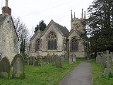
The parish church, dedicated to St Mary, was rebuilt in 1826–32 and the east end added in 1852 by Sir George Gilbert Scott
. It has been designated by English Heritage
as a Grade II* listed building. In the churchyard are monuments to James Collins, Robert Langford, the Parsons family, two Smith monuments and one unidentified. The rectory dates from around 1820. South road Methodist Church hall is home to various local groups including the Timsbury Ladies Choir.
The village currently (2010) maintains a pre-school and primary school, a village hall and Youth club hall. The Conygre hall is used for village meetings, shows including antique fairs, flower shows and the village amateur dramatic society performances and local art group exhibitions. It has been extended in recent years and its other uses include short mat bowling, dance classes and also the local polling station.
The Conygre hall was built in 1973 and took its name from the Upper Conygre pit previously located opposite. Its cost was financed equally by local subscription, and the generosity of Major B.G.S. Cayzer, he was the second son of the Union Castle Shipping Line
family and owned Parish's House. It is located in a former Miners welfare field purchased for their benefit and financed by a levy of a penny per ton of all coal mined in the local area. There are facilities for recreation and sport, including two football pitches, cricket
and rugby
. There are two tennis
courts and a well equipped enclosed children's play park area.
There is a social hall for a branch of the British Legion in Newmans lane. Two public houses are the Seven Stars on North road and the Guss and Crook on South road. The Matthews Brewery was built in 2005, on the site of the former Hayeswood Colliery. The brewery was acquired and renamed Dawkins Ales by the Bristol-based, independent Dawkins pubs group in early 2010.
Statistical data (2007) provided by Bath and North East Somerset local authority shows that Timsbury, (area 90 in the data), has above average access to local Authority services, has good health care facilities, a lower than average crime rate and good environmental living standards. Timsbury has its own pharmacy in the High Street and doctors' surgery in St Marys Close.
Bath and North East Somerset
Bath and North East Somerset is a unitary authority that was created on 1 April 1996 following the abolition of the County of Avon. It is part of the Ceremonial county of Somerset...
unitary authority
Unitary authority
A unitary authority is a type of local authority that has a single tier and is responsible for all local government functions within its area or performs additional functions which elsewhere in the relevant country are usually performed by national government or a higher level of sub-national...
of the county of Somerset
Somerset
The ceremonial and non-metropolitan county of Somerset in South West England borders Bristol and Gloucestershire to the north, Wiltshire to the east, Dorset to the south-east, and Devon to the south-west. It is partly bounded to the north and west by the Bristol Channel and the estuary of the...
, 8 miles (13 km) south-west of Bath England. The parish, which includes the hamlets
Hamlet (place)
A hamlet is usually a rural settlement which is too small to be considered a village, though sometimes the word is used for a different sort of community. Historically, when a hamlet became large enough to justify building a church, it was then classified as a village...
of Meadgate, Radford and Wall Mead, has a population of 2,581.
History
The village has been known as Timfborough, Tymmersbarue, Timsbarrow (meaning Timbered grove), Timsbyre (wooded hillside) and Temsbury throughout its long history.Timsbury has been a settlement since the Bronze Age
Bronze Age
The Bronze Age is a period characterized by the use of copper and its alloy bronze as the chief hard materials in the manufacture of some implements and weapons. Chronologically, it stands between the Stone Age and Iron Age...
. Some of the earliest written records show an entry in the Norman Domesday Book
Domesday Book
Domesday Book , now held at The National Archives, Kew, Richmond upon Thames in South West London, is the record of the great survey of much of England and parts of Wales completed in 1086...
of 1086.
"Williams holds Timsbury from the Bishop of Coutance. Ape held it before 1066. It paid tax for 3 hides, land for 3 ploughs, in lordship, 1 plough, 2 slaves, one and one half hides, 2 villagers and 1 smallholder with 1 plough and one and one half hides, 2 parts of a mill which pays two shillings, meadow 26 acres. Pasture as well, 1 cob, 9 cattle, 14 pigs and 60 sheep, the value was 26 shillings, now 50 shillings."
The entry then goes on to describe the Mill at Radford which is to the south of the village.
The parish was part of the hundred of Chew
Chew (hundred)
The Hundred of Chew is one of the 40 historical Hundreds in the ceremonial county of Somerset, England, dating from before the Norman conquest during the Anglo-Saxon era although exact dates are unknown. Each hundred had a 'fyrd', which acted as the local defence force and a court which was...
.
Timsbury House was a large mansion house owned by the Samborne family. Built towards the end of the 15th century by Richard Samborne. His successor Barnaby Samborne was knighted for his services to Queen Elizabeth I
Elizabeth I of England
Elizabeth I was queen regnant of England and Ireland from 17 November 1558 until her death. Sometimes called The Virgin Queen, Gloriana, or Good Queen Bess, Elizabeth was the fifth and last monarch of the Tudor dynasty...
. The building was demolished in 1961, and St. Marys Green and Somerset Folly estates now occupy the original site. One unusual feature of the estate was the presence of a ha-ha (sunken path). This was constructed to allow the Samborne family privacy from the local inhabitants as they passed the house.
Pitfour House in the High street was built in the mid 17th century. The terrace of houses at Crook Barton dates back to around 1700.
In 1795, the Gooseyard bridge in Timsbury parish was the starting point for the Somerset Coal Canal
Somerset Coal Canal
The Somerset Coal Canal was a narrow canal in England, built around 1800 from basins at Paulton and Timsbury via Camerton, an aqueduct at Dunkerton, Combe Hay, Midford and Monkton Combe to Limpley Stoke where it joined the Kennet and Avon Canal...
which served the seven coal
Coal
Coal is a combustible black or brownish-black sedimentary rock usually occurring in rock strata in layers or veins called coal beds or coal seams. The harder forms, such as anthracite coal, can be regarded as metamorphic rock because of later exposure to elevated temperature and pressure...
mines at Amesbury, Mearns, Tyning, Hayeswood, Old Grove, and Upper and Lower Conygre, around the village which formed a major part of the Somerset Coalfield
Somerset coalfield
The Somerset Coalfield included pits in the North Somerset, England, area where coal was mined from the 15th century until 1973.It is part of a wider coalfield which covered northern Somerset and southern Gloucestershire. It stretched from Cromhall in the north to the Mendip Hills in the south, and...
. Lower Conygre (Conigre in some old spellings) was sunk in 1847 and in 1896 was merged with the older Upper Congyre which had been started in 1791. They were owned by Samborne Smith and Company in 1908, and then by Beaumont, Kennedy and Co. The Amesbury pit opened before 1701 and closed in the early 19th century. Hayeswood colliery opened in 1750 and closed in 1862. Tyning opened in 1766 followed by Mearns which was sunk in 1783 and closed in 1824.
The canal was later replaced by a railway line in the early 1900s, the Great Western Railway
Great Western Railway
The Great Western Railway was a British railway company that linked London with the south-west and west of England and most of Wales. It was founded in 1833, received its enabling Act of Parliament in 1835 and ran its first trains in 1838...
Radford and Timsbury Halt served the needs of passengers from the village. The Coal canal brought prosperity to the village and several other large houses were built in the area. Renny's on Love's Hill, as was its neighbour, Vale House.
Parish's House on the south eastern side of the village was a 1816 extension of a much earlier house. It is attributed to Thomas Baldwin
Thomas Baldwin (architect)
Thomas Baldwin was an English surveyor and architect in Bath.He did not originally hail from Bath but was first recorded in the city in 1774, where he was initially a clerk to plumber, glazier, and politician Thomas Warr Attwood. By 1775, he was appointed as the Bath City Architect after...
of Bath for Captain Parish R.N.
Royal Navy
The Royal Navy is the naval warfare service branch of the British Armed Forces. Founded in the 16th century, it is the oldest service branch and is known as the Senior Service...
, is fronted by an ornate balustrade
Baluster
A baluster is a moulded shaft, square or of lathe-turned form, one of various forms of spindle in woodwork, made of stone or wood and sometimes of metal, standing on a unifying footing, and supporting the coping of a parapet or the handrail of a staircase. Multiplied in this way, they form a...
, and includes a stable block from the same date.
Greenhill House was also constructed in the early 1800s. Originally owned by St Johns Hospital
St John's Hospital, Bath
St John's Hospital in Bath, Somerset, England, was founded around 1180, by Bishop Reginald Fitz Jocelin and is among the oldest almshouses in England...
in Bath, it has passed through the hands of various institutions during its history. It was eventually purchased by the charity originally known as The Cheshire Foundation Homes for the Sick, in 1976 it became the Leonard Cheshire Foundation. In July 2007 it changed to its current name, Leonard Cheshire Disability
Leonard Cheshire Disability
Leonard Cheshire Disability is a major health and welfare charity in the United Kingdom, founded in 1948 by RAF pilot Leonard Cheshire VC.In 2006–7 it had a total expenditure of £143 million, placing it in the top 30 of UK charities.-History:...
.
In 1978, the core of the village, centred around the Square and the High Street, was designated a conservation area
Conservation Area (United Kingdom)
In the United Kingdom, the term Conservation Area nearly always applies to an area considered worthy of preservation or enhancement because of its special architectural or historic interest, "the character or appearance of which it is desirable to preserve or enhance," as required by the Planning ...
, which is now considered "at risk". Many of its buildings constructed from the local White Lias
Lias Group
The Lias Group or Lias is a lithostratigraphic unit found in a large area of western Europe, including the British Isles, the North Sea, the low countries and the north of Germany...
stone in the 1700s are now protected from inappropriate development.
The Miners Memorial Garden, close to the Square, marks the village's long association with coal mining. It was in built in 1995 to mark the centenary of an underground explosion at Upper Conygre pit in 1895, which claimed the lives of seven miners and four horses.
Governance
Since 1894, the parish council has responsibility for local issues, including setting an annual precept (local rate) to cover the council’s operating costs and producing annual accounts for public scrutiny. The parish council evaluates local planning applications and works with the local police, district council officers, and neighbourhood watchNeighbourhood Watch (UK)
The Neighbourhood Watch scheme in the United Kingdom is a partnership where people come together to make their communities safer. It involves the Police, Community Safety departments of local authorities, other voluntary organisations and, above all, individuals and families who want to make their...
groups on matters of crime, security, and traffic. The parish council's role also includes initiating projects for the maintenance and repair of parish facilities, such as the village hall
Village hall
In the United States, a village hall is the seat of government for villages. It functions much as a city hall does within cities.In the United Kingdom, a village hall is usually a building within a village which contains at least one large room, usually owned by and run for the benefit of the local...
or community centre
Community centre
Community centres or community centers or jumping recreation centers are public locations where members of a community tend to gather for group activities, social support, public information, and other purposes. They may sometimes be open for the whole community or for a specialised group within...
, playing field
Playing field
A playing field is a field used for playing sports or games. They are generally outdoors, but many large structures exist to enclose playing fields from bad weather. Generally, playing fields are wide expanses of grass, dirt or sand without many obstructions...
s and playground
Playground
A playground or play area is a place with a specific design for children be able to play there. It may be indoors but is typically outdoors...
s, as well as consulting with the district council on the maintenance, repair, and improvement of highways, drainage, footpaths, public transport, and street cleaning. Conservation matters (including trees and listed buildings) and environmental issues are also of interest to the council.
The parish falls within the unitary authority
Unitary authority
A unitary authority is a type of local authority that has a single tier and is responsible for all local government functions within its area or performs additional functions which elsewhere in the relevant country are usually performed by national government or a higher level of sub-national...
of Bath and North East Somerset
Bath and North East Somerset
Bath and North East Somerset is a unitary authority that was created on 1 April 1996 following the abolition of the County of Avon. It is part of the Ceremonial county of Somerset...
which was created in 1996, as established by the Local Government Act 1992. It provides a single tier of local government
Local government in the United Kingdom
The pattern of local government in England is complex, with the distribution of functions varying according to the local arrangements. Legislation concerning local government in England is decided by the Parliament and Government of the United Kingdom, because England does not have a devolved...
with responsibility for almost all local government functions within its area including local planning
Planning permission
Planning permission or planning consent is the permission required in the United Kingdom in order to be allowed to build on land, or change the use of land or buildings. Within the UK the occupier of any land or building will need title to that land or building , but will also need "planning...
and building control, local roads, council housing, environmental health
Environmental health
Environmental health is the branch of public health that is concerned with all aspects of the natural and built environment that may affect human health...
, market
Market
A market is one of many varieties of systems, institutions, procedures, social relations and infrastructures whereby parties engage in exchange. While parties may exchange goods and services by barter, most markets rely on sellers offering their goods or services in exchange for money from buyers...
s and fairs, refuse collection, recycling
Recycling
Recycling is processing used materials into new products to prevent waste of potentially useful materials, reduce the consumption of fresh raw materials, reduce energy usage, reduce air pollution and water pollution by reducing the need for "conventional" waste disposal, and lower greenhouse...
, cemeteries, crematoria, leisure services, parks, and tourism
Tourism
Tourism is travel for recreational, leisure or business purposes. The World Tourism Organization defines tourists as people "traveling to and staying in places outside their usual environment for not more than one consecutive year for leisure, business and other purposes".Tourism has become a...
. They are also responsible for education
Local Education Authority
A local education authority is a local authority in England and Wales that has responsibility for education within its jurisdiction...
, social services, libraries
Library
In a traditional sense, a library is a large collection of books, and can refer to the place in which the collection is housed. Today, the term can refer to any collection, including digital sources, resources, and services...
, main roads, public transport
Public transport
Public transport is a shared passenger transportation service which is available for use by the general public, as distinct from modes such as taxicab, car pooling or hired buses which are not shared by strangers without private arrangement.Public transport modes include buses, trolleybuses, trams...
, trading standards
Trading Standards
Trading Standards is the name given to local authority departments in the UK formerly known as Weights and Measures. These departments investigate commercial organisations that carry out trade in unethical ways or outside the scope of the law.-History:...
, waste disposal and strategic planning, although fire, police and ambulance services are provided jointly with other authorities through the Avon Fire and Rescue Service
Avon Fire and Rescue Service
Avon Fire & Rescue Service is the fire and rescue service covering the unitary authorities of Bath and North East Somerset, Bristol, North Somerset, and South Gloucestershire in South West England.-History:...
, Avon and Somerset Constabulary
Avon and Somerset Constabulary
Avon & Somerset Constabulary is the territorial police force in England responsible for policing the non-metropolitan county of Somerset, the city & county of Bristol and the unitary authorities of South Gloucestershire, North Somerset and Bath and North East Somerset; before 1996 these districts...
and the Great Western Ambulance Service
Great Western Ambulance Service
The Great Western Ambulance Service NHS Trust is a UK National Health Service trust providing emergency and non emergency patient transport services to Bath and North East Somerset, Bristol, Gloucestershire, North Somerset, Swindon and Wiltshire in the South West England region...
.
Bath and North East Somerset's area covers part of the ceremonial county
Ceremonial counties of England
The ceremonial counties are areas of England to which are appointed a Lord Lieutenant, and are defined by the government as counties and areas for the purposes of the Lieutenancies Act 1997 with reference to the metropolitan and non-metropolitan counties of England and Lieutenancies Act 1997...
of Somerset
Somerset
The ceremonial and non-metropolitan county of Somerset in South West England borders Bristol and Gloucestershire to the north, Wiltshire to the east, Dorset to the south-east, and Devon to the south-west. It is partly bounded to the north and west by the Bristol Channel and the estuary of the...
but it is administered independently of the non-metropolitan county. Its administrative headquarters is in Bath. Between 1 April 1974 and 1 April 1996, it was the Wansdyke
Wansdyke (district)
Wansdyke was a non-metropolitan district within the County of Avon, in the west of England from 1974 to 1996.The district was formed by the Local Government Act 1972 on 1 April 1974 as part of a reform of local authorities throughout England and Wales...
district and the City of Bath of the county of Avon. Before 1974 that the parish was part of the Clutton Rural District
Clutton Rural District
Clutton was a rural district in Somerset, England, from 1894 to 1974.It was created in 1894 under the Local Government Act 1894 as a successor to the rural sanitary district.In 1974 it was abolished under the Local Government Act 1972...
.
The parish is represented in the House of Commons
British House of Commons
The House of Commons is the lower house of the Parliament of the United Kingdom, which also comprises the Sovereign and the House of Lords . Both Commons and Lords meet in the Palace of Westminster. The Commons is a democratically elected body, consisting of 650 members , who are known as Members...
of the Parliament of the United Kingdom
Parliament of the United Kingdom
The Parliament of the United Kingdom of Great Britain and Northern Ireland is the supreme legislative body in the United Kingdom, British Crown dependencies and British overseas territories, located in London...
as part of North East Somerset
North East Somerset (UK Parliament constituency)
North East Somerset is a county constituency created by the Boundary Commission for England as the successor seat to the Wansdyke Parliamentary Seat. It came into being at the 2010 general election.- Boundaries :...
. It elects one Member of Parliament (MP)
Member of Parliament
A Member of Parliament is a representative of the voters to a :parliament. In many countries with bicameral parliaments, the term applies specifically to members of the lower house, as upper houses often have a different title, such as senate, and thus also have different titles for its members,...
by the first past the post system of election. It is also part of the South West England constituency
South West England (European Parliament constituency)
South West England is a constituency of the European Parliament. For 2009 it elects 6 MEPs using the d'Hondt method of party-list proportional representation, reduced from 7 in 2004.-Boundaries:...
of the European Parliament
European Parliament
The European Parliament is the directly elected parliamentary institution of the European Union . Together with the Council of the European Union and the Commission, it exercises the legislative function of the EU and it has been described as one of the most powerful legislatures in the world...
which elects seven MEPs using the d'Hondt method
D'Hondt method
The d'Hondt method is a highest averages method for allocating seats in party-list proportional representation. The method described is named after Belgian mathematician Victor D'Hondt who described it in 1878...
of party-list proportional representation
Party-list proportional representation
Party-list proportional representation systems are a family of voting systems emphasizing proportional representation in elections in which multiple candidates are elected...
.
Geography
The village is located on a plateau 500 feet (152.4 m) above sea level in the north east of Somerset. To the south is the northern edge of the Mendip HillsMendip Hills
The Mendip Hills is a range of limestone hills to the south of Bristol and Bath in Somerset, England. Running east to west between Weston-super-Mare and Frome, the hills overlook the Somerset Levels to the south and the Avon Valley to the north...
, to the north is Marksbury
Marksbury
Marksbury is a small village and civil parish in Somerset about from Keynsham and from Bath on the A39 where it meets the A368. The parish, which includes the villages of Hunstrete and Stanton Prior, has a population of 399.- History :...
plain. Bordered by two water courses, to the north by the Conygre Brook, and to the south by the Cam Brook. Local landmarks to the north west include the Sleight, a small escarpment rising to 645 feet (196.6 m) for a distance of 0.89 miles (1.4 km) in an east westerly direction. This ridge leads the B3130 to the west of Timsbury past the Hayeswood Road Industrial Estate to connect with the A39
A39 road
The A39 is an A road in south west England. It runs south-west from Bath in Somerset through Wells, Glastonbury, Street and Bridgwater. It then follows the north coast of Somerset and Devon through Williton, Minehead, Porlock, Lynmouth, Barnstaple, Bideford, Stratton, Camelford, Wadebridge and St...
. To the east is Tunley hill which rises to a height of 550 feet (167.6 m), this is the easterly route to Bath via the B3130.
There is some remaining managed woodland in the local area, but nothing like the amount there was in the past when the village was given its name of Timsbyre (wooded hillside). Dutch elm disease and the use of wood for building construction, fuel and furniture has denuded much of the local area of its trees.
Geology
The local underlying stone is of the TriassicTriassic
The Triassic is a geologic period and system that extends from about 250 to 200 Mya . As the first period of the Mesozoic Era, the Triassic follows the Permian and is followed by the Jurassic. Both the start and end of the Triassic are marked by major extinction events...
period, known as White Lias
Lias Group
The Lias Group or Lias is a lithostratigraphic unit found in a large area of western Europe, including the British Isles, the North Sea, the low countries and the north of Germany...
limestone. It is close to the surface on the southern slopes of the village, and has been used extensively for building purposes for hundreds of years. Some of it has undergone slight metamorphic
Metamorphic rock
Metamorphic rock is the transformation of an existing rock type, the protolith, in a process called metamorphism, which means "change in form". The protolith is subjected to heat and pressure causing profound physical and/or chemical change...
transformation and has become quite hardened. This factor is evident in many of the older buildings where the softer layer stone has more readily eroded in places. There is an abundance of freestone (rubble stone) in many of the local fields, and this has provided much of the walling stone for the local farms.
Climate
Along with the rest of South West EnglandClimate of south-west England
The climate of south-west England is classed as oceanic according to the Köppen climate classification. The oceanic climate is typified by cool winters with warmer summers and precipitation all year round, with more experienced in winter. Annual rainfall is about and up to on higher ground...
, Timsbury has a temperate climate
Temperate
In geography, temperate or tepid latitudes of the globe lie between the tropics and the polar circles. The changes in these regions between summer and winter are generally relatively moderate, rather than extreme hot or cold...
which is generally wetter and milder than the rest of England. The annual mean temperature is about 10 °C (50 °F) with seasonal and diurnal
Diurnal motion
Diurnal motion is an astronomical term referring to the apparent daily motion of stars around the Earth, or more precisely around the two celestial poles. It is caused by the Earth's rotation on its axis, so every star apparently moves on a circle, that is called the diurnal circle. The time for...
variations, but due to the modifying effect of the sea, the range is less than in most other parts of the United Kingdom. January is the coldest month with mean minimum temperatures between 1 °C (34 °F) and 2 °C (36 °F). July and August are the warmest months in the region with mean daily maxima around 21 °C (70 °F). In general, December is the dullest month and June the sunniest. The south west of England enjoys a favoured location, particularly in summer, when the Azores High
Azores High
The Azores High is a large subtropical semi-permanent centre of high atmospheric pressure found near the Azores in the Atlantic Ocean, at the Horse latitudes...
extends its influence north-eastwards towards the UK.
Cloud
Cumulus cloud
Cumulus clouds are a type of cloud with noticeable vertical development and clearly defined edges. Cumulus means "heap" or "pile" in Latin. They are often described as "puffy" or "cotton-like" in appearance. Cumulus clouds may appear alone, in lines, or in clusters...
often forms inland, especially near hills, and reduces exposure to sunshine. The average annual sunshine totals around 1600 hours. Rainfall
Precipitation (meteorology)
In meteorology, precipitation In meteorology, precipitation In meteorology, precipitation (also known as one of the classes of hydrometeors, which are atmospheric water phenomena is any product of the condensation of atmospheric water vapor that falls under gravity. The main forms of precipitation...
tends to be associated with Atlantic depressions
Low pressure area
A low-pressure area, or "low", is a region where the atmospheric pressure at sea level is below that of surrounding locations. Low-pressure systems form under areas of wind divergence which occur in upper levels of the troposphere. The formation process of a low-pressure area is known as...
or with convection. In summer, convection caused by solar surface heating sometimes forms shower clouds and a large proportion of the annual precipitation falls from showers and thunderstorms at this time of year. Average rainfall is around 800–900 mm (31–35 in). About 8–15 days of snowfall is typical. November to March have the highest mean wind speeds, with June to August having the lightest. The predominant wind direction is from the south west.
Local amenities
Timsbury has five churches catering for various denominations and two cemeteries.The parish church, dedicated to St Mary, was rebuilt in 1826–32 and the east end added in 1852 by Sir George Gilbert Scott
George Gilbert Scott
Sir George Gilbert Scott was an English architect of the Victorian Age, chiefly associated with the design, building and renovation of churches, cathedrals and workhouses...
. It has been designated by English Heritage
English Heritage
English Heritage . is an executive non-departmental public body of the British Government sponsored by the Department for Culture, Media and Sport...
as a Grade II* listed building. In the churchyard are monuments to James Collins, Robert Langford, the Parsons family, two Smith monuments and one unidentified. The rectory dates from around 1820. South road Methodist Church hall is home to various local groups including the Timsbury Ladies Choir.
The village currently (2010) maintains a pre-school and primary school, a village hall and Youth club hall. The Conygre hall is used for village meetings, shows including antique fairs, flower shows and the village amateur dramatic society performances and local art group exhibitions. It has been extended in recent years and its other uses include short mat bowling, dance classes and also the local polling station.
The Conygre hall was built in 1973 and took its name from the Upper Conygre pit previously located opposite. Its cost was financed equally by local subscription, and the generosity of Major B.G.S. Cayzer, he was the second son of the Union Castle Shipping Line
Union-Castle Line
The Union-Castle Line was a prominent British shipping line that operated a fleet of passenger liners and cargo ships between Europe and Africa from 1900 to 1977. It was formed from the merger of the Union Line and Castle Shipping Line...
family and owned Parish's House. It is located in a former Miners welfare field purchased for their benefit and financed by a levy of a penny per ton of all coal mined in the local area. There are facilities for recreation and sport, including two football pitches, cricket
Cricket
Cricket is a bat-and-ball game played between two teams of 11 players on an oval-shaped field, at the centre of which is a rectangular 22-yard long pitch. One team bats, trying to score as many runs as possible while the other team bowls and fields, trying to dismiss the batsmen and thus limit the...
and rugby
Rugby football
Rugby football is a style of football named after Rugby School in the United Kingdom. It is seen most prominently in two current sports, rugby league and rugby union.-History:...
. There are two tennis
Tennis
Tennis is a sport usually played between two players or between two teams of two players each . Each player uses a racket that is strung to strike a hollow rubber ball covered with felt over a net into the opponent's court. Tennis is an Olympic sport and is played at all levels of society at all...
courts and a well equipped enclosed children's play park area.
There is a social hall for a branch of the British Legion in Newmans lane. Two public houses are the Seven Stars on North road and the Guss and Crook on South road. The Matthews Brewery was built in 2005, on the site of the former Hayeswood Colliery. The brewery was acquired and renamed Dawkins Ales by the Bristol-based, independent Dawkins pubs group in early 2010.
Statistical data (2007) provided by Bath and North East Somerset local authority shows that Timsbury, (area 90 in the data), has above average access to local Authority services, has good health care facilities, a lower than average crime rate and good environmental living standards. Timsbury has its own pharmacy in the High Street and doctors' surgery in St Marys Close.
Notable residents
- Singer Susan ChilcottSusan ChilcottSusan Chilcott was an English soprano, considered one of the best of her generation. She died of breast cancer at the age of 40...
was born in the village in 1963 - Entertainer Fred WedlockFred WedlockFred Wedlock was a folk singer best known for his UK hit single "The Oldest Swinger In Town". Wedlock performed at many venues in Britain and Europe, presented programmes for West Country TV and acted with the Bristol Old Vic and the Ministry of Entertainment, as well as undertaking after-dinner...
(deceased) - Actor Anthony HeadAnthony HeadAnthony Stewart Head , usually credited as Anthony Head, is an English actor and musician. He rose to fame in the UK following his role in television advertisements for Nescafé Gold Blend , and is known for his roles as Rupert Giles in Buffy the Vampire Slayer and as Uther Pendragon in...
- Mark Boyle, freeconomy activist