
Midford
Encyclopedia
Midford is a village approximately 3 miles (5 km) miles south south east of Bath, Somerset
, England within the Cotswold
Area of Outstanding Natural Beauty
(AONB). Although a relatively small hamlet, it extends over 2 counties (Wiltshire
and Somerset), is part of two unitary authorities
(Wiltshire and Bath and North East Somerset
) and is part of five parishes (Southstoke
, Hinton Charterhouse
, Wellow
, Freshford
and Limpley Stoke
). Most of the residents reside in the parish of Southstoke and are part of the Bath and North East Somerset unitary authority.
The Cam and Wellow Brooks merge in Midford to form the Midford Brook
, which then flows down to join the River Avon close to the village of Monkton Combe
. The houses & cottages of the village are spread over the gentle valleys of these brooks, which were known as the Valley of the Nightingales in the 1970s but sadly their song is rarely heard nowadays.
and close by are the remains of a lesser viaduct that once carried the Somerset Coal Canal
, and later the Great Western
branch line from Limpley Stoke
to Hallatrow. Midford railway station
, on the S&DJR line served the village until 1966. That line is now on the route of NCR 24, the Colliers Way.
 For about four years from 1911 to 1915, Midford had a second railway station: Midford Halt railway station
on the Limpley Stoke to Camerton railway that followed the former Somerset Coal Canal
. At Camerton it made an end-on junction with a branch from Hallatrow on the former Bristol & North Somerset Railway. The line was open to passenger traffic for only seven years in all, from 1910 to 1915, and from 1923 to 1925. Midford Halt opened a year late and then did not reopen for the second period. Midford Halt was in Wiltshire
; the county boundary runs up to the B3110 road at the point where the canal/railway crossed the road, and the halt was on the Wiltshire side.
, a late 18th-century folly
castle built in the shape of the ace of clubs
(♣). The castle was built in 1775 by Henry Disney Roebuck. It was owned by the Briggs family who spent 45 years restoring the castle, before its sale in July 2007, to actor Nicolas Cage
for £5 million. It changed hands again in 2009.
To the west of the village is upper Midford. Here in 1995 plans were made to create a new plantation to be known as Millenium Wood. In 2000, land between Midford, Southstoke, and Combe Hay was prepared and planted with a variety of native trees and shrubs. This Area of Outstanding Natural Beauty
is open to the public all year round and is crossed by several public footpaths. The site overlooks the Cam brook and the restored remains of the Somerset Coal Canal
as well as the 40ft high viaduct built in 1908 that carried the Somerset & Dorset Railway line across the valley.
To the east of Midford village along the restored canal bed and towpath is Packhorse bridge
, now closed to foot traffic but still intact. Further along the towpath is the fully restored Midford Aqueduct. A lottery grant and other funding was made available to local volunteers and building professionals who completed the work in 2001 at a cost of £1,000,000. It was the most substantial single structure built during the late 18th century Somerset Coal Canal project and was officially opened in 1803. The railway lines that meet and cross each other in the village were the site of the opening scene in the classic 1950s British comedy film, the Titfield Thunderbolt, and much of the surrounding countryside was used as the backdrop for many other scenes in the movie.
. The mines extended nearly 20 acres (8.1 ha) through four adits. In 1915 the works was taken over by the Fuller's Earth Union and despite geological problems continued until the end of World War II
. At the bottom of the valley was the pan grinding works where water from Horsecombe Brook was used to make a slurry from which sand settled at the bottom of troughs. The slurry then passed through an earthenware pipe to Tucking Mill
just beyond Midford, where a second stage of sedimentation took place.
(sustainable transport) organisation to link with an existing cycle route to the City of Bath via the Two Tunnels Greenway
. The project will re-open the old Devonshire, Combe Down and Claverton railway tunnels to make the new link.
in the village: the Hope and Anchor which is on the main road leading into the village, adjacent to the railway bridge and cycle path route.
Somerset
The ceremonial and non-metropolitan county of Somerset in South West England borders Bristol and Gloucestershire to the north, Wiltshire to the east, Dorset to the south-east, and Devon to the south-west. It is partly bounded to the north and west by the Bristol Channel and the estuary of the...
, England within the Cotswold
Cotswold
The Cotswolds are a range of hills in central England that give their name to:*Cotswold *Cotswold *Cotswold Chase, a horse race*Cotswold Games, annual games in Chipping Campden, Gloucestershire...
Area of Outstanding Natural Beauty
Area of Outstanding Natural Beauty
An Area of Outstanding Natural Beauty is an area of countryside considered to have significant landscape value in England, Wales or Northern Ireland, that has been specially designated by the Countryside Agency on behalf of the United Kingdom government; the Countryside Council for Wales on...
(AONB). Although a relatively small hamlet, it extends over 2 counties (Wiltshire
Wiltshire
Wiltshire is a ceremonial county in South West England. It is landlocked and borders the counties of Dorset, Somerset, Hampshire, Gloucestershire, Oxfordshire and Berkshire. It contains the unitary authority of Swindon and covers...
and Somerset), is part of two unitary authorities
Unitary authority
A unitary authority is a type of local authority that has a single tier and is responsible for all local government functions within its area or performs additional functions which elsewhere in the relevant country are usually performed by national government or a higher level of sub-national...
(Wiltshire and Bath and North East Somerset
Bath and North East Somerset
Bath and North East Somerset is a unitary authority that was created on 1 April 1996 following the abolition of the County of Avon. It is part of the Ceremonial county of Somerset...
) and is part of five parishes (Southstoke
Southstoke
Southstoke is a small village and civil parish in north east Somerset, England. In 2004 the parish council requested that the name be formally changed to South Stoke, as "this is historically the more established spelling and better reflects the origin and meaning of the Parish name."It is south...
, Hinton Charterhouse
Hinton Charterhouse
Hinton Charterhouse is a small village and civil parish in the Bath and North East Somerset unitary authority, Somerset, England. The parish, which includes the village of Midford, has a population of 477....
, Wellow
Wellow, Somerset
Wellow is a village and civil parish in Somerset, England, about south of Bath. The parish, which includes the hamlet of Twinhoe has a population of 511...
, Freshford
Freshford
Freshford is a village and civil parish in the Avon valley south-east of Bath, in the county of Somerset, England. The parish has a population of 530...
and Limpley Stoke
Limpley Stoke
Limpley Stoke is a village and civil parish in Wiltshire, in the Avon Valley, between Bath and Freshford. The village is below the A36 road.The civil parish, which had a population of 637 in 2001, also includes the hamlet of Waterhouse, and the outskirts of the Somerset village of Midford. The 18th...
). Most of the residents reside in the parish of Southstoke and are part of the Bath and North East Somerset unitary authority.
The Cam and Wellow Brooks merge in Midford to form the Midford Brook
Midford Brook
Midford Brook is a small river in Somerset, England.It is formed by convergence of the Wellow Brook and Cam Brook at Midford before passing Tucking Mill and joining the River Avon close to the Dundas Aqueduct and the remains of the Somerset Coal Canal....
, which then flows down to join the River Avon close to the village of Monkton Combe
Monkton Combe
Monkton Combe is a village and civil parish in north Somerset, England, south of Bath. The parish, which includes the hamlet of Tucking Mill, has a population of 356.-History:Monkton Combe was part of the hundred of Bath Forum.According to Rev...
. The houses & cottages of the village are spread over the gentle valleys of these brooks, which were known as the Valley of the Nightingales in the 1970s but sadly their song is rarely heard nowadays.
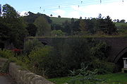
Railways and canal
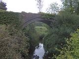
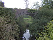
In the village, straddling the B3110 road, is the disused viaduct of the Somerset and Dorset Joint RailwaySomerset and Dorset Joint Railway
The Somerset & Dorset Joint Railway – almost always referred to as "the S&D" – was an English railway line connecting Bath in north east Somerset and Bournemouth now in south east Dorset but then in Hampshire...
and close by are the remains of a lesser viaduct that once carried the Somerset Coal Canal
Somerset Coal Canal
The Somerset Coal Canal was a narrow canal in England, built around 1800 from basins at Paulton and Timsbury via Camerton, an aqueduct at Dunkerton, Combe Hay, Midford and Monkton Combe to Limpley Stoke where it joined the Kennet and Avon Canal...
, and later the Great Western
Great Western Railway
The Great Western Railway was a British railway company that linked London with the south-west and west of England and most of Wales. It was founded in 1833, received its enabling Act of Parliament in 1835 and ran its first trains in 1838...
branch line from Limpley Stoke
Limpley Stoke
Limpley Stoke is a village and civil parish in Wiltshire, in the Avon Valley, between Bath and Freshford. The village is below the A36 road.The civil parish, which had a population of 637 in 2001, also includes the hamlet of Waterhouse, and the outskirts of the Somerset village of Midford. The 18th...
to Hallatrow. Midford railway station
Midford railway station
Midford railway station was a single-platform station on the Bath extension of the Somerset and Dorset Railway, just to the north of the point where the double-track became a single track. It served the village of Midford...
, on the S&DJR line served the village until 1966. That line is now on the route of NCR 24, the Colliers Way.
Midford Halt railway station
Midford Halt railway station existed for four years between 1911 to 1915. The halt was situated on the Limpley Stoke to Camerton railway that formed part of the Great Western Railway's development of the former Bristol and North Somerset Railway, and which followed the former Somerset Coal Canal...
on the Limpley Stoke to Camerton railway that followed the former Somerset Coal Canal
Somerset Coal Canal
The Somerset Coal Canal was a narrow canal in England, built around 1800 from basins at Paulton and Timsbury via Camerton, an aqueduct at Dunkerton, Combe Hay, Midford and Monkton Combe to Limpley Stoke where it joined the Kennet and Avon Canal...
. At Camerton it made an end-on junction with a branch from Hallatrow on the former Bristol & North Somerset Railway. The line was open to passenger traffic for only seven years in all, from 1910 to 1915, and from 1923 to 1925. Midford Halt opened a year late and then did not reopen for the second period. Midford Halt was in Wiltshire
Wiltshire
Wiltshire is a ceremonial county in South West England. It is landlocked and borders the counties of Dorset, Somerset, Hampshire, Gloucestershire, Oxfordshire and Berkshire. It contains the unitary authority of Swindon and covers...
; the county boundary runs up to the B3110 road at the point where the canal/railway crossed the road, and the halt was on the Wiltshire side.
Places of interest
On the hillside above Midford is Midford CastleMidford Castle
Midford Castle is a folly castle in the village of Midford, and the parish of Southstoke south of Bath, Somerset, England.The castle was built in 1775 for Henry Disney Roebuck from designs by John Carter in the shape of the "clubs" symbol used in playing cards...
, a late 18th-century folly
Folly
In architecture, a folly is a building constructed primarily for decoration, but either suggesting by its appearance some other purpose, or merely so extravagant that it transcends the normal range of garden ornaments or other class of building to which it belongs...
castle built in the shape of the ace of clubs
Ace
An ace is a playing card. In the standard French deck, an ace has a single suit symbol located in the middle of the card, sometimes large and decorated, especially in the case of the Ace of Spades...
(♣). The castle was built in 1775 by Henry Disney Roebuck. It was owned by the Briggs family who spent 45 years restoring the castle, before its sale in July 2007, to actor Nicolas Cage
Nicolas Cage
Nicolas Cage is an American actor, producer and director, having appeared in over 60 films including Raising Arizona , The Rock , Face/Off , Gone in 60 Seconds , Adaptation , National Treasure , Ghost Rider , Bad Lieutenant: Port of Call New Orleans , and...
for £5 million. It changed hands again in 2009.
To the west of the village is upper Midford. Here in 1995 plans were made to create a new plantation to be known as Millenium Wood. In 2000, land between Midford, Southstoke, and Combe Hay was prepared and planted with a variety of native trees and shrubs. This Area of Outstanding Natural Beauty
Area of Outstanding Natural Beauty
An Area of Outstanding Natural Beauty is an area of countryside considered to have significant landscape value in England, Wales or Northern Ireland, that has been specially designated by the Countryside Agency on behalf of the United Kingdom government; the Countryside Council for Wales on...
is open to the public all year round and is crossed by several public footpaths. The site overlooks the Cam brook and the restored remains of the Somerset Coal Canal
Somerset Coal Canal
The Somerset Coal Canal was a narrow canal in England, built around 1800 from basins at Paulton and Timsbury via Camerton, an aqueduct at Dunkerton, Combe Hay, Midford and Monkton Combe to Limpley Stoke where it joined the Kennet and Avon Canal...
as well as the 40ft high viaduct built in 1908 that carried the Somerset & Dorset Railway line across the valley.
To the east of Midford village along the restored canal bed and towpath is Packhorse bridge
Packhorse bridge
A packhorse bridge is a bridge intended to carry packhorses across a river or stream. Typically a packhorse bridge consists of one or more narrow masonry arches, and has low parapets so as not to interfere with the horse's panniers.Packhorse bridges were often built on the trade routes that...
, now closed to foot traffic but still intact. Further along the towpath is the fully restored Midford Aqueduct. A lottery grant and other funding was made available to local volunteers and building professionals who completed the work in 2001 at a cost of £1,000,000. It was the most substantial single structure built during the late 18th century Somerset Coal Canal project and was officially opened in 1803. The railway lines that meet and cross each other in the village were the site of the opening scene in the classic 1950s British comedy film, the Titfield Thunderbolt, and much of the surrounding countryside was used as the backdrop for many other scenes in the movie.
Fuller's earth in Horsecombe Vale
In 1883 George Dames and his brother Charles Richard Dames leased land in Horsecombe Vale from the Midford Castle estate and opened a mine and processing works for Fuller's earthFuller's earth
Fuller's earth is any non-plastic clay or claylike earthy material used to decolorize, filter, and purify animal, mineral, and vegetable oils and greases.-Occurrence and composition:...
. The mines extended nearly 20 acres (8.1 ha) through four adits. In 1915 the works was taken over by the Fuller's Earth Union and despite geological problems continued until the end of World War II
World War II
World War II, or the Second World War , was a global conflict lasting from 1939 to 1945, involving most of the world's nations—including all of the great powers—eventually forming two opposing military alliances: the Allies and the Axis...
. At the bottom of the valley was the pan grinding works where water from Horsecombe Brook was used to make a slurry from which sand settled at the bottom of troughs. The slurry then passed through an earthenware pipe to Tucking Mill
Tucking Mill
Tucking Mill is a small hamlet within the parish of Monkton Combe, Somerset, England. It lies on Midford Brook and was a key point on the now disused Somerset Coal Canal....
just beyond Midford, where a second stage of sedimentation took place.
Transport links
Midford is one of the starting points for a project by SustransSustrans
Sustrans is a British charity to promote sustainable transport. The charity is currently working on a number of practical projects to encourage people to walk, cycle and use public transport, to give people the choice of "travelling in ways that benefit their health and the environment"...
(sustainable transport) organisation to link with an existing cycle route to the City of Bath via the Two Tunnels Greenway
Two Tunnels Greenway
The Two Tunnels Greenway is a shared use path for walking and cycling under construction in Bath, Somerset, England.-Route:The route will follow the disused railway trackbed of the Somerset and Dorset Joint Railway from East Twerton through the Bath suburb of Oldfield Park to the Devonshire Tunnel...
. The project will re-open the old Devonshire, Combe Down and Claverton railway tunnels to make the new link.
Local amenities
There is one public housePublic house
A public house, informally known as a pub, is a drinking establishment fundamental to the culture of Britain, Ireland, Australia and New Zealand. There are approximately 53,500 public houses in the United Kingdom. This number has been declining every year, so that nearly half of the smaller...
in the village: the Hope and Anchor which is on the main road leading into the village, adjacent to the railway bridge and cycle path route.
Further reading
- Somerset Railway Stations, by Mike Oakley. Wimborne, Dorset: Dovecote Press (2002)
- Wiltshire Railway Stations, by Mike Oakley. Wimborne, Dorset: Dovecote Press