
Tunstead, Norfolk
Encyclopedia
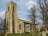
Tunstead is a village and a civil parish
in the English
county of Norfolk
. The village is 10.7 miles north north east of the city of Norwich
, 15 miles south south east of Cromer
and 129 miles north east of London. Tunstead is 2.5 miles north of the settlements of Wroxham
and Hoveton
.
The nearest railway station is at Wroxham & Hoveton
for the Bittern Line
which runs between Sheringham
, Cromer
and Norwich. The nearest airport is Norwich International Airport
.
For the purposes of local government, the parish falls within the district
of North Norfolk
. At the time of the 2001 census
, the parish had a population of 674.
Civil parish
In England, a civil parish is a territorial designation and, where they are found, the lowest tier of local government below districts and counties...
in the English
England
England is a country that is part of the United Kingdom. It shares land borders with Scotland to the north and Wales to the west; the Irish Sea is to the north west, the Celtic Sea to the south west, with the North Sea to the east and the English Channel to the south separating it from continental...
county of Norfolk
Norfolk
Norfolk is a low-lying county in the East of England. It has borders with Lincolnshire to the west, Cambridgeshire to the west and southwest and Suffolk to the south. Its northern and eastern boundaries are the North Sea coast and to the north-west the county is bordered by The Wash. The county...
. The village is 10.7 miles north north east of the city of Norwich
Norwich
Norwich is a city in England. It is the regional administrative centre and county town of Norfolk. During the 11th century, Norwich was the largest city in England after London, and one of the most important places in the kingdom...
, 15 miles south south east of Cromer
Cromer
Cromer is a coastal town and civil parish in north Norfolk, England. The local government authority is North Norfolk District Council, whose headquarters is in Holt Road in the town. The town is situated 23 miles north of the county town, Norwich, and is 4 miles east of Sheringham...
and 129 miles north east of London. Tunstead is 2.5 miles north of the settlements of Wroxham
Wroxham
Wroxham is a village and civil parish in the English county of Norfolk. The civil parish of Wroxham has an area of 6.21 square kilometres and in 2001 had a population of 1532 in 666 households. The village is situated within the Norfolk Broads on the south side of a loop in the middle reaches of...
and Hoveton
Hoveton
Hoveton is a village and civil parish in the English county of Norfolk. It is located within the Norfolk Broads, and immediately across the River Bure from the village of Wroxham...
.
The nearest railway station is at Wroxham & Hoveton
Hoveton and Wroxham railway station
Hoveton and Wroxham is a railway station serving the town of Wroxham in the English county of Norfolk. The station is technically situated in the adjacent village of Hoveton, but the two settlements are usually regarded as one....
for the Bittern Line
Bittern Line
The Bittern Line is a railway line from Norwich to Cromer then Sheringham in Norfolk, England. It is one of the most scenic in the East of England traversing the Norfolk Broads on its route to the Area of Outstanding Natural Beauty on the North Norfolk Coast. The line is part of the Network Rail...
which runs between Sheringham
Sheringham
Sheringham is a seaside town in Norfolk, England, west of Cromer.The motto of the town, granted in 1953 to the Sheringham Urban District Council, is Mare Ditat Pinusque Decorat, Latin for "The sea enriches and the pine adorns"....
, Cromer
Cromer
Cromer is a coastal town and civil parish in north Norfolk, England. The local government authority is North Norfolk District Council, whose headquarters is in Holt Road in the town. The town is situated 23 miles north of the county town, Norwich, and is 4 miles east of Sheringham...
and Norwich. The nearest airport is Norwich International Airport
Norwich International Airport
Norwich International Airport , also known as Norwich Airport, is an airport in the City of Norwich within Norfolk, England north of the city centre and on the edge of the city's suburbs....
.
For the purposes of local government, the parish falls within the district
Non-metropolitan district
Non-metropolitan districts, or colloquially shire districts, are a type of local government district in England. As created, they are sub-divisions of non-metropolitan counties in a so-called "two-tier" arrangement...
of North Norfolk
North Norfolk
North Norfolk is a local government district in Norfolk, United Kingdom. Its council is based in Cromer. The council headquarters can be found approximately out of the town of Cromer on the Holt Road.-History:...
. At the time of the 2001 census
United Kingdom Census 2001
A nationwide census, known as Census 2001, was conducted in the United Kingdom on Sunday, 29 April 2001. This was the 20th UK Census and recorded a resident population of 58,789,194....
, the parish had a population of 674.