

Skinnand
Encyclopedia
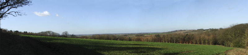
Skinnand is a deserted medieval village
in Lincolnshire
. Originally a small farming community situated 9 miles (14 km) south of Lincoln
and 11.5 miles (19 km) northwest of Sleaford
, it once boasted a church and several houses. It was hit hard, however, by the English Civil War
of 1642-1646, when the church fell into ruins. Today only fields and one deserted farmhouse remain of the once thriving community.
, in about 600 BC. The remains of Iron Age
farms have been found at nearby Navenby
, 2.5 miles (4 km) west of Skinnand, as well as Bronze Age
and Roman
remains. Skinnand was recorded as "Schinende" in the Domesday Book
of 1086, a name thought to be of Anglo-Saxon
origin. Historians believe the original name may have come from the Old Scandinavian word "skinnari," which means "skinner or tanner."
Records show that the village of Skinnand had up to six houses before the English Civil War, most built as small single-storey stone dwellings with thatched roofs. Two, however, were much larger. One was owned by a John Chester, which boasted four domestic rooms with 'upper chambers,' and the other was the parsonage. The parsonage included a hall, two parlours, a kitchen, buttery, milkhouse, brewhouse and stable. It also had three upstairs rooms, as well as an orchard, garden, yard and dovecote. It is believed the parsonage was pulled down, however, during the Civil War and, by the time of the Hearth Tax returns of 1665, there were just three houses in Skinnand.
Details about the Norman
-built Anglican church of Skinnand are sketchy, although it was reputedly dedicated to St Matthew and burned down by Oliver Cromwell
's forces in the 1640s. Historical records certainly show that it had begun to fall into ruins in the 17th century - at around the time of the Civil War. The Glebe Terrier documents of 1700 recorded: "The church was in ruins, no house for the rector, more than this we find not, all the buildings being long since disappeared." Despite the disappearance of the church, parish registers reveal that services were still held throughout the 19th century, at the home of Skinnand man John Woolfit. The Skinnand burial ground was also in use until 1911.
, just south of Navenby, and at Carlton-le-Moorland
and Bassingham
- each village several miles walk away.
As a result of the 1834 Poor Law Amendment Act, the parish became part of the Lincoln Poor Law Union and, by the mid-19th century, Skinnand was a struggling parish
in the Higher division of the wapentake of Boothby Graffoe
. According to the Institute of Historical Research, it consisted of 636 acres (2.6 km²), of which 40 were arable and the rest "old pasture and meadow." The records add: "The living is a discharged rectory, valued in the King's books at £5. 13. 11½.; net income, £85; patron, S. Nicholls, Esq. The church is in ruins."
Just a few years later, in 1871, it was recorded that "just a few stones remain to mark the location" of the old church. In the same year, the Census showed that the parish now consisted of only three farms, all belonging to Mr S. Nicholls of London
. Other surnames in the parish at that time included Clawson, Burt and Picker.
was the principal landowner. The village was occupied for just a few more years, however, before the final families moved out. Today, just a boarded up old farm house stands where the thriving community of Skinnand once was.
of Skinnand was originally in the higher division of the ancient Boothby Graffoe
wapentake, in the North Kesteven
division of the county of Lincolnshire. The term wapentake dates back to the Vikings and was used to describe a collection of local parishes. It originally meant "show your weapon" and the idea behind the term was that all those in favour of a resolution would raise their sword or axe to show agreement.
 The History of the County of Lincoln, a book written by Thomas Allen in 1834, states:
Skinnand was classed as an ancient parish from the 11th to the 19th century, as it came "under the jurisdiction of a clergyman" and existed before 1597. Early records show that the Manor of Navenby and Skinnand was granted to the Dean and Chapter of Lincoln in 1292. The money generated by land rent was used by Roger de Newton, the first incumbent of the chantry chapel at Harby
, Nottinghamshire
, to maintain the building. This followed the death of Queen Eleanor
, wife of Edward I
, while on a visit to Lincoln. Eleanor died at de Newton's manor house at Harby in November 1290 and the chapel was erected in her honour.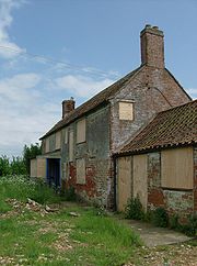 The parish began to take on civil as well as ecclesiastical duties following the 16th century Dissolution of the Monasteries
and the Tudor Poor Law Acts of 1601. The ecclesiastical parish of Navenby was originally placed in the Longoboby Rural Deanery, but was transferred to the Graffoe Rural Deanery in 1968, and it is still part of the Diocese of Lincoln. Navenby officially became a civil parish in the 19th century and became a member of the Lincoln Poor Law Union in 1834. The parish was also part of the Lincoln Rural Sanitary District. The Skinnand civil parish boundaries were adjusted in 1931, to include the civil parish of nearby Navenby.
Following the Local Government Act 1888
, Skinnand was governed by Branston
Rural District Council from 1894–1931. The village then came under the control of North Kesteven
Rural District Council from 1931–1974, after the Local Government Act 1972
reformed the districts of Holland
, Kesteven
and much of Lindsey
into the shire county
of Lincolnshire. Today Skinnand remains part of the North Kesteven district.
Before the 1832 Reform Act, Lincolnshire sent twelve members to parliament, including two for the county, two for the city of Lincoln and two for the boroughs of Boston
, Grantham
, Great Grimsby
and Stamford
. As a result of the act, Lincolnshire's electoral divisions were amended, and Skinnand became part of the South Division Parliamentary District for Lincolnshire
. Two Whig
candidates, Henry Handley and Gilbert John Heathcote
, were returned in the first election. The village remained in the South Division until 1867, when it was transferred to the Mid Division. In 1885 it joined the North Kesteven Division, and in 1918 it became part of the Grantham Division, until 1974.
, known locally as High Dyke. The road runs between the neighbouring villages of Boothby Graffoe
, Navenby and Wellingore
and covers more than 2100 acres (8.5 km²). The Viking Way
, a 147-mile (237 km) footpath between the Humber Bridge
in North Lincolnshire and Oakham
in Rutland
, also passes through the parish.
Skinnand is located at 53°06′25"N 0°35′49"W and is situated just below the ridge of Jurassic
limestone
called the Lincoln Edge or Lincoln Cliff
. The small cliff is one of only a few hills in Lincolnshire. Lying 8.7 miles (14 km) south of Lincoln and 8.9 miles (14.3 km) north-northwest of Sleaford, Skinnand enjoys warm summers and dry frosty winters.
During the Ice Age
, most of the region surrounding Skinnand was covered by ice sheets and this has influenced the topography
and nature of the soils. Much of Lincolnshire is low-lying, in some places below sea level, including Skinnand. The parish of Skinnand and Navenby is elongated in an east–west direction, extending east to the Lincoln Heath and west to the River Brant. The size of the parish has varied over the past two centuries. In 1821 it covered 2110 acres (8.5 km²); in 1951 it was 3345 acres (13.5 km²).
, the British Isles
experience a maritime climate
characterised by relatively cool summers and mild winters. Compared with other parts of the country, Lincolnshire – and Skinnand – are slightly warmer and sunnier in the summer and colder and frostier in the winter. Owing to Skinnand's inland position, far from the landfall of most Atlantic depressions, it is one of the driest places to live in the UK, receiving, on average, less than 3 ft (600 mm) of rain per year. The mean annual daily duration of bright sunshine is four hours and 12 minutes; the absence of any high ground is probably responsible for the area being one of the sunniest parts of the British Isles.
Deserted medieval village
In the United Kingdom, a deserted medieval village is a former settlement which was abandoned during the Middle Ages, typically leaving no trace apart from earthworks or cropmarks. If there are fewer than three inhabited houses the convention is to regard the site as deserted; if there are more...
in Lincolnshire
Lincolnshire
Lincolnshire is a county in the east of England. It borders Norfolk to the south east, Cambridgeshire to the south, Rutland to the south west, Leicestershire and Nottinghamshire to the west, South Yorkshire to the north west, and the East Riding of Yorkshire to the north. It also borders...
. Originally a small farming community situated 9 miles (14 km) south of Lincoln
Lincoln, Lincolnshire
Lincoln is a cathedral city and county town of Lincolnshire, England.The non-metropolitan district of Lincoln has a population of 85,595; the 2001 census gave the entire area of Lincoln a population of 120,779....
and 11.5 miles (19 km) northwest of Sleaford
Sleaford
Sleaford is a town in the North Kesteven district of Lincolnshire, England. It is located thirteen miles northeast of Grantham, seventeen miles west of Boston, and nineteen miles south of Lincoln, and had a total resident population of around 14,500 in 6,167 households at the time...
, it once boasted a church and several houses. It was hit hard, however, by the English Civil War
English Civil War
The English Civil War was a series of armed conflicts and political machinations between Parliamentarians and Royalists...
of 1642-1646, when the church fell into ruins. Today only fields and one deserted farmhouse remain of the once thriving community.
Early history
Archaeological investigations in the area around Skinnand indicate the countryside was occupied from at least the Bronze AgeBronze Age
The Bronze Age is a period characterized by the use of copper and its alloy bronze as the chief hard materials in the manufacture of some implements and weapons. Chronologically, it stands between the Stone Age and Iron Age...
, in about 600 BC. The remains of Iron Age
Iron Age
The Iron Age is the archaeological period generally occurring after the Bronze Age, marked by the prevalent use of iron. The early period of the age is characterized by the widespread use of iron or steel. The adoption of such material coincided with other changes in society, including differing...
farms have been found at nearby Navenby
Navenby
Navenby is a village and civil parish in Lincolnshire, England. Lying south of Lincoln and north-northwest of Sleaford, Navenby has a population of 1,666 and is a dormitory village for Lincoln...
, 2.5 miles (4 km) west of Skinnand, as well as Bronze Age
Bronze Age
The Bronze Age is a period characterized by the use of copper and its alloy bronze as the chief hard materials in the manufacture of some implements and weapons. Chronologically, it stands between the Stone Age and Iron Age...
and Roman
Roman Empire
The Roman Empire was the post-Republican period of the ancient Roman civilization, characterised by an autocratic form of government and large territorial holdings in Europe and around the Mediterranean....
remains. Skinnand was recorded as "Schinende" in the Domesday Book
Domesday Book
Domesday Book , now held at The National Archives, Kew, Richmond upon Thames in South West London, is the record of the great survey of much of England and parts of Wales completed in 1086...
of 1086, a name thought to be of Anglo-Saxon
Anglo-Saxon
Anglo-Saxon may refer to:* Anglo-Saxons, a group that invaded Britain** Old English, their language** Anglo-Saxon England, their history, one of various ships* White Anglo-Saxon Protestant, an ethnicity* Anglo-Saxon economy, modern macroeconomic term...
origin. Historians believe the original name may have come from the Old Scandinavian word "skinnari," which means "skinner or tanner."
Middle Ages
The ancient parish of Skinnand was recorded as the smallest village in the Deanery of Longoboby in 1332. It had the lowest tax assessment, a population of around 40 and was predominantly based around agriculture. The population of Skinnand stayed stable for many generations but, by 1563, only three of the original ten households remained. This decrease in numbers has been attributed, by some historians, to a reduction in arable farming and a rise in sheep production.Records show that the village of Skinnand had up to six houses before the English Civil War, most built as small single-storey stone dwellings with thatched roofs. Two, however, were much larger. One was owned by a John Chester, which boasted four domestic rooms with 'upper chambers,' and the other was the parsonage. The parsonage included a hall, two parlours, a kitchen, buttery, milkhouse, brewhouse and stable. It also had three upstairs rooms, as well as an orchard, garden, yard and dovecote. It is believed the parsonage was pulled down, however, during the Civil War and, by the time of the Hearth Tax returns of 1665, there were just three houses in Skinnand.
Details about the Norman
Norman architecture
About|Romanesque architecture, primarily English|other buildings in Normandy|Architecture of Normandy.File:Durham Cathedral. Nave by James Valentine c.1890.jpg|thumb|200px|The nave of Durham Cathedral demonstrates the characteristic round arched style, though use of shallow pointed arches above the...
-built Anglican church of Skinnand are sketchy, although it was reputedly dedicated to St Matthew and burned down by Oliver Cromwell
Oliver Cromwell
Oliver Cromwell was an English military and political leader who overthrew the English monarchy and temporarily turned England into a republican Commonwealth, and served as Lord Protector of England, Scotland, and Ireland....
's forces in the 1640s. Historical records certainly show that it had begun to fall into ruins in the 17th century - at around the time of the Civil War. The Glebe Terrier documents of 1700 recorded: "The church was in ruins, no house for the rector, more than this we find not, all the buildings being long since disappeared." Despite the disappearance of the church, parish registers reveal that services were still held throughout the 19th century, at the home of Skinnand man John Woolfit. The Skinnand burial ground was also in use until 1911.
19th century
Skinnand was a village of just 12 people in 1801, according to the Census returns. The population did rise slightly over the next 100 years, to 30 in 1901, but by 1921 numbers were once again decreasing and the figure stood at 25. Census returns also reveal that most of the village men worked on the land as unskilled labourers. The children of these poor labourers attended school at WellingoreWellingore
Wellingore is a small rural village in Lincolnshire, approximately south of Lincoln, England on the A607 in the district of North Kesteven. It is just south of Navenby.-History:...
, just south of Navenby, and at Carlton-le-Moorland
Carlton-le-Moorland
Carlton-le-Moorland, is a small village and civil parish in the North Kesteven district of Lincolnshire, England. It lies between Newark on Trent and Lincoln.The nearest adjacent villages are Norton Disney, Brant Broughton and Bassingham....
and Bassingham
Bassingham
Bassingham is a village and civil parish in the North Kesteven district of Lincolnshire, England, with a population of 1308.-Geography:It is about mid-way between Newark-on-Trent and Lincoln. The parish is defined by the River Witham to the west, and the River Brant to the east...
- each village several miles walk away.
As a result of the 1834 Poor Law Amendment Act, the parish became part of the Lincoln Poor Law Union and, by the mid-19th century, Skinnand was a struggling parish
Parish
A parish is a territorial unit historically under the pastoral care and clerical jurisdiction of one parish priest, who might be assisted in his pastoral duties by a curate or curates - also priests but not the parish priest - from a more or less central parish church with its associated organization...
in the Higher division of the wapentake of Boothby Graffoe
Boothby Graffoe
Boothby Graffoe is a village and civil parish in the North Kesteven district of Lincolnshire, England. It lies approximately 7 miles south of Lincoln, on A607 . It's population is approximately 400....
. According to the Institute of Historical Research, it consisted of 636 acres (2.6 km²), of which 40 were arable and the rest "old pasture and meadow." The records add: "The living is a discharged rectory, valued in the King's books at £5. 13. 11½.; net income, £85; patron, S. Nicholls, Esq. The church is in ruins."
Just a few years later, in 1871, it was recorded that "just a few stones remain to mark the location" of the old church. In the same year, the Census showed that the parish now consisted of only three farms, all belonging to Mr S. Nicholls of London
London
London is the capital city of :England and the :United Kingdom, the largest metropolitan area in the United Kingdom, and the largest urban zone in the European Union by most measures. Located on the River Thames, London has been a major settlement for two millennia, its history going back to its...
. Other surnames in the parish at that time included Clawson, Burt and Picker.
20th century
The 1911 Census shows that the population of Skinnand was once again in decline at the turn of the 20th century, with just 28 people living in the village. Most were tenant labourers as, by 1913, William Grant of GrimsbyGrimsby
Grimsby is a seaport on the Humber Estuary in Lincolnshire, England. It has been the administrative centre of the unitary authority area of North East Lincolnshire since 1996...
was the principal landowner. The village was occupied for just a few more years, however, before the final families moved out. Today, just a boarded up old farm house stands where the thriving community of Skinnand once was.
Governance
The parishParish
A parish is a territorial unit historically under the pastoral care and clerical jurisdiction of one parish priest, who might be assisted in his pastoral duties by a curate or curates - also priests but not the parish priest - from a more or less central parish church with its associated organization...
of Skinnand was originally in the higher division of the ancient Boothby Graffoe
Boothby Graffoe
Boothby Graffoe is a village and civil parish in the North Kesteven district of Lincolnshire, England. It lies approximately 7 miles south of Lincoln, on A607 . It's population is approximately 400....
wapentake, in the North Kesteven
North Kesteven
North Kesteven is a local government district in the East Midlands. Just over north of London, it is east of Nottingham and south of Lincoln. North Kesteven is one of seven districts in Lincolnshire, England and is in the centre of the County...
division of the county of Lincolnshire. The term wapentake dates back to the Vikings and was used to describe a collection of local parishes. It originally meant "show your weapon" and the idea behind the term was that all those in favour of a resolution would raise their sword or axe to show agreement.
Skinnand was classed as an ancient parish from the 11th to the 19th century, as it came "under the jurisdiction of a clergyman" and existed before 1597. Early records show that the Manor of Navenby and Skinnand was granted to the Dean and Chapter of Lincoln in 1292. The money generated by land rent was used by Roger de Newton, the first incumbent of the chantry chapel at Harby
Harby, Nottinghamshire
Harby is a village in the English county of Nottinghamshire, the farthest eastern village within the county boundaries. The nearest large town is Lincoln over the border in Lincolnshire. According to the 2001 census it had a population of 289. The parish church of All Saints was built in 1875-76 in...
, Nottinghamshire
Nottinghamshire
Nottinghamshire is a county in the East Midlands of England, bordering South Yorkshire to the north-west, Lincolnshire to the east, Leicestershire to the south, and Derbyshire to the west...
, to maintain the building. This followed the death of Queen Eleanor
Eleanor of Castile
Eleanor of Castile was the first queen consort of Edward I of England. She was also Countess of Ponthieu in her own right from 1279 until her death in 1290, succeeding her mother and ruling together with her husband.-Birth:...
, wife of Edward I
Edward I of England
Edward I , also known as Edward Longshanks and the Hammer of the Scots, was King of England from 1272 to 1307. The first son of Henry III, Edward was involved early in the political intrigues of his father's reign, which included an outright rebellion by the English barons...
, while on a visit to Lincoln. Eleanor died at de Newton's manor house at Harby in November 1290 and the chapel was erected in her honour.
Dissolution of the Monasteries
The Dissolution of the Monasteries, sometimes referred to as the Suppression of the Monasteries, was the set of administrative and legal processes between 1536 and 1541 by which Henry VIII disbanded monasteries, priories, convents and friaries in England, Wales and Ireland; appropriated their...
and the Tudor Poor Law Acts of 1601. The ecclesiastical parish of Navenby was originally placed in the Longoboby Rural Deanery, but was transferred to the Graffoe Rural Deanery in 1968, and it is still part of the Diocese of Lincoln. Navenby officially became a civil parish in the 19th century and became a member of the Lincoln Poor Law Union in 1834. The parish was also part of the Lincoln Rural Sanitary District. The Skinnand civil parish boundaries were adjusted in 1931, to include the civil parish of nearby Navenby.
Following the Local Government Act 1888
Local Government Act 1888
The Local Government Act 1888 was an Act of the Parliament of the United Kingdom, which established county councils and county borough councils in England and Wales...
, Skinnand was governed by Branston
Branston, Lincolnshire
Branston is a large village in the North Kesteven district of Lincolnshire, England, approximately south-east of Lincoln.In the 2001 Census the population was recorded as 4019.-Geography:...
Rural District Council from 1894–1931. The village then came under the control of North Kesteven
North Kesteven
North Kesteven is a local government district in the East Midlands. Just over north of London, it is east of Nottingham and south of Lincoln. North Kesteven is one of seven districts in Lincolnshire, England and is in the centre of the County...
Rural District Council from 1931–1974, after the Local Government Act 1972
Local Government Act 1972
The Local Government Act 1972 is an Act of Parliament in the United Kingdom that reformed local government in England and Wales on 1 April 1974....
reformed the districts of Holland
Holland, Lincolnshire
Holland is an area of south-east Lincolnshire, England. The name is still recognised locally and survives in the district of South Holland.-Administration:...
, Kesteven
Kesteven
The Parts of Kesteven are a traditional subdivision of Lincolnshire, England. This subdivision had long had a separate county administration , along with the other two parts, Lindsey and Holland.-Etymology:...
and much of Lindsey
Lindsey
Lindsey was a unit of local government until 1974 in Lincolnshire, England, covering the northern part of the county. The Isle of Axholme, which is on the west side of the River Trent, has normally formed part of it...
into the shire county
Shire county
A non-metropolitan county, or shire county, is a county-level entity in England that is not a metropolitan county. The counties typically have populations of 300,000 to 1.4 million. The term shire county is, however, an unofficial usage. Many of the non-metropolitan counties bear historic names...
of Lincolnshire. Today Skinnand remains part of the North Kesteven district.
Before the 1832 Reform Act, Lincolnshire sent twelve members to parliament, including two for the county, two for the city of Lincoln and two for the boroughs of Boston
Boston, Lincolnshire
Boston is a town and small port in Lincolnshire, on the east coast of England. It is the largest town of the wider Borough of Boston local government district and had a total population of 55,750 at the 2001 census...
, Grantham
Grantham
Grantham is a market town within the South Kesteven district of Lincolnshire, England. It bestrides the East Coast Main Line railway , the historic A1 main north-south road, and the River Witham. Grantham is located approximately south of the city of Lincoln, and approximately east of Nottingham...
, Great Grimsby
Grimsby
Grimsby is a seaport on the Humber Estuary in Lincolnshire, England. It has been the administrative centre of the unitary authority area of North East Lincolnshire since 1996...
and Stamford
Stamford, Lincolnshire
Stamford is a town and civil parish within the South Kesteven district of the county of Lincolnshire, England. It is approximately to the north of London, on the east side of the A1 road to York and Edinburgh and on the River Welland...
. As a result of the act, Lincolnshire's electoral divisions were amended, and Skinnand became part of the South Division Parliamentary District for Lincolnshire
South Lincolnshire (UK Parliament constituency)
South Lincolnshire, formally called the Southern Division of Lincolnshire or Parts of Kesteven and Holland, was a county constituency in Lincolnshire...
. Two Whig
British Whig Party
The Whigs were a party in the Parliament of England, Parliament of Great Britain, and Parliament of the United Kingdom, who contested power with the rival Tories from the 1680s to the 1850s. The Whigs' origin lay in constitutional monarchism and opposition to absolute rule...
candidates, Henry Handley and Gilbert John Heathcote
Gilbert Heathcote, 1st Baron Aveland
Gilbert John Heathcote, 1st Baron Aveland , known as Sir Gilbert John Heathcote, 5th Baronet, from 1851 to 1856, was a British peer and Whig politician.-Background:...
, were returned in the first election. The village remained in the South Division until 1867, when it was transferred to the Mid Division. In 1885 it joined the North Kesteven Division, and in 1918 it became part of the Grantham Division, until 1974.
Geography
The civil parish of Skinnand lies close to the old Roman Ermine StreetErmine Street
Ermine Street is the name of a major Roman road in England that ran from London to Lincoln and York . The Old English name was 'Earninga Straete' , named after a tribe called the Earningas, who inhabited a district later known as Armingford Hundred, around Arrington, Cambridgeshire and Royston,...
, known locally as High Dyke. The road runs between the neighbouring villages of Boothby Graffoe
Boothby Graffoe
Boothby Graffoe is a village and civil parish in the North Kesteven district of Lincolnshire, England. It lies approximately 7 miles south of Lincoln, on A607 . It's population is approximately 400....
, Navenby and Wellingore
Wellingore
Wellingore is a small rural village in Lincolnshire, approximately south of Lincoln, England on the A607 in the district of North Kesteven. It is just south of Navenby.-History:...
and covers more than 2100 acres (8.5 km²). The Viking Way
Viking Way
The Viking Way is a long distance footpath in England running between the Humber Bridge in North Lincolnshire and Oakham in Rutland. The Countryside Commission recognised the significance of the Viking Way as a high quality long distance walk linking other major routes in Eastern England, these...
, a 147-mile (237 km) footpath between the Humber Bridge
Humber Bridge
The Humber Bridge, near Kingston upon Hull, England, is a 2,220 m single-span suspension bridge, which opened to traffic on 24 June 1981. It is the fifth-largest of its type in the world...
in North Lincolnshire and Oakham
Oakham
-Oakham's horseshoes:Traditionally, members of royalty and peers of the realm who visited or passed through the town had to pay a forfeit in the form of a horseshoe...
in Rutland
Rutland
Rutland is a landlocked county in central England, bounded on the west and north by Leicestershire, northeast by Lincolnshire and southeast by Peterborough and Northamptonshire....
, also passes through the parish.
Skinnand is located at 53°06′25"N 0°35′49"W and is situated just below the ridge of Jurassic
Jurassic
The Jurassic is a geologic period and system that extends from about Mya to Mya, that is, from the end of the Triassic to the beginning of the Cretaceous. The Jurassic constitutes the middle period of the Mesozoic era, also known as the age of reptiles. The start of the period is marked by...
limestone
Limestone
Limestone is a sedimentary rock composed largely of the minerals calcite and aragonite, which are different crystal forms of calcium carbonate . Many limestones are composed from skeletal fragments of marine organisms such as coral or foraminifera....
called the Lincoln Edge or Lincoln Cliff
Lincoln Cliff
The Lincoln Cliff is the portion of a major escarpment that runs north-south through Lindsey and Kesteven, in central Lincolnshire and is a prominent landscape feature in a generally flat portion of the county...
. The small cliff is one of only a few hills in Lincolnshire. Lying 8.7 miles (14 km) south of Lincoln and 8.9 miles (14.3 km) north-northwest of Sleaford, Skinnand enjoys warm summers and dry frosty winters.
During the Ice Age
Ice age
An ice age or, more precisely, glacial age, is a generic geological period of long-term reduction in the temperature of the Earth's surface and atmosphere, resulting in the presence or expansion of continental ice sheets, polar ice sheets and alpine glaciers...
, most of the region surrounding Skinnand was covered by ice sheets and this has influenced the topography
Topography
Topography is the study of Earth's surface shape and features or those ofplanets, moons, and asteroids...
and nature of the soils. Much of Lincolnshire is low-lying, in some places below sea level, including Skinnand. The parish of Skinnand and Navenby is elongated in an east–west direction, extending east to the Lincoln Heath and west to the River Brant. The size of the parish has varied over the past two centuries. In 1821 it covered 2110 acres (8.5 km²); in 1951 it was 3345 acres (13.5 km²).
Climate
According to the Köppen classificationKöppen climate classification
The Köppen climate classification is one of the most widely used climate classification systems. It was first published by Crimea German climatologist Wladimir Köppen in 1884, with several later modifications by Köppen himself, notably in 1918 and 1936...
, the British Isles
British Isles
The British Isles are a group of islands off the northwest coast of continental Europe that include the islands of Great Britain and Ireland and over six thousand smaller isles. There are two sovereign states located on the islands: the United Kingdom of Great Britain and Northern Ireland and...
experience a maritime climate
Oceanic climate
An oceanic climate, also called marine west coast climate, maritime climate, Cascadian climate and British climate for Köppen climate classification Cfb and subtropical highland for Köppen Cfb or Cwb, is a type of climate typically found along the west coasts at the middle latitudes of some of the...
characterised by relatively cool summers and mild winters. Compared with other parts of the country, Lincolnshire – and Skinnand – are slightly warmer and sunnier in the summer and colder and frostier in the winter. Owing to Skinnand's inland position, far from the landfall of most Atlantic depressions, it is one of the driest places to live in the UK, receiving, on average, less than 3 ft (600 mm) of rain per year. The mean annual daily duration of bright sunshine is four hours and 12 minutes; the absence of any high ground is probably responsible for the area being one of the sunniest parts of the British Isles.
External links
- Rectors of Skinnand, and other clerical appointments 1749–1822 as recorded in the Clergy of the Church of England DatabaseClergy of the Church of England databaseThe Clergy of the Church of England database is an online database of clergy of the Church of England between 1540 and 1835.The database project began in 1999 with funding from the Arts and Humanities Research Council, and is ongoing as a collaboration between King's College London, the University...
. Retrieved 2008-06-02.
- David Merchant (2011). Historical notes and images concerning the medieval village of Skinnand as recorded on the website www.skinnand.co.uk/