

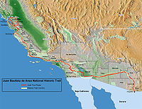
Juan Bautista de Anza National Historic Trail
Encyclopedia
National Park Service
The National Park Service is the U.S. federal agency that manages all national parks, many national monuments, and other conservation and historical properties with various title designations...
unit in the United States
United States
The United States of America is a federal constitutional republic comprising fifty states and a federal district...
National Historic Trail
National Historic Trail
National Historic Trail is a designation for a protected area in the United States containing historic trails and surrounding areas. They are part of the National Trails System....
and National Millennium Trail
National Millennium Trail
National Millennium Trails are 16 long-distance trails selected from 58 nominees as visionary trails that reflect defining aspects America's history and culture...
programs. The trail route extends from Nogales
Nogales, Arizona
Nogales is a city in Santa Cruz County, Arizona, United States. The population was 21,017 at the 2010 census. According to 2005 Census Bureau estimates, the population of the city is 20,833. The city is the county seat of Santa Cruz County....
on the U.S.-Mexico border in Arizona
Arizona
Arizona ; is a state located in the southwestern region of the United States. It is also part of the western United States and the mountain west. The capital and largest city is Phoenix...
, through the California desert and coastal areas in Southern California
Southern California
Southern California is a megaregion, or megapolitan area, in the southern area of the U.S. state of California. Large urban areas include Greater Los Angeles and Greater San Diego. The urban area stretches along the coast from Ventura through the Southland and Inland Empire to San Diego...
and the Central Coast region
Central Coast of California
The Central Coast is an area of California, United States, roughly spanning the area between the Monterey Bay and Point Conception. It extends through Santa Cruz County, San Benito County, Monterey County, San Luis Obispo County, and Santa Barbara County...
to San Francisco
San Francisco, California
San Francisco , officially the City and County of San Francisco, is the financial, cultural, and transportation center of the San Francisco Bay Area, a region of 7.15 million people which includes San Jose and Oakland...
.
History
Juan Bautista de Anza
Juan Bautista de Anza
Juan Bautista de Anza Bezerra Nieto was a Novo-Spanish explorer and Governor of New Mexico for the Spanish Empire.-Early life:...
leading an exploratory expedition on January 8, 1774, with 3 padres, 20 soldiers, 11 servants, 35 mules, 65 cattle, and 140 horses set forth from Tubac
Tubac, Arizona
Tubac is a census-designated place in Santa Cruz County, Arizona, United States. The population was 949 at the 2000 census. The place name Tubac is an English borrowing from a Hispanicized form of the O'odham name, which translates into English as "rotten". The original O'odham name is written...
south of present day Tucson, Arizona
Tucson, Arizona
Tucson is a city in and the county seat of Pima County, Arizona, United States. The city is located 118 miles southeast of Phoenix and 60 miles north of the U.S.-Mexico border. The 2010 United States Census puts the city's population at 520,116 with a metropolitan area population at 1,020,200...
. They went across the Sonoran desert to California from Mexico by swinging south of the Gila River
Gila River
The Gila River is a tributary of the Colorado River, 650 miles long, in the southwestern states of New Mexico and Arizona.-Description:...
to avoid Apache
Apache
Apache is the collective term for several culturally related groups of Native Americans in the United States originally from the Southwest United States. These indigenous peoples of North America speak a Southern Athabaskan language, which is related linguistically to the languages of Athabaskan...
attacks until they hit the Colorado River
Colorado River
The Colorado River , is a river in the Southwestern United States and northwestern Mexico, approximately long, draining a part of the arid regions on the western slope of the Rocky Mountains. The watershed of the Colorado River covers in parts of seven U.S. states and two Mexican states...
at the Yuma Crossing
Yuma Crossing
Yuma Crossing is a site in Arizona and California that is significant for its association with transportation and communication across the Colorado River. It connected New Spain and Las Californias in the Spanish Colonial period in and also during the Western expansion of the United States. ...
—about the only way across the Colorado River. The friendly Quechan
Quechan
The Quechan are a Native American tribe who live on the Fort Yuma Indian Reservation on the lower Colorado River in Arizona and California just north of the border with Mexico...
(Yuma) Indians (2-3,000) they encountered there were growing most of their food using irrigation systems and had already imported pottery, horses, wheat and a few other crops from New Mexico
New Mexico
New Mexico is a state located in the southwest and western regions of the United States. New Mexico is also usually considered one of the Mountain States. With a population density of 16 per square mile, New Mexico is the sixth-most sparsely inhabited U.S...
. After crossing the Colorado to avoid the impassible Algodones Dunes
Algodones Dunes
The Algodones Dunes is a large erg located in the southeastern portion of the U.S. state of California, near the border with Arizona and the Mexican state of Baja California. The field is approximately 45 miles long by 6 miles wide and extends along a northwest-southeast line that correlates to...
, they followed the river about 50 miles (80.5 km) south to approximately Arizona’s southwest corner on the Colorado River before turning northwest near present-day Mexicali, Mexico and then turned north through present-day Imperial Valley
Imperial Valley
The Imperial Valley is an agricultural area of Southern California's Imperial County. It is located in southeastern Southern California, centered around the city of El Centro. Locally, the terms "Imperial Valley" and "Imperial County" are used synonymously. The Valley is bordered between the...
and then northwest again before reaching Mission San Gabriel Arcángel
Mission San Gabriel Arcángel
The Mission San Gabriel Arcángel is a fully functioning Roman Catholic mission and a historic landmark in San Gabriel, California. The settlement was founded by Spaniards of the Franciscan order on "The Feast of the Birth of Mary," September 8, 1771, as the fourth of what would become 21 Spanish...
near the future city of Los Angeles, California
Los Angeles, California
Los Angeles , with a population at the 2010 United States Census of 3,792,621, is the most populous city in California, USA and the second most populous in the United States, after New York City. It has an area of , and is located in Southern California...
. The Pueblo de Los Angeles
Pueblo de Los Angeles
El Pueblo de Nuestra Señora la Reina de los Ángeles was the Spanish civilian pueblo founded in 1781, which by the 20th century became the American metropolis of Los Angeles....
would be established in 1781 by eleven families recruited mostly from Sonora y Sinaloa Province. It took Anza about 74 days to do this initial reconnaissance trip to establish a land route into California. On his return trip he retraced his path to the Yuma Crossing of the Colorado River
Colorado River
The Colorado River , is a river in the Southwestern United States and northwestern Mexico, approximately long, draining a part of the arid regions on the western slope of the Rocky Mountains. The watershed of the Colorado River covers in parts of seven U.S. states and two Mexican states...
and then went down the Gila River
Gila River
The Gila River is a tributary of the Colorado River, 650 miles long, in the southwestern states of New Mexico and Arizona.-Description:...
corridor until hitting the Santa Cruz River (Arizona) corridor and continuing on to Tubac, Arizona
Tubac, Arizona
Tubac is a census-designated place in Santa Cruz County, Arizona, United States. The population was 949 at the 2000 census. The place name Tubac is an English borrowing from a Hispanicized form of the O'odham name, which translates into English as "rotten". The original O'odham name is written...
. The return trip only took 23 days as he now had found a trail with sufficient water to make land access to California possible. On the Gila river he encountered several extensive villages of Pima (Akimel O'odham) Indians. These were a peaceful and populous agricultural tribe with extensive crops and irrigation systems located along the Gila River.
In Anza’s second trip (1775-1776) he returned to California via the Gila River path he had discovered with 240 Frairs, soldiers and colonists with their families. They took 695 horses and mules, 385 Texas Longhorn
Texas longhorn (cattle)
The Texas Longhorn is a breed of cattle known for its characteristic horns, which can extend to tip to tip for steers and exceptional cows, and tip to tip for bulls. Horns can have a slight upward turn at their tips or even triple twist. Texas Longhorns are known for their diverse coloring...
bulls and cows with them —starting the cattle and horse industry in California. In California the cattle and horses had few enemies and plentiful grass in all but drought years and essentially grew and multiplied as feral animals--doubling roughly every two years. They started from Tubac Arizona on October 22, 1775 and arrived at San Francisco Bay
San Francisco Bay
San Francisco Bay is a shallow, productive estuary through which water draining from approximately forty percent of California, flowing in the Sacramento and San Joaquin rivers from the Sierra Nevada mountains, enters the Pacific Ocean...
on March 28, 1776. There they established the Presidio of San Francisco
Presidio of San Francisco
The Presidio of San Francisco is a park on the northern tip of the San Francisco Peninsula in San Francisco, California, within the Golden Gate National Recreation Area...
, followed by Mission San Francisco de Asís
Mission San Francisco de Asís
Mission San Francisco de Asís, or Mission Dolores, is the oldest surviving structure in San Francisco and the sixth religious settlement established as part of the California chain of missions...
(Mission Dolores) – the future city of San Francisco, California
San Francisco, California
San Francisco , officially the City and County of San Francisco, is the financial, cultural, and transportation center of the San Francisco Bay Area, a region of 7.15 million people which includes San Jose and Oakland...
In 1779 Father Francisco Garcés
Francisco Garcés
Francisco Hermenegildo Tomás Garcés was a Spanish Franciscan missionary who explored much of the southwestern part of North America, including what are now Arizona, southern California, and northeastern Baja California. Garcés was born April 12, 1738, in Morata de Jalón , Zaragoza province,...
was assigned to establish a mission at Yuma crossing of the Colorado River
Colorado River
The Colorado River , is a river in the Southwestern United States and northwestern Mexico, approximately long, draining a part of the arid regions on the western slope of the Rocky Mountains. The watershed of the Colorado River covers in parts of seven U.S. states and two Mexican states...
. In 1780 the Spanish established two combination missions and pueblos at the Yuma Colorado River Crossing of the Anza trail: Mission San Pedro y San Pablo de Bicuñer
Mission San Pedro y San Pablo de Bicuñer
Mission San Pedro y San Pablo de Bicuñer was founded on January 7, 1781 by Father Francisco Garcés to protect the Anza Trail where it forded the Colorado River....
and Mission Puerto de Purísima Concepción
Mission Puerto de Purísima Concepción
Mission Puerto de Purísima Concepción was founded in October, 1780, by Father Francisco Garcés. The settlement was not part of the California mission chain, but was administered as a part of the Arizona missions...
. Both these pueblos and missions were on the California side of the Colorado River near the mouth of the Gila River
Gila River
The Gila River is a tributary of the Colorado River, 650 miles long, in the southwestern states of New Mexico and Arizona.-Description:...
but were administered by the Arizona authorities.
The settlement of Los Angeles, California involved two groups totaling 44 persons including 22 children. One group under Alfèrez Ramon Laso de la Vega crossed the Gulf of California
Gulf of California
The Gulf of California is a body of water that separates the Baja California Peninsula from the Mexican mainland...
on launches and then travelled overland to San Diego and up to the San Gabriel Mission
The second group, under Fernando Rivera y Moncada
Fernando Rivera y Moncada
Fernando Javier Rivera y Moncada was a soldier from New Spain who served in the Baja California peninsula and upper Las Californias, participating in several early overland explorations. Fernando Rivera y Moncada served as a Spanish Miilitary Governor from 1774-1777. -Biography:Rivera was born...
, took an overland route over the Anza trail 1200 miles (1,931.2 km) through the desert from Sinaloa
Sinaloa
Sinaloa officially Estado Libre y Soberano de Sinaloa is one of the 31 states which, with the Federal District, comprise the 32 Federal Entities of Mexico. It is divided in 18 municipalities and its capital city is Culiacán Rosales....
Mexico. They passed through the new missions on the Colorado River, La Purísima Concepción
La Purísima Concepción
La Purísima Concepción may refer to one of several Spanish missions, including the following:United States* Mission La Purísima Concepción in Lompoc, California* Rancho La Purísima Concepción in Los Altos Hills, California...
and Mission San Pedro y San Pablo de Bicuñer
Mission San Pedro y San Pablo de Bicuñer
Mission San Pedro y San Pablo de Bicuñer was founded on January 7, 1781 by Father Francisco Garcés to protect the Anza Trail where it forded the Colorado River....
. The group arrived at the Colorado River in June 1781. Rivera y Moncada sent most of his party ahead, but he stayed behind to rest the livestock before continuing their drive across the desert. His party would never reach San Gabriel. In July Rivera was killed along with the local missionaries, settlers, and travelers with the revolt of the Quechan Indians (Yuma Revolt) in 1781.
The Quechan
Quechan
The Quechan are a Native American tribe who live on the Fort Yuma Indian Reservation on the lower Colorado River in Arizona and California just north of the border with Mexico...
and Mojave Indians rose up against the party for encroaching on their farmlands and for other abuses inflicted by the soldiers. On 17-19 July 1781 the Yuma (Quechan
Quechan
The Quechan are a Native American tribe who live on the Fort Yuma Indian Reservation on the lower Colorado River in Arizona and California just north of the border with Mexico...
) Indians, in a dispute with the New Spain government and church, destroyed both missions and pueblos--killing 103 soldiers, colonists and Frairs and capturing about 80 more--mostly women and children. Included in the casualties were Fernando Rivera y Moncada
Fernando Rivera y Moncada
Fernando Javier Rivera y Moncada was a soldier from New Spain who served in the Baja California peninsula and upper Las Californias, participating in several early overland explorations. Fernando Rivera y Moncada served as a Spanish Miilitary Governor from 1774-1777. -Biography:Rivera was born...
military commander and former governor of California and Father Francisco Garcés
Francisco Garcés
Francisco Hermenegildo Tomás Garcés was a Spanish Franciscan missionary who explored much of the southwestern part of North America, including what are now Arizona, southern California, and northeastern Baja California. Garcés was born April 12, 1738, in Morata de Jalón , Zaragoza province,...
founder of the missions on the Colorado River. In four well supported punitive expeditions in 1782 and 1783 against the Quechans the Spanish managed to gather their dead and ransom nearly all the prisoners; but failed to re-open the Anza Trail. The Yuma Crossing
Yuma Crossing
Yuma Crossing is a site in Arizona and California that is significant for its association with transportation and communication across the Colorado River. It connected New Spain and Las Californias in the Spanish Colonial period in and also during the Western expansion of the United States. ...
and the Anza trail were closed for Spanish traffic and it would stay closed till about 1846. California was nearly isolated again from land based travel. About the only way into California from Mexico would now be a 40-60 day voyage by sea. According to historian David Weber, the Yuma revolt turned California into an "island" and Arizona into a "cul de sac", severing Arizona-California and Mexican land connections before they could be firmly established.
The Trail commemorates the 1775–1776 land route that Spanish
Spain
Spain , officially the Kingdom of Spain languages]] under the European Charter for Regional or Minority Languages. In each of these, Spain's official name is as follows:;;;;;;), is a country and member state of the European Union located in southwestern Europe on the Iberian Peninsula...
commander Juan Bautista de Anza
Juan Bautista de Anza
Juan Bautista de Anza Bezerra Nieto was a Novo-Spanish explorer and Governor of New Mexico for the Spanish Empire.-Early life:...
took from the Sonora y Sinaloa
Sonora y Sinaloa
Sonora y Sinaloa was a province in the Provincias Internas and under the jurisdiction of the Real Audiencia of Guadalajara of Viceroyalty of New Spain. After Independence Sonora y Sinaloa became one of the constituent states of the Mexican Republic...
Province of New Spain
New Spain
New Spain, formally called the Viceroyalty of New Spain , was a viceroyalty of the Spanish colonial empire, comprising primarily territories in what was known then as 'América Septentrional' or North America. Its capital was Mexico City, formerly Tenochtitlan, capital of the Aztec Empire...
in Colonial Mexico through to the Las Californias
Las Californias
The Californias, or in — - was the name given by the Spanish to their northwestern territory of New Spain, comprising the present day states of Baja California and Baja California Sur on the Baja California Peninsula in Mexico; and the present day U.S. state of California in the United States of...
Province. The goal of the 1775-1776 trip was to establish a mission and presidio on the San Francisco Bay
San Francisco Bay Area
The San Francisco Bay Area, commonly known as the Bay Area, is a populated region that surrounds the San Francisco and San Pablo estuaries in Northern California. The region encompasses metropolitan areas of San Francisco, Oakland, and San Jose, along with smaller urban and rural areas...
. The trail was an attempt to ease the course of Spanish colonization of California by establishing a major land route north for many to follow. It was used for about five years before being closed by the Quechan
Quechan
The Quechan are a Native American tribe who live on the Fort Yuma Indian Reservation on the lower Colorado River in Arizona and California just north of the border with Mexico...
(Yuma) Indians in 1781 and kept closed for the next 40 years and longer.
Modern touring
Along the Juan Bautista de Anza National Historic Trail route, visitors can experience the varied landscapes similar to those the expedition saw; learn the stories of the expedition's events, members, and descendants; better understand the Native AmericanNative Americans in the United States
Native Americans in the United States are the indigenous peoples in North America within the boundaries of the present-day continental United States, parts of Alaska, and the island state of Hawaii. They are composed of numerous, distinct tribes, states, and ethnic groups, many of which survive as...
diversity of cultures in their homelands and their guidance on the expedition; and appreciate the extent and lasting influences of Spanish colonial settlements in present day Arizona
Arizona
Arizona ; is a state located in the southwestern region of the United States. It is also part of the western United States and the mountain west. The capital and largest city is Phoenix...
and California
California
California is a state located on the West Coast of the United States. It is by far the most populous U.S. state, and the third-largest by land area...
. The Trail was designated a National Historic Trail
National Historic Trail
National Historic Trail is a designation for a protected area in the United States containing historic trails and surrounding areas. They are part of the National Trails System....
in 1990 and a National Millennium Trail
National Millennium Trail
National Millennium Trails are 16 long-distance trails selected from 58 nominees as visionary trails that reflect defining aspects America's history and culture...
in 1999.
In 2005, Caltrans began posting signs on roads that overlap with the trail route, so that California drivers can now follow the trail.
Designated sights
The National Park ServiceNational Park Service
The National Park Service is the U.S. federal agency that manages all national parks, many national monuments, and other conservation and historical properties with various title designations...
has developed a printed and online: Brochure Map for driving and guides for auto tours, hiking sections, and designated Historic sights, landmarks, and museums open to the public. Schedules of Anza celebrations and other historic events are on an updated NPS: What to Do-Events Guide. The detailed Anza Trail Maps by County show more points of interest, trailheads, and local lore.
Growing
The Juan Bautista de Anza National Historic Trail "project" is ever growing as local, state, and NPS efforts establish more trails, signage, and interpretive programs. The Trail is inspiring activities at existing municipal parks, neighborhood greenbelts, regional parkRegional park
Regional park is a term used for an area of land preserved on account of its natural beauty, historic interest, recreational use or other reason, and under the administration of a form of local government.-Definition:...
s, and large open space preserves. The ever changing opportunities can be discovered and tracked at the official Juan Bautista de Anza National Historic Trail website.
See also
- Category: California explorers
- Las CaliforniasLas CaliforniasThe Californias, or in — - was the name given by the Spanish to their northwestern territory of New Spain, comprising the present day states of Baja California and Baja California Sur on the Baja California Peninsula in Mexico; and the present day U.S. state of California in the United States of...
- 1786 - 1804 - Alta CaliforniaAlta CaliforniaAlta California was a province and territory in the Viceroyalty of New Spain and later a territory and department in independent Mexico. The territory was created in 1769 out of the northern part of the former province of Las Californias, and consisted of the modern American states of California,...
- 1804 - 1848 - Spanish missions in CaliforniaSpanish missions in CaliforniaThe Spanish missions in California comprise a series of religious and military outposts established by Spanish Catholics of the Franciscan Order between 1769 and 1823 to spread the Christian faith among the local Native Americans. The missions represented the first major effort by Europeans to...
- History of California to 1899History of California to 1899Human history in California begins with indigenous Americans first arriving in California some 13,000-15,000 years ago. Exploration and settlement by Europeans along the coasts and in the inland valleys began in the 16th century...
- Spanish period of ArizonaSpanish period of ArizonaIn the late 18th century, colonists began steadily entering the region of northern New Spain that is the modern-day U.S. state of Arizona. They were attracted by reports of the discovery of deposits of silver around the Arizonac mining camp...
- Spanish missions in the Sonoran DesertSpanish missions in the Sonoran DesertThe Spanish missions in the Sonoran Desert are a series of Jesuit Catholic religious outposts established by the Spanish Catholic Jesuits and other orders for religious conversions of the Pima and Tohono O'odham indigenous peoples residing in the Sonoran Desert...
- Mexican period of ArizonaMexican period of ArizonaIn 1821, Mexico won its independence from Spain after a decade of war. The revolution had destroyed the colonial silver mining industry and had bankrupted the national treasury. Along the northern frontier, funds that had supported missions, presidios and trading routes were reduced. As missions...