

Sierra Vista, Arizona
Encyclopedia
Sierra Vista is a city in Cochise County, Arizona
, United States. According to 2007 Census Bureau estimates, the population of the city is 43,044.
The city is part of the Sierra Vista-Douglas Micropolitan Area with an estimated population of 129,518. Fort Huachuca
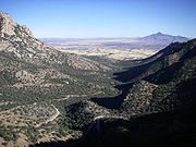
, a U.S. Army post, is included in City population estimates and is located in the northwest part of the city. Sierra Vista, which is Spanish for "Mountain View", is located 70 miles (112.7 km) southeast of Tucson and serves as the main commercial, cultural, and recreational hub of Cochise County. The city is accessible via Interstate 10
and State Highway 90. The city is surrounded by the Huachuca Mountains
, Dragoon Mountains
, Whetstone Mountains
, Mustang Mountains, and Mule Mountains
and is bordered on the east by the San Pedro River
.
, the protection of Fort Huachuca
and the completion of the Southern Pacific and the El Paso & Southwestern
railroads, the San Pedro Valley
began to populate. Oliver Fry and his two oldest sons traveled from Texas
on the railroad and settled on 320 acres (1.3 km²) just outside of Fort Huachuca around 1901.
The first business that opened just outside the east gate of Fort Huachuca was a saloon and house of ill repute owned by John and Ellen Reilly opened in 1892. In 1911, Margaret Carmichael bought the Reilly homestead and business. By 1913, Margaret Carmichael had leased the business back to the Reillys. Also in 1913, a group of dry land farmers settled in the local area and named their settlement Buena. Buena was located east of Garden Canyon on a railroad whistle-stop between Lewis Springs and Fort Huachuca. At this site was a post office and a school house that served children in Buena, Garden Canyon and outreaches of the local area.
By 1917, the Overton Post Office was established. This settlement's name comes from the Overton Mercantile and Investment Company, who took option on the Carmichael property with plans to develop a townsite outside of Fort Huachuca. However, it is believed that the company was unable to persuade anyone to move to the area so when the option expired, the Carmichaels took back the property and a general mercantile store.
In 1918, the Carmichaels changed the name of the store and were the proprietors of the "Garden Canyon." Garden Canyon was also the name of the post office and Carmichael was the postmaster. In addition, the Carmichaels built a home across the street from Garden Canyon store, as well as 18 rock houses, on Garden Avenue. From 1927 to 1938, the Frys rented the Carmichael store.
In 1955, the first attempt to incorporate and rename the area was rejected, as Fry opposed both incorporating and renaming the town that bore his family name. In 1956, the ballot issue failed 76 to 61. People who owned land outside of Fry's property went forward with incorporation and renaming by petition on May 26, 1956, excluding the half-square-mile owned by Fry.
Sierra Vista was incorporated in 1956, and has an estimated population over 49,000 today. The city is the economic and commercial center of Cochise County, and northern Sonora
, Mexico. Sierra Vista annexed Fort Huachuca, a U.S. military base, one of the largest employers in Arizona, and the adjacent community, in 1971.
According to the United States Census Bureau
, the city has a total area of 153.5 square miles (397.6 km²), of which 153.5 square miles (397.6 km²) is land and 0.04 square mile (0.1035995244 km²) is water. It is located 4623 feet (1,409.1 m) above sea level. Sierra Vista is flanked on the west side by the Huachuca Mountains with Miller Peak rising to 9,466 ft (2,885.2 m) and Carr Peak
at 9,236 ft (2,815.1 m).
system. The city has a fairly stable climate with very little humidity. However, the North American Monsoon
can bring torrential rain during the months of July and August and will produce almost half the yearly rainfall in just those two months alone. Due to the dry climate the rest of the year and the city's high elevation, daily high and low temperatures range 20 to 30 degrees F (11.1 to 16.7 degrees C) on average and up to 50 degrees F (27.8 degrees C) on rare occasions. Snow is not a common sight on the streets of Sierra Vista though some years the city can receive several inches of snow and other years it will receive none. However, a snow capped Miller Peak and Carr Peak
in the Huachuca Mountains
is a common sight for 4 – 5 months every year.
 Nicknamed the "Hummingbird Capital of the United States", bird watchers from all over the world flock to the nearby Ramsey Canyon Preserve and other local canyons to observe and photograph hundreds of different bird species. Other outdoor sightseeing and recreational opportunities that are nearby include the San Pedro Riparian National Conservation Area
, the Coronado National Memorial
in the Huachuca Mountains
, Cochise Stronghold in the Dragoon Mountains
, Chiricahua National Monument
, Madera Canyon
, Kartchner Caverns State Park
, Parker Canyon Lake
, and Patagonia Lake State Park
. Excellent views of the clear night sky have led Sierra Vista to become the chosen center of amateur astronomy in Arizona with more than a dozen well equipped amateur observatories in the area and a large observatory at the University of Arizona South
within the city limits.
Also indicated in the CER 2009 Economic Outlook publication, the Arizona DEC estimates the Sierra Vista Area size is approximately 75,000, which includes outlying areas of Sierra Vista Southeast Census Designated Place (CDP), Huachuca City, Tombstone
, Whetstone
, Hereford
and unincorporated surrounding areas. The population of the Sierra Vista Area is estimated to reach nearly 100,000 by 2028.
According to Census 2000 figures, the Sierra Vista population consists of 14,196 households, and 9,993 families residing in the city. The population density was 246.1 people per square mile (95.0/km²). There were 15,685 housing units at an average density of 102.2 per square mile (39.5/km²). The racial makeup of the city was 73.34% White
, 10.89% Black
or African American
, 3.57% Asian
, 0.83% Native American
and 0.46% Pacific Islander
. 6.05% of the population is from other races
, and 4.86% from two or more races. 15.8% of the population is Hispanic
or Latino
.
There were 14,196 households out of which 34.9% had children under the age of 18 living with them, 56.5% were married couples living together, 25.1% of all households were made up of individuals and 7.7% had someone living alone who was 65 years of age or older. The average household size was 2.48 and the average family size was 2.96.
In the city the age distribution of the population shows 25.8% under the age of 18, 13.0% from 18 to 24, 29.2% from 25 to 44, 19.9% from 45 to 64, and 12.1% who were 65 years of age or older. The median age was 32 years. For every 100 females there were 100.7 males. For every 100 females age 18 and over, there were 100.7 males.
The median income for a household in the city was $38,427, and the median income for a family was $44,077. Males had a median income of $30,053 versus $23,805 for females. The per capita income
for the city was $18,436. About 8.0% of families and 10.5% of the population were below the poverty line, including 15.8% of those under age 18 and 4.0% of those age 65 or over.
As of Census 2000, of the population (37,775) 25 years and older 91.5 percent had at least a high school diploma or equivalent and an estimated 25.7 percent held a bachelors degree or higher. The CER indicates that there has been an increasing trend for residents to attain a bachelor's degree or higher making the local area competitive in today's technological working environment. The estimated population of resident's educated at a post-secondary level (some college credit or more) in Sierra Vista is estimated to be higher than county, state, and national averages.
Fort Huachuca
, a U.S. Army post, an active and historical military installation and a communications and information technology hub, was annexed into the City in 1971. In addition, the City has been actively working to annex Cochise County enclaves within City limits as outlined in the City Council's strategic plan "Our Future Vistas."
, Home Depot, K-Mart, WalMart, Target
, and Marshalls
are located in the community, along with three major supermarkets and dozens of smaller specialty shops. The Mall at Sierra Vista
is a 400000 square feet (37,161.2 m²) mall located in Sierra Vista.
Sierra Vista has a substantial employment base due to Fort Huachuca — the community's major employer and primary driving economic force. Because of contracts with the Army, the professional, scientific and technical services sector is unusually large, but nearly half of all jobs in Sierra Vista are in the government sector.
, one middle school, and six elementary schools. There are also several charter
and private education opportunities. Higher education is available through the University of Arizona
South, Cochise Community College, the University of Phoenix
, Wayland Baptist University
, and Western International University
.
There is a 31000 square feet (2,880 m²) public library located within the city.
The Gray Hawk Nature Center http://www.grayhawknaturecenter.org offering nature education programs and housing live reptile
and invertebrate
exhibits is located nearby on the San Pedro River.
) serve the community's health care needs. Medical personnel of all major specialties are available in the area. The SVRHC recently completed a new Ambulatory Surgery Center on SR 90. A medical office building will be added later at the 80 acres (323,748.8 m²) site. The US Department of Veterans Affairs
opened a clinic in Sierra Vista to better serve the areas large retired military population.
and related childhood cancer cases being reported in Sierra Vista since 1995. In 2001, with 7 reported cases since 1995, the Arizona Department of Health Services (ADHS) determined the number of cases was statistically elevated
over the expected norm. In response, the ADHS launched an environmental review of air, drinking water and soil in the Sierra Vista area to determine if environmental exposure had placed residents at greater risk of childhood leukemia or other cancers. By October, 2002, the ADHS in conjunction with the Arizona Cancer Registry, determined that, "No common environmental exposure from drinking water, ambient air or waste sites were identified that might have placed residents of the Sierra Vista area at greater risk of developing leukemia." No further action was recommended at that time.
In 2003, three more cases of leukemia were reported. The Center for Disease Control (CDC) was hesitant to investigate in depth, initially leaving the matter to state health departments, but became involved after the ADHS requested their assistance in the spring of 2003. The CDC concluded two formal studies, in 2004 and 2006, with mixed results. They did not discover any environmental causes for the increased incidence of leukemia, but they did note that they only tested four children with leukemia. They cautioned that with such a small number of study participants, "any attempt to measure associations between environmental exposure and disease would be inherently suspect and not statistically appropriate." Biological samples were tested for 128 chemicals, with results showing average or below average levels for all chemicals except tungsten
, styrene and PCB
-52, which were above average.
There were no more reported cases in the several years following the CDC reports, bringing the occurrence statistics back in line with national averages. However, with a total of thirteen children diagnosed and another five potentially linked cases being investigated since 1995, some people still have concerns. Families Against Cancer and Toxics (FACT) was formed in Southern Arizona in 2003 when parents of children with cancer gathered to encourage continued investigation into the possible causes of childhood leukemia.
(FHU) which is jointly operated by the U.S. Army as Libby Army Airfield. Currently there are no commercial flights arriving to or departing from FHU.
Cochise County, Arizona
-2010:Whereas according to the 2010 U.S. Census Bureau:*78.5% White*4.2% Black*1.2% Native American*1.9% Asian*0.3% Native Hawaiian or Pacific Islander*4.0% Two or more races*9.6% Other races*32.4% Hispanic or Latino -2000:...
, United States. According to 2007 Census Bureau estimates, the population of the city is 43,044.
The city is part of the Sierra Vista-Douglas Micropolitan Area with an estimated population of 129,518. Fort Huachuca
Fort Huachuca
Fort Huachuca is a United States Army installation under the command of the United States Army Installation Management Command. It is located in Cochise County, in southeast Arizona, about north of the border with Mexico. Beginning in 1913, for 20 years the fort was the base for the "Buffalo...
, a U.S. Army post, is included in City population estimates and is located in the northwest part of the city. Sierra Vista, which is Spanish for "Mountain View", is located 70 miles (112.7 km) southeast of Tucson and serves as the main commercial, cultural, and recreational hub of Cochise County. The city is accessible via Interstate 10
Interstate 10
Interstate 10 is the fourth-longest Interstate Highway in the United States, after I-90, I-80, and I-40. It is the southernmost east–west, coast-to-coast Interstate Highway, although I-4 and I-8 are further south. It stretches from the Pacific Ocean at State Route 1 in Santa Monica,...
and State Highway 90. The city is surrounded by the Huachuca Mountains
Huachuca Mountains
The Huachuca Mountain range is part of the Sierra Vista Ranger District of the Coronado National Forest. The Huachuca Mountains are located in Cochise County, Arizona approximately south-southeast of Tucson and southwest of the city of Sierra Vista, Arizona...
, Dragoon Mountains
Dragoon Mountains
Dragoon Mountains are a range of mountains located in Cochise County, Arizona. The range is about 25 mi long, running on an axis extending south-south east through Willcox.- Geography :...
, Whetstone Mountains
Whetstone Mountains
The Whetstone Mountains are a mountain range in southeastern Arizona. Major ranges in the region are part of sky island ranges called the Madrean Sky Islands. Part of the Coronado National Forest, the range is one of the least accessible areas...
, Mustang Mountains, and Mule Mountains
Mule Mountains
The Mule Mountains are a north/south running mountain range located in the south-central area of Cochise County, Arizona. The highest peak, Mount Ballard, rises to...
and is bordered on the east by the San Pedro River
San Pedro River (Arizona)
San Pedro River is a northward-flowing stream originating about ten miles south of Sierra Vista, Arizona near Cananea, Sonora, Mexico. It is one of only two rivers which flow north from Mexico into the United States. The river flows north through Cochise County, Pima County, Graham County, and...
.
History
At the end of the Apache WarsApache Wars
The Apache Wars were a series of armed conflicts between the United States and Apaches fought in the Southwest from 1849 to 1886, though other minor hostilities continued until as late as 1924. The Confederate Army participated in the wars during the early 1860s, for instance in Texas, before being...
, the protection of Fort Huachuca
Fort Huachuca
Fort Huachuca is a United States Army installation under the command of the United States Army Installation Management Command. It is located in Cochise County, in southeast Arizona, about north of the border with Mexico. Beginning in 1913, for 20 years the fort was the base for the "Buffalo...
and the completion of the Southern Pacific and the El Paso & Southwestern
El Paso and Southwestern Railroad
The El Paso and Southwestern Railroad was a short-line American railway company which operated in Arizona, New Mexico, and Texas, with line extensions across the international border into Mexico. The railroad was known as the Arizona and South Eastern Railroad from 1888 to 1902.-Founding:James...
railroads, the San Pedro Valley
San Pedro Valley (Arizona)
The San Pedro Valley of western Cochise County Arizona is a 50 mile long, mostly north-south valley, trending northwesterly. It drains from Sierra Vista Southeast north towards I-10, Benson, and the southeast of the Rincon Mountains....
began to populate. Oliver Fry and his two oldest sons traveled from Texas
Texas
Texas is the second largest U.S. state by both area and population, and the largest state by area in the contiguous United States.The name, based on the Caddo word "Tejas" meaning "friends" or "allies", was applied by the Spanish to the Caddo themselves and to the region of their settlement in...
on the railroad and settled on 320 acres (1.3 km²) just outside of Fort Huachuca around 1901.
The first business that opened just outside the east gate of Fort Huachuca was a saloon and house of ill repute owned by John and Ellen Reilly opened in 1892. In 1911, Margaret Carmichael bought the Reilly homestead and business. By 1913, Margaret Carmichael had leased the business back to the Reillys. Also in 1913, a group of dry land farmers settled in the local area and named their settlement Buena. Buena was located east of Garden Canyon on a railroad whistle-stop between Lewis Springs and Fort Huachuca. At this site was a post office and a school house that served children in Buena, Garden Canyon and outreaches of the local area.
By 1917, the Overton Post Office was established. This settlement's name comes from the Overton Mercantile and Investment Company, who took option on the Carmichael property with plans to develop a townsite outside of Fort Huachuca. However, it is believed that the company was unable to persuade anyone to move to the area so when the option expired, the Carmichaels took back the property and a general mercantile store.
In 1918, the Carmichaels changed the name of the store and were the proprietors of the "Garden Canyon." Garden Canyon was also the name of the post office and Carmichael was the postmaster. In addition, the Carmichaels built a home across the street from Garden Canyon store, as well as 18 rock houses, on Garden Avenue. From 1927 to 1938, the Frys rented the Carmichael store.
In 1955, the first attempt to incorporate and rename the area was rejected, as Fry opposed both incorporating and renaming the town that bore his family name. In 1956, the ballot issue failed 76 to 61. People who owned land outside of Fry's property went forward with incorporation and renaming by petition on May 26, 1956, excluding the half-square-mile owned by Fry.
Sierra Vista was incorporated in 1956, and has an estimated population over 49,000 today. The city is the economic and commercial center of Cochise County, and northern Sonora
Sonora
Sonora officially Estado Libre y Soberano de Sonora is one of the 31 states which, with the Federal District, comprise the 32 Federal Entities of Mexico. It is divided into 72 municipalities; the capital city is Hermosillo....
, Mexico. Sierra Vista annexed Fort Huachuca, a U.S. military base, one of the largest employers in Arizona, and the adjacent community, in 1971.
Geography
Sierra Vista is located at 31°32′44"N 110°16′35"W (31.545498, -110.276500).According to the United States Census Bureau
United States Census Bureau
The United States Census Bureau is the government agency that is responsible for the United States Census. It also gathers other national demographic and economic data...
, the city has a total area of 153.5 square miles (397.6 km²), of which 153.5 square miles (397.6 km²) is land and 0.04 square mile (0.1035995244 km²) is water. It is located 4623 feet (1,409.1 m) above sea level. Sierra Vista is flanked on the west side by the Huachuca Mountains with Miller Peak rising to 9,466 ft (2,885.2 m) and Carr Peak
Carr Peak
At 9,236 ft. , Carr Peak is the third-highest mountain in Cochise County, Arizona and is located in the Huachuca Mountains...
at 9,236 ft (2,815.1 m).
Climate
Sierra Vista falls in the BSk (Cold, Semi-arid) region of the Köppen climate classificationKöppen climate classification
The Köppen climate classification is one of the most widely used climate classification systems. It was first published by Crimea German climatologist Wladimir Köppen in 1884, with several later modifications by Köppen himself, notably in 1918 and 1936...
system. The city has a fairly stable climate with very little humidity. However, the North American Monsoon
North American Monsoon
The North American monsoon, variously known as the Southwest United States monsoon, the Mexican monsoon, or the Arizona monsoon, is experienced as a pronounced increase in rainfall from an extremely dry June to a rainy July over large areas of the southwestern United States and northwestern Mexico...
can bring torrential rain during the months of July and August and will produce almost half the yearly rainfall in just those two months alone. Due to the dry climate the rest of the year and the city's high elevation, daily high and low temperatures range 20 to 30 degrees F (11.1 to 16.7 degrees C) on average and up to 50 degrees F (27.8 degrees C) on rare occasions. Snow is not a common sight on the streets of Sierra Vista though some years the city can receive several inches of snow and other years it will receive none. However, a snow capped Miller Peak and Carr Peak
Carr Peak
At 9,236 ft. , Carr Peak is the third-highest mountain in Cochise County, Arizona and is located in the Huachuca Mountains...
in the Huachuca Mountains
Huachuca Mountains
The Huachuca Mountain range is part of the Sierra Vista Ranger District of the Coronado National Forest. The Huachuca Mountains are located in Cochise County, Arizona approximately south-southeast of Tucson and southwest of the city of Sierra Vista, Arizona...
is a common sight for 4 – 5 months every year.
- The highest recorded temperature was 108 °F (42.2 °C) in 1989.
- The lowest recorded temperature was 3 °F (-16.1 °C) in 2011.
- The maximum average precipitation occurs in August.
Parks and Outdoors
San Pedro Riparian National Conservation Area
The San Pedro Riparian National Conservation Area contains nearly of public land in Cochise County, Arizona, between the international border and St. David, Arizona. The riparian area, where some of the upper San Pedro River meanders, was designated by Congress as a Riparian National Conservation...
, the Coronado National Memorial
Coronado National Memorial
The Coronado National Memorial commemorates the first organized expedition into the Southwest by conquistador Francisco Vásquez de Coronado. The memorial is located in a natural setting on the international border on the southeast flank of the Huachuca Mountains south of Sierra Vista, Arizona...
in the Huachuca Mountains
Huachuca Mountains
The Huachuca Mountain range is part of the Sierra Vista Ranger District of the Coronado National Forest. The Huachuca Mountains are located in Cochise County, Arizona approximately south-southeast of Tucson and southwest of the city of Sierra Vista, Arizona...
, Cochise Stronghold in the Dragoon Mountains
Dragoon Mountains
Dragoon Mountains are a range of mountains located in Cochise County, Arizona. The range is about 25 mi long, running on an axis extending south-south east through Willcox.- Geography :...
, Chiricahua National Monument
Chiricahua National Monument
Chiricahua National Monument is a unit of the National Park Service located in the Chiricahua Mountains. It is famous for its extensive vertical rock formations. The monument is located approximately southeast of Willcox, Arizona. It preserves the remains of an immense volcanic eruption that...
, Madera Canyon
Madera Canyon
Madera Canyon is a canyon on the northwestern face of the Santa Rita Mountains, located 25 miles southeast of Tucson, Arizona. As part of the Coronado National Forest, the canyon has campsites, picnic areas, and miles of hiking trails. The canyon is used as a resting place for migrating birds, and...
, Kartchner Caverns State Park
Kartchner Caverns State Park
Kartchner Caverns State Park is a state park of Arizona, USA, featuring a show cave with of passages. The park is located south of the town of Benson and west of the north-flowing San Pedro River....
, Parker Canyon Lake
Parker Canyon Lake
Parker Canyon Lake is located in southeastern Arizona, southwest of Sierra Vista around the Huachuca Mountains and about north of the border with Mexico. The lake is a reservoir formed by a dam in Parker Canyon in the south end of the Canelo Hills in southwestern Cochise County. Parker Canyon is...
, and Patagonia Lake State Park
Patagonia Lake State Park
Patagonia Lake State Park is a state park of Arizona, USA, containing Patagonia Lake. The , lake located near Patagonia, Arizona, is a popular southern Arizona site for fishing, camping, boat rental, picnicking, hiking, and birding. Located inside the park is the recently established Sonoita...
. Excellent views of the clear night sky have led Sierra Vista to become the chosen center of amateur astronomy in Arizona with more than a dozen well equipped amateur observatories in the area and a large observatory at the University of Arizona South
University of Arizona
The University of Arizona is a land-grant and space-grant public institution of higher education and research located in Tucson, Arizona, United States. The University of Arizona was the first university in the state of Arizona, founded in 1885...
within the city limits.
Demographics
Sierra Vista is the largest of seven incorporated cities in Cochise County accounting for nearly one-third of the County's estimated population of 139,434. According to the March 2009 release of the Cochise College, Center for Economic Research's (CER) 2009 Economic Outlook, the July 2008 Arizona Department of Commerce (DEC) estimated population for the City of Sierra Vista, Arizona was 45,908. According to Census 2000 population counts the City's population was 37,775; representing an estimated 14.5 percent growth in population from 2000 to 2007. In addition, Sierra Vista is the 17th largest incorporated place in Arizona as of July 2008 DEC estimated population figures.Also indicated in the CER 2009 Economic Outlook publication, the Arizona DEC estimates the Sierra Vista Area size is approximately 75,000, which includes outlying areas of Sierra Vista Southeast Census Designated Place (CDP), Huachuca City, Tombstone
Tombstone, Arizona
Tombstone is a city in Cochise County, Arizona, United States, founded in 1879 by Ed Schieffelin in what was then Pima County, Arizona Territory. It was one of the last wide-open frontier boomtowns in the American Old West. From about 1877 to 1890, the town's mines produced USD $40 to $85 million...
, Whetstone
Whetstone, Arizona
Whetstone is a census-designated place in Cochise County, Arizona, United States, north of Sierra Vista. The population was 2,354 at the 2000 census.-History:Whetstone was once named Sulger City, after a rich landowner who lived in the area...
, Hereford
Hereford, Arizona
Hereford is an unincorporated community in Cochise County along the San Pedro Riparian National Conservation Area in the southern part of the U.S. state of Arizona. It is south of Sierra Vista and is a part of the Sierra Vista-Douglas micropolitan area...
and unincorporated surrounding areas. The population of the Sierra Vista Area is estimated to reach nearly 100,000 by 2028.
According to Census 2000 figures, the Sierra Vista population consists of 14,196 households, and 9,993 families residing in the city. The population density was 246.1 people per square mile (95.0/km²). There were 15,685 housing units at an average density of 102.2 per square mile (39.5/km²). The racial makeup of the city was 73.34% White
Race (United States Census)
Race and ethnicity in the United States Census, as defined by the Federal Office of Management and Budget and the United States Census Bureau, are self-identification data items in which residents choose the race or races with which they most closely identify, and indicate whether or not they are...
, 10.89% Black
Race (United States Census)
Race and ethnicity in the United States Census, as defined by the Federal Office of Management and Budget and the United States Census Bureau, are self-identification data items in which residents choose the race or races with which they most closely identify, and indicate whether or not they are...
or African American
Race (United States Census)
Race and ethnicity in the United States Census, as defined by the Federal Office of Management and Budget and the United States Census Bureau, are self-identification data items in which residents choose the race or races with which they most closely identify, and indicate whether or not they are...
, 3.57% Asian
Race (United States Census)
Race and ethnicity in the United States Census, as defined by the Federal Office of Management and Budget and the United States Census Bureau, are self-identification data items in which residents choose the race or races with which they most closely identify, and indicate whether or not they are...
, 0.83% Native American
Race (United States Census)
Race and ethnicity in the United States Census, as defined by the Federal Office of Management and Budget and the United States Census Bureau, are self-identification data items in which residents choose the race or races with which they most closely identify, and indicate whether or not they are...
and 0.46% Pacific Islander
Race (United States Census)
Race and ethnicity in the United States Census, as defined by the Federal Office of Management and Budget and the United States Census Bureau, are self-identification data items in which residents choose the race or races with which they most closely identify, and indicate whether or not they are...
. 6.05% of the population is from other races
Race (United States Census)
Race and ethnicity in the United States Census, as defined by the Federal Office of Management and Budget and the United States Census Bureau, are self-identification data items in which residents choose the race or races with which they most closely identify, and indicate whether or not they are...
, and 4.86% from two or more races. 15.8% of the population is Hispanic
Race (United States Census)
Race and ethnicity in the United States Census, as defined by the Federal Office of Management and Budget and the United States Census Bureau, are self-identification data items in which residents choose the race or races with which they most closely identify, and indicate whether or not they are...
or Latino
Race (United States Census)
Race and ethnicity in the United States Census, as defined by the Federal Office of Management and Budget and the United States Census Bureau, are self-identification data items in which residents choose the race or races with which they most closely identify, and indicate whether or not they are...
.
There were 14,196 households out of which 34.9% had children under the age of 18 living with them, 56.5% were married couples living together, 25.1% of all households were made up of individuals and 7.7% had someone living alone who was 65 years of age or older. The average household size was 2.48 and the average family size was 2.96.
In the city the age distribution of the population shows 25.8% under the age of 18, 13.0% from 18 to 24, 29.2% from 25 to 44, 19.9% from 45 to 64, and 12.1% who were 65 years of age or older. The median age was 32 years. For every 100 females there were 100.7 males. For every 100 females age 18 and over, there were 100.7 males.
The median income for a household in the city was $38,427, and the median income for a family was $44,077. Males had a median income of $30,053 versus $23,805 for females. The per capita income
Per capita income
Per capita income or income per person is a measure of mean income within an economic aggregate, such as a country or city. It is calculated by taking a measure of all sources of income in the aggregate and dividing it by the total population...
for the city was $18,436. About 8.0% of families and 10.5% of the population were below the poverty line, including 15.8% of those under age 18 and 4.0% of those age 65 or over.
As of Census 2000, of the population (37,775) 25 years and older 91.5 percent had at least a high school diploma or equivalent and an estimated 25.7 percent held a bachelors degree or higher. The CER indicates that there has been an increasing trend for residents to attain a bachelor's degree or higher making the local area competitive in today's technological working environment. The estimated population of resident's educated at a post-secondary level (some college credit or more) in Sierra Vista is estimated to be higher than county, state, and national averages.
Fort Huachuca
Fort Huachuca
Fort Huachuca is a United States Army installation under the command of the United States Army Installation Management Command. It is located in Cochise County, in southeast Arizona, about north of the border with Mexico. Beginning in 1913, for 20 years the fort was the base for the "Buffalo...
, a U.S. Army post, an active and historical military installation and a communications and information technology hub, was annexed into the City in 1971. In addition, the City has been actively working to annex Cochise County enclaves within City limits as outlined in the City Council's strategic plan "Our Future Vistas."
Notable residents
- Nicole PowellNicole PowellNicole Kristen Powell is a basketball player who was a standout at Stanford University and now plays for the New York Liberty in the WNBA...
, basketballBasketballBasketball is a team sport in which two teams of five players try to score points by throwing or "shooting" a ball through the top of a basketball hoop while following a set of rules...
player in the WNBAWomen's National Basketball AssociationThe Women's National Basketball Association is a women's professional basketball league in the United States. It currently is composed of twelve teams. The league was founded on April 24, 1996 as the women's counterpart to the National Basketball Association... - Audrey Sibley, Miss ArizonaMiss ArizonaThe Miss Arizona competition is the pageant that selects the representative for the state of Arizona in the Miss America pageant. Arizona has twice won the Miss America title.-Results summary:...
2005 - Erin Nurss, Miss ArizonaMiss ArizonaThe Miss Arizona competition is the pageant that selects the representative for the state of Arizona in the Miss America pageant. Arizona has twice won the Miss America title.-Results summary:...
2008 - Brandi Milloy, Finalist on the ABC reality show Oprah's Big GiveOprah's Big GiveOprah's Big Give is a reality television series that aired Sunday nights at 9:00 PM Eastern/8:00PM Central on ABC, and is hosted by Nate Berkus. The Big Give is produced by Harpo Productions, and created and produced by Oprah Winfrey, and also produced by Bert Van Munster and Elise Doganieri...
, Miss Sierra Vista 2005 - Glenn SpencerGlenn SpencerGlenn Spencer is an American political and illegal immigration activist.In the 2000s Spencer gained media attention, most notably from Lou Dobbs of CNN, when he converted his ranch on the Arizona and Mexico border into a hi-tech security zone complete with infrared cameras, aerial drones and motion...
, activist opposed to illegal immigrationIllegal immigrationIllegal immigration is the migration into a nation in violation of the immigration laws of that jurisdiction. Illegal immigration raises many political, economical and social issues and has become a source of major controversy in developed countries and the more successful developing countries.In...
and operator of Sierra Vista-based American Patrol. - Don FryeDon FryeDonald Frye is a retired American mixed martial artist, actor, and professional wrestler. Frye rose to fame fighting in early Ultimate Fighting Championship events, winning the UFC 8 and Ultimate Ultimate 96 tournaments...
, mixed martial arts fighter - Michael WrayHell's Kitchen (U.S. season 1)This article contains contestant information and episode summaries from Season 1 of the American competitive reality television series Hell's Kitchen...
, winner of the first season of Hell's KitchenHell's Kitchen (U.S.)Hell's Kitchen is an American reality-television cooking competition broadcast on Fox...
Government
The City of Sierra Vista is a council-manager municipality. The City Council sets public policy while a professional city manager implements policy and oversees the day-to-day operation of the city.Economy
Sierra Vista is the commercial center for Cochise County and parts of northern Mexico. Retailers such as Lowe'sLowe's
Lowe's Companies, Inc. is a U.S.-based chain of retail home improvement and appliance stores. Founded in 1946 in North Wilkesboro, North Carolina, the chain now serves more than 14 million customers a week in its 1,710 stores in the United States and 20 in Canada. Expansion into Canada began in...
, Home Depot, K-Mart, WalMart, Target
Target Corporation
Target Corporation, doing business as Target, is an American retailing company headquartered in Minneapolis, Minnesota. It is the second-largest discount retailer in the United States, behind Walmart. The company is ranked at number 33 on the Fortune 500 and is a component of the Standard & Poor's...
, and Marshalls
Marshall Islands
The Republic of the Marshall Islands , , is a Micronesian nation of atolls and islands in the middle of the Pacific Ocean, just west of the International Date Line and just north of the Equator. As of July 2011 the population was 67,182...
are located in the community, along with three major supermarkets and dozens of smaller specialty shops. The Mall at Sierra Vista
The Mall at Sierra Vista
The Mall at Sierra Vista is an indoor shopping center located in Sierra Vista, Arizona, United States. It was constructed during the late 1990s. Sierra Vista is one of the fastest growing communities in Arizona and the major population center for southeastern Arizona. The developers had hoped to...
is a 400000 square feet (37,161.2 m²) mall located in Sierra Vista.
Sierra Vista has a substantial employment base due to Fort Huachuca — the community's major employer and primary driving economic force. Because of contracts with the Army, the professional, scientific and technical services sector is unusually large, but nearly half of all jobs in Sierra Vista are in the government sector.
Education
The local public school system includes a high schoolBuena High School (Arizona)
Buena High School is a high school in Sierra Vista, Arizona. It is the only high school in the Sierra Vista Unified School District.The current school building was built in the early 1990s to accommodate an ever-expanding student enrollment and opened in the spring of the 1992-93 school year...
, one middle school, and six elementary schools. There are also several charter
Charter school
Charter schools are primary or secondary schools that receive public money but are not subject to some of the rules, regulations, and statutes that apply to other public schools in exchange for some type of accountability for producing certain results, which are set forth in each school's charter...
and private education opportunities. Higher education is available through the University of Arizona
University of Arizona
The University of Arizona is a land-grant and space-grant public institution of higher education and research located in Tucson, Arizona, United States. The University of Arizona was the first university in the state of Arizona, founded in 1885...
South, Cochise Community College, the University of Phoenix
University of Phoenix
The University of Phoenix is a for-profit institution of higher learning. It is a wholly owned subsidiary of Apollo Group Inc. which is publicly traded , an S&P 500 corporation based in Phoenix, Arizona...
, Wayland Baptist University
Wayland Baptist University
Wayland Baptist University is private, coeducational Baptist university based in Plainview, Texas, U.S.A. Wayland Baptist has a total of fourteen campuses in four additional Texas cities, five other states, and the country of Kenya. On August 31, 1908, the university was chartered by the state of...
, and Western International University
Western International University
The Western International University is a regionally accredited for-profit university owned by the Apollo Group. Western International University is a college for adult learners and allows adults to remain responsible for their careers and family life by offering online and evening programs.Western...
.
There is a 31000 square feet (2,880 m²) public library located within the city.
Culture
Sierra Vista has a variety of cultural and family-oriented activities throughout the year. Some of the major events include the Cochise Cowboy Poetry and Music Gathering in February, the Festival of the Southwest in the spring, Independence Day celebration, the Southwest Wings Festival in August for bird watching enthusiasts, and Arizona's longest-running holiday parade in December. During the winter months, the Sierra Vista Symphony Orchestra presents three concerts of classical and popular music, including pre-concert seminars, and puts on special fund raising events. Throughout the year, the Art Discovery Series presents plays, concerts, and musicals, and in the summer, there are regular band concerts at Veterans' Park, as well as many activities at the Sierra Vista Public Library such as a film series, lectures, readings, and other programs for children and adults. Pictographs created by Native Americans can be found in certain areas of the Huachuca Mountains.The Gray Hawk Nature Center http://www.grayhawknaturecenter.org offering nature education programs and housing live reptile
Reptile
Reptiles are members of a class of air-breathing, ectothermic vertebrates which are characterized by laying shelled eggs , and having skin covered in scales and/or scutes. They are tetrapods, either having four limbs or being descended from four-limbed ancestors...
and invertebrate
Invertebrate
An invertebrate is an animal without a backbone. The group includes 97% of all animal species – all animals except those in the chordate subphylum Vertebrata .Invertebrates form a paraphyletic group...
exhibits is located nearby on the San Pedro River.
Sports teams and events
The Cochise County Cavaliers have combined with the Bisbee Ironmen, both former members of the Arizona Football League (AzFL), to form the Cochise County Ironmen. The Ironmen will begin their first season of play in the Copper Football League this season (2011).Healthcare
The Sierra Vista Regional Health Center (SVRHC) and the Raymond W. Bliss Army Health Center (located on nearby Fort HuachucaFort Huachuca
Fort Huachuca is a United States Army installation under the command of the United States Army Installation Management Command. It is located in Cochise County, in southeast Arizona, about north of the border with Mexico. Beginning in 1913, for 20 years the fort was the base for the "Buffalo...
) serve the community's health care needs. Medical personnel of all major specialties are available in the area. The SVRHC recently completed a new Ambulatory Surgery Center on SR 90. A medical office building will be added later at the 80 acres (323,748.8 m²) site. The US Department of Veterans Affairs
United States Department of Veterans Affairs
The United States Department of Veterans Affairs is a government-run military veteran benefit system with Cabinet-level status. It is the United States government’s second largest department, after the United States Department of Defense...
opened a clinic in Sierra Vista to better serve the areas large retired military population.
Regional health concerns
Residents and health professionals became concerned after observing an elevated number of leukemiaLeukemia
Leukemia or leukaemia is a type of cancer of the blood or bone marrow characterized by an abnormal increase of immature white blood cells called "blasts". Leukemia is a broad term covering a spectrum of diseases...
and related childhood cancer cases being reported in Sierra Vista since 1995. In 2001, with 7 reported cases since 1995, the Arizona Department of Health Services (ADHS) determined the number of cases was statistically elevated
Cancer cluster
Cancer cluster is a term used by epidemiologists, statisticians, and public health workers to define an occurrence of a greater-than-expected number of cancer cases within a group of people in a geographic area over a period of time....
over the expected norm. In response, the ADHS launched an environmental review of air, drinking water and soil in the Sierra Vista area to determine if environmental exposure had placed residents at greater risk of childhood leukemia or other cancers. By October, 2002, the ADHS in conjunction with the Arizona Cancer Registry, determined that, "No common environmental exposure from drinking water, ambient air or waste sites were identified that might have placed residents of the Sierra Vista area at greater risk of developing leukemia." No further action was recommended at that time.
In 2003, three more cases of leukemia were reported. The Center for Disease Control (CDC) was hesitant to investigate in depth, initially leaving the matter to state health departments, but became involved after the ADHS requested their assistance in the spring of 2003. The CDC concluded two formal studies, in 2004 and 2006, with mixed results. They did not discover any environmental causes for the increased incidence of leukemia, but they did note that they only tested four children with leukemia. They cautioned that with such a small number of study participants, "any attempt to measure associations between environmental exposure and disease would be inherently suspect and not statistically appropriate." Biological samples were tested for 128 chemicals, with results showing average or below average levels for all chemicals except tungsten
Tungsten
Tungsten , also known as wolfram , is a chemical element with the chemical symbol W and atomic number 74.A hard, rare metal under standard conditions when uncombined, tungsten is found naturally on Earth only in chemical compounds. It was identified as a new element in 1781, and first isolated as...
, styrene and PCB
Polychlorinated biphenyl
Polychlorinated biphenyls are a class of organic compounds with 2 to 10 chlorine atoms attached to biphenyl, which is a molecule composed of two benzene rings. The chemical formula for PCBs is C12H10-xClx...
-52, which were above average.
There were no more reported cases in the several years following the CDC reports, bringing the occurrence statistics back in line with national averages. However, with a total of thirteen children diagnosed and another five potentially linked cases being investigated since 1995, some people still have concerns. Families Against Cancer and Toxics (FACT) was formed in Southern Arizona in 2003 when parents of children with cancer gathered to encourage continued investigation into the possible causes of childhood leukemia.
Transportation
The City of Sierra Vista is supported by a public mass transit system called Vista Transit. There are two highways (SR 90 and SR 92) connecting Sierra Vista with neighboring communities. The city is also served by the Sierra Vista Municipal AirportSierra Vista Municipal Airport
Sierra Vista Municipal Airport , a joint-use civil-military airport which shares facilities with Libby Army Airfield, is located on Fort Huachuca in Sierra Vista, a city and U.S. Army installation in Cochise County, Arizona, United States. The airport has three runways and one helipad...
(FHU) which is jointly operated by the U.S. Army as Libby Army Airfield. Currently there are no commercial flights arriving to or departing from FHU.
Major highways
 State Route 90
 State Route 92