
Shepway
Encyclopedia
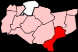
Shepway is a local government district
in Kent
, England
. It includes the towns of Folkestone
and Hythe
and the Romney Marsh
. It is named after the Jutish
lathe of Shepway; the Royal Court of Shepway, which met near Lympne
at a place called Shepway Cross, was the principal court of the Cinque Ports
Federation. Shepway District Council uses the Folkestone White Horse
as a logo.
s. Its council offices are in Folkestone.
In 2011, Lydd Airport's owners – who are seeking to expand the airport – gave "gifts to councillors", which councillors did not declare.
The District Council consists of 46 councillors representing 22 wards. Those wards are:
Following the May 2011 elections, the composition of Shepway District Council is 44 Conservatives and two from the People First party.
The third tier of local government in Shepway consists of town councils in Folkestone, Hythe
, New Romney
and Lydd
; and the following parish councils:
and Canterbury Districts
; on the east by Dover District
and on the south by the Strait of Dover
. The Romney and Walland Marshes
cover a good deal of its area to the west; where the North Downs
begin to reach the sea there is much more in the way of settlement. The four towns in the District are all located along the coast.
and Swale
. Like them, it has a high rate of unemployment; poor educational attainment figures; and with the majority of businesses being small operations.
The major source of economy is, however, tourism
. Events and venues are widely publicised.
crosses the District to end at Folkestone. Other main roads include the A259 south coast road
and the A260 which takes traffic towards Canterbury
. The South Eastern Main Line and High Speed 1 both cross the district: the western end of the Channel Tunnel
is at Cheriton
, west of Folkestone.
The Royal Military Canal
crosses the northern edge of the Romney Marsh; and the Romney, Hythe and Dymchurch Railway
runs out to Dungeness
from Hythe.
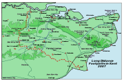 Several long distance footpaths cross the District, including the Saxon Shore Way
and the North Downs Way
; shorter walks include the ’’Elham Valley Walk’’ and the ’’Royal Military Canal Path’’.
Lydd Airport is also in this district.
Non-metropolitan district
Non-metropolitan districts, or colloquially shire districts, are a type of local government district in England. As created, they are sub-divisions of non-metropolitan counties in a so-called "two-tier" arrangement...
in Kent
Kent
Kent is a county in southeast England, and is one of the home counties. It borders East Sussex, Surrey and Greater London and has a defined boundary with Essex in the middle of the Thames Estuary. The ceremonial county boundaries of Kent include the shire county of Kent and the unitary borough of...
, England
England
England is a country that is part of the United Kingdom. It shares land borders with Scotland to the north and Wales to the west; the Irish Sea is to the north west, the Celtic Sea to the south west, with the North Sea to the east and the English Channel to the south separating it from continental...
. It includes the towns of Folkestone
Folkestone
Folkestone is the principal town in the Shepway District of Kent, England. Its original site was in a valley in the sea cliffs and it developed through fishing and its closeness to the Continent as a landing place and trading port. The coming of the railways, the building of a ferry port, and its...
and Hythe
Hythe, Kent
Hythe , is a small coastal market town on the edge of Romney Marsh, in the District of Shepway on the south coast of Kent. The word Hythe or Hithe is an Old English word meaning Haven or Landing Place....
and the Romney Marsh
Romney Marsh
Romney Marsh is a sparsely populated wetland area in the counties of Kent and East Sussex in the south-east of England. It covers about 100 mi ² .-Quotations:*“As Egypt was the gift of the Nile, this level tract .....
. It is named after the Jutish
Anglo-Saxons
Anglo-Saxon is a term used by historians to designate the Germanic tribes who invaded and settled the south and east of Great Britain beginning in the early 5th century AD, and the period from their creation of the English nation to the Norman conquest. The Anglo-Saxon Era denotes the period of...
lathe of Shepway; the Royal Court of Shepway, which met near Lympne
Lympne
Lympne is a village situated on the former sea cliffs above the Romney Marsh in Kent. It lies approximately west of Folkestone, 2 miles west of Hythe and east of Ashford....
at a place called Shepway Cross, was the principal court of the Cinque Ports
Cinque Ports
The Confederation of Cinque Ports is a historic series of coastal towns in Kent and Sussex. It was originally formed for military and trade purposes, but is now entirely ceremonial. It lies at the eastern end of the English Channel, where the crossing to the continent is narrowest...
Federation. Shepway District Council uses the Folkestone White Horse
Folkestone White Horse
The Folkestone White Horse is a white horse hill figure, carved into Cheriton Hill, Folkestone, Kent, South East England. It overlooks the English terminal of the Channel Tunnel and was completed in June 2003....
as a logo.
Governance
The district was formed on 1 April 1974 as a merger of the boroughs of Folkestone, Hythe, Lydd and New Romney, along with Elham and Romney Marsh Rural DistrictRural district
Rural districts were a type of local government area – now superseded – established at the end of the 19th century in England, Wales, and Ireland for the administration of predominantly rural areas at a level lower than that of the administrative counties.-England and Wales:In England...
s. Its council offices are in Folkestone.
In 2011, Lydd Airport's owners – who are seeking to expand the airport – gave "gifts to councillors", which councillors did not declare.
The District Council consists of 46 councillors representing 22 wards. Those wards are:
- Dymchurch and St Mary's Bay
- Elham and Stelling Minnis
- Folkestone: eight wards (Cheriton; Foord; Harbour; Harvey (two wards, Central and West); Morehall; Park; and Sandgate
- Hythe: three wards (Central, East and West)
- Lydd
- Lympne and Stanford
- New Romney: two wards (Town and Coast)
- North Downs: two wards (East and West)
- Romney Marsh
- Tolsford
Following the May 2011 elections, the composition of Shepway District Council is 44 Conservatives and two from the People First party.
The third tier of local government in Shepway consists of town councils in Folkestone, Hythe
Hythe, Kent
Hythe , is a small coastal market town on the edge of Romney Marsh, in the District of Shepway on the south coast of Kent. The word Hythe or Hithe is an Old English word meaning Haven or Landing Place....
, New Romney
New Romney
New Romney is a small town in Kent, England, on the edge of Romney Marsh, an area of flat, rich agricultural land reclaimed from the sea after the harbour began to be silted up. New Romney was once a sea port, with the harbour adjacent to the church, but is now more than a mile from the sea...
and Lydd
Lydd
Lydd is a town in Kent, England, lying on the Romney Marsh. It is one of the larger towns on the Marsh, and the most southerly town in Kent. Actually located on Denge Marsh, Lydd was one of the first sandy islands to form as the bay evolved into what is now called the Romney Marsh...
; and the following parish councils:
- AcriseAcriseAcrise is an ecclesiastical and civil parish in Shepway District, Kent, England, about six miles north of Folkestone. The settlement derives its name from Old English, 'Acrise' being a development of the Old English term for "Oak Rise", the parish being on a small hill, still populated with old oak...
(M) - BrenzettBrenzettBrenzett is a village and civil parish in the Shepway District of Kent, England. The village lies on the Romney Marsh, three miles west of New Romney....
- BrooklandBrookland, KentBrookland is a village and civil parish in the Shepway district of Kent, England, about west of New Romney. According to the 2001 census the parish had a population of 453. It is located on the A259 road in Romney Marsh....
- BurmarshBurmarshBurmarsh is a village and civil parish in the Shepway District of Kent, England. The village is located three miles west of Hythe on the Romney Marsh....
- DymchurchDymchurchDymchurch is a village and civil parish in the Shepway District of Kent, England. The village is located on the coast five miles south-west of Hythe, and on the Romney Marsh. It is typical of this part of the coast, having been a village which became larger during the 1930s...
- ElhamElhamElham is a village in East Kent situated approximately south of Canterbury and north east of Folkestone in the Elham Valley.-Toponomy:The origin of the village's name has always been a matter of argument. The village is listed in the Domesday Book of 1086 as Alham. This may have derived from...
- ElmstedElmstedElmsted is a village and civil parish in the Shepway District of Kent, England. It is located west of Stone Street , the Roman road which today takes traffic between Canterbury and Lympne. Within the parish are the settlements of Bodsham, North Leigh and Evington...
- HawkingeHawkingeHawkinge is a village and civil parish in the Shepway District of Kent, England. The original village of Hawkinge is actually just less than a mile due east of the present village centre ; the modern, much larger, village of Hawkinge was formed by the merging of Hawkinge and Uphill...
- IvychurchIvychurchFor Ivychurch, Wiltshire, see Ivychurch PrioryIvychurch is a village and civil parish in the Shepway District of Kent, England. The village is located on the Romney Marsh, three miles north-west of New Romney. The parish council consists of five members.The village has a public house but has...
- LymingeLymingeLyminge is a village in southeast Kent, England. It lies about five miles from Folkestone and the Channel Tunnel, on the road passing through the Elham Valley. The Nailbourne stream begins in the village and flows north through the Valley, to become one of the tributary streams of the Great Stour...
- LympneLympneLympne is a village situated on the former sea cliffs above the Romney Marsh in Kent. It lies approximately west of Folkestone, 2 miles west of Hythe and east of Ashford....
- Monks HortonMonks HortonMonks Horton is a small civil parish in the Shepway District of Kent, England. It is located north of Hythe. Within the civil parish are the hamlets of Horton and Broad Street. The parish is governed by a parish meeting, rather than a parish council, because of its small size. The name comes from...
(M) - NewchurchNewchurch, KentNewchurch is a village and civil parish in the Shepway District in Kent, England. The village is located on the Romney Marsh, west of Dymchurch...
- NewingtonNewington, ShepwayNewington is a village in Kent, England one mile west-north-west of Folkestone. It gives its name to Newington-Shepway Parish Council, which has five councillors, and includes the hamlets of Arpinge and Beachborough...
- Old RomneyOld RomneyOld Romney is a village and civil parish in the Shepway District of Kent, England.The village, as its name suggests, is the original site of the settlement, and is situated two miles inland from New Romney...
(M) - PaddlesworthPaddlesworthPaddlesworth is a village located about 3 miles NNW of Folkestone in Kent, England, near Hawkinge.The Early Norman Anglican parish church is dedicated to St Oswald. It was built in the 11th century or earlier but underwent alteration in the 13th and restoration in the 19th century...
(M) - PostlingPostlingPostling village and civil parish is situated near the Roman road of Stone Street, about south of Canterbury, Kent, in South East England. Postlinges is the spelling used in the Domesday Book where it was part of the lands of Hugo de Montsort; Postlinge is also seen in old records. There is much...
- St Mary in the MarshSt Mary in the MarshSt Mary in the Marsh is a village near New Romney in Kent, England, situated in the heart of Romney Marsh in one of its least populated areas, but with New Romney just 3 miles away, there are plenty of amenities close by....
- SaltwoodSaltwoodSaltwood is a village and civil parish in the Shepway District of Kent, England. Within the parish are two other settlements: Pedlinge and Sandling; both being small hamlets.-Geography:...
- SandgateSandgate, KentSandgate is a village in the Folkestone and Hythe Urban Area in the Shepway district of Kent, England. In 2004, the village re-acquired civil parish status....
- SellindgeSellindgeSellindge is a civil parish and village on the A20 road between Ashford and Folkestone in Kent, South East England. Sellindge is part of North Downs West Ward of Shepway District Council but part of the Elham ward of Kent County Council....
- SnargateSnargateSnargate is a village near New Romney in Kent, England.Snargate's most surprising claim to fame in the late 19th century, is that it was home to an important artist. Harold Gilman, sometimes called the English Van Gogh, was a British Impressionist and a member of the Camden Town Group. He grew up...
(M) - Stelling MinnisStelling MinnisStelling Minnis is a village and civil parish in the Shepway District in Kent, England. The village lies to the south of Canterbury, and to the east of the B2068, Stone Street, the Roman road, which takes traffic between Lympne and Canterbury.- Windmill :...
- StowtingStowtingStowting lies between Canterbury, Folkestone, Ashford and Hythe. In 1947, a Douglas C-47A crashed on the hillside above the village, killing eight of the 16 people on board.There is a Church of England Primary school.-External links:*...
(M) - StanfordStanford, KentStanford is a village in Kent, England close to Ashford, and within the Parish of Stanford. It has been divided by the M20 into Stanford North and Stanford South. There is a windmill to the north of the M20 and west of Stone Street. The parish church is All Saints.-External links:*...
- Swingfield Parishes marked thus are served by a parish meeting, not a parish council
Geography
Shepway occupies the most southerly part of Kent. It is bounded on the north by AshfordAshford (borough)
Ashford is a local government district and borough in Kent, England. Its council is based in the town of Ashford.The borough was formed on 1 April 1974 by the merger of the borough of Tenterden with Ashford urban district, and the East Ashford, West Ashford and Tenterden Rural Districts...
and Canterbury Districts
City of Canterbury
The City of Canterbury is a local government district with city status in Kent, England. The main settlement in the district is Canterbury, the seat of the Archbishop of Canterbury.-History:...
; on the east by Dover District
Dover (district)
Dover is a local government district in Kent, England. Dover is its administrative centre. It was formed on 1 April 1974 by the merger of the boroughs of Deal, Dover, and Sandwich along with Dover Rural District and most of Eastry Rural District...
and on the south by the Strait of Dover
Strait of Dover
The Strait of Dover or Dover Strait is the strait at the narrowest part of the English Channel. The shortest distance across the strait is from the South Foreland, 6 kilometres northeast of Dover in the county of Kent, England, to Cap Gris Nez, a cape near to Calais in the French of...
. The Romney and Walland Marshes
Romney Marsh
Romney Marsh is a sparsely populated wetland area in the counties of Kent and East Sussex in the south-east of England. It covers about 100 mi ² .-Quotations:*“As Egypt was the gift of the Nile, this level tract .....
cover a good deal of its area to the west; where the North Downs
North Downs
The North Downs are a ridge of chalk hills in south east England that stretch from Farnham in Surrey to the White Cliffs of Dover in Kent. The North Downs lie within two Areas of Outstanding Natural Beauty , the Surrey Hills and the Kent Downs...
begin to reach the sea there is much more in the way of settlement. The four towns in the District are all located along the coast.
Economy
In economic terms, Shepway is the third most deprived area in Kent, after ThanetThanet
Thanet is a local government district of Kent, England which was formed under the Local Government Act 1972, and came into being on 1 April 1974...
and Swale
Swale
Swale is a local government district with borough status in Kent, England. Its council is based in Sittingbourne. The borough is named after the narrow channel called The Swale, a channel that separates the mainland of Kent from the Isle of Sheppey, and which occupies the central part of the...
. Like them, it has a high rate of unemployment; poor educational attainment figures; and with the majority of businesses being small operations.
The major source of economy is, however, tourism
Tourism
Tourism is travel for recreational, leisure or business purposes. The World Tourism Organization defines tourists as people "traveling to and staying in places outside their usual environment for not more than one consecutive year for leisure, business and other purposes".Tourism has become a...
. Events and venues are widely publicised.
Transport
The M20 motorwayM20 motorway
The M20 is a motorway in Kent, England. It runs from the M25 motorway to Folkestone, providing a link to the Channel Tunnel and the ports at Dover. It is long...
crosses the District to end at Folkestone. Other main roads include the A259 south coast road
A259 road
The A259 is a busy road on the south coast of England passing through Hampshire, West Sussex, East Sussex and part of Kent. Part of the road was named "the most dangerous road in South East England" in 2008.-Description:...
and the A260 which takes traffic towards Canterbury
Canterbury
Canterbury is a historic English cathedral city, which lies at the heart of the City of Canterbury, a district of Kent in South East England. It lies on the River Stour....
. The South Eastern Main Line and High Speed 1 both cross the district: the western end of the Channel Tunnel
Channel Tunnel
The Channel Tunnel is a undersea rail tunnel linking Folkestone, Kent in the United Kingdom with Coquelles, Pas-de-Calais near Calais in northern France beneath the English Channel at the Strait of Dover. At its lowest point, it is deep...
is at Cheriton
Cheriton, Kent
Cheriton is a northern suburb of Folkestone in Kent that is the location of the English terminal of the Channel Tunnel. It is the location of the major army barracks of Shorncliffe Camp.- History :...
, west of Folkestone.
The Royal Military Canal
Royal Military Canal
The Royal Military Canal is a canal running for 28 miles between Seabrook near Folkestone and Cliff End near Hastings, following the old cliff line bordering Romney Marsh.-Construction:...
crosses the northern edge of the Romney Marsh; and the Romney, Hythe and Dymchurch Railway
Romney, Hythe and Dymchurch Railway
The Romney, Hythe & Dymchurch Railway is a gauge light railway in Kent, England. The line runs from the Cinque Port of Hythe via Dymchurch, St...
runs out to Dungeness
Dungeness railway station
Dungeness railway station is a station on the Romney, Hythe and Dymchurch Railway on Romney Marsh in Kent.-History:The line to Dungeness was opened on 24 May 1928, a year after the line reached New Romney...
from Hythe.
Saxon Shore Way
The Saxon Shore Way is a long-distance footpath in England, starting at Gravesend, Kent and traces the coast as it was in Roman times as far as Hastings, East Sussex, in total.-History:...
and the North Downs Way
North Downs Way
The North Downs Way is a long-distance path in southern England, opened in 1978. It runs from Farnham to Dover, past Godalming, Guildford, Dorking, Merstham, Otford and Rochester, along the Surrey Hills Area of Outstanding Natural Beauty and Kent Downs AONB.East of Boughton Lees, the path splits...
; shorter walks include the ’’Elham Valley Walk’’ and the ’’Royal Military Canal Path’’.
Lydd Airport is also in this district.