
North Downs Way
Encyclopedia
England
England is a country that is part of the United Kingdom. It shares land borders with Scotland to the north and Wales to the west; the Irish Sea is to the north west, the Celtic Sea to the south west, with the North Sea to the east and the English Channel to the south separating it from continental...
, opened in 1978. It runs from Farnham
Farnham
Farnham is a town in Surrey, England, within the Borough of Waverley. The town is situated some 42 miles southwest of London in the extreme west of Surrey, adjacent to the border with Hampshire...
to Dover
Dover
Dover is a town and major ferry port in the home county of Kent, in South East England. It faces France across the narrowest part of the English Channel, and lies south-east of Canterbury; east of Kent's administrative capital Maidstone; and north-east along the coastline from Dungeness and Hastings...
, past Godalming
Godalming
Godalming is a town and civil parish in the Waverley district of the county of Surrey, England, south of Guildford. It is built on the banks of the River Wey and is a prosperous part of the London commuter belt. Godalming shares a three-way twinning arrangement with the towns of Joigny in France...
, Guildford
Guildford
Guildford is the county town of Surrey. England, as well as the seat for the borough of Guildford and the administrative headquarters of the South East England region...
, Dorking
Dorking
Dorking is a historic market town at the foot of the North Downs approximately south of London, in Surrey, England.- History and development :...
, Merstham
Merstham
Merstham is a village in the Reigate and Banstead borough of Surrey, England, in the London commuter belt. It is just north of Redhill, near the intersection of the M25 and M23 motorways, on the edge of the North Downs and on the North Downs Way.-History:...
, Otford
Otford
Otford is a village and civil parish in the Sevenoaks District of Kent known for its classically British countryside. The village is located on the River Darent, flowing north down its valley from its source on the North Downs...
and Rochester, along the Surrey Hills
Surrey Hills AONB
The Surrey Hills is a Area of Outstanding Natural Beauty , located in Surrey, England. The AONB was designated in 1958 and covers one quarter of the county of Surrey...
Area of Outstanding Natural Beauty (AONB) and Kent Downs AONB
Kent Downs AONB
Kent Downs is an Area of Outstanding Natural Beauty in Kent, England . They are the eastern half of the North Downs and stretch from the London/Surrey borders to the White Cliffs of Dover...
.
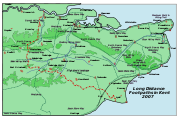
East of Boughton Lees
Boughton Lees
Boughton Lees is a village in the civil parish of Boughton Aluph and Eastwell, Ashford District, Kent, England. It stands on the main Ashford-Faversham road, some 3.5 miles north of Ashford....
, the path splits in two, the northern section running via Canterbury
Canterbury
Canterbury is a historic English cathedral city, which lies at the heart of the City of Canterbury, a district of Kent in South East England. It lies on the River Stour....
and the southern via Wye; at this stage the path crosses the Stour Valley Walk
Stour Valley Walk
The Stour Valley Walk is a recreational walking route that follows the River Stour, through the Low Weald and Kent Downs, from its source at Lenham to its estuary at Pegwell Bay....
and passes the Wye Crown. The two sections of the path reunite at Dover. The northern route is 211 km long, and the southern route 201 km, the total length of the North Downs Way being 246 km.
The pathway is mixed-category in that it varies throughout length from footpath status to bridleway, byway and road. Some 19% of the Way follows roads, though 75% of those are minor lanes.
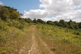
The path (east of Boughton Lees, the southern section) runs along the ridge of the North Downs
North Downs
The North Downs are a ridge of chalk hills in south east England that stretch from Farnham in Surrey to the White Cliffs of Dover in Kent. The North Downs lie within two Areas of Outstanding Natural Beauty , the Surrey Hills and the Kent Downs...
hills, and roughly follows the Pilgrims' Way
Pilgrims' Way
The Pilgrims' Way is the historic route supposed to have been taken by pilgrims from Winchester in Hampshire, England, to the shrine of Thomas Becket at Canterbury in Kent...
path used by many pilgrim
Pilgrim
A pilgrim is a traveler who is on a journey to a holy place. Typically, this is a physical journeying to some place of special significance to the adherent of a particular religious belief system...
s in the Middle Ages
Middle Ages
The Middle Ages is a periodization of European history from the 5th century to the 15th century. The Middle Ages follows the fall of the Western Roman Empire in 476 and precedes the Early Modern Era. It is the middle period of a three-period division of Western history: Classic, Medieval and Modern...
.
As the pathway runs through the downland
Downland
A downland is an area of open chalk hills. This term is especially used to describe the chalk countryside in southern England. Areas of downland are often referred to as Downs....
, the trails and surrounding countryside are characterised by chalk
Chalk
Chalk is a soft, white, porous sedimentary rock, a form of limestone composed of the mineral calcite. Calcite is calcium carbonate or CaCO3. It forms under reasonably deep marine conditions from the gradual accumulation of minute calcite plates shed from micro-organisms called coccolithophores....
-based soil
Soil
Soil is a natural body consisting of layers of mineral constituents of variable thicknesses, which differ from the parent materials in their morphological, physical, chemical, and mineralogical characteristics...
and calcareous grassland
Calcareous grassland
Calcareous grassland is an ecosystem associated with thin basic soil, such as that on chalk and limestone downland. Plants on calcareous grassland are typically short and hardy, and include grasses and herbs such as clover...
with livestock
Livestock
Livestock refers to one or more domesticated animals raised in an agricultural setting to produce commodities such as food, fiber and labor. The term "livestock" as used in this article does not include poultry or farmed fish; however the inclusion of these, especially poultry, within the meaning...
grazing
Grazing
Grazing generally describes a type of feeding, in which a herbivore feeds on plants , and also on other multicellular autotrophs...
on the down slopes and clay
Clay
Clay is a general term including many combinations of one or more clay minerals with traces of metal oxides and organic matter. Geologic clay deposits are mostly composed of phyllosilicate minerals containing variable amounts of water trapped in the mineral structure.- Formation :Clay minerals...
soil and crop
Crop (agriculture)
A crop is a non-animal species or variety that is grown to be harvested as food, livestock fodder, fuel or for any other economic purpose. Major world crops include maize , wheat, rice, soybeans, hay, potatoes and cotton. While the term "crop" most commonly refers to plants, it can also include...
agriculture
Agriculture
Agriculture is the cultivation of animals, plants, fungi and other life forms for food, fiber, and other products used to sustain life. Agriculture was the key implement in the rise of sedentary human civilization, whereby farming of domesticated species created food surpluses that nurtured the...
predominant in the valleys.