

Great Wagon Road
Encyclopedia
Colonial America
The colonial history of the United States covers the history from the start of European settlement and especially the history of the thirteen colonies of Britain until they declared independence in 1776. In the late 16th century, England, France, Spain and the Netherlands launched major...
n improved trail transiting the Great Appalachian Valley
Great Appalachian Valley
The Great Valley, also called the Great Appalachian Valley or Great Valley Region, is one of the major landform features of eastern North America. It is a gigantic trough — a chain of valley lowlands — and the central feature of the Appalachian Mountain system...
from Pennsylvania
Pennsylvania
The Commonwealth of Pennsylvania is a U.S. state that is located in the Northeastern and Mid-Atlantic regions of the United States. The state borders Delaware and Maryland to the south, West Virginia to the southwest, Ohio to the west, New York and Ontario, Canada, to the north, and New Jersey to...
to North Carolina
North Carolina
North Carolina is a state located in the southeastern United States. The state borders South Carolina and Georgia to the south, Tennessee to the west and Virginia to the north. North Carolina contains 100 counties. Its capital is Raleigh, and its largest city is Charlotte...
, and from there to Georgia
Georgia (U.S. state)
Georgia is a state located in the southeastern United States. It was established in 1732, the last of the original Thirteen Colonies. The state is named after King George II of Great Britain. Georgia was the fourth state to ratify the United States Constitution, on January 2, 1788...
.
The Great Wagon Road was the heavily traveled main route for settlement of the Southern United States, particularly the "backcountry
Backcountry
A backcountry area in general terms is a geographical region that is:* isolated* remote* undeveloped* difficult to accessThe term may apply to various regions that are reasonably close to urban areas but are:* not immediately accessible by car...
". This was the area that received the great proportion of German and Scots-Irish immigrants in the 18th century. The Scots-Irish and English from the Anglo-Scottish border
Anglo-Scottish border
The Anglo-Scottish border is the official border and mark of entry between Scotland and England. It runs for 154 km between the River Tweed on the east coast and the Solway Firth in the west. It is Scotland's only land border...
area were the largest group of immigrants from the British Isles before the American Revolution.
Beginning at the port of Philadelphia, where many immigrants entered the colonies, the Great Wagon Road passed through the towns of Lancaster
Lancaster, Pennsylvania
Lancaster is a city in the south-central part of the Commonwealth of Pennsylvania. It is the county seat of Lancaster County and one of the older inland cities in the United States, . With a population of 59,322, it ranks eighth in population among Pennsylvania's cities...
and York
York, Pennsylvania
York, known as the White Rose City , is a city located in York County, Pennsylvania, United States which is in the South Central region of the state. The population within the city limits was 43,718 at the 2010 census, which was a 7.0% increase from the 2000 count of 40,862...
in southeastern Pennsylvania
Pennsylvania
The Commonwealth of Pennsylvania is a U.S. state that is located in the Northeastern and Mid-Atlantic regions of the United States. The state borders Delaware and Maryland to the south, West Virginia to the southwest, Ohio to the west, New York and Ontario, Canada, to the north, and New Jersey to...
. Portions of the Great Wagon Road traveled to present-day Mechanicsburg
Mechanicsburg, Pennsylvania
Mechanicsburg is a borough in Cumberland County, Pennsylvania, USA, eight miles west of Harrisburg. It is part of the Harrisburg–Carlisle Metropolitan Statistical Area. Mechanicsburg was settled in 1806 and incorporated as a borough on April 12, 1828...
, about 30 miles (48.3 km) northwest of York. Mechanicsburg derives its name from the many mechanics who set up shop there to do business with the numerous wagon trains traveling through town.
Turning southwest, the road crossed the Potomac River
Potomac River
The Potomac River flows into the Chesapeake Bay, located along the mid-Atlantic coast of the United States. The river is approximately long, with a drainage area of about 14,700 square miles...
at Harpers Ferry and entered the Shenandoah Valley
Shenandoah Valley
The Shenandoah Valley is both a geographic valley and cultural region of western Virginia and West Virginia in the United States. The valley is bounded to the east by the Blue Ridge Mountains, to the west by the eastern front of the Ridge-and-Valley Appalachians , to the north by the Potomac River...
at Winchester, Virginia
Winchester, Virginia
Winchester is an independent city located in the northwestern portion of the Commonwealth of Virginia in the USA. The city's population was 26,203 according to the 2010 Census...
, continuing south in the valley via the Great Warriors' Trail (also called the Indian Road, as on this map), which was established by centuries of Native American
Native Americans in the United States
Native Americans in the United States are the indigenous peoples in North America within the boundaries of the present-day continental United States, parts of Alaska, and the island state of Hawaii. They are composed of numerous, distinct tribes, states, and ethnic groups, many of which survive as...
travel. The Treaty of Lancaster
Treaty of Lancaster
The Treaty of Lancaster was a treaty concluded between the Six Nations and the colonies of Virginia and Maryland. Deliberations began at Lancaster, Pennsylvania on June 28, and ended on July 4, 1744....
had established colonists' rights to use the Indian Road. The Shenandoah portion of the road is also known as the Valley Pike
Valley Pike
Valley Pike or Valley Turnpike is the traditional name given for the Indian trail and roadway which now is designated as U.S. Highway 11 in the Shenandoah Valley of Virginia....
.
South of the Shenandoah Valley, the road reached the Roanoke River
Roanoke River
The Roanoke River is a river in southern Virginia and northeastern North Carolina in the United States, 410 mi long. A major river of the southeastern United States, it drains a largely rural area of the coastal plain from the eastern edge of the Appalachian Mountains southeast across the Piedmont...
at the town of Big Lick (today, Roanoke
Roanoke, Virginia
Roanoke is an independent city in the Mid-Atlantic U.S. state of Virginia and is the tenth-largest city in the Commonwealth. It is located in the Roanoke Valley of the Roanoke Region of Virginia. The population within the city limits was 97,032 as of 2010...
). South of Roanoke, the Great Wagon Road was also called the Carolina Road. At Roanoke, a road forked southwest, leading into the upper New River Valley
New River Valley
The New River Valley is a region in the eastern United States along the New River in the Commonwealth of Virginia . The valley comprises the counties of Montgomery , Pulaski, Floyd, Giles and the independent City of Radford...
and on to the Holston River
Holston River
The Holston River is a major river system of southwestern Virginia and east Tennessee. The three major forks of the Holston rise in southwestern Virginia and have their confluence near Kingsport, Tennessee. The North Fork flows southwest from Sharon Springs in Bland County, Virginia...
in the upper Tennessee Valley
Tennessee Valley
The Tennessee Valley is the drainage basin of the Tennessee River and is largely within the U.S. state of Tennessee. It stretches from southwest Kentucky to northwest Georgia and from northeast Mississippi to the mountains of Virginia and North Carolina...
. From there, the Wilderness Road
Wilderness Road
The Wilderness Road was the principal route used by settlers for more than fifty years to reach Kentucky from the East. In 1775, Daniel Boone blazed a trail for the Transylvania Company from Fort Chiswell in Virginia through the Cumberland Gap into central Kentucky. It was later lengthened,...
led into Kentucky
Kentucky
The Commonwealth of Kentucky is a state located in the East Central United States of America. As classified by the United States Census Bureau, Kentucky is a Southern state, more specifically in the East South Central region. Kentucky is one of four U.S. states constituted as a commonwealth...
.
From Big Lick/Roanoke, the Great Wagon Road passed through the Roanoke River Gap to the east side of the Blue Ridge Mountains
Blue Ridge Mountains
The Blue Ridge Mountains are a physiographic province of the larger Appalachian Mountains range. This province consists of northern and southern physiographic regions, which divide near the Roanoke River gap. The mountain range is located in the eastern United States, starting at its southern-most...
. It continued south through the Piedmont
Piedmont (United States)
The Piedmont is a plateau region located in the eastern United States between the Atlantic Coastal Plain and the main Appalachian Mountains, stretching from New Jersey in the north to central Alabama in the south. The Piedmont province is a physiographic province of the larger Appalachian division...
region. It passed through the present-day North Carolina
North Carolina
North Carolina is a state located in the southeastern United States. The state borders South Carolina and Georgia to the south, Tennessee to the west and Virginia to the north. North Carolina contains 100 counties. Its capital is Raleigh, and its largest city is Charlotte...
towns of Winston-Salem
Winston-Salem, North Carolina
Winston-Salem is a city in the U.S. state of North Carolina, with a 2010 population of 229,617. Winston-Salem is the county seat and largest city of Forsyth County and the fourth-largest city in the state. Winston-Salem is the second largest municipality in the Piedmont Triad region and is home to...
, Salisbury
Salisbury, North Carolina
Salisbury is a city in Rowan County in North Carolina, a state of the United States of America. The population was 33,663 in the 2010 Census . It is the county seat of Rowan County...
, and Charlotte
Charlotte, North Carolina
Charlotte is the largest city in the U.S. state of North Carolina and the seat of Mecklenburg County. In 2010, Charlotte's population according to the US Census Bureau was 731,424, making it the 17th largest city in the United States based on population. The Charlotte metropolitan area had a 2009...
(all part of the Piedmont Crescent
Piedmont Crescent
The Piedmont Crescent, also known as the Piedmont Urban Crescent, is a large, polycentric urbanized region in the U.S. state of North Carolina that forms the northern section of the rapidly developing I-85 Corridor megalopolis in the southeastern United States...
and sites of earlier Native American settlements on the historic Indian Trading Path
Trading Path
The Trading Path is not simply one wide path, as many named historic roads were or are...
). The Great Wagon Road ultimately reached Augusta, Georgia
Augusta, Georgia
Augusta is a consolidated city in the U.S. state of Georgia, located along the Savannah River. As of the 2010 census, the Augusta–Richmond County population was 195,844 not counting the unconsolidated cities of Hephzibah and Blythe.Augusta is the principal city of the Augusta-Richmond County...
on the Savannah River
Savannah River
The Savannah River is a major river in the southeastern United States, forming most of the border between the states of South Carolina and Georgia. Two tributaries of the Savannah, the Tugaloo River and the Chattooga River, form the northernmost part of the border...
.
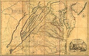
Despite its current name, the southern part of this road was by no means passable by wagons until later Colonial times. The 1751 Fry-Jefferson map on this page notes the term 'Waggon' only north of Winchester.
See also
- Interstate 81Interstate 81Interstate 81 is an Interstate Highway in the eastern part of the United States. Its southern terminus is at Interstate 40 in Dandridge, Tennessee; its northern terminus is on Wellesley Island at the Canadian border, where the Thousand Islands Bridge connects it to Highway 401, the main freeway...
- Philadelphia and Lancaster TurnpikePhiladelphia and Lancaster TurnpikeThe Philadelphia and Lancaster Turnpike, first used in 1795, is the first long-distance paved road built in the United States, according to engineered plans and specifications. It links Lancaster, Pennsylvania, and Philadelphia at 34th Street, stretching for sixty-two miles. However, the western...
- U.S. Route 11U.S. Route 11U.S. Route 11 is a north–south United States highway extending 1,645 miles across the eastern United States. The southern terminus of the route is at U.S. Route 90 in the Bayou Sauvage National Wildlife Refuge in eastern New Orleans, Louisiana. The northern terminus is at the United...
- U.S. Route 30U.S. Route 30U.S. Route 30 is an east–west main route of the system of United States Numbered Highways, with the highway traveling across the northern tier of the country. It is the third longest U.S. route, after U.S. Route 20 and U.S. Route 6. The western end of the highway is at Astoria, Oregon; the...