
Shenandoah River
Encyclopedia
Tributary
A tributary or affluent is a stream or river that flows into a main stem river or a lake. A tributary does not flow directly into a sea or ocean...
of the Potomac River
Potomac River
The Potomac River flows into the Chesapeake Bay, located along the mid-Atlantic coast of the United States. The river is approximately long, with a drainage area of about 14,700 square miles...
, 55.6 miles (89.5 km) long with two forks approximately 100 miles (160.9 km) long each, in the U.S. state
U.S. state
A U.S. state is any one of the 50 federated states of the United States of America that share sovereignty with the federal government. Because of this shared sovereignty, an American is a citizen both of the federal entity and of his or her state of domicile. Four states use the official title of...
s of Virginia
Virginia
The Commonwealth of Virginia , is a U.S. state on the Atlantic Coast of the Southern United States. Virginia is nicknamed the "Old Dominion" and sometimes the "Mother of Presidents" after the eight U.S. presidents born there...
and West Virginia
West Virginia
West Virginia is a state in the Appalachian and Southeastern regions of the United States, bordered by Virginia to the southeast, Kentucky to the southwest, Ohio to the northwest, Pennsylvania to the northeast and Maryland to the east...
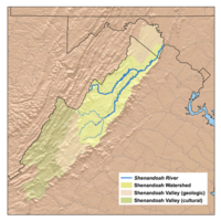
. The principal tributary of the Potomac, the river and its tributaries drain the central and lower Shenandoah Valley
Shenandoah Valley
The Shenandoah Valley is both a geographic valley and cultural region of western Virginia and West Virginia in the United States. The valley is bounded to the east by the Blue Ridge Mountains, to the west by the eastern front of the Ridge-and-Valley Appalachians , to the north by the Potomac River...
and the Page Valley
Page Valley
The Page Valley is a small valley geographically and culturally associated with the Shenandoah Valley. The valley is located between the Massanutten and Blue Ridge mountain ranges in western Virginia.-Geography:The valley is approximately long...
in the Appalachians
Appalachian Mountains
The Appalachian Mountains #Whether the stressed vowel is or ,#Whether the "ch" is pronounced as a fricative or an affricate , and#Whether the final vowel is the monophthong or the diphthong .), often called the Appalachians, are a system of mountains in eastern North America. The Appalachians...
on the west side of the Blue Ridge Mountains
Blue Ridge Mountains
The Blue Ridge Mountains are a physiographic province of the larger Appalachian Mountains range. This province consists of northern and southern physiographic regions, which divide near the Roanoke River gap. The mountain range is located in the eastern United States, starting at its southern-most...
, in northwestern Virginia and the Eastern Panhandle
Eastern Panhandle of West Virginia
The Eastern Panhandle of West Virginia is a narrow stretch of territory in the northeast of the state, bordering Maryland and Virginia, United States. The Eastern Panhandle Board of Realtors and other local civic organizations consider only the three Easternmost counties, Jefferson, Berkeley and...
of West Virginia
West Virginia
West Virginia is a state in the Appalachian and Southeastern regions of the United States, bordered by Virginia to the southeast, Kentucky to the southwest, Ohio to the northwest, Pennsylvania to the northeast and Maryland to the east...
.
Course
The Shenandoah River is formed northeast of Front RoyalFront Royal, Virginia
Front Royal is a town in Warren County, Virginia, United States. The population was 13,589 at the 2000 census. It is the county seat of Warren County.-Geography:Front Royal is roughly west of Washington, D.C....
near Riverton, by the confluence
Confluence (geography)
In geography, a confluence is the meeting of two or more bodies of water. It usually refers to the point where two streams flow together, merging into a single stream...
of the South Fork and the North Fork. It flows northeast across Warren County
Warren County, Virginia
As of the census of 2000, there were 31,584 people, 12,087 households, and 8,521 families residing in the county. The population density was 148 people per square mile . There were 13,299 housing units at an average density of 62 per square mile...
, passing underneath Interstate 66
Interstate 66
Interstate 66 is an Interstate Highway in the eastern United States. As indicated by its even route number, it runs in an east–west direction. Its western terminus is at Middletown, Virginia, at an intersection with Interstate 81; its eastern terminus is in Washington, D.C., at an...
1 miles (1.6 km) from its formation. Beyond the I-66 bridge the river flows through a set of bends before turning to the northeast again, crossing into Clarke County
Clarke County, Virginia
Clarke County is a county in the Commonwealth of Virginia. As of 2010, the population was 14,034. Its county seat is Berryville.-History:Clarke County was established in 1836 by Thomas Fairfax, 6th Lord Fairfax of Cameron who built a home, Greenway Court, on part of his 5 million acre property,...
11 miles (17.7 km) below I-66. 5 miles (8 km) downriver from the Clarke County border, the Shenandoah passes under U.S. Route 50
U.S. Route 50
U.S. Route 50 is a major east–west route of the U.S. Highway system, stretching just over from Ocean City, Maryland on the Atlantic Ocean to West Sacramento, California. Until 1972, when it was replaced by Interstate Highways west of the Sacramento area, it extended to San Francisco, near...
and then passes through a triple bend. 14.5 miles (23.3 km) below the Route 50 bridge, the river passes underneath Virginia Route 7 and then continues northeast another 8 miles (12.9 km) before crossing into Jefferson County
Jefferson County, West Virginia
Jefferson County is a county located in the U.S. state of West Virginia. As of 2010, the population was 53,498. Its county seat is Charles Town...
in West Virginia, in the extreme eastern tip of the state. Once in West Virginia the river completes six large bends before joining with the Potomac from the south near Harpers Ferry
Harpers Ferry, West Virginia
Harpers Ferry is a historic town in Jefferson County, West Virginia, United States. In many books the town is called "Harper's Ferry" with an apostrophe....
20 miles (32.2 km), from the Virginia-West Virginia border.
Geology
The Shenandoah valleyShenandoah Valley
The Shenandoah Valley is both a geographic valley and cultural region of western Virginia and West Virginia in the United States. The valley is bounded to the east by the Blue Ridge Mountains, to the west by the eastern front of the Ridge-and-Valley Appalachians , to the north by the Potomac River...
is underlain by limestone
Limestone
Limestone is a sedimentary rock composed largely of the minerals calcite and aragonite, which are different crystal forms of calcium carbonate . Many limestones are composed from skeletal fragments of marine organisms such as coral or foraminifera....
. The fertile soil made it a favored place for early settlement. It continues to be a major agricultural
Agriculture
Agriculture is the cultivation of animals, plants, fungi and other life forms for food, fiber, and other products used to sustain life. Agriculture was the key implement in the rise of sedentary human civilization, whereby farming of domesticated species created food surpluses that nurtured the...
area of Virginia and West Virginia. Some karst topography
Karst topography
Karst topography is a geologic formation shaped by the dissolution of a layer or layers of soluble bedrock, usually carbonate rock such as limestone or dolomite, but has also been documented for weathering resistant rocks like quartzite given the right conditions.Due to subterranean drainage, there...
is evident, and the limestone is honeycombed with caves. Several have been developed as commercial tourist attractions, including Luray Caverns
Luray Caverns
Luray Caverns, originally called Luray Cave, is a large, celebrated commercial cave just west of Luray, Virginia, USA, which has drawn many visitors since its discovery in 1878. The underground cavern system is generously adorned with speleothems...
, Shenandoah Caverns
Shenandoah Caverns
Shenandoah Caverns is a commercial show cave in the Shenandoah Valley of Virginia. The word Shenandoah has an uncertain Native American origin and meaning. One meaning is said to be "daughter of the stars"....
, and Skyline Caverns
Skyline Caverns
Skyline Caverns, is a series of geologic caves and a tourist attraction located in Front Royal, Virginia. The caverns were discovered by Walter S. Amos, a retired geologist and mineralogist from Winchester, Virginia, on December 17, 1937.-History:...
.
On the riverbank a few miles above Harper's Ferry is said to be a cave with an opening just large enough for a mounted rider to squeeze through. It widened in the interior to a spacious room where hundreds of Col. John Mosby's
John S. Mosby
John Singleton Mosby , nicknamed the "Gray Ghost", was a Confederate cavalry battalion commander in the American Civil War...
raiding troops are said to have hidden from pursuing Union cavalry.
Environmental issues
Since 2005, the Shenandoah River has experienced a series of fish killFish kill
The term fish kill, known also as fish die-off and as fish mortality, is a localized die-off of fish populations which may also be associated with more generalised mortality of aquatic life...
s every spring that have affected several of its native fish species. In the spring of 2005, redbreast sunfish
Redbreast sunfish
The redbreast sunfish is a species of freshwater fish in the sunfish family of order Perciformes. The type species of its genus, it is native to the river systems of eastern Canada and the United States....
and smallmouth bass
Smallmouth bass
The smallmouth bass is a species of freshwater fish in the sunfish family of the order Perciformes. It is the type species of its genus...
along 100 miles (160.9 km) stretch of the South Fork Shenandoah River began dying of lesions caused by bacteria and fungi. Although the fish kill eventually wiped out 80% of the adult redbreast sunfish and smallmouth bass, juvenile populations appeared to be unaffected. The following year more-localized fish kills in Clarke County
Clarke County, Virginia
Clarke County is a county in the Commonwealth of Virginia. As of 2010, the population was 14,034. Its county seat is Berryville.-History:Clarke County was established in 1836 by Thomas Fairfax, 6th Lord Fairfax of Cameron who built a home, Greenway Court, on part of his 5 million acre property,...
spread to two of the Shenandoah's three species of sucker, the shorthead redhorse
Shorthead redhorse
-Introduction:The Shorthead Redhorse is a wide-ranging species in North America that needs to be monitored throughout its range. The Shorthead Redhorse is native to central and eastern North America. However, its range has expanded to include areas like the Hudson estuary and Grayson County, Texas...
and the northern hogsucker
Northern hogsucker
The northern hogsucker, Hypentelium nigricans, belongs to the Catostomidae family of sucker fish. The fish inhabits the rivers of the Mississippi basin, found from Oklahoma and Alabama northward to Minnesota. It prefers clear, fast streams, where it can forage through pebbles for bottom life,...
- the former suffering from similar lesions witnessed in the previous year's fish kill. Virginia's Department of Environmental Quality again received reports of fish kills near Elkton and between Bentonville and Front Royal in late-April 2007 and observed fish exhibiting lesions and strange behavior.
Culture
The folk song "Oh ShenandoahOh Shenandoah
"Oh Shenandoah" is a traditional American folk song of uncertain origin, dating at least to the early 19th century...
" has been covered by a number of different artists including Tennessee Ernie Ford
Tennessee Ernie Ford
Ernest Jennings Ford , better known as Tennessee Ernie Ford, was an American recording artist and television host who enjoyed success in the country and Western, pop, and gospel musical genres...
, the Statler Brothers, jazz guitarist Bill Frisell
Bill Frisell
William Richard "Bill" Frisell is an American guitarist and composer.One of the leading guitarists in jazz since the late 1980s, Frisell's eclectic music touches on progressive folk, classical music, country music, noise and more...
, and Bruce Springsteen
Bruce Springsteen
Bruce Frederick Joseph Springsteen , nicknamed "The Boss," is an American singer-songwriter who records and tours with the E Street Band...
. The song may or may not refer to the Shenandoah River or Valley.
The Shenandoah River figures prominently in John Denver
John Denver
Henry John Deutschendorf, Jr. , known professionally as John Denver, was an American singer/songwriter, activist, and humanitarian. After growing up in numerous locations with his military family, Denver began his music career in folk music groups in the late 1960s. His greatest commercial success...
's "Take Me Home, Country Roads
Take Me Home, Country Roads
"Take Me Home, Country Roads" is a song written by John Denver, Taffy Nivert, and Bill Danoff and initially recorded by John Denver. It was included on his 1971 breakout album Poems, Prayers and Promises; the single went to #2 on the U.S. Billboard Hot 100...
," which associates the river with the state of West Virginia
West Virginia
West Virginia is a state in the Appalachian and Southeastern regions of the United States, bordered by Virginia to the southeast, Kentucky to the southwest, Ohio to the northwest, Pennsylvania to the northeast and Maryland to the east...
. Only the last 20 miles (32.2 km) of the river are in the semi-detached Eastern Panhandle
Eastern Panhandle of West Virginia
The Eastern Panhandle of West Virginia is a narrow stretch of territory in the northeast of the state, bordering Maryland and Virginia, United States. The Eastern Panhandle Board of Realtors and other local civic organizations consider only the three Easternmost counties, Jefferson, Berkeley and...
of West Virginia, with the vast majority of the river and its forks and tributaries flowing through Virginia.
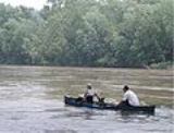
Recreation
The Shenandoah River is a very popular river for canoeing, tubing, and white water rafting (class I-III in season, II-III+ during the spring run-off), and several commercial outfitters offer a variety of guided trips and rentals. Those willing to brave the colder water of spring will be rewarded with a more challenging big-water experience.South Fork Shenandoah River
The South Fork is formed at Port RepublicPort Republic, Virginia
Port Republic is an unincorporated community in Rockingham County, Virginia, United States. The Battle of Port Republic occurred there in the American Civil War.-History:...
in southern Rockingham County
Rockingham County, Virginia
As of the census of 2000, there were 67,725 people, 25,355 households, and 18,889 families residing in the county. The population density was 80 people per square mile . There were 27,328 housing units at an average density of 32 per square mile...
, by the confluence
Confluence (geography)
In geography, a confluence is the meeting of two or more bodies of water. It usually refers to the point where two streams flow together, merging into a single stream...
of the North River and South River. It flows 98.5 miles (158.5 km) northeast in a tight meander
Meander
A meander in general is a bend in a sinuous watercourse. A meander is formed when the moving water in a stream erodes the outer banks and widens its valley. A stream of any volume may assume a meandering course, alternately eroding sediments from the outside of a bend and depositing them on the...
ing course, past Elkton
Elkton, Virginia
Elkton is an incorporated town in Rockingham County, Virginia, United States. It is included in the Harrisonburg, Virginia Metropolitan Statistical Area. The population was 2,042 at the 2000 census. Elkton was named for the Elk Run stream.It is located along the south fork of the Shenandoah River...
and Shenandoah
Shenandoah, Virginia
Shenandoah is a town in Page County, Virginia, United States. The population was 1,878 at the 2000 census.-Geography:Shenandoah is located at ....
, through Page Valley, with the Blue Ridge Mountains to the east and the Massanutten Mountain
Massanutten Mountain
Massanutten Mountain is a synclinal ridge in the Ridge-and-Valley Appalachians, located in the U.S. state of Virginia.-Geography:The mountain bisects the Shenandoah Valley just east of Strasburg in Shenandoah County in the north, to its highest peak east of Harrisonburg in Rockingham County in the...
range to the west.
South Fork tributaries
- North RiverNorth River (South Fork Shenandoah River)The North River is a river in the mountains and Shenandoah Valley of northern Virginia, the United States. It joins the South River at Port Republic to form the South Fork Shenandoah River....
- Middle RiverMiddle River (Virginia)The Middle River is a river in the U.S. state of Virginia. Flowing entirely within Augusta County, the Middle River joins the North River, which in turn meets the South River at Port Republic to form the South Fork Shenandoah River.-References:...
- Middle River
- South RiverSouth River (South Fork Shenandoah River)The South River is one of the two main tributaries of the South Fork of the Shenandoah River. It begins south of Staunton, Virginia, and flows northward to Port Republic, where it merges with the North River to form the South Fork...
- Back Creek
North Fork Shenandoah River
The North Fork is 105 miles (169 km) long and rises in northern Rockingham CountyRockingham County, Virginia
As of the census of 2000, there were 67,725 people, 25,355 households, and 18,889 families residing in the county. The population density was 80 people per square mile . There were 27,328 housing units at an average density of 32 per square mile...
, along the eastern flank of Shenandoah Mountain in the George Washington National Forest. At its formation, the principal feeder on the North Fork is the German River
German River
The German River is the principal tributary of the North Fork of the Shenandoah River, flowing for in the U.S. state of Virginia. The river originates in northern Rockingham County, just east of the West Virginia border, in the George Washington National Forest, near the crest of Shenandoah...
. The North Fork flows initially southeast, down from the mountains, then northeast through a valley across Shenandoah County
Shenandoah County, Virginia
As of the census of 2000, there were 35,075 people, 14,296 households, and 10,064 families residing in the county. The population density was 68 people per square mile . There were 16,709 housing units at an average density of 33 per square mile...
, along the western side of Massanutten Mountain
Massanutten Mountain
Massanutten Mountain is a synclinal ridge in the Ridge-and-Valley Appalachians, located in the U.S. state of Virginia.-Geography:The mountain bisects the Shenandoah Valley just east of Strasburg in Shenandoah County in the north, to its highest peak east of Harrisonburg in Rockingham County in the...
. It flows past Woodstock
Woodstock, Virginia
Woodstock is a town in Shenandoah County, Virginia, United States. It has a population of 5,097 according to the 2010 census. It is the county seat of Shenandoah County....
and Strasburg
Strasburg, Virginia
Strasburg is a town in Shenandoah County, Virginia, United States, which was founded in 1761 by Peter Stover. It is the largest town, population-wise, in the county and is known for its pottery, antiques, and Civil War history...
. On the north end of the ridge it turns briefly southeast to join the South Fork from the northwest to form the Shenandoah.
North Fork tributaries
- German RiverGerman RiverThe German River is the principal tributary of the North Fork of the Shenandoah River, flowing for in the U.S. state of Virginia. The river originates in northern Rockingham County, just east of the West Virginia border, in the George Washington National Forest, near the crest of Shenandoah...
- Cedar CreekCedar Creek (North Fork Shenandoah River)Cedar Creek is a tributary stream of the North Fork Shenandoah River in northern Virginia in the United States. It forms the majority of the boundary between Frederick and Shenandoah counties...
- Smith CreekSmith Creek (Virginia)Smith Creek is a tributary stream of the North Fork of the Shenandoah River in the Shenandoah Valley of Virginia. Its watershed comprises within Shenandoah and Rockingham counties on the western slope of the Massanutten Mountain ridge...
- Toms Brook
- Passage CreekPassage CreekPassage Creek is a tributary stream of the North Fork Shenandoah River in Fort Valley, Virginia. For most of its length it flows through a rural valley between the two spine-like ridges of Massanutten Mountain, then exits the valley by cutting a narrow gorge through the northeast end of the...
- Linville Creek
- Shoemaker River
- Little Dry River
- Turley Creek
Shenandoah tributaries

- West Virginia
- Hog Run
- Long Marsh Run
- Bullskin Run
- Evitts Run
- Forge Run
- Cattail Run
- Flowing Springs Run
- Virginia
- Happy Creek
- Manassas Run
- Venus Branch
- Long Branch
- Spout Run
- Morgan Mill Stream
- Chapel Run
- Lewis Run
- Craig Run
- Dog Run
- Spout Run
- Wheat Spring Run
In Modern Arts
The Shenandoah River appeared in John DenverJohn Denver
Henry John Deutschendorf, Jr. , known professionally as John Denver, was an American singer/songwriter, activist, and humanitarian. After growing up in numerous locations with his military family, Denver began his music career in folk music groups in the late 1960s. His greatest commercial success...
's Folk rock
Folk rock
Folk rock is a musical genre combining elements of folk music and rock music. In its earliest and narrowest sense, the term referred to a genre that arose in the United States and the UK around the mid-1960s...
song of Take Me Home, Country Roads
Take Me Home, Country Roads
"Take Me Home, Country Roads" is a song written by John Denver, Taffy Nivert, and Bill Danoff and initially recorded by John Denver. It was included on his 1971 breakout album Poems, Prayers and Promises; the single went to #2 on the U.S. Billboard Hot 100...
, in the 2nd sentence of the first stanza:
Almost heaven, West Virginia
West Virginia
West Virginia is a state in the Appalachian and Southeastern regions of the United States, bordered by Virginia to the southeast, Kentucky to the southwest, Ohio to the northwest, Pennsylvania to the northeast and Maryland to the east...
,
Blue Ridge Mountains
Blue Ridge Mountains
The Blue Ridge Mountains are a physiographic province of the larger Appalachian Mountains range. This province consists of northern and southern physiographic regions, which divide near the Roanoke River gap. The mountain range is located in the eastern United States, starting at its southern-most...
, Shenandoah River.
Life is old there, older than the trees,
Younger than the mountains,
Growin' like the breeze.