
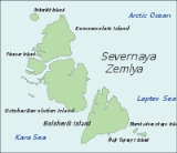
Severnaya Zemlya
Encyclopedia
Severnaya Zemlya is an archipelago
in the Russia
n high Arctic
at around 79°29.79912′N 97°19.0137′E. It is located off mainland Siberia
's Taymyr Peninsula
across the Vilkitsky Strait
. This archipelago separates two marginal seas of the Arctic Ocean, the Kara Sea
in the west and the Laptev Sea
in the east.
Severnaya Zemlya was first noted in 1913 and first charted in 1930–32, making it the last archipelago
on Earth
to be discovered. Politically, they are part of Russia
's Krasnoyarsk Krai
region, but are uninhabited by humans except for an Arctic base.
and Yakov Sannikov
in 1810 from their explorations out of Novaya Sibir.
Nested among the ice-locked waters of the Arctic Ocean, Severnaya Zemlya was not put on the map until the 1913–1915 Arctic Ocean Hydrographic Expedition of icebreaker
s Taimyr
and Vaigach
. Led by Boris Vilkitsky
, this venture accomplished its goal of exploring the uncharted areas of the Northern Sea Route
in what was seen as the culmination of an enterprise
initially conceived by emperor Peter I the Great to map the Northern Sea Route to the East.
On 22 August 1913 (3 September 1913 in the Gregorian calendar
), the expedition raised the Russian flag on what they believed to be a single island. This new land was named Emperor Nicholas II Land, (Russian: Zemliya Imperatora Nikolaya Vtorova), after Emperor Nicholas II of Russia. However, in 1926 the Presidium of the Central Executive Committee of the USSR renamed this land Severnaya Zemlya.
On 15 May 1928 the islands were overflown by Umberto Nobile
and his crew in the Airship Italia
. In the spring of 1931 the expedition of Georgy Ushakov
and Nikolay Urvantsev
(1930–1932) showed Severnaya Zemlya to be divided by four main islands, making the first detailed map of the archipelago during this expedition. The Graf Zeppelin
, during its polar flight of July 1931, determined there were at least two islands (a full month after Ushakov and Urvantsev).
The islands of Severnaya Zemlya continued to be studied by a team of geologists from NIIGA (the Scientific Research Institute of Arctic Geology) in St. Petersburg under B. Kh. Egiazarov from 1948 to 1954, who compiled a comprehensive geological map.
There has been a request at the Krasnoyarsk Territory Legislative Assembly to reinstate the former name of Severnaya Zemlya as "Emperor Nicholas II Land". This request has been rejected for the time being.
Ḍ
is the largest island of the Severnaya Zemlya group in the Russia
n Arctic
.
The area of this island has been estimated at 14170 km² (5,471.1 sq mi) making it the 56th largest island in the world. It rises to a height of 965 m (3,166 ft) on Mount Karpinsky. Half the island is covered with glacier
s reaching down into the sea. In the sections free from ice, the vegetation is desert
or tundra
. The island was first explored and named by the expedition of G.A. Ushakov and Nikolay N. Urvantsev
in 1930 – 32.
October Revolution Island houses five domed ice caps; clockwise from north, they are named: Rusanov
, Karpinsky, University, Vavilov and Albanov
. The Vavilov
Meteorological Station was operated from 1974 to 1988 on the northern part of the Vavilov Ice Cap. Other minor ice caps on the island include the Mal'yutka Glacier. The Podemnaya River and the Bolshaya River drain to the northwest between the Vavilov and Albanov
glaciers, and the Bedovaya and Obryvistaya Rivers drain to the north between Albanov and Rusanov
.
Ostrov Vysokiy is a islet located in a small bay on October Revolution Island's southwest shores.
is the southernmost and second largest island in the group, located across the Shokalsky Strait from October Revolution Island. The area of this island has been estimated at
11312 km² (4,367.6 sq mi).
Bolshevik Island is mountainous, reaching a height of 935 m (3,068 ft). and it houses an Arctic base named Prima. About 30% of the island is covered by glacier
s, while the coastal plains have a sparse vegetation of moss
and lichen
. Its northwestern shore has some fjord
s; the most important are: Fiord Tel'mana, Fiord Spartak and Fiord Partizan.
Bolshevik Island houses at least three glacier systems: Leningrad and Semenov-Tyan Shansky glaciers, as well as a smaller glacier, Kropotkin.
Ostrov Tash is a small island located on Bolshevik's southern shore. Lavrov Island is located off the NE shore and Ostrov Lishniy off its northern tip.
is the northernmost island of the Severnaya Zemlya group in the Russia
n Arctic
, and the third largest island in the group. It is the 82nd largest island on earth.
The northernmost point of the island is called the Arctic Cape
. This is the launching point for many Arctic expeditions.
The area of this island has been estimated at 9006 km² (3,477 sq mi). It rises to a height of 780 m (2,559 ft). Some 65% of island are covered with glaciers. The soil is mostly composed of loose loam
and sand
s. Komsomolets Island is home to the largest ice cap in Russia, the Academy of Sciences Ice Cap.
Komsomolets island is largely covered by the Academy of Sciences Ice Cap – an 819 m (2,687 ft) thick ice dome reaching 749 m (2,457 ft) above sea level and covers 5575 km² (2,153 sq mi) of the island.
The soil of the island is mostly composed of loose loam
and sand
s, a tundra desert scattered with mosses and lichens.
The island was first explored and named by the expedition of Georgy Ushakov
and Nikolay Urvantsev
in 1930 – 32. In keeping with their scheme of naming the islands after events and movements of the Russian Revolution
, this island was named in honour of the members of the Komsomol
, the "Communist Union of Youth".
Off the NW shores of Komsomolets Island lies a group of islets known as Ostrova Dem'yana Bednogo
.
This island houses the Pioneer Glacier.
Off Pioneer Island's southwestern end lies Krupskoy Island. This is a fairly large island, over 20 km (12.4 mi) in length and about 11 km (6.8 mi) in width. The sound that separates it from Pioneer is only 0.5 km (0.310686368324903 mi) in width.
Geological and biological data: &
This island should not be confused with Pioneer Island
in Canada (Latitude: 76° 57' 0 N, Longitude: 96° 49' 60 W). It also has nothing to do with Pioneer Island in the Tom Goes to the Mayor
comedy.
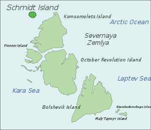 Schmidt Island
, measuring 467 km² (180 sq mi), is located at the far northwestern end of the archipelago. This island is quite detached from the whole Severnaya Zemlya group. It is also its northernmost island and is fully in the region of permanent sea ice.
This island is almost entirely covered by the Schmidt Ice Cap. Owing to its exposed position, the climate in the Schmidt Island's area is much colder than in the rest of the archipelago. The island was named after the Soviet scientist Otto Schmidt
.
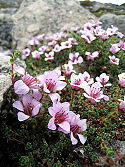 Severnaya Zemlya is a polar desert
with sparse vegetation and permafrost
at less than 50 cm. Rare vascular plants include species of Cerastium
and Saxifraga. Non-vascular plants include the moss
genera Detrichum, Dicranum
, Pogonatum, Sanionia, Bryum, Orthothecium and Tortura, as well as the lichen
genera Cetraria
, Thamnolia
, Cornicularia
, Lecidea
, Ochrolechia
and Parmelia
.
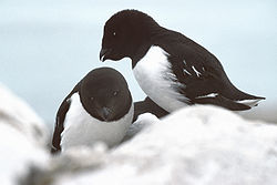 According to a survey of prior observations by De Korte, Volkov, and Gavrilo, thirty-two bird species have been observed on Severnaya Zemlya, 17 of which are known to breed on the islands. Eight species are widespread across the archipelago: five species of colonial seabirds: little auk
(Alle alle), Black-legged Kittiwake
(Rissa tridactyla), black guillemot
(Cepphus grylle), ivory gull
(Pagophila eburnea), and glaucous gull
(Larus hyperboreus); and three species of tundra bird: the snow bunting
(Plectrophenax nivalis), purple sandpiper
(Calidris maritima), and brent goose
(Branta bernicla).
The most common mammal on Severnaya Zemlya is the collared lemming
(Dicrostonyx torquatus), which is present on all of the large islands and, in some places has been recorded to reach a density of 500 per km² (1,300 per sq mi) . The Arctic fox
(Alopex lagopus) has been known to den on the islands, with several hundred observed in the 1980s. Other mammals occasionally observed include the wolf (Canis lupus), ermine
(Mustela erminea), and Arctic hare
(Lepus timidus), and reindeer
(Rangifer tarandus).
's novel, The Two Captains
as well as its stage adaptation, Nord-Ost
.
Severnaya Zemlya is annotated in the "Dorling Kindersley Reference Atlas of the World" as "Novosibiskiye Ostrova" (New Siberian Islands
). However, that is an entirely separate archipelago.
Archipelago
An archipelago , sometimes called an island group, is a chain or cluster of islands. The word archipelago is derived from the Greek ἄρχι- – arkhi- and πέλαγος – pélagos through the Italian arcipelago...
in the Russia
Russia
Russia or , officially known as both Russia and the Russian Federation , is a country in northern Eurasia. It is a federal semi-presidential republic, comprising 83 federal subjects...
n high Arctic
Arctic
The Arctic is a region located at the northern-most part of the Earth. The Arctic consists of the Arctic Ocean and parts of Canada, Russia, Greenland, the United States, Norway, Sweden, Finland, and Iceland. The Arctic region consists of a vast, ice-covered ocean, surrounded by treeless permafrost...
at around 79°29.79912′N 97°19.0137′E. It is located off mainland Siberia
Siberia
Siberia is an extensive region constituting almost all of Northern Asia. Comprising the central and eastern portion of the Russian Federation, it was part of the Soviet Union from its beginning, as its predecessor states, the Tsardom of Russia and the Russian Empire, conquered it during the 16th...
's Taymyr Peninsula
Taymyr Peninsula
The Taymyr Peninsula is a peninsula in the Far North of Russia, in the Siberian Federal District, that forms the northernmost part of mainland Eurasia and Asia...
across the Vilkitsky Strait
Vilkitsky Strait
Vilkitsky Strait is a strait between the Taimyr Peninsula and Bolshevik Island in the Severnaya Zemlya archipelago. The strait connects the Kara and Laptev Seas. The length of the Vilkitsky Strait is 104 km, the width – approx. 55 km, and the depth – between 32 and 210 m. It is...
. This archipelago separates two marginal seas of the Arctic Ocean, the Kara Sea
Kara Sea
The Kara Sea is part of the Arctic Ocean north of Siberia. It is separated from the Barents Sea to the west by the Kara Strait and Novaya Zemlya, and the Laptev Sea to the east by the Severnaya Zemlya....
in the west and the Laptev Sea
Laptev Sea
The Laptev Sea is a marginal sea of the Arctic Ocean. It is located between the northern coast of Siberia, the Taimyr Peninsula, Severnaya Zemlya and the New Siberian Islands. Its northern boundary passes from the Arctic Cape to a point with co-ordinates of 79°N and 139°E, and ends at the Anisiy...
in the east.
Severnaya Zemlya was first noted in 1913 and first charted in 1930–32, making it the last archipelago
Archipelago
An archipelago , sometimes called an island group, is a chain or cluster of islands. The word archipelago is derived from the Greek ἄρχι- – arkhi- and πέλαγος – pélagos through the Italian arcipelago...
on Earth
Earth
Earth is the third planet from the Sun, and the densest and fifth-largest of the eight planets in the Solar System. It is also the largest of the Solar System's four terrestrial planets...
to be discovered. Politically, they are part of Russia
Russia
Russia or , officially known as both Russia and the Russian Federation , is a country in northern Eurasia. It is a federal semi-presidential republic, comprising 83 federal subjects...
's Krasnoyarsk Krai
Krasnoyarsk Krai
Krasnoyarsk Krai is a federal subject of Russia . It is the second largest federal subject after the Sakha Republic, and Russia's largest krai, occupying an area of , which is 13% of the country's total territory. The administrative center of the krai is the city of Krasnoyarsk...
region, but are uninhabited by humans except for an Arctic base.
History
Although located not far off the northern coast of Russia, Severnaya Zemlya was not formally recorded until the 20th century. Earlier explorers did report a land mass in the general areas, most notably a report by Matvei GedenschtromMatvei Gedenschtrom
Matvei Matveyevich Gedenschtrom was a Russian explorer of Northern Siberia, writer, and public servant.Matvei Gedenschtrom attended University of Tartu. He did not finish his studies and left his alma mater in favor of work at Tallinn customs. Soon, however, he was arrested in connection with a...
and Yakov Sannikov
Yakov Sannikov
Yakov Sannikov was a Russian merchant and explorer of the New Siberian Islands.In 1800, Sannikov discovered and charted Stolbovoy Island, and in 1805 Faddeyevsky Island. In 1809-1810, he took part in the expedition led by Matvei Gedenschtrom. In 1810, Sannikov crossed the island of New Siberia...
in 1810 from their explorations out of Novaya Sibir.
Nested among the ice-locked waters of the Arctic Ocean, Severnaya Zemlya was not put on the map until the 1913–1915 Arctic Ocean Hydrographic Expedition of icebreaker
Icebreaker
An icebreaker is a special-purpose ship or boat designed to move and navigate through ice-covered waters. Although the term usually refers to ice-breaking ships, it may also refer to smaller vessels .For a ship to be considered an icebreaker, it requires three traits most...
s Taimyr
Icebreaker Taymyr
Icebreaker Taymyr was an icebreaking steamer of 1200 tons built for the Russian Imperial Navy at St. Petersburg in 1909. It was named after the Taymyr Peninsula....
and Vaigach
Icebreaker Vaygach
Icebreaker Vaygach was an icebreaking steamer of moderate size built for the Russian Imperial Navy at St. Petersburg in 1909. It was named after Vaygach Island in the Russian Arctic....
. Led by Boris Vilkitsky
Boris Vilkitsky
Boris Andreyevich Vilkitsky was a Russian hydrographer and surveyor. He was the son of Andrey Ippolitovich Vilkitsky....
, this venture accomplished its goal of exploring the uncharted areas of the Northern Sea Route
Northern Sea Route
The Northern Sea Route is a shipping lane officially defined by Russian legislation from the Atlantic Ocean to the Pacific Ocean specifically running along the Russian Arctic coast from Murmansk on the Barents Sea, along Siberia, to the Bering Strait and Far East. The entire route lies in Arctic...
in what was seen as the culmination of an enterprise
Great Northern Expedition
The Great Northern Expedition or Second Kamchatka expedition was one of the largest organised exploration enterprises in history, resulting in mapping of the most of the Arctic coast of Siberia and some parts of the North America coastline, greatly reducing the "white areas" on the maps...
initially conceived by emperor Peter I the Great to map the Northern Sea Route to the East.
On 22 August 1913 (3 September 1913 in the Gregorian calendar
Gregorian calendar
The Gregorian calendar, also known as the Western calendar, or Christian calendar, is the internationally accepted civil calendar. It was introduced by Pope Gregory XIII, after whom the calendar was named, by a decree signed on 24 February 1582, a papal bull known by its opening words Inter...
), the expedition raised the Russian flag on what they believed to be a single island. This new land was named Emperor Nicholas II Land, (Russian: Zemliya Imperatora Nikolaya Vtorova), after Emperor Nicholas II of Russia. However, in 1926 the Presidium of the Central Executive Committee of the USSR renamed this land Severnaya Zemlya.
On 15 May 1928 the islands were overflown by Umberto Nobile
Umberto Nobile
Umberto Nobile was an Italian aeronautical engineer and Arctic explorer. Nobile was a developer and promoter of semi-rigid airships during the Golden Age of Aviation between the two World Wars...
and his crew in the Airship Italia
Airship Italia
Airship Italia was a semi-rigid airship used by Italian engineer Umberto Nobile in his second series of flights around the North Pole.-Design and specifications:...
. In the spring of 1931 the expedition of Georgy Ushakov
Georgy Ushakov
Georgy Alexeyevich Ushakov was a Soviet explorer of the Arctic, Doctor of Geographic Sciences ....
and Nikolay Urvantsev
Nikolay Urvantsev
Nikolay Nikolayevich Urvantsev was a Soviet geologist and explorer. He was born in the town of Lukoyanov of Nizhny Novgorod Governorate, Russian Empire to the family of a merchant...
(1930–1932) showed Severnaya Zemlya to be divided by four main islands, making the first detailed map of the archipelago during this expedition. The Graf Zeppelin
LZ 127 Graf Zeppelin
LZ 127 Graf Zeppelin was a German built and operated passenger-carrying hydrogen-filled rigid airship which operated commercially from 1928 to 1937. It was named after the German pioneer of airships, Ferdinand von Zeppelin, who was a Graf or Count in the German nobility. During its operating life,...
, during its polar flight of July 1931, determined there were at least two islands (a full month after Ushakov and Urvantsev).
The islands of Severnaya Zemlya continued to be studied by a team of geologists from NIIGA (the Scientific Research Institute of Arctic Geology) in St. Petersburg under B. Kh. Egiazarov from 1948 to 1954, who compiled a comprehensive geological map.
There has been a request at the Krasnoyarsk Territory Legislative Assembly to reinstate the former name of Severnaya Zemlya as "Emperor Nicholas II Land". This request has been rejected for the time being.
Main islands
Severnaya Zemlya comprises four major islands – October Revolution, Bolshevik, Komsomolets, and Pioneer – and around 70 smaller islands, covering a total area of about 37000 km² (14,285.8 sq mi).Ḍ
October Revolution
October Revolution IslandOctober Revolution Island
October Revolution Island is the largest island of the Severnaya Zemlya group in the Russian Arctic....
is the largest island of the Severnaya Zemlya group in the Russia
Russia
Russia or , officially known as both Russia and the Russian Federation , is a country in northern Eurasia. It is a federal semi-presidential republic, comprising 83 federal subjects...
n Arctic
Arctic
The Arctic is a region located at the northern-most part of the Earth. The Arctic consists of the Arctic Ocean and parts of Canada, Russia, Greenland, the United States, Norway, Sweden, Finland, and Iceland. The Arctic region consists of a vast, ice-covered ocean, surrounded by treeless permafrost...
.
The area of this island has been estimated at 14170 km² (5,471.1 sq mi) making it the 56th largest island in the world. It rises to a height of 965 m (3,166 ft) on Mount Karpinsky. Half the island is covered with glacier
Glacier
A glacier is a large persistent body of ice that forms where the accumulation of snow exceeds its ablation over many years, often centuries. At least 0.1 km² in area and 50 m thick, but often much larger, a glacier slowly deforms and flows due to stresses induced by its weight...
s reaching down into the sea. In the sections free from ice, the vegetation is desert
Desert
A desert is a landscape or region that receives an extremely low amount of precipitation, less than enough to support growth of most plants. Most deserts have an average annual precipitation of less than...
or tundra
Tundra
In physical geography, tundra is a biome where the tree growth is hindered by low temperatures and short growing seasons. The term tundra comes through Russian тундра from the Kildin Sami word tūndâr "uplands," "treeless mountain tract." There are three types of tundra: Arctic tundra, alpine...
. The island was first explored and named by the expedition of G.A. Ushakov and Nikolay N. Urvantsev
Nikolay Urvantsev
Nikolay Nikolayevich Urvantsev was a Soviet geologist and explorer. He was born in the town of Lukoyanov of Nizhny Novgorod Governorate, Russian Empire to the family of a merchant...
in 1930 – 32.
October Revolution Island houses five domed ice caps; clockwise from north, they are named: Rusanov
Vladimir Rusanov
Vladimir Alexandrovich Rusanov was an experienced Russian geologist who specialized in the Arctic.In 1909–1911 V. A. Rusanov carried out explorations in Novaya Zemlya. He was helped by Tyko Vylka, his guide, who later became the Chairman of the Novaya Zemlya Soviet.In 1912 Rusanov had been...
, Karpinsky, University, Vavilov and Albanov
Valerian Albanov
Valerian Ivanovich Albanov was a Russian navigator, best known for being one of only two survivors of the ill-fated Brusilov expedition of 1912.-Biography:...
. The Vavilov
Sergey Ivanovich Vavilov
Sergey Ivanovich Vavilov -Biography:Vavilov founded the Soviet school of physical optics, known by his works in luminescence. In 1934 he co-discovered the Vavilov-Cherenkov effect, a discovery for which Pavel Cherenkov was awarded a Nobel Prize in Physics in 1958...
Meteorological Station was operated from 1974 to 1988 on the northern part of the Vavilov Ice Cap. Other minor ice caps on the island include the Mal'yutka Glacier. The Podemnaya River and the Bolshaya River drain to the northwest between the Vavilov and Albanov
Valerian Albanov
Valerian Ivanovich Albanov was a Russian navigator, best known for being one of only two survivors of the ill-fated Brusilov expedition of 1912.-Biography:...
glaciers, and the Bedovaya and Obryvistaya Rivers drain to the north between Albanov and Rusanov
Vladimir Rusanov
Vladimir Alexandrovich Rusanov was an experienced Russian geologist who specialized in the Arctic.In 1909–1911 V. A. Rusanov carried out explorations in Novaya Zemlya. He was helped by Tyko Vylka, his guide, who later became the Chairman of the Novaya Zemlya Soviet.In 1912 Rusanov had been...
.
Ostrov Vysokiy is a islet located in a small bay on October Revolution Island's southwest shores.
Bolshevik
Bolshevik IslandBolshevik Island
Bolshevik Island is the southernmost island of the Severnaya Zemlya group in the Russian Arctic, and the second largest island in the group...
is the southernmost and second largest island in the group, located across the Shokalsky Strait from October Revolution Island. The area of this island has been estimated at
11312 km² (4,367.6 sq mi).
Bolshevik Island is mountainous, reaching a height of 935 m (3,068 ft). and it houses an Arctic base named Prima. About 30% of the island is covered by glacier
Glacier
A glacier is a large persistent body of ice that forms where the accumulation of snow exceeds its ablation over many years, often centuries. At least 0.1 km² in area and 50 m thick, but often much larger, a glacier slowly deforms and flows due to stresses induced by its weight...
s, while the coastal plains have a sparse vegetation of moss
Moss
Mosses are small, soft plants that are typically 1–10 cm tall, though some species are much larger. They commonly grow close together in clumps or mats in damp or shady locations. They do not have flowers or seeds, and their simple leaves cover the thin wiry stems...
and lichen
Lichen
Lichens are composite organisms consisting of a symbiotic organism composed of a fungus with a photosynthetic partner , usually either a green alga or cyanobacterium...
. Its northwestern shore has some fjord
Fjord
Geologically, a fjord is a long, narrow inlet with steep sides or cliffs, created in a valley carved by glacial activity.-Formation:A fjord is formed when a glacier cuts a U-shaped valley by abrasion of the surrounding bedrock. Glacial melting is accompanied by rebound of Earth's crust as the ice...
s; the most important are: Fiord Tel'mana, Fiord Spartak and Fiord Partizan.
Bolshevik Island houses at least three glacier systems: Leningrad and Semenov-Tyan Shansky glaciers, as well as a smaller glacier, Kropotkin.
Ostrov Tash is a small island located on Bolshevik's southern shore. Lavrov Island is located off the NE shore and Ostrov Lishniy off its northern tip.
Komsomolets
Komsomolets IslandKomsomolets Island
Komsomolets Island is the northernmost island of the Severnaya Zemlya group in the Russian Arctic, and the third largest island in the group. It is the 82nd largest island on earth....
is the northernmost island of the Severnaya Zemlya group in the Russia
Russia
Russia or , officially known as both Russia and the Russian Federation , is a country in northern Eurasia. It is a federal semi-presidential republic, comprising 83 federal subjects...
n Arctic
Arctic
The Arctic is a region located at the northern-most part of the Earth. The Arctic consists of the Arctic Ocean and parts of Canada, Russia, Greenland, the United States, Norway, Sweden, Finland, and Iceland. The Arctic region consists of a vast, ice-covered ocean, surrounded by treeless permafrost...
, and the third largest island in the group. It is the 82nd largest island on earth.
The northernmost point of the island is called the Arctic Cape
Arctic Cape
The Arctic Cape is the northernmost point of the Komsomolets Island, which in turn is the northernmost island of the Russian Severnaya Zemlya archipelago in the Arctic Ocean. Its coordinates are approximately...
. This is the launching point for many Arctic expeditions.
The area of this island has been estimated at 9006 km² (3,477 sq mi). It rises to a height of 780 m (2,559 ft). Some 65% of island are covered with glaciers. The soil is mostly composed of loose loam
Loam
Loam is soil composed of sand, silt, and clay in relatively even concentration . Loam soils generally contain more nutrients and humus than sandy soils, have better infiltration and drainage than silty soils, and are easier to till than clay soils...
and sand
Sand
Sand is a naturally occurring granular material composed of finely divided rock and mineral particles.The composition of sand is highly variable, depending on the local rock sources and conditions, but the most common constituent of sand in inland continental settings and non-tropical coastal...
s. Komsomolets Island is home to the largest ice cap in Russia, the Academy of Sciences Ice Cap.
Komsomolets island is largely covered by the Academy of Sciences Ice Cap – an 819 m (2,687 ft) thick ice dome reaching 749 m (2,457 ft) above sea level and covers 5575 km² (2,153 sq mi) of the island.
The soil of the island is mostly composed of loose loam
Loam
Loam is soil composed of sand, silt, and clay in relatively even concentration . Loam soils generally contain more nutrients and humus than sandy soils, have better infiltration and drainage than silty soils, and are easier to till than clay soils...
and sand
Sand
Sand is a naturally occurring granular material composed of finely divided rock and mineral particles.The composition of sand is highly variable, depending on the local rock sources and conditions, but the most common constituent of sand in inland continental settings and non-tropical coastal...
s, a tundra desert scattered with mosses and lichens.
The island was first explored and named by the expedition of Georgy Ushakov
Georgy Ushakov
Georgy Alexeyevich Ushakov was a Soviet explorer of the Arctic, Doctor of Geographic Sciences ....
and Nikolay Urvantsev
Nikolay Urvantsev
Nikolay Nikolayevich Urvantsev was a Soviet geologist and explorer. He was born in the town of Lukoyanov of Nizhny Novgorod Governorate, Russian Empire to the family of a merchant...
in 1930 – 32. In keeping with their scheme of naming the islands after events and movements of the Russian Revolution
Russian Revolution of 1917
The Russian Revolution is the collective term for a series of revolutions in Russia in 1917, which destroyed the Tsarist autocracy and led to the creation of the Soviet Union. The Tsar was deposed and replaced by a provisional government in the first revolution of February 1917...
, this island was named in honour of the members of the Komsomol
Komsomol
The Communist Union of Youth , usually known as Komsomol , was the youth division of the Communist Party of the Soviet Union. The Komsomol in its earliest form was established in urban centers in 1918. During the early years, it was a Russian organization, known as the Russian Communist Union of...
, the "Communist Union of Youth".
Off the NW shores of Komsomolets Island lies a group of islets known as Ostrova Dem'yana Bednogo
.
Pioneer Island
Pioneer Island, Ostrov Pioner in Russian. It is the westernmost of the large islands of the Severnaya Zemlya group. Pioneer island measures 1527 km² (590 sq mi) in area.This island houses the Pioneer Glacier.
Off Pioneer Island's southwestern end lies Krupskoy Island. This is a fairly large island, over 20 km (12.4 mi) in length and about 11 km (6.8 mi) in width. The sound that separates it from Pioneer is only 0.5 km (0.310686368324903 mi) in width.
Geological and biological data: &
This island should not be confused with Pioneer Island
Pioneer Island (Nunavut)
Pioneer Island is an island of the Canadian Arctic Archipelago, in the territory of Nunavut. It lies at the northern end of Penny Strait, between Devon Island and Crescent Island ....
in Canada (Latitude: 76° 57' 0 N, Longitude: 96° 49' 60 W). It also has nothing to do with Pioneer Island in the Tom Goes to the Mayor
Tom Goes to the Mayor
Tom Goes to the Mayor is an American animated television series created by Tim Heidecker and Eric Wareheim for Cartoon Network's late night programming block, Adult Swim. It premiered on November 14, 2004 and ended on September 25, 2006, with a total of thirty episodes.-History:Tom Goes to the...
comedy.
Schmidt Island
Schmidt Island
Schmidt Island, Ostrov Shmidta in Russian, is part of the Severnaya Zemlya group in the Russian Arctic and was named after Soviet scientist and first head of the Chief Directorate of the Northern Sea Route, Otto Schmidt...
, measuring 467 km² (180 sq mi), is located at the far northwestern end of the archipelago. This island is quite detached from the whole Severnaya Zemlya group. It is also its northernmost island and is fully in the region of permanent sea ice.
This island is almost entirely covered by the Schmidt Ice Cap. Owing to its exposed position, the climate in the Schmidt Island's area is much colder than in the rest of the archipelago. The island was named after the Soviet scientist Otto Schmidt
Otto Schmidt
Otto Yulyevich Schmidt was a Soviet scientist, mathematician, astronomer, geophysicist, statesman, academician, Hero of the USSR , and member of the Communist Party.-Biography:He was born in Mogilev, Russian Empire...
.
Minor islands and island groups
- The Sedov Archipelago is located just west of October Revolution Island on the Kara Sea side. The main islands of this archipelago are Sredny (the longest island), Domashnyy, Strela, and Figurnyy. Close to the shore of October Revolution Island lies Obmannyy Island and 32 km (19.9 mi) further offshore southwards lies Dlinnyy Island. These are sometimes included as part of the Sedov Group. Golomyanniy Meteorological Station, located on the western tip of Sredniy Island at 79°33′N 90°38′E, has been taking continuous measurements since 1954. An official request has been forwarded to rename Domashnyy Island as Svyatoy Anastasii (остров Святой Анастасии), St. Anastasia Island.
- The Krasnoflotskiye Islands are located just south of October Revolution Island in the Kara Sea. They extend from north to south in an almost straight line 78°36′N 98°40′E. The main islands are Sverdlova (very close to Mys Sverdlova on the coast), Bolshoy, Sredniy and Greben far offshore. 35 km (21.7 mi) to the SW of Greben Island lie two small islets called Opasnye, which are also part of this group. There is an Arctic Station in the Krasnoflotskiye Islands (AS-042).
- Maly Taymyr Island (232 km² or 90 sq mi) is located in the Laptev Sea, off the far southeastern end of Bolshevik Island 78°07′N 107°15′E. There has been an official request to rename this island Alexei Island, after the son of Czar Nicholas II of Russia. Starokadomsky IslandStarokadomsky IslandStarokadomsky Island is an hourglass-shaped island in the Laptev Sea, Russian Arctic.It is located off the southeastern end of the Severnaya Zemlya archipelago and northeast of the Taymyr Peninsula. Maly Taymyr Island lies on its southeastern side, separated by a 6 km wide sound.The maximum...
is close by to Maly Taymyr, located off its northwestern side and separated from it by a narrow 6 km wide sound.
- Lishniy Island is 8 km (5 mi) long and 4.2 km (2.6 mi) wide. It lies in a bay off Bolshevik Island's northern end 79°11′N 103°24′E. South of it lies Yuzhnyy, a smaller island, and two islets. Lishniy off Severnaya Zemlya should not be confused with Lishniy Island south of the Firnley IslandsFirnley IslandsThe Firnley Islands, also spelt Firnleya or Firileya is a group of three small islands covered with tundra vegetation and with scattered stones on their shores. They lie in the Kara Sea, close to the bleak coast of Siberia's Taymyr Peninsula, not far east of the Nordenskjold Archipelago...
.
Climate
Severnaya Zemlya is consistently cold and dry, with a mean annual temperature of −16 °C, mean annual precipitation of about 420 mm (16.5 in), and generally overcast skies. Monthly average temperature ranges from −29 °C in February to −0.5 °C in July. The archipelago sees large temperature fluctuations during winter months, as low-pressure cyclonic activity originating in the North Atlantic make their way across the Arctic, bringing precipitation and higher temperatures. These cyclones are most common in September and October, which see 30% of annual precipitation. Snowfall in summer is common as temperatures hover around 0 °C (32 °F), although higher temperatures occur when warm air masses move north from Siberia.Flora and fauna
Polar desert
Polar deserts are areas with annual precipitation less than 250 millimeters and a mean temperature during the warmest month of less than 10°C and in the coldest month has a mean temperature of 56degress Polar deserts on Earth cover nearly 5 million square kilometers and are mostly hard bedrock or...
with sparse vegetation and permafrost
Permafrost
In geology, permafrost, cryotic soil or permafrost soil is soil at or below the freezing point of water for two or more years. Ice is not always present, as may be in the case of nonporous bedrock, but it frequently occurs and it may be in amounts exceeding the potential hydraulic saturation of...
at less than 50 cm. Rare vascular plants include species of Cerastium
Cerastium
Cerastium is a genus of annual, winter annual, or perennial plants belonging to the family Caryophyllaceae. The around 100 species are commonly called Mouse-ear chickweed; different species are found nearly worldwide but the greatest concentration is mainly from the northern temperate areas of the...
and Saxifraga. Non-vascular plants include the moss
Moss
Mosses are small, soft plants that are typically 1–10 cm tall, though some species are much larger. They commonly grow close together in clumps or mats in damp or shady locations. They do not have flowers or seeds, and their simple leaves cover the thin wiry stems...
genera Detrichum, Dicranum
Dicranum
Dicranum is a genus of mosses, also called Wind-Blown Mosses or Fork Mosses.These mosses form in densely packed clumps. Stems may fork, but do not branch. In general, upright stems will be single but packed together. These are commonly found in Jack pine or Red pine stands....
, Pogonatum, Sanionia, Bryum, Orthothecium and Tortura, as well as the lichen
Lichen
Lichens are composite organisms consisting of a symbiotic organism composed of a fungus with a photosynthetic partner , usually either a green alga or cyanobacterium...
genera Cetraria
Cetraria
Cetraria is a genus of fruticose lichens that associate with green algae as photobionts. Most species are found at high latitudes, occurring on sand or heath...
, Thamnolia
Thamnolia
Thamnolia is a genus of lichenized fungi in the family Icmadophilaceae.-Species:* Thamnolia vermicularis is a species found in may parts of the world, including high parts of Namadgi National Park in the Australian Capital Territory and Severnaya Zemlya...
, Cornicularia
Cornicularia
Cornicularia is a genus of lichenised ascomycetes in the large family Parmeliaceae. It is a monotypic genus, with only one currently accepted species: Cornicularia normoerica. This species has an erect caespitose growth form, and is sometimes referred to as the brittle lichen.-External links:* at...
, Lecidea
Lecidea
Lecidea is a lichenized genus of fungi within the Lecideaceae family. According to the Dictionary of the Fungi , the widespread genus contains an estimated 427 species....
, Ochrolechia
Ochrolechia
Ochrolechia is a genus of lichen belonging to the suborder Lecanorineae.-External links:*...
and Parmelia
Parmelia (lichen)
Parmelia is a large genus of lichenized fungus with a global distribution, extending from the Arctic to the Antarctic continent but concentrated in temperate regions. 125 species have been recorded on the Indian sub-continent...
.
Little Auk
The Little Auk, or Dovekie , is a small auk, the only member of the genus Alle. It breeds on islands in the high Arctic. There are two subspecies: A. a. alle breeds in Greenland, Iceland, Novaya Zemlya and Spitsbergen, and A. a...
(Alle alle), Black-legged Kittiwake
Black-legged Kittiwake
The Black-legged Kittiwake is a seabird species in the gull family Laridae.This species was first described by Linnaeus in his Systema naturae in 1758 as Larus tridactylus....
(Rissa tridactyla), black guillemot
Black Guillemot
The Black Guillemot or Tystie is a medium-sized alcid.Adult birds have black bodies with a white wing patch, a thin dark bill, and red legs and feet. They show white wing linings in flight. In winter, the upperparts are pale grey and the underparts are white. The wings remain black with the large...
(Cepphus grylle), ivory gull
Ivory Gull
The Ivory Gull Pagophila eburnea is a small gull, the only species in its genus. It breeds in the high arctic and has a circumpolar distribution through Greenland, northernmost North America, and Eurasia.-Taxonomy:...
(Pagophila eburnea), and glaucous gull
Glaucous Gull
The Glaucous Gull is a large gull which breeds in the Arctic regions of the northern hemisphere and the Atlantic coasts of Europe. It is migratory, wintering from in the North Atlantic and North Pacific oceans as far south as the British Isles and northernmost states of the USA, also on the Great...
(Larus hyperboreus); and three species of tundra bird: the snow bunting
Snow Bunting
The Snow Bunting , sometimes colloquially called a snowflake, is a passerine bird in the longspur family Calcariidae. It is an arctic specialist, with a circumpolar Arctic breeding range throughout the northern hemisphere...
(Plectrophenax nivalis), purple sandpiper
Purple Sandpiper
The Purple Sandpiper, Calidris, Arquatella or Erolia maritima is a small shorebird.Adults have short yellow legs and a medium thin dark bill with a yellow base. The body is dark on top with a slight purplish gloss and mainly white underneath. The breast is smeared with grey and the rump is black...
(Calidris maritima), and brent goose
Brent Goose
The Brant or Brent Goose, Branta bernicla, is a species of goose of the genus Branta. The Black Brant is an American subspecies. The specific descriptor bernicla is from the same source as "barnacle" in Barnacle Goose, which looks similar but is not a close relation.-Appearance:The Brant Goose is...
(Branta bernicla).
The most common mammal on Severnaya Zemlya is the collared lemming
Collared lemming
Dicrostonyx is a genus of rodent in the family Cricetidae. It contains the collared lemmings.It contains the following species:* Northern Collared Lemming * Ungava Collared Lemming...
(Dicrostonyx torquatus), which is present on all of the large islands and, in some places has been recorded to reach a density of 500 per km² (1,300 per sq mi) . The Arctic fox
Arctic fox
The arctic fox , also known as the white fox, polar fox or snow fox, is a small fox native to Arctic regions of the Northern Hemisphere and is common throughout the Arctic tundra biome. The Greek word alopex, means a fox and Vulpes is the Latin version...
(Alopex lagopus) has been known to den on the islands, with several hundred observed in the 1980s. Other mammals occasionally observed include the wolf (Canis lupus), ermine
Ermine
Ermine has several uses:* A common name for the stoat * The white fur and black tail end of this animal, which is historically worn by and associated with royalty and high officials...
(Mustela erminea), and Arctic hare
Arctic Hare
The arctic hare , or polar rabbit is a species of hare which is adapted largely to polar and mountainous habitats. The arctic hare survives with a thick coat of fur and usually digs holes under the ground or snow to keep warm and sleep...
(Lepus timidus), and reindeer
Reindeer
The reindeer , also known as the caribou in North America, is a deer from the Arctic and Subarctic, including both resident and migratory populations. While overall widespread and numerous, some of its subspecies are rare and one has already gone extinct.Reindeer vary considerably in color and size...
(Rangifer tarandus).
Fiction and mistakes
The discovery of Severnaya Zemlya is the subject of Veniamin KaverinVeniamin Kaverin
Veniamin Alexandrovich Kaverin was a Soviet writer associated with the early 1920s movement of the Serapion Brothers. The immunologist Lev Zilber was his older brother, and the critic Yury Tynyanov was his brother-in-law....
's novel, The Two Captains
The Two Captains
The Two Captains is a novel written by Soviet author Veniamin Kaverin between 1938 and 1944. It is Kaverin's best known work and is considered one of the most popular works of Soviet literature, winning the USSR State Prize in 1946 being reissued 42 times in 25 years...
as well as its stage adaptation, Nord-Ost
Nord-Ost
Nord-Ost is a Russian musical theatre production that was composed by Aleksei Ivaschenko and Georgii Vasilyev, based on the novel The Two Captains by Veniamin Kaverin. It is a fictional story based around the historical events surrounding the discovery of the Severnaya Zemlya archipelago in 1913...
.
Severnaya Zemlya is annotated in the "Dorling Kindersley Reference Atlas of the World" as "Novosibiskiye Ostrova" (New Siberian Islands
New Siberian Islands
The New Siberian Islands are an archipelago, located to the North of the East Siberian coast between the Laptev Sea and the East Siberian Sea north of the Sakha Republic....
). However, that is an entirely separate archipelago.
External links
- Oceandots – Severnaya Zemlya
- Arctic photos of Severnaya Zemlya by Ólafur Ingólfsson
- List of islands (Russian language)
- Geology of the Severnaya Zemlya Archipelago and the North Kara Terrane in the Russian high Arctic
- Glacial and Environmental History of Severnaya Zemlya, Siberian High Arctic, During the Last > 130,000 years
- On renaming of the islands