

Seton Portage, British Columbia
Encyclopedia
British Columbia
British Columbia is the westernmost of Canada's provinces and is known for its natural beauty, as reflected in its Latin motto, Splendor sine occasu . Its name was chosen by Queen Victoria in 1858...
, Canada
Canada
Canada is a North American country consisting of ten provinces and three territories. Located in the northern part of the continent, it extends from the Atlantic Ocean in the east to the Pacific Ocean in the west, and northward into the Arctic Ocean...
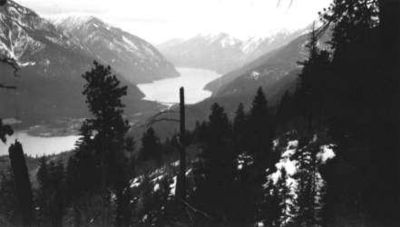
, that is about 25 km west of Lillooet
Lillooet, British Columbia
Lillooet is a community on the Fraser River in western Canada, about up the British Columbia Railway line from Vancouver. Situated at an intersection of deep gorges in the lee of the Coast Mountains, it has a dry climate- of precipitation is recorded annually at the town's weather station,...
, located between Seton Lake
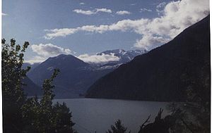
Seton Lake
Seton Lake is a freshwater fjord draining east via the Seton River into the Fraser River at the town of Lillooet, British Columbia, about 22 km long and 243 m in elevation and 26.2 square kilometres in area...
and Anderson Lake. "The Portage" was formed about 10,000 years ago when the flank of the Cayoosh Range
Cayoosh Range
The Cayoosh Range is the northernmost section of the Lillooet Ranges, which are a subrange of the Pacific Ranges of the Coast Mountains in British Columbia. The range is c...
, which is the south flank of the valley, let go and slid into the middle of what had been a single lake. The result is a location similar to Interlaken
Interlaken
Interlaken is a municipality in the Interlaken-Oberhasli administrative district in the Canton of Bern in Switzerland, a well-known tourist destination in the Bernese Oberland.-History:...
, Switzerland
Switzerland
Switzerland name of one of the Swiss cantons. ; ; ; or ), in its full name the Swiss Confederation , is a federal republic consisting of 26 cantons, with Bern as the seat of the federal authorities. The country is situated in Western Europe,Or Central Europe depending on the definition....
, with two fjord-style lakes flanking a narrow and very short strip of land between them.
There are two First Nations reserves of the Seton Lake First Nation
Seton Lake First Nation
The Seton Lake First Nation, aka the Seton Lake Indian Band, is a First Nations government located in the Central Interior-Fraser Canyon region of the Canadian province of British Columbia. It is a member of the Lillooet Tribal Council, which is the largest grouping of band governments of the...
on either end of the Portage, with the intervening area and some of the Anderson Lake shoreline taken up by a small recreational community, including a couple of orchards and small farms. There are two motels, a campground, and a pub.
Origin of the Portage
Remnants of old lake bottom survive as benchlands lining the north banks of SetonSeton Lake
Seton Lake is a freshwater fjord draining east via the Seton River into the Fraser River at the town of Lillooet, British Columbia, about 22 km long and 243 m in elevation and 26.2 square kilometres in area...
and Anderson Lakes. It may be that the glacial moraine at the foot of Seton Lake
Seton Lake
Seton Lake is a freshwater fjord draining east via the Seton River into the Fraser River at the town of Lillooet, British Columbia, about 22 km long and 243 m in elevation and 26.2 square kilometres in area...
, which had been at the foot of the Seton Glacier and, after it melted, dammed the older, larger lake in until the slide and its destructive wave (see megatsunami
Megatsunami
Megatsunami is an informal term to describe a tsunami that has initial wave heights that are much larger than normal tsunamis...
). The inundation then washed part of it away to open Seton Creek and drain the glacial melt to today's lake level, or close to it (since the lake level is 10-12 feet higher because of the power project
Bridge River Power Project
The Bridge River Power Project is a hydroelectric power development in the Canadian province of British Columbia, located in the Lillooet Country between Whistler and Lillooet...
completed in 1958).
Archaeological issues
Much of neighbouring ShalalthShalalth, British Columbia
Shalalth, pop. c. 400, is one of the main communities of the Seton Lake Band of the St'at'imc Nation and location of the two main powerhouses of the Bridge River Power Project....
is on these alluvial benches, but Seton Portage is entirely situated atop the rubble of the great slide, but covered with good soils from the inroads of vegetation over the millennia. Prior to the Fraser Canyon Gold Rush
Fraser Canyon Gold Rush
The Fraser Canyon Gold Rush, began in 1858 after gold was discovered on the Thompson River in British Columbia at its confluence with the Nicoamen River. This was a few miles upstream from the Thompson's confluence with the Fraser River at present-day Lytton...
and the Portage's role as a key component in the Douglas Road
Douglas Road
The Douglas Road, aka the Lillooet Trail, Harrison Trail or Lakes Route, was a goldrush-era transportation route from the British Columbia Coast to the Interior...
- the sheltered and fertile land of the Portage had been home to what are estimated to have been hundreds of quiggly holes (kekuli, meaning "underneath" in the Chinook Jargon
Chinook Jargon
Chinook Jargon originated as a pidgin trade language of the Pacific Northwest, and spread during the 19th century from the lower Columbia River, first to other areas in modern Oregon and Washington, then British Columbia and as far as Alaska, sometimes taking on characteristics of a creole language...
), each of which had been a house with multiple residents.
One witness to the pre-Gold Rush Portage told of coming over the mountain pass which leads into the valley from the north, and looking down on the Portage looked like "many stars in the sky". Such a description suggest a very large population, but no one knows for sure, and between smallpox and other foreign diseases, raids from neighbouring tribes in pre-Contact decades (see Nicola's War
Nicola (chief)
Nicola , also Nkwala or N'kwala, was an important First Nations political figure in the fur trade era of the British Columbia Interior as well as into the colonial period...
) and ensuing famine, the St'at'imc
St'at'imc
The St'át'imc are an Interior Salish people located in the southern Coast Mountains and Fraser Canyon region of the Interior of the Canadian province of British Columbia.St'át'imc culture displayed many features typical of Northwest Coast peoples: the...
were already reduced in population before the impacts of colonialism and industry reduced them even further.
Because of agriculture and placer activity, all signs of pre-Contact St'at'imc settlement on the Portage were obliterated. Two 1890s-vintage churches built by the Oblate Fathers, and some of the adjacent log-cabin rancherie
Rancherie
A Rancherie is a First Nations residential area of an Indian Reserve in colloquial English throughout the Canadian province of British Columbia...
s, still stand today though the one at Slosh, St. Christopher's, is in a state of decay. Heritage-preservation funding has enabled the band to restore the church at Nkait.
Population history
Population estimates of the pre-Contact populations of the Lakes Lillooet peopleSt'at'imc
The St'át'imc are an Interior Salish people located in the southern Coast Mountains and Fraser Canyon region of the Interior of the Canadian province of British Columbia.St'át'imc culture displayed many features typical of Northwest Coast peoples: the...
widely vary, with some traditions into the thousands on the Lakes alone. No one knows for sure, and the archaeological record
Archaeological record
The archaeological record is the body of physical evidence about the past. It is one of the most basic concepts in archaeology, the academic discipline concerned with documenting and interpreting the archaeological record....
here would be impossible to explore, as the land where the evidence would be has been stampeded and dug up and plowed under many times over, even on the rancherie
Rancherie
A Rancherie is a First Nations residential area of an Indian Reserve in colloquial English throughout the Canadian province of British Columbia...
s.
As concerns the Gold Rush
Fraser Canyon Gold Rush
The Fraser Canyon Gold Rush, began in 1858 after gold was discovered on the Thompson River in British Columbia at its confluence with the Nicoamen River. This was a few miles upstream from the Thompson's confluence with the Fraser River at present-day Lytton...
-era population, there is no figure for how many men were on the Portage at any one time, only an oft-repeated number of 30,000 as to the number of men that traversed the Lakes Route in the heat of the Gold Rush
Gold rush
A gold rush is a period of feverish migration of workers to an area that has had a dramatic discovery of gold. Major gold rushes took place in the 19th century in Australia, Brazil, Canada, South Africa, and the United States, while smaller gold rushes took place elsewhere.In the 19th and early...
. The beaches of the Portage were so busy with men coming and going that they were given the names Wapping
Wapping
Wapping is a place in the London Borough of Tower Hamlets which forms part of the Docklands to the east of the City of London. It is situated between the north bank of the River Thames and the ancient thoroughfare simply called The Highway...
and Flushing
Flushing
Flushing may refer to:* Flushing , the warm, red condition of human skin* Flushing , related to skirmishing* Flushing dog, a hunting dog* Flushing hydrant, a device to flush water mains...
, after the busy London Tube stations of the same names.. Within a few years that traffic had disappeared (see Douglas Road
Douglas Road
The Douglas Road, aka the Lillooet Trail, Harrison Trail or Lakes Route, was a goldrush-era transportation route from the British Columbia Coast to the Interior...
) and the non-First Nations population of the Portage from then until the arrival of the Oblates in the 1880s was few, if any at all, although travellers still occasionally used the route of which the location was intrinsically a part.
The first non-native settlers since the Gold Rush occupied lands at the Portage in the early 1900s, which provoked the Declaration of the Lillooet Tribe
Declaration of the Lillooet Tribe
The Declaration of the Lillooet Tribe is an important document in the history of relations between First Nations and the governments of the Dominion of Canada and the Province of British Columbia...
(May 10, 1911) protesting the land alienations at "the Short Portage". Further settlement came with the building of the Pacific Great Eastern Railway, which was open through the Lakes by 1914 and which required the housing and feeding of hundreds of men, and with that the beginnings of the Bridge River Power Project
Bridge River Power Project
The Bridge River Power Project is a hydroelectric power development in the Canadian province of British Columbia, located in the Lillooet Country between Whistler and Lillooet...
.
During the late 1940s and 1950s, the construction boom caused by the renewal of that project after World War II
World War II
World War II, or the Second World War , was a global conflict lasting from 1939 to 1945, involving most of the world's nations—including all of the great powers—eventually forming two opposing military alliances: the Allies and the Axis...
brought thousands of long-term temporary residents into the valley, with many of these living in temporary trailer camps and prefab houses in the Portage. Following the end of that project, the non-native population has dwindled to 400, cresting to 500 in summer with seasonal residents and visitors. Band population in total, including Shalath and the Portage together, is about 500.
History
Hudson's Bay Company
The Hudson's Bay Company , abbreviated HBC, or "The Bay" is the oldest commercial corporation in North America and one of the oldest in the world. A fur trading business for much of its existence, today Hudson's Bay Company owns and operates retail stores throughout Canada...
employees in 1828, a journey which was later followed in 1846 by Scottish
Scotland
Scotland is a country that is part of the United Kingdom. Occupying the northern third of the island of Great Britain, it shares a border with England to the south and is bounded by the North Sea to the east, the Atlantic Ocean to the north and west, and the North Channel and Irish Sea to the...
explorer Alexander Caulfield Anderson
Alexander Caulfield Anderson
Alexander Caulfield Anderson was a Hudson's Bay Company fur-trader, explorer of British Columbia and civil servant....
, who had been assigned to chart it and for whom Anderson Lake is named. Certain placenames along the route were conferred by Anderson later on, at the request of colonial Governor James Douglas
James Douglas (Governor)
Sir James Douglas KCB was a company fur-trader and a British colonial governor on Vancouver Island in northwestern North America, particularly in what is now British Columbia. Douglas worked for the North West Company, and later for the Hudson's Bay Company becoming a high-ranking company officer...
. Seton Lake
Seton Lake
Seton Lake is a freshwater fjord draining east via the Seton River into the Fraser River at the town of Lillooet, British Columbia, about 22 km long and 243 m in elevation and 26.2 square kilometres in area...
, and hence Seton Portage, was named for a friend of Anderson's who had perished in the sinking of the HMS Birkenhead
HMS Birkenhead
Two ships of the British Royal Navy have been named HMS Birkenhead, after the English town of Birkenhead.* The first Birkenhead was an iron-hulled troopship launched in 1845 and notably wrecked in 1852....
. Farther along Anderson's route to the Coast to the southwest, which later was to become the Douglas Road
Douglas Road
The Douglas Road, aka the Lillooet Trail, Harrison Trail or Lakes Route, was a goldrush-era transportation route from the British Columbia Coast to the Interior...
, there is a Mount Birkenhead, the Birkenhead River
Birkenhead River
The Birkenhead River, formerly known as the Portage River, the Pole River and the Mosquito River, is a major tributary of the Lillooet River, which via Harrison Lake and the Harrison River is one of the major tributaries of the lower Fraser River...
and Birkenhead Lake, and also the rural community of Birken and a lake of the same name. Birken Lake is the summit lake of Seton Portage's big twin, the Long Portage, aka Pemberton Pass, which separates the Birken and Seton drainages.
In 1858, gold
Gold
Gold is a chemical element with the symbol Au and an atomic number of 79. Gold is a dense, soft, shiny, malleable and ductile metal. Pure gold has a bright yellow color and luster traditionally considered attractive, which it maintains without oxidizing in air or water. Chemically, gold is a...
was discovered in British Columbia. Steamships started running on both Seton Lake
Seton Lake
Seton Lake is a freshwater fjord draining east via the Seton River into the Fraser River at the town of Lillooet, British Columbia, about 22 km long and 243 m in elevation and 26.2 square kilometres in area...
and Anderson Lake, and Seton Portage became a transportation bottleneck, as prospectors would need to portage
Portage
Portage or portaging refers to the practice of carrying watercraft or cargo over land to avoid river obstacles, or between two bodies of water. A place where this carrying occurs is also called a portage; a person doing the carrying is called a porter.The English word portage is derived from the...
for two kilometres between the lakes. In 1861, Carl Dozier constructed British Columbia's first railway
Rail transport
Rail transport is a means of conveyance of passengers and goods by way of wheeled vehicles running on rail tracks. In contrast to road transport, where vehicles merely run on a prepared surface, rail vehicles are also directionally guided by the tracks they run on...
here to transport passengers and freight
Cargo
Cargo is goods or produce transported, generally for commercial gain, by ship, aircraft, train, van or truck. In modern times, containers are used in most intermodal long-haul cargo transport.-Marine:...
across Seton Portage (then called Short Portage). Most likely the "railway" - known as Dozier's Way - was drawn by horses and mules in one direction, and run on gravity in the other - was not used much after the colonial government built the Cariboo Road
Cariboo Road
The Cariboo Road was a project initiated in 1860 by the colonial Governor of British Columbia, James Douglas...
through the Fraser River
Fraser River
The Fraser River is the longest river within British Columbia, Canada, rising at Fraser Pass near Mount Robson in the Rocky Mountains and flowing for , into the Strait of Georgia at the city of Vancouver. It is the tenth longest river in Canada...
canyon, in 1864, via Ashcroft, which bypassed Seton Portage and Lillooet
Lillooet, British Columbia
Lillooet is a community on the Fraser River in western Canada, about up the British Columbia Railway line from Vancouver. Situated at an intersection of deep gorges in the lee of the Coast Mountains, it has a dry climate- of precipitation is recorded annually at the town's weather station,...
, and was abandoned shortly thereafter (c. 1870) although its roadgrade survives today as the main local thoroughfare, Portage Road.
Following the Fraser Gold Rush
Fraser Canyon Gold Rush
The Fraser Canyon Gold Rush, began in 1858 after gold was discovered on the Thompson River in British Columbia at its confluence with the Nicoamen River. This was a few miles upstream from the Thompson's confluence with the Fraser River at present-day Lytton...
, the Seton valley lapsed into obscurity until the 1890s, when gold exploration scoured the region in the wake of the Cayoosh Gold Rush
Cayoosh Gold Rush
The Cayoosh Gold Rush was one of several in the history of the region surrounding Lillooet, British Columbia, Canada. If estimates of its yield are true, it would be one of the richest single finds in the gold mining history of that province....
of the 1880s. Alienation of native land by white settlers at the outset of the 20th century led to the Declaration of the Lillooet Tribe
Declaration of the Lillooet Tribe
The Declaration of the Lillooet Tribe is an important document in the history of relations between First Nations and the governments of the Dominion of Canada and the Province of British Columbia...
, an assertion of native ownership and sovereignty by the chiefs of the St'at'imc
St'at'imc
The St'át'imc are an Interior Salish people located in the southern Coast Mountains and Fraser Canyon region of the Interior of the Canadian province of British Columbia.St'át'imc culture displayed many features typical of Northwest Coast peoples: the...
in 1916. In 1914, the Pacific Great Eastern Railway was built through Seton Portage and its twin community Shalalth
Shalalth, British Columbia
Shalalth, pop. c. 400, is one of the main communities of the Seton Lake Band of the St'at'imc Nation and location of the two main powerhouses of the Bridge River Power Project....
, which is farther east along Seton Lake
Seton Lake
Seton Lake is a freshwater fjord draining east via the Seton River into the Fraser River at the town of Lillooet, British Columbia, about 22 km long and 243 m in elevation and 26.2 square kilometres in area...
.
Bridge River
The Bridge River is, or was, a major tributary of British Columbia's Fraser River, entering that stream about six miles upstream from the town of Lillooet.-Name:Its name in the Lillooet language is Xwisten , sometimes spelled Nxwisten or Nxo-isten)...
from the 1920s to the 1950s because of its lower elevation (255 metres) and hence warmer climate and long growing season (favorable enough for bigleaf maple
Bigleaf Maple
Acer macrophyllum is a large deciduous tree in the genus Acer.It can grow to be up to 35 m tall, but more commonly grows 15 m to 20 m tall. It is native to western North America, mostly near the Pacific coast, from southernmost Alaska to southern California...
at the northeast corner of its natural range). The locality is known for its fine fruit-growing weather - McIntosh apples grown here are considered some of the best in the world, but there is only one commercial orchard today. During the construction of the Bridge River Power Project
Bridge River Power Project
The Bridge River Power Project is a hydroelectric power development in the Canadian province of British Columbia, located in the Lillooet Country between Whistler and Lillooet...
, the population of the Portage boomed and hundreds of temporary houses and barracks were brought in to house workers and their families. It was during this period that festivities surrounding the 1958 Centennial of the Province of British Columbia
British Columbia
British Columbia is the westernmost of Canada's provinces and is known for its natural beauty, as reflected in its Latin motto, Splendor sine occasu . Its name was chosen by Queen Victoria in 1858...
saw Short Portage renamed Seton Portage. Local parlance already referred to the valley simply as "Seton", a term still in use today that collectively describes Seton Portage, Shalalth
Shalalth, British Columbia
Shalalth, pop. c. 400, is one of the main communities of the Seton Lake Band of the St'at'imc Nation and location of the two main powerhouses of the Bridge River Power Project....
and the remaining hydro company townsite at South Shalalth
Shalalth, British Columbia
Shalalth, pop. c. 400, is one of the main communities of the Seton Lake Band of the St'at'imc Nation and location of the two main powerhouses of the Bridge River Power Project....
(formerly known as Bridge River
Bridge River, British Columbia
Bridge River was used to describe three separate towns or localities in the Lillooet Country of the Interior of British Columbia connected with the river and valley of the same name.-1858-60:...
after the name of the project, not because it was on that river).
Land claims issues
St'at'imc
The St'át'imc are an Interior Salish people located in the southern Coast Mountains and Fraser Canyon region of the Interior of the Canadian province of British Columbia.St'át'imc culture displayed many features typical of Northwest Coast peoples: the...
Nation, who were demonstrating in support of the Mohawks during the Oka Crisis
Oka Crisis
The Oka Crisis was a land dispute between a group of Mohawk people and the town of Oka, Quebec, Canada which began on July 11, 1990 and lasted until September 26, 1990. At least one person died as a result...
. A day or two after a visit by then-Premier William Vander Zalm, the blockade was suppressed by the Royal Canadian Mounted Police
Royal Canadian Mounted Police
The Royal Canadian Mounted Police , literally ‘Royal Gendarmerie of Canada’; colloquially known as The Mounties, and internally as ‘The Force’) is the national police force of Canada, and one of the most recognized of its kind in the world. It is unique in the world as a national, federal,...
. The event was covered by provincial and national television news media and led to province-wide protests in support of native
Aboriginal peoples in Canada
Aboriginal peoples in Canada comprise the First Nations, Inuit and Métis. The descriptors "Indian" and "Eskimo" have fallen into disuse in Canada and are commonly considered pejorative....
land claims. Shortly afterward, the main railway bridge in Seton Portage was destroyed by an arsonist.
Access
Access to "The Portage" is via a 3500 feet (1,067 m) pass from the Bridge RiverBridge River
The Bridge River is, or was, a major tributary of British Columbia's Fraser River, entering that stream about six miles upstream from the town of Lillooet.-Name:Its name in the Lillooet language is Xwisten , sometimes spelled Nxwisten or Nxo-isten)...
known as the Mission Mountain Road, or a 25 km (15.5 mi) powerline road from D'Arcy at the farther end of Anderson Lake known as the High Line. There is no road connection along Seton Lake
Seton Lake
Seton Lake is a freshwater fjord draining east via the Seton River into the Fraser River at the town of Lillooet, British Columbia, about 22 km long and 243 m in elevation and 26.2 square kilometres in area...
, but that route is used by the British Columbia Railway, which runs a railbus
Budd Rail Diesel Car
The Budd Rail Diesel Car, RDC or Buddliner is a self-propelled diesel multiple unit railcar. In the period 1949–62, 398 RDCs were built by the Budd Company of Philadelphia, Pennsylvania, United States...
between the Seton communities and Lillooet
Lillooet, British Columbia
Lillooet is a community on the Fraser River in western Canada, about up the British Columbia Railway line from Vancouver. Situated at an intersection of deep gorges in the lee of the Coast Mountains, it has a dry climate- of precipitation is recorded annually at the town's weather station,...
, which is at the farther end of the lake.